Photos • Location
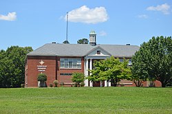
Former school

36°37′23″N 79°2′22″W / 36.62306°N 79.03944°W

Turbeville is an unincorporated community in Halifax County, Virginia, United States. It lies at an elevation of 535 feet (163 m). [1]
Municipalities and communities of
Halifax County, Virginia, United States | ||
|---|---|---|
| Towns | 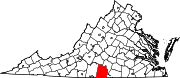 | |
| CDPs | ||
|
Unincorporated communities | ||
| Footnotes | ‡This populated place also has portions in an adjacent county or counties | |
|
| This Halifax County, Virginia state location article is a stub. You can help Wikipedia by expanding it. |
36°37′23″N 79°2′22″W / 36.62306°N 79.03944°W
Turbeville is an unincorporated community in Halifax County, Virginia, United States. It lies at an elevation of 535 feet (163 m). [1]
Municipalities and communities of
Halifax County, Virginia, United States | ||
|---|---|---|
| Towns | | |
| CDPs | ||
|
Unincorporated communities | ||
| Footnotes | ‡This populated place also has portions in an adjacent county or counties | |
|
| This Halifax County, Virginia state location article is a stub. You can help Wikipedia by expanding it. |