Photos • Location
(Redirected from
Tunka Range)
| Tunka Goltsy | |
|---|---|
| Тункинские гольцы | |
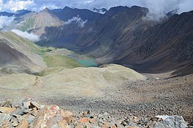
 View from Shumak Pass | |
| Highest point | |
| Peak | Strelnikov Peak |
| Elevation | 3,157 m (10,358 ft) |
| Dimensions | |
| Length | 160 km (99 mi) |
| Width | 25 km (16 mi) |
| Geography | |
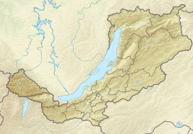
Location in
Buryatia, Russia | |
| Country | Russia |
| Federal subject | Buryatia |
| Range coordinates | 51°50′N 101°30′E / 51.833°N 101.500°E |
| Parent range |
Sayan Mountains South Siberian System |
| Geology | |
| Age of rock | Paleozoic |
| Type of rock | Crystalline schist and granite |
The Tunka Goltsy ( Russian: Тункинские гольцы) is a mountain range in Buryatia, Far Eastern Federal District, Russia. [1]
Its length is 160 km, it is the easternmost part of the Eastern Sayan.
Highest summit Strelnikov Peak (Algan Mundarga), 3157 m.
Rivers: Irkut and other tributaries of Angara River
- ^ Тункинские гольцы in the Great Soviet Encyclopedia, 1969–1978 (in Russian)
- "Tunkinskie goltsy". Archived from the original on 2007-01-01. Retrieved 2006-12-26.
(Redirected from
Tunka Range)
| Tunka Goltsy | |
|---|---|
| Тункинские гольцы | |
 View from Shumak Pass | |
| Highest point | |
| Peak | Strelnikov Peak |
| Elevation | 3,157 m (10,358 ft) |
| Dimensions | |
| Length | 160 km (99 mi) |
| Width | 25 km (16 mi) |
| Geography | |
Location in
Buryatia, Russia | |
| Country | Russia |
| Federal subject | Buryatia |
| Range coordinates | 51°50′N 101°30′E / 51.833°N 101.500°E |
| Parent range |
Sayan Mountains South Siberian System |
| Geology | |
| Age of rock | Paleozoic |
| Type of rock | Crystalline schist and granite |
The Tunka Goltsy ( Russian: Тункинские гольцы) is a mountain range in Buryatia, Far Eastern Federal District, Russia. [1]
Its length is 160 km, it is the easternmost part of the Eastern Sayan.
Highest summit Strelnikov Peak (Algan Mundarga), 3157 m.
Rivers: Irkut and other tributaries of Angara River
- ^ Тункинские гольцы in the Great Soviet Encyclopedia, 1969–1978 (in Russian)
- "Tunkinskie goltsy". Archived from the original on 2007-01-01. Retrieved 2006-12-26.
