| Tundzha, Tunca | |
|---|---|
 | |
| Location | |
| Country | Bulgaria, Turkey |
| Physical characteristics | |
| Source | |
| • location | east of Botev Peak, Stara Planina, Bulgaria |
| • coordinates | 42°43′40″N 24°58′10″E / 42.72778°N 24.96944°E |
| • elevation | 1,940 m (6,360 ft) |
| Mouth | |
• location | Maritsa at Edirne, Turkey |
• coordinates | 41°39′42″N 26°33′44″E / 41.6616°N 26.5622°E |
| Length | ca. 365 km (227 mi) (328.4 km (204.1 mi) in Bulgaria) [1] |
| Basin size | ca. 8,430 km2 (3,250 sq mi) (7,891 km2 (3,047 sq mi) in Bulgaria) [1] |
| Basin features | |
| Progression | Maritsa→ Aegean Sea |
The Tundzha ( Bulgarian: Тунджа [ˈtund͡ʒɐ], Turkish: Tunca [tund͡ʒa], Greek: Τόνζος [ˈtonzos]) is a river in Bulgaria and Turkey (known in antiquity as the Tonsus) and the most significant tributary of the Maritsa, emptying into it on Turkish territory near Edirne.
The river originates in the central parts of Stara Planina north of Kalofer, initially flowing east and then making a sharp turn to the south before Yambol, in which direction it flows until it reaches the Maritsa. The Tundzha's length is about 365 km, of which 328 km is on Bulgarian territory (including border). It has about 50 tributaries, the more important of which are Mochuritsa, Popovska, and Sinapovska.
Towns on the banks of the river include Kalofer, Yambol, and Elhovo.
Tundzha Glacier on Livingston Island in the South Shetland Islands, Antarctica is named after Tundzha River.
Pictures of Tundzha River in Yambol:
-
 Tundzha River near Kargona Quarter
 -
 The Bridge near Candy Factory
 -
 Tundzha River - between city stadium and city park


-
 The Bridge near Technical Highschool
 -
 Hotel Tundzha, Yambol
 -
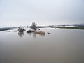 Tundzha River - flooding on Feb 18, 2010


Pictures of Tundzha River near Elhovo:
-
 Near Elhovo City Park
 -
 Near Elhovo


|
| This article related to a river in Turkey is a stub. You can help Wikipedia by expanding it. |
| Tundzha, Tunca | |
|---|---|
|
| |
| Location | |
| Country | Bulgaria, Turkey |
| Physical characteristics | |
| Source | |
| • location | east of Botev Peak, Stara Planina, Bulgaria |
| • coordinates | 42°43′40″N 24°58′10″E / 42.72778°N 24.96944°E |
| • elevation | 1,940 m (6,360 ft) |
| Mouth | |
• location | Maritsa at Edirne, Turkey |
• coordinates | 41°39′42″N 26°33′44″E / 41.6616°N 26.5622°E |
| Length | ca. 365 km (227 mi) (328.4 km (204.1 mi) in Bulgaria) [1] |
| Basin size | ca. 8,430 km2 (3,250 sq mi) (7,891 km2 (3,047 sq mi) in Bulgaria) [1] |
| Basin features | |
| Progression | Maritsa→ Aegean Sea |
The Tundzha ( Bulgarian: Тунджа [ˈtund͡ʒɐ], Turkish: Tunca [tund͡ʒa], Greek: Τόνζος [ˈtonzos]) is a river in Bulgaria and Turkey (known in antiquity as the Tonsus) and the most significant tributary of the Maritsa, emptying into it on Turkish territory near Edirne.
The river originates in the central parts of Stara Planina north of Kalofer, initially flowing east and then making a sharp turn to the south before Yambol, in which direction it flows until it reaches the Maritsa. The Tundzha's length is about 365 km, of which 328 km is on Bulgarian territory (including border). It has about 50 tributaries, the more important of which are Mochuritsa, Popovska, and Sinapovska.
Towns on the banks of the river include Kalofer, Yambol, and Elhovo.
Tundzha Glacier on Livingston Island in the South Shetland Islands, Antarctica is named after Tundzha River.
Pictures of Tundzha River in Yambol:
-
Tundzha River near Kargona Quarter
-
The Bridge near Candy Factory
-
Tundzha River - between city stadium and city park
-
The Bridge near Technical Highschool
-
Hotel Tundzha, Yambol
-
Tundzha River - flooding on Feb 18, 2010
Pictures of Tundzha River near Elhovo:
-
Near Elhovo City Park
-
Near Elhovo
|
| This article related to a river in Turkey is a stub. You can help Wikipedia by expanding it. |