| Tsugaru Fujimi Lake | |
|---|---|
| 津軽富士見湖 ( Japanese) | |
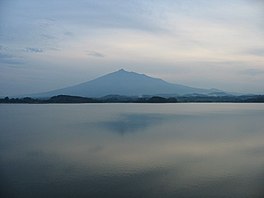
 Tsugaru Fujimi Lake with Mount Iwaki in the background | |
| Location | Aomori Prefecture, Honshū, Japan |
| Coordinates | 40°44′46″N 140°23′46″E / 40.74611°N 140.39611°E |
| Type | Reservoir |
| Primary inflows | Snowmelt |
| Primary outflows | Iwaki River |
| Basin countries | Japan |
Tsugaru Fujimi Lake (津軽富士見湖, Tsugaru Fujimi-ko) also known as Mawarizeki Ōtameike (廻堰大溜池) is a reservoir that is located almost entirely within the town of Tsuruta in Aomori Prefecture, Japan, though a portion of its southern shore lies within the city of Hirosaki. It was built in 1660 to collect snowmelt in order to irrigate the fields in the surrounding area. [1]
The reservoir's construction was ordered by Tsugaru Nobumasa, daimyō of the Hirosaki Domain in 1660 in order to collect water from snowmelt. Upon completion, its 4.2-kilometer-long (2.6 mi) retaining wall became the longest embankment dam in Japan, a record it still holds. [2] In 2010, it was selected by the Ministry of Agriculture, Forestry and Fisheries as one of the 100 best reservoirs in Japan. [3]
- ^ "廻堰大溜池" [Mawarizeki Ōtameike] (PDF) (in Japanese). Ministry of Agriculture, Forestry and Fisheries. 12 April 2019. Retrieved 14 September 2020.
- ^ "津軽富士見湖" [Tsugaru Fujimi Lake] (in Japanese). Medetai Tsuruta. 15 September 2020. Retrieved 15 September 2020.
- ^ "ため池百選" [100 Best Reservoirs] (PDF) (in Japanese). Ministry of Agriculture, Forestry and Fisheries. Retrieved 15 September 2020.
| Tsugaru Fujimi Lake | |
|---|---|
| 津軽富士見湖 ( Japanese) | |
 Tsugaru Fujimi Lake with Mount Iwaki in the background | |
| Location | Aomori Prefecture, Honshū, Japan |
| Coordinates | 40°44′46″N 140°23′46″E / 40.74611°N 140.39611°E |
| Type | Reservoir |
| Primary inflows | Snowmelt |
| Primary outflows | Iwaki River |
| Basin countries | Japan |
Tsugaru Fujimi Lake (津軽富士見湖, Tsugaru Fujimi-ko) also known as Mawarizeki Ōtameike (廻堰大溜池) is a reservoir that is located almost entirely within the town of Tsuruta in Aomori Prefecture, Japan, though a portion of its southern shore lies within the city of Hirosaki. It was built in 1660 to collect snowmelt in order to irrigate the fields in the surrounding area. [1]
The reservoir's construction was ordered by Tsugaru Nobumasa, daimyō of the Hirosaki Domain in 1660 in order to collect water from snowmelt. Upon completion, its 4.2-kilometer-long (2.6 mi) retaining wall became the longest embankment dam in Japan, a record it still holds. [2] In 2010, it was selected by the Ministry of Agriculture, Forestry and Fisheries as one of the 100 best reservoirs in Japan. [3]
- ^ "廻堰大溜池" [Mawarizeki Ōtameike] (PDF) (in Japanese). Ministry of Agriculture, Forestry and Fisheries. 12 April 2019. Retrieved 14 September 2020.
- ^ "津軽富士見湖" [Tsugaru Fujimi Lake] (in Japanese). Medetai Tsuruta. 15 September 2020. Retrieved 15 September 2020.
- ^ "ため池百選" [100 Best Reservoirs] (PDF) (in Japanese). Ministry of Agriculture, Forestry and Fisheries. Retrieved 15 September 2020.

