40°12′00″N 44°13′39″E / 40.20000°N 44.22750°E
Tsaghkalanj Ծաղկալանջ | |
|---|---|
 Tsaghkalanj Ծաղկալանջ | |
| Coordinates: 40°12′00″N 44°13′39″E / 40.20000°N 44.22750°E | |
| Country | Armenia |
| Marz (Province) | Armavir |
| Population (2008) | |
| • Total | 1,321 |
| Time zone | UTC+4 ( ) |
| • Summer ( DST) | UTC+5 ( ) |
Tsaghkalanj ( Armenian: Ծաղկալանջ, also Romanized as Tsakhkalandzh; until 1978, Agdzhakala and Aghjaghala) is a village in the Armavir Province of Armenia. The village's church, dedicated to Saint George (Surb Gevorg), dates to the 1870s. It rests on an earlier circular foundation. Nearby, is the whitewashed Amenaprkich Church of an unknown date. There is also a Neolithic- Chalcolithic tell in the village and Bronze Age burial mounds, while the ruins of Amenaprkich, a medieval settlement are nearby. [1]
Gallery
-
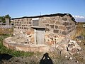 S. Gevorg chapel (1870s, restored 2003)

See also
References
- ^ Kiesling, Brady; Kojian, Raffi (2005). Rediscovering Armenia: Guide (2nd ed.). Yerevan: Matit Graphic Design Studio. p. 68. ISBN 99941-0-121-8.
- Tsaghkalanj at GEOnet Names Server
- World Gazeteer: Armenia[ dead link] – World-Gazetteer.com
- Report of the results of the 2001 Armenian Census, Statistical Committee of Armenia
- Kiesling, Brady (2005), Rediscovering Armenia: Guide, Yerevan, Armenia: Matit Graphic Design Studio
- Kiesling, Brady (June 2000). Rediscovering Armenia: An Archaeological/Touristic Gazetteer and Map Set for the Historical Monuments of Armenia (PDF). Archived (PDF) from the original on 6 November 2021.
External links

|
| This article about a location in Armavir Province, Armenia is a stub. You can help Wikipedia by expanding it. |
40°12′00″N 44°13′39″E / 40.20000°N 44.22750°E
Tsaghkalanj Ծաղկալանջ | |
|---|---|
Tsaghkalanj Ծաղկալանջ | |
| Coordinates: 40°12′00″N 44°13′39″E / 40.20000°N 44.22750°E | |
| Country | Armenia |
| Marz (Province) | Armavir |
| Population (2008) | |
| • Total | 1,321 |
| Time zone | UTC+4 ( ) |
| • Summer ( DST) | UTC+5 ( ) |
Tsaghkalanj ( Armenian: Ծաղկալանջ, also Romanized as Tsakhkalandzh; until 1978, Agdzhakala and Aghjaghala) is a village in the Armavir Province of Armenia. The village's church, dedicated to Saint George (Surb Gevorg), dates to the 1870s. It rests on an earlier circular foundation. Nearby, is the whitewashed Amenaprkich Church of an unknown date. There is also a Neolithic- Chalcolithic tell in the village and Bronze Age burial mounds, while the ruins of Amenaprkich, a medieval settlement are nearby. [1]
Gallery
-
S. Gevorg chapel (1870s, restored 2003)
See also
References
- ^ Kiesling, Brady; Kojian, Raffi (2005). Rediscovering Armenia: Guide (2nd ed.). Yerevan: Matit Graphic Design Studio. p. 68. ISBN 99941-0-121-8.
- Tsaghkalanj at GEOnet Names Server
- World Gazeteer: Armenia[ dead link] – World-Gazetteer.com
- Report of the results of the 2001 Armenian Census, Statistical Committee of Armenia
- Kiesling, Brady (2005), Rediscovering Armenia: Guide, Yerevan, Armenia: Matit Graphic Design Studio
- Kiesling, Brady (June 2000). Rediscovering Armenia: An Archaeological/Touristic Gazetteer and Map Set for the Historical Monuments of Armenia (PDF). Archived (PDF) from the original on 6 November 2021.
External links
|
| This article about a location in Armavir Province, Armenia is a stub. You can help Wikipedia by expanding it. |