Tresnuraghes | |
|---|---|
| Comune di Tresnuraghes | |
.jpg) San Giorgio | |
 Coat of arms | |
 Tresnuraghes Location of Tresnuraghes in Sardinia  Tresnuraghes Tresnuraghes (Sardinia) | |
| Coordinates: 40°15′N 8°31′E / 40.250°N 8.517°E | |
| Country | Italy |
| Region | Sardinia |
| Province | Oristano (OR) |
| Frazioni | Porto Alabe |
| Area | |
| • Total | 31.55 km2 (12.18 sq mi) |
| Elevation | 257 m (843 ft) |
| Population (Dec. 2004)
[2] | |
| • Total | 1,261 |
| • Density | 40/km2 (100/sq mi) |
| Demonym | Tresnuraghesi |
| Time zone | UTC+1 ( CET) |
| • Summer ( DST) | UTC+2 ( CEST) |
| Postal code | 09079 |
| Dialing code | 0785 |
| Patron saint | St. George |
| Saint day | April 23 |
| Website | Official website |
Tresnuraghes is a comune (municipality) in the Province of Oristano in the Italian region Sardinia, located about 130 kilometres (81 mi) northwest of Cagliari and about 40 kilometres (25 mi) north of Oristano. The name means three nuraghes in Sardinian.
Geography
Tresnuraghes borders the following municipalities: Cuglieri, Flussio, Magomadas, Sennariolo.
Festivals
The Feast of Saint Mark is a traditional Sardinian feste, the most important one, which is a time of excess consumption that helps solidify the social community. Local shepherd families in this predominantly pastoral community offer sheep and oversee cooking them in a gesture of thanks to Providence. Other families offer bread as thanksgiving or for favors desired. Hundreds of people, mostly from Tresnuraghes, but a large number of outsiders as well, eat and drink to satiation together. [3]
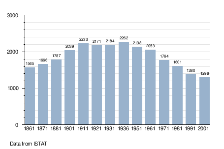
Demographic evolution
See table below.

References
- ^ "Superficie di Comuni Province e Regioni italiane al 9 ottobre 2011". Italian National Institute of Statistics. Retrieved 16 March 2019.
- ^ All demographics and other statistics: Italian statistical institute Istat.
- ^ Counihan, Carole, The Anthropology of Food and Body, p. 39
External links

| International | |
|---|---|
| National | |
|
| This Sardinia location article is a stub. You can help Wikipedia by expanding it. |
Tresnuraghes | |
|---|---|
| Comune di Tresnuraghes | |
|
San Giorgio | |
|
Coat of arms | |
Tresnuraghes Location of Tresnuraghes in Sardinia Tresnuraghes Tresnuraghes (Sardinia) | |
| Coordinates: 40°15′N 8°31′E / 40.250°N 8.517°E | |
| Country | Italy |
| Region | Sardinia |
| Province | Oristano (OR) |
| Frazioni | Porto Alabe |
| Area | |
| • Total | 31.55 km2 (12.18 sq mi) |
| Elevation | 257 m (843 ft) |
| Population (Dec. 2004)
[2] | |
| • Total | 1,261 |
| • Density | 40/km2 (100/sq mi) |
| Demonym | Tresnuraghesi |
| Time zone | UTC+1 ( CET) |
| • Summer ( DST) | UTC+2 ( CEST) |
| Postal code | 09079 |
| Dialing code | 0785 |
| Patron saint | St. George |
| Saint day | April 23 |
| Website | Official website |
Tresnuraghes is a comune (municipality) in the Province of Oristano in the Italian region Sardinia, located about 130 kilometres (81 mi) northwest of Cagliari and about 40 kilometres (25 mi) north of Oristano. The name means three nuraghes in Sardinian.
Geography
Tresnuraghes borders the following municipalities: Cuglieri, Flussio, Magomadas, Sennariolo.
Festivals
The Feast of Saint Mark is a traditional Sardinian feste, the most important one, which is a time of excess consumption that helps solidify the social community. Local shepherd families in this predominantly pastoral community offer sheep and oversee cooking them in a gesture of thanks to Providence. Other families offer bread as thanksgiving or for favors desired. Hundreds of people, mostly from Tresnuraghes, but a large number of outsiders as well, eat and drink to satiation together. [3]
Demographic evolution
See table below.
References
- ^ "Superficie di Comuni Province e Regioni italiane al 9 ottobre 2011". Italian National Institute of Statistics. Retrieved 16 March 2019.
- ^ All demographics and other statistics: Italian statistical institute Istat.
- ^ Counihan, Carole, The Anthropology of Food and Body, p. 39
External links
| International | |
|---|---|
| National | |
|
| This Sardinia location article is a stub. You can help Wikipedia by expanding it. |