Toyama
戸山 | |
|---|---|
District | |
 | |
| Coordinates: 35°42′13.298″N 139°42′51.224″E / 35.70369389°N 139.71422889°E | |
| Country | Japan |
| City | Tokyo |
| Ward | Shinjuku |
| Population (December 1, 2017)
[1] | |
| • Total | 9,203 |
| Time zone | UTC+9 ( JST) |
| Postal code | |
| Area code | 03 |
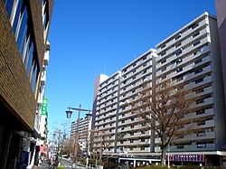
Toyama (戸山) is a district of Shinjuku, Tokyo, Japan. It is known for Toyama Heights, one of the first and largest danchi (public housing) complexes in Tokyo for low-income households. [4]
Education
The Shinjuku City Board of Education operates public elementary and junior high schools.
Toyama 2- chome and portions of 1-chome (20-21 ban) and most of 3-chome are zoned to Higashitoyama Elementary School (東戸山小学校). The rest of 1-chome is zoned to Waseda Elementary School ( 早稲田小学校). 3-chome 18-ban is zoned to Toyama Elementary School (戸山小学校). 3-chome 21-ban is zoned to Totsuka No. 2 Elementary School ( 戸塚第二小学校). Almost all of Toyama is zoned to Shinjuku Junior High School ( 新宿中学校). However 3-chome 18-ban and 21-ban are zoned instead to Nishiwaseda Junior High School ( 新宿区立西早稲田中学校). [5]
References
- ^ "住民基本台帳人口 町丁別世帯数及び男女別人口". 新宿区. 2017-12-01. Retrieved 2017-12-22.
- ^ "郵便番号". 日本郵便. Retrieved 2017-12-22.
- ^ "郵便番号". 日本郵便. Retrieved 2017-12-22.
- ^ "戸山ハイツ(都営住宅建替え)|プロジェクト紹介". 市浦ハウジング&プランニング. Archived from the original on 2021-05-15. Retrieved 2020-05-06.
- ^ "町名別学区域一覧表". Shinjuku City. Retrieved 2022-10-11.
Toyama
戸山 | |
|---|---|
District | |
 | |
| Coordinates: 35°42′13.298″N 139°42′51.224″E / 35.70369389°N 139.71422889°E | |
| Country | Japan |
| City | Tokyo |
| Ward | Shinjuku |
| Population (December 1, 2017)
[1] | |
| • Total | 9,203 |
| Time zone | UTC+9 ( JST) |
| Postal code | |
| Area code | 03 |
Toyama (戸山) is a district of Shinjuku, Tokyo, Japan. It is known for Toyama Heights, one of the first and largest danchi (public housing) complexes in Tokyo for low-income households. [4]
Education
The Shinjuku City Board of Education operates public elementary and junior high schools.
Toyama 2- chome and portions of 1-chome (20-21 ban) and most of 3-chome are zoned to Higashitoyama Elementary School (東戸山小学校). The rest of 1-chome is zoned to Waseda Elementary School ( 早稲田小学校). 3-chome 18-ban is zoned to Toyama Elementary School (戸山小学校). 3-chome 21-ban is zoned to Totsuka No. 2 Elementary School ( 戸塚第二小学校). Almost all of Toyama is zoned to Shinjuku Junior High School ( 新宿中学校). However 3-chome 18-ban and 21-ban are zoned instead to Nishiwaseda Junior High School ( 新宿区立西早稲田中学校). [5]
References
- ^ "住民基本台帳人口 町丁別世帯数及び男女別人口". 新宿区. 2017-12-01. Retrieved 2017-12-22.
- ^ "郵便番号". 日本郵便. Retrieved 2017-12-22.
- ^ "郵便番号". 日本郵便. Retrieved 2017-12-22.
- ^ "戸山ハイツ(都営住宅建替え)|プロジェクト紹介". 市浦ハウジング&プランニング. Archived from the original on 2021-05-15. Retrieved 2020-05-06.
- ^ "町名別学区域一覧表". Shinjuku City. Retrieved 2022-10-11.

