Tjøtta Municipality
Tjøtta herred | |
|---|---|
 Nordland within Norway | |
 Tjøtta within Nordland | |
| Coordinates: 65°50′19″N 12°27′15″E / 65.8386°N 12.4542°E | |
| Country | Norway |
| County | Nordland |
| District | Helgeland |
| Established | 1862 |
| • Preceded by | Alstahaug |
| Disestablished | 1 Jan 1965 |
| • Succeeded by | Alstahaug and Vega |
| Administrative centre | Tjøtta |
| Area (upon dissolution) | |
| • Total | 326 km2 (126 sq mi) |
| Population (1965) | |
| • Total | 1,673 |
| • Density | 5.1/km2 (13/sq mi) |
| Demonym | Tjøttværing [1] |
| Time zone | UTC+01:00 ( CET) |
| • Summer ( DST) | UTC+02:00 ( CEST) |
| ISO 3166 code | NO-1817 [2] |
Tjøtta is a former municipality in Nordland county, Norway. The 326-square-kilometre (126 sq mi) municipality existed from 1862 until its dissolution in 1965. The municipality was centered around the island of Tjøtta plus the mainland to the east and south as well as over 3000 islands, islets, and skerries to the west. The administrative centre of Tjøtta was the village of Tjøtta, located on the island of Tjøtta, where the Tjøtta Church is located. [3] [4]
History
The municipality of Tjøtta was established in 1862 when it was separated from Alstahaug Municipality. Initially, Tjøtta had a population of 2,781. On 1 July 1917, the southeastern district of Tjøtta (population: 1,097) was separated to become the new Vevelstad Municipality, leaving Tjøtta with 2,287 inhabitants. On 1 July 1920 the Giskåen farm with 10 inhabitants was transferred to Vevelstad. [5]
During the 1960s, there were many municipal mergers across Norway due to the work of the Schei Committee. On 1 January 1964, the part of Tjøtta located on the eastern part of the island of Alsten (population: 180) was incorporated into Leirfjord Municipality. On 1 January 1965, the Skogsholmen island area in western Tjøtta (population: 196) was incorporated into Vega Municipality. The rest of Tjøtta Municipality (population: 1,477) was merged with most of Alstahaug Municipality (population: 920) and the town of Sandnessjøen (population: 3,856). [5]
Name
The municipality (originally the parish) is named after the old Tjøtta farm ( Old Norse: Þjótta) since the first Tjøtta Church was built there. The name of the farm (and the island on which it is located) comes from the word þjó which is a noun describing the "upper part of a thigh". The name was likely used to refer to the shape of the island. [6] [7]
Government
While it existed, this municipality was responsible for primary education (through 10th grade), outpatient health services, senior citizen services, unemployment, social services, zoning, economic development, and municipal roads. During its existence, this municipality was governed by a municipal council of elected representatives, which in turn elected a mayor. [8]
Municipal council
The municipal council (Herredsstyre) of Tjøtta was made up of 17 representatives that were elected to four year terms. The party breakdown of the final municipal council was as follows:
| Party name (in Norwegian) | Number of representatives | |
|---|---|---|
| Labour Party (Arbeiderpartiet) | 8 | |
| Liberal Party (Venstre) | 3 | |
| List of workers, fishermen, and small farmholders (Arbeidere, fiskere, småbrukere liste) | 2 | |
| Joint List(s) of Non-Socialist Parties (Borgerlige Felleslister) | 4 | |
| Total number of members: | 17 | |
| Party name (in Norwegian) | Number of representatives | |
|---|---|---|
| Labour Party (Arbeiderpartiet) | 6 | |
| Conservative Party (Høyre) | 1 | |
| Liberal Party (Venstre) | 2 | |
| Local List(s) (Lokale lister) | 8 | |
| Total number of members: | 17 | |
| Party name (in Norwegian) | Number of representatives | |
|---|---|---|
| Labour Party (Arbeiderpartiet) | 5 | |
| Liberal Party (Venstre) | 1 | |
| Joint List(s) of Non-Socialist Parties (Borgerlige Felleslister) | 8 | |
| Local List(s) (Lokale lister) | 3 | |
| Total number of members: | 17 | |
| Party name (in Norwegian) | Number of representatives | |
|---|---|---|
| Labour Party (Arbeiderpartiet) | 5 | |
| Conservative Party (Høyre) | 1 | |
| Liberal Party (Venstre) | 3 | |
| Local List(s) (Lokale lister) | 7 | |
| Total number of members: | 16 | |
| Party name (in Norwegian) | Number of representatives | |
|---|---|---|
| Labour Party (Arbeiderpartiet) | 3 | |
| Liberal Party (Venstre) | 3 | |
| List of workers, fishermen, and small farmholders (Arbeidere, fiskere, småbrukere liste) | 3 | |
| Joint List(s) of Non-Socialist Parties (Borgerlige Felleslister) | 3 | |
| Local List(s) (Lokale lister) | 4 | |
| Total number of members: | 16 | |
| Party name (in Norwegian) | Number of representatives | |
|---|---|---|
| Labour Party (Arbeiderpartiet) | 4 | |
| List of workers, fishermen, and small farmholders (Arbeidere, fiskere, småbrukere liste) | 4 | |
| Local List(s) (Lokale lister) | 8 | |
| Total number of members: | 16 | |
| Party name (in Norwegian) | Number of representatives | |
|---|---|---|
| Labour Party (Arbeiderpartiet) | 5 | |
| Local List(s) (Lokale lister) | 11 | |
| Total number of members: | 16 | |
| Note: Due to the German occupation of Norway during World War II, no elections were held for new municipal councils until after the war ended in 1945. | ||
Media gallery
-
 Tjøtta is located on Strandflaten lowland near the sea
 -
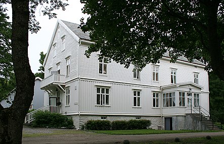 Tjøtta gard, the old Tjøtta farm now the site of a guesthouse
 -
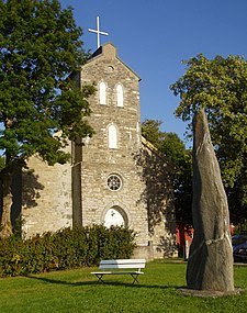 Tjøtta kyrkje, Tjøtta Church


See also
References
- ^ "Navn på steder og personer: Innbyggjarnamn" (in Norwegian). Språkrådet.
- ^ Bolstad, Erik; Thorsnæs, Geir, eds. (26 January 2023). "Kommunenummer". Store norske leksikon (in Norwegian). Kunnskapsforlaget.
- ^ Thorsnæs, Geir, ed. (16 May 2016). "Tjøtta – tidligere kommune". Store norske leksikon (in Norwegian). Kunnskapsforlaget. Retrieved 20 September 2018.
- ^ Helland, Amund (1908). "Tjøtta herred". Norges land og folk: Nordlands amt (in Norwegian). Vol. XVIII. Kristiania, Norway: H. Aschehoug & Company. p. 172. Retrieved 20 September 2018.
- ^ a b Jukvam, Dag (1999). "Historisk oversikt over endringer i kommune- og fylkesinndelingen" (PDF) (in Norwegian). Statistisk sentralbyrå. ISBN 9788253746845.
- ^ Rygh, Oluf (1905). Norske gaardnavne: Nordlands amt (in Norwegian) (16 ed.). Kristiania, Norge: W. C. Fabritius & sønners bogtrikkeri.
- ^ Thorsnæs, Geir, ed. (24 March 2020). "Tjøtta – øy". Store norske leksikon (in Norwegian). Kunnskapsforlaget. Retrieved 11 March 2023.
- ^ Hansen, Tore; Vabo, Signy Irene, eds. (20 September 2022). "kommunestyre". Store norske leksikon (in Norwegian). Kunnskapsforlaget. Retrieved 1 January 2023.
- ^ "Kommunevalgene 1963" (PDF) (in Norwegian). Oslo: Statistisk sentralbyrå. 1964. Retrieved 18 March 2020.
- ^ "Kommunevalgene og Ordførervalgene 1959" (PDF) (in Norwegian). Oslo: Statistisk sentralbyrå. 1960. Retrieved 18 March 2020.
- ^ "Kommunevalgene og Ordførervalgene 1955" (PDF) (in Norwegian). Oslo: Statistisk sentralbyrå. 1957. Retrieved 18 March 2020.
- ^ "Kommunevalgene og Ordførervalgene 1951" (PDF) (in Norwegian). Oslo: Statistisk sentralbyrå. 1952. Retrieved 18 March 2020.
- ^ "Kommunevalgene og Ordførervalgene 1947" (PDF) (in Norwegian). Oslo: Statistisk sentralbyrå. 1948. Retrieved 18 March 2020.
- ^ "Kommunevalgene og Ordførervalgene 1945" (PDF) (in Norwegian). Oslo: Statistisk sentralbyrå. 1947. Retrieved 18 March 2020.
- ^ "Kommunevalgene og Ordførervalgene 1937" (PDF) (in Norwegian). Oslo: Statistisk sentralbyrå. 1938. Retrieved 18 March 2020.
| |||||||||||
 | Towns and cities |
| |||||||||
| Municipalities |
| ||||||||||
| |||||||||||
Tjøtta Municipality
Tjøtta herred | |
|---|---|
|
Nordland within Norway | |
|
Tjøtta within Nordland | |
| Coordinates: 65°50′19″N 12°27′15″E / 65.8386°N 12.4542°E | |
| Country | Norway |
| County | Nordland |
| District | Helgeland |
| Established | 1862 |
| • Preceded by | Alstahaug |
| Disestablished | 1 Jan 1965 |
| • Succeeded by | Alstahaug and Vega |
| Administrative centre | Tjøtta |
| Area (upon dissolution) | |
| • Total | 326 km2 (126 sq mi) |
| Population (1965) | |
| • Total | 1,673 |
| • Density | 5.1/km2 (13/sq mi) |
| Demonym | Tjøttværing [1] |
| Time zone | UTC+01:00 ( CET) |
| • Summer ( DST) | UTC+02:00 ( CEST) |
| ISO 3166 code | NO-1817 [2] |
Tjøtta is a former municipality in Nordland county, Norway. The 326-square-kilometre (126 sq mi) municipality existed from 1862 until its dissolution in 1965. The municipality was centered around the island of Tjøtta plus the mainland to the east and south as well as over 3000 islands, islets, and skerries to the west. The administrative centre of Tjøtta was the village of Tjøtta, located on the island of Tjøtta, where the Tjøtta Church is located. [3] [4]
History
The municipality of Tjøtta was established in 1862 when it was separated from Alstahaug Municipality. Initially, Tjøtta had a population of 2,781. On 1 July 1917, the southeastern district of Tjøtta (population: 1,097) was separated to become the new Vevelstad Municipality, leaving Tjøtta with 2,287 inhabitants. On 1 July 1920 the Giskåen farm with 10 inhabitants was transferred to Vevelstad. [5]
During the 1960s, there were many municipal mergers across Norway due to the work of the Schei Committee. On 1 January 1964, the part of Tjøtta located on the eastern part of the island of Alsten (population: 180) was incorporated into Leirfjord Municipality. On 1 January 1965, the Skogsholmen island area in western Tjøtta (population: 196) was incorporated into Vega Municipality. The rest of Tjøtta Municipality (population: 1,477) was merged with most of Alstahaug Municipality (population: 920) and the town of Sandnessjøen (population: 3,856). [5]
Name
The municipality (originally the parish) is named after the old Tjøtta farm ( Old Norse: Þjótta) since the first Tjøtta Church was built there. The name of the farm (and the island on which it is located) comes from the word þjó which is a noun describing the "upper part of a thigh". The name was likely used to refer to the shape of the island. [6] [7]
Government
While it existed, this municipality was responsible for primary education (through 10th grade), outpatient health services, senior citizen services, unemployment, social services, zoning, economic development, and municipal roads. During its existence, this municipality was governed by a municipal council of elected representatives, which in turn elected a mayor. [8]
Municipal council
The municipal council (Herredsstyre) of Tjøtta was made up of 17 representatives that were elected to four year terms. The party breakdown of the final municipal council was as follows:
| Party name (in Norwegian) | Number of representatives | |
|---|---|---|
| Labour Party (Arbeiderpartiet) | 8 | |
| Liberal Party (Venstre) | 3 | |
| List of workers, fishermen, and small farmholders (Arbeidere, fiskere, småbrukere liste) | 2 | |
| Joint List(s) of Non-Socialist Parties (Borgerlige Felleslister) | 4 | |
| Total number of members: | 17 | |
| Party name (in Norwegian) | Number of representatives | |
|---|---|---|
| Labour Party (Arbeiderpartiet) | 6 | |
| Conservative Party (Høyre) | 1 | |
| Liberal Party (Venstre) | 2 | |
| Local List(s) (Lokale lister) | 8 | |
| Total number of members: | 17 | |
| Party name (in Norwegian) | Number of representatives | |
|---|---|---|
| Labour Party (Arbeiderpartiet) | 5 | |
| Liberal Party (Venstre) | 1 | |
| Joint List(s) of Non-Socialist Parties (Borgerlige Felleslister) | 8 | |
| Local List(s) (Lokale lister) | 3 | |
| Total number of members: | 17 | |
| Party name (in Norwegian) | Number of representatives | |
|---|---|---|
| Labour Party (Arbeiderpartiet) | 5 | |
| Conservative Party (Høyre) | 1 | |
| Liberal Party (Venstre) | 3 | |
| Local List(s) (Lokale lister) | 7 | |
| Total number of members: | 16 | |
| Party name (in Norwegian) | Number of representatives | |
|---|---|---|
| Labour Party (Arbeiderpartiet) | 3 | |
| Liberal Party (Venstre) | 3 | |
| List of workers, fishermen, and small farmholders (Arbeidere, fiskere, småbrukere liste) | 3 | |
| Joint List(s) of Non-Socialist Parties (Borgerlige Felleslister) | 3 | |
| Local List(s) (Lokale lister) | 4 | |
| Total number of members: | 16 | |
| Party name (in Norwegian) | Number of representatives | |
|---|---|---|
| Labour Party (Arbeiderpartiet) | 4 | |
| List of workers, fishermen, and small farmholders (Arbeidere, fiskere, småbrukere liste) | 4 | |
| Local List(s) (Lokale lister) | 8 | |
| Total number of members: | 16 | |
| Party name (in Norwegian) | Number of representatives | |
|---|---|---|
| Labour Party (Arbeiderpartiet) | 5 | |
| Local List(s) (Lokale lister) | 11 | |
| Total number of members: | 16 | |
| Note: Due to the German occupation of Norway during World War II, no elections were held for new municipal councils until after the war ended in 1945. | ||
Media gallery
-
Tjøtta is located on Strandflaten lowland near the sea
-
Tjøtta gard, the old Tjøtta farm now the site of a guesthouse
-
Tjøtta kyrkje, Tjøtta Church
See also
References
- ^ "Navn på steder og personer: Innbyggjarnamn" (in Norwegian). Språkrådet.
- ^ Bolstad, Erik; Thorsnæs, Geir, eds. (26 January 2023). "Kommunenummer". Store norske leksikon (in Norwegian). Kunnskapsforlaget.
- ^ Thorsnæs, Geir, ed. (16 May 2016). "Tjøtta – tidligere kommune". Store norske leksikon (in Norwegian). Kunnskapsforlaget. Retrieved 20 September 2018.
- ^ Helland, Amund (1908). "Tjøtta herred". Norges land og folk: Nordlands amt (in Norwegian). Vol. XVIII. Kristiania, Norway: H. Aschehoug & Company. p. 172. Retrieved 20 September 2018.
- ^ a b Jukvam, Dag (1999). "Historisk oversikt over endringer i kommune- og fylkesinndelingen" (PDF) (in Norwegian). Statistisk sentralbyrå. ISBN 9788253746845.
- ^ Rygh, Oluf (1905). Norske gaardnavne: Nordlands amt (in Norwegian) (16 ed.). Kristiania, Norge: W. C. Fabritius & sønners bogtrikkeri.
- ^ Thorsnæs, Geir, ed. (24 March 2020). "Tjøtta – øy". Store norske leksikon (in Norwegian). Kunnskapsforlaget. Retrieved 11 March 2023.
- ^ Hansen, Tore; Vabo, Signy Irene, eds. (20 September 2022). "kommunestyre". Store norske leksikon (in Norwegian). Kunnskapsforlaget. Retrieved 1 January 2023.
- ^ "Kommunevalgene 1963" (PDF) (in Norwegian). Oslo: Statistisk sentralbyrå. 1964. Retrieved 18 March 2020.
- ^ "Kommunevalgene og Ordførervalgene 1959" (PDF) (in Norwegian). Oslo: Statistisk sentralbyrå. 1960. Retrieved 18 March 2020.
- ^ "Kommunevalgene og Ordførervalgene 1955" (PDF) (in Norwegian). Oslo: Statistisk sentralbyrå. 1957. Retrieved 18 March 2020.
- ^ "Kommunevalgene og Ordførervalgene 1951" (PDF) (in Norwegian). Oslo: Statistisk sentralbyrå. 1952. Retrieved 18 March 2020.
- ^ "Kommunevalgene og Ordførervalgene 1947" (PDF) (in Norwegian). Oslo: Statistisk sentralbyrå. 1948. Retrieved 18 March 2020.
- ^ "Kommunevalgene og Ordførervalgene 1945" (PDF) (in Norwegian). Oslo: Statistisk sentralbyrå. 1947. Retrieved 18 March 2020.
- ^ "Kommunevalgene og Ordførervalgene 1937" (PDF) (in Norwegian). Oslo: Statistisk sentralbyrå. 1938. Retrieved 18 March 2020.
| |||||||||||
| Towns and cities |
| |||||||||
| Municipalities |
| ||||||||||
| |||||||||||