| Tioga Peak | |
|---|---|
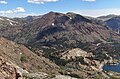
 South aspect, with Tioga Lake | |
| Highest point | |
| Elevation | 11,526 ft (3,513 m) NAVD 88 [1] |
| Prominence | 1,006 ft (307 m) [1] |
| Isolation | 2.71 mi (4.36 km) [2] |
| Coordinates | 37°56′58″N 119°14′47″W / 37.94944°N 119.24639°W [1] |
| Geography | |
 Tioga Peak Location in California  Tioga Peak Tioga Peak (the United States) | |
| Location | Mono County, California, U.S. |
| Parent range | Sierra Nevada |
| Topo map | USGS Mount Dana |
| Climbing | |
| Easiest route | class 2 scrambling [2] |
Tioga Peak is located in Mono County, California, approximately two miles outside of Yosemite National Park. It is situated in the Hoover Wilderness on land managed by Inyo National Forest. [3]
The location of Tioga Peak
Tioga Peak is three miles north-northeast of Tioga Pass, at the head of Lee Vining Canyon. Highway 120 traverses its south and east slopes. It is easily accessible, a class 1 to class 2 scramble, from Gardisky Lake. The summit is like a rolling dome. It has some of the best views of the Tioga Pass region. [3]
Both Mount Dana and Tioga Pass are visible from the summit. [3]
Tioga Peak is a rounded peak, made of metamorphic rock. [3]
Climate
Tioga Peak is located in an alpine climate zone. [4] Most weather fronts originate in the Pacific Ocean, and travel east toward the Sierra Nevada mountains. As fronts approach, they are forced upward by the peaks ( orographic lift), causing moisture in the form of rain or snowfall to drop onto the range. Precipitation runoff from this mountain drains to Lee Vining Creek and ultimately Mono Lake.
Gallery
-
 East aspect of Tioga Peak from Lee Vining Canyon
 -
 South aspect, from Gaylor Peak
 -
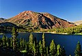 Tioga Peak from Tioga Lake
 -
 Tioga Peak (right) from Tioga Lake
 -
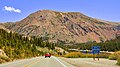 Tioga Peak from Highway 120


.jpg)
See also
References
- ^ a b c "Tioga Peak, California". Peakbagger.com. Retrieved 2019-02-06.
- ^ a b "Tioga Peak - 11,526' CA". listsofjohn.com. Retrieved 2022-06-17.
- ^ a b c d Noondueler. "Tioga Peak". summitpost.org. Retrieved 11 February 2019.
- ^ "Climate of the Sierra Nevada". Encyclopædia Britannica.
External links and references
|
| This Mono County, California-related article is a stub. You can help Wikipedia by expanding it. |
| Tioga Peak | |
|---|---|
|
South aspect, with Tioga Lake | |
| Highest point | |
| Elevation | 11,526 ft (3,513 m) NAVD 88 [1] |
| Prominence | 1,006 ft (307 m) [1] |
| Isolation | 2.71 mi (4.36 km) [2] |
| Coordinates | 37°56′58″N 119°14′47″W / 37.94944°N 119.24639°W [1] |
| Geography | |
Tioga Peak Location in California Tioga Peak Tioga Peak (the United States) | |
| Location | Mono County, California, U.S. |
| Parent range | Sierra Nevada |
| Topo map | USGS Mount Dana |
| Climbing | |
| Easiest route | class 2 scrambling [2] |
Tioga Peak is located in Mono County, California, approximately two miles outside of Yosemite National Park. It is situated in the Hoover Wilderness on land managed by Inyo National Forest. [3]
The location of Tioga Peak
Tioga Peak is three miles north-northeast of Tioga Pass, at the head of Lee Vining Canyon. Highway 120 traverses its south and east slopes. It is easily accessible, a class 1 to class 2 scramble, from Gardisky Lake. The summit is like a rolling dome. It has some of the best views of the Tioga Pass region. [3]
Both Mount Dana and Tioga Pass are visible from the summit. [3]
Tioga Peak is a rounded peak, made of metamorphic rock. [3]
Climate
Tioga Peak is located in an alpine climate zone. [4] Most weather fronts originate in the Pacific Ocean, and travel east toward the Sierra Nevada mountains. As fronts approach, they are forced upward by the peaks ( orographic lift), causing moisture in the form of rain or snowfall to drop onto the range. Precipitation runoff from this mountain drains to Lee Vining Creek and ultimately Mono Lake.
Gallery
-
East aspect of Tioga Peak from Lee Vining Canyon
-
South aspect, from Gaylor Peak
-
Tioga Peak from Tioga Lake
-
Tioga Peak (right) from Tioga Lake
-
Tioga Peak from Highway 120
See also
References
- ^ a b c "Tioga Peak, California". Peakbagger.com. Retrieved 2019-02-06.
- ^ a b "Tioga Peak - 11,526' CA". listsofjohn.com. Retrieved 2022-06-17.
- ^ a b c d Noondueler. "Tioga Peak". summitpost.org. Retrieved 11 February 2019.
- ^ "Climate of the Sierra Nevada". Encyclopædia Britannica.
External links and references
|
| This Mono County, California-related article is a stub. You can help Wikipedia by expanding it. |