| Thornton | |
|---|---|
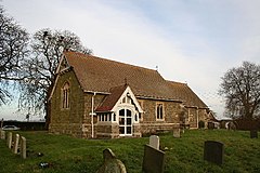
 St Wilfrid's Church, Thornton | |
Location within
Lincolnshire | |
| OS grid reference | TF245677 |
| • London | 120 mi (190 km) S |
| Civil parish | |
| District | |
| Shire county | |
| Region | |
| Country | England |
| Sovereign state | United Kingdom |
| Post town | Horncastle |
| Postcode district | LN9 |
| Police | Lincolnshire |
| Fire | Lincolnshire |
| Ambulance | East Midlands |
| UK Parliament | |
Thornton, or Thornton by Horncastle, is a village in the civil parish of Roughton, in the East Lindsey district of Lincolnshire, England. It is situated on the B1191 road, 1 mile (1.6 km) west from the A153, and 1.5 miles (2.4 km) south-west from Horncastle town centre. In 1971 the parish had a population of 57. [1] On 1 April 1987 the parish was abolished and merged with Roughton. [2]
The village is mentioned in the 1086 Domesday Book, with 19 households and Robert the Bursar as Lord of the Manor. [3]
The greenstone parish church is dedicated to Saint Wilfrid and is a Grade II listed building dating from the 15th century and restored in 1890 by Ewan Christian. [4]
- ^ "Population statistics Thornton AP/CP through time". A Vision of Britain through Time. Retrieved 22 November 2023.
- ^ "Horncastle Registration District". UKBMD. Retrieved 22 November 2023.
- ^ Thornton by Horncastle in the Domesday Book. Retrieved 19 June 2011.
- ^ Historic England. "St Wilfreds, Thornton (1262381)". National Heritage List for England. Retrieved 19 August 2011.
-
 Media related to
Thornton, Lincolnshire at Wikimedia Commons
| Thornton | |
|---|---|
 St Wilfrid's Church, Thornton | |
Location within
Lincolnshire | |
| OS grid reference | TF245677 |
| • London | 120 mi (190 km) S |
| Civil parish | |
| District | |
| Shire county | |
| Region | |
| Country | England |
| Sovereign state | United Kingdom |
| Post town | Horncastle |
| Postcode district | LN9 |
| Police | Lincolnshire |
| Fire | Lincolnshire |
| Ambulance | East Midlands |
| UK Parliament | |
Thornton, or Thornton by Horncastle, is a village in the civil parish of Roughton, in the East Lindsey district of Lincolnshire, England. It is situated on the B1191 road, 1 mile (1.6 km) west from the A153, and 1.5 miles (2.4 km) south-west from Horncastle town centre. In 1971 the parish had a population of 57. [1] On 1 April 1987 the parish was abolished and merged with Roughton. [2]
The village is mentioned in the 1086 Domesday Book, with 19 households and Robert the Bursar as Lord of the Manor. [3]
The greenstone parish church is dedicated to Saint Wilfrid and is a Grade II listed building dating from the 15th century and restored in 1890 by Ewan Christian. [4]
- ^ "Population statistics Thornton AP/CP through time". A Vision of Britain through Time. Retrieved 22 November 2023.
- ^ "Horncastle Registration District". UKBMD. Retrieved 22 November 2023.
- ^ Thornton by Horncastle in the Domesday Book. Retrieved 19 June 2011.
- ^ Historic England. "St Wilfreds, Thornton (1262381)". National Heritage List for England. Retrieved 19 August 2011.
-
 Media related to
Thornton, Lincolnshire at Wikimedia Commons
