Thorga | |
|---|---|
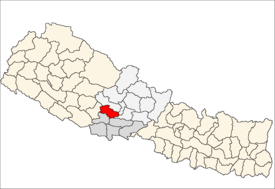
 Thorga village location in map of Nepal. | |
| Nickname: Origin of Thorga "Greeny VDC" | |
| Motto: Make Big Plans (Make No Small Plans) | |
| Country | |
| Region | Western |
| Zone | Lumbini |
| District | Gulmi |
| Settled | 2034 VS |
| Government | |
| • Type | Democratic |
| Population | |
| • Total | 1,150 |
| Time zone | NP |
| Website |
ddcgulmi |
Thorga is a village in Gulmi district, Lumbini Zone, Nepal. [1] It is mostly inhabited by Brahmins. The population of this village is around 1200 and literacy rate is about 35%.
Gulmi District
Gulmi District ( Nepali: गुल्मी जिल्ला), a part of Lumbini Zone, is one of the seventy-five districts of Nepal. The district, with Tamghas as its headquarters, covers an area of 1,149 km2, had a population of 296,654 in 2001 and 280,160 in 2011. [2]
Main features

It is renowned for coffee farming. People here depend upon agriculture and teaching occupation. In Agriculture, coffee & sugarcane are the main products.
Education institutes
- Shree Prativa Primary school
- Rainbow Boarding School
- Shree Rastriya Higher secondary school
See also
References
- ^ Sharma, Chandra K. (1979). Nepal and the Nepalese. Sangeeta Sharma. p. 150. OCLC 7999374.
- ^ "National Population and Housing Census 2011(National Report)" (PDF). Central Bureau of Statistics. Government of Nepal. November 2012. Archived from the original (PDF) on 2013-04-18. Retrieved December 21, 2015.
Thorga | |
|---|---|
 Thorga village location in map of Nepal. | |
| Nickname: Origin of Thorga "Greeny VDC" | |
| Motto: Make Big Plans (Make No Small Plans) | |
| Country | |
| Region | Western |
| Zone | Lumbini |
| District | Gulmi |
| Settled | 2034 VS |
| Government | |
| • Type | Democratic |
| Population | |
| • Total | 1,150 |
| Time zone | NP |
| Website |
ddcgulmi |
Thorga is a village in Gulmi district, Lumbini Zone, Nepal. [1] It is mostly inhabited by Brahmins. The population of this village is around 1200 and literacy rate is about 35%.
Gulmi District
Gulmi District ( Nepali: गुल्मी जिल्ला), a part of Lumbini Zone, is one of the seventy-five districts of Nepal. The district, with Tamghas as its headquarters, covers an area of 1,149 km2, had a population of 296,654 in 2001 and 280,160 in 2011. [2]
Main features

It is renowned for coffee farming. People here depend upon agriculture and teaching occupation. In Agriculture, coffee & sugarcane are the main products.
Education institutes
- Shree Prativa Primary school
- Rainbow Boarding School
- Shree Rastriya Higher secondary school
See also
References
- ^ Sharma, Chandra K. (1979). Nepal and the Nepalese. Sangeeta Sharma. p. 150. OCLC 7999374.
- ^ "National Population and Housing Census 2011(National Report)" (PDF). Central Bureau of Statistics. Government of Nepal. November 2012. Archived from the original (PDF) on 2013-04-18. Retrieved December 21, 2015.