Photos • Location

The Lower Red Lion
From Wikipedia, the free encyclopedia

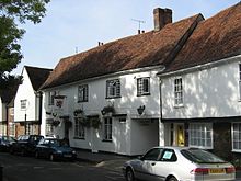
The Lower Red Lion is a public house at 34 and 36 Fishpool Street in St Albans, Hertfordshire, England. The building is seventeenth century and is designated Grade II with Historic England. [1]
References
- ^ Historic England. "THE LOWER RED LION (1103142)". National Heritage List for England. Retrieved 20 August 2016.
Pubs in
Hertfordshire | |
|---|---|
| Dacorum | |
| East Hertfordshire | |
| Hertsmere | |
| St Albans | |
| Welwyn Hatfield | |
51°45′06″N 0°20′47″W / 51.7517°N 0.3465°W / 51.7517; -0.3465
|
| This article about a Hertfordshire building or structure is a stub. You can help Wikipedia by expanding it. |
Retrieved from "
https://en.wikipedia.org/?title=The_Lower_Red_Lion&oldid=1220035903"
From Wikipedia, the free encyclopedia

The Lower Red Lion is a public house at 34 and 36 Fishpool Street in St Albans, Hertfordshire, England. The building is seventeenth century and is designated Grade II with Historic England. [1]
References
- ^ Historic England. "THE LOWER RED LION (1103142)". National Heritage List for England. Retrieved 20 August 2016.
Pubs in
Hertfordshire | |
|---|---|
| Dacorum | |
| East Hertfordshire | |
| Hertsmere | |
| St Albans | |
| Welwyn Hatfield | |
Listed buildings in
Hertfordshire | |||||||||||||||||||||||||
|---|---|---|---|---|---|---|---|---|---|---|---|---|---|---|---|---|---|---|---|---|---|---|---|---|---|
| |||||||||||||||||||||||||
| |||||||||||||||||||||||||
| |||||||||||||||||||||||||
51°45′06″N 0°20′47″W / 51.7517°N 0.3465°W / 51.7517; -0.3465
|
| This article about a Hertfordshire building or structure is a stub. You can help Wikipedia by expanding it. |
Retrieved from "
https://en.wikipedia.org/?title=The_Lower_Red_Lion&oldid=1220035903"