| The Gums Queensland | |||||||||||||||
|---|---|---|---|---|---|---|---|---|---|---|---|---|---|---|---|
 The Gums | |||||||||||||||
| Coordinates | 27°20′25″S 150°12′18″E / 27.3402°S 150.205°E | ||||||||||||||
| Population | 165 ( 2021 census) [1] | ||||||||||||||
| • Density | 0.1522/km2 (0.3941/sq mi) | ||||||||||||||
| Postcode(s) | 4406 | ||||||||||||||
| Area | 1,084.4 km2 (418.7 sq mi) | ||||||||||||||
| Time zone | AEST ( UTC+10:00) | ||||||||||||||
| Location | |||||||||||||||
| LGA(s) | Western Downs Region | ||||||||||||||
| State electorate(s) | Warrego | ||||||||||||||
| Federal division(s) | Maranoa | ||||||||||||||
| |||||||||||||||
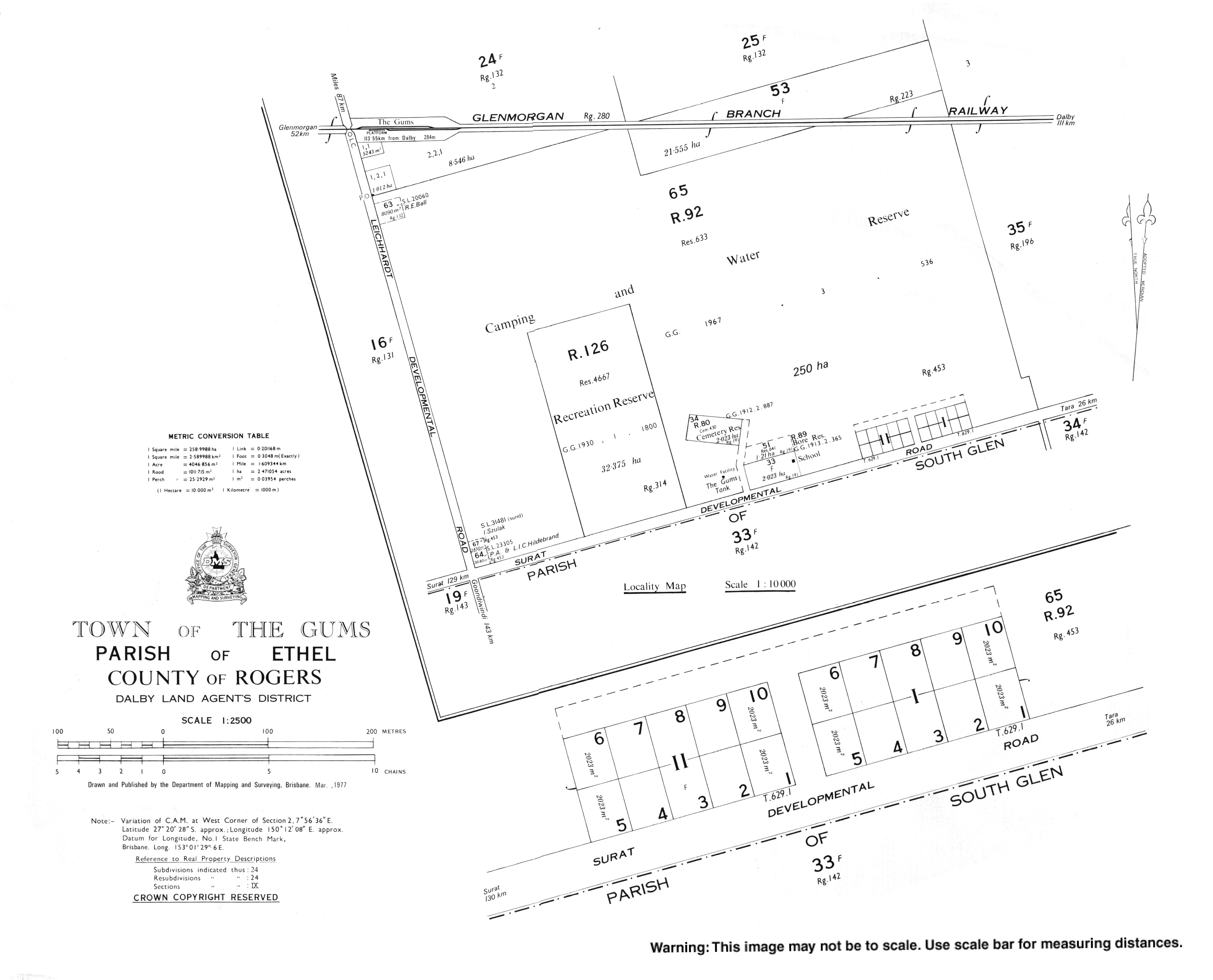
The Gums is a rural town and locality in the Western Downs Region, Queensland, Australia. [2] [3] In the 2021 census, the locality of The Gums had a population of 165 people. [1]
The town is at the junction of the Leichhardt Highway and the Surat Developmental Road [4] on the Darling Downs, 329 kilometres (204 mi) west of the state capital, Brisbane.
The Glenmorgan railway line passes through the locality from east ( Tara) to west ( Hannaford). In 2017, there were three stations serving the locality: The Gums railway station (which is north of but close to the town, 27°19′43″S 150°11′07″E / 27.3286°S 150.1853°E), [5] Cabawin railway station ( 27°19′46″S 150°15′01″E / 27.3294°S 150.2503°E), [6] and South Glen railway station ( 27°18′19″S 150°19′00″E / 27.3053°S 150.3167°E). [7] However, in 2019, only The Gums railway station is listed as still operational. [8]
The name of the town was derived from The Gums railway station, on the Glenmorgan railway line from Dalby to Glenmorgan, [9] used from 1924. [2] [3]
South Glen Provisional School opened in 1913 and closed circa 1921. [10]
The Gums State School opened on 27 January 1913. [10]
In 1914 a Methodist church was built at The Gums. [11]
Cabawin Provisional School opened on 30 January 1934. In 1952 it became Cabawin State School. It closed in 1960. [10] It was on Cabawin South Road ( 27°21′52″S 150°15′30″E / 27.3644°S 150.2582°E). [12]
In the 2006 census, the locality of The Gums and the surrounding area had a population of 169 people. [13]
In the 2016 census, the locality of The Gums had a population of 159 people. [14]
In the 2021 census, the locality of The Gums had a population of 165 people. [1]

The Gums State School is a government primary (Prep-6) school for boys and girls at 12051 Surat Developmental Road ( 27°20′29″S 150°11′58″E / 27.3414°S 150.1994°E). [15] [16] In 2017, the school had an enrolment of 22 students with 4 teachers (2 full-time equivalent) and 5 non-teaching staff (2 full-time equivalent). [17]
There is no secondary school in The Gums. The nearest secondary school is Tara Shire State College in Tara. [18]


The Gums has a small cemetery ( 27°20′21″S 150°11′46″E / 27.3393°S 150.1960°E). One of the headstones is for the first headmaster of The Gums State School, Alexander Davison who died on 7 November 1916.
- ^ a b c Australian Bureau of Statistics (28 June 2022). "The Gums (SAL)". 2021 Census QuickStats. Retrieved 28 February 2023.
- ^ a b "The Gums – town in Western Downs Region (entry 33961)". Queensland Place Names. Queensland Government. Retrieved 27 January 2020.
- ^ a b "The Gums – locality in Western Downs Region (entry 47751)". Queensland Place Names. Queensland Government. Retrieved 27 January 2020.
- ^ "The Gums". australianexplorer.com. Archived from the original on 6 March 2012. Retrieved 15 October 2010.
- ^ "The Gums – railway station in the Western Down Region (entry 33962)". Queensland Place Names. Queensland Government. Retrieved 25 December 2017.
- ^ "Cabawin – railway station in the Western Downs Region (entry 5606)". Queensland Place Names. Queensland Government. Retrieved 26 December 2017.
- ^ "South Glen – railway station in the Western Downs Region (entry 31458)". Queensland Place Names. Queensland Government. Retrieved 25 December 2017.
- ^ "Queensland Globe". State of Queensland. Retrieved 6 June 2019.
- ^ "Location Profiles - Darling Downs-West Moreton Health Service District - GLENMORGAN". Queensland Government. 23 February 2010. Archived from the original on 20 March 2011. Retrieved 17 October 2010.
- ^ a b c Queensland Family History Society (2010), Queensland schools past and present (Version 1.01 ed.), Queensland Family History Society, ISBN 978-1-921171-26-0
- ^ "METHODIST SYNODS". The Brisbane Courier. No. 17, 721. Queensland, Australia. 31 October 1914. p. 16. Retrieved 10 September 2021 – via National Library of Australia.
- ^ "Queensland Two Mile series sheet 2m48" (Map). Queensland Government. 1955. Archived from the original on 24 April 2020. Retrieved 25 April 2020.
- ^ Australian Bureau of Statistics (25 October 2007). "The Gums (Tara Shire) (State Suburb)". 2006 Census QuickStats. Retrieved 4 November 2008.
- ^ Australian Bureau of Statistics (27 June 2017). "The Gums (SSC)". 2016 Census QuickStats. Retrieved 20 October 2018.
- ^ "State and non-state school details". Queensland Government. 9 July 2018. Archived from the original on 21 November 2018. Retrieved 21 November 2018.
- ^ "The Gums State School". The Gums State School. 29 November 2020. Retrieved 28 September 2023.
- ^ "ACARA School Profile 2017". Archived from the original on 22 November 2018. Retrieved 22 November 2018.
- ^ "Queensland Globe". State of Queensland. Retrieved 24 April 2020.
| The Gums Queensland | |||||||||||||||
|---|---|---|---|---|---|---|---|---|---|---|---|---|---|---|---|
The Gums | |||||||||||||||
| Coordinates | 27°20′25″S 150°12′18″E / 27.3402°S 150.205°E | ||||||||||||||
| Population | 165 ( 2021 census) [1] | ||||||||||||||
| • Density | 0.1522/km2 (0.3941/sq mi) | ||||||||||||||
| Postcode(s) | 4406 | ||||||||||||||
| Area | 1,084.4 km2 (418.7 sq mi) | ||||||||||||||
| Time zone | AEST ( UTC+10:00) | ||||||||||||||
| Location | |||||||||||||||
| LGA(s) | Western Downs Region | ||||||||||||||
| State electorate(s) | Warrego | ||||||||||||||
| Federal division(s) | Maranoa | ||||||||||||||
| |||||||||||||||
The Gums is a rural town and locality in the Western Downs Region, Queensland, Australia. [2] [3] In the 2021 census, the locality of The Gums had a population of 165 people. [1]
The town is at the junction of the Leichhardt Highway and the Surat Developmental Road [4] on the Darling Downs, 329 kilometres (204 mi) west of the state capital, Brisbane.
The Glenmorgan railway line passes through the locality from east ( Tara) to west ( Hannaford). In 2017, there were three stations serving the locality: The Gums railway station (which is north of but close to the town, 27°19′43″S 150°11′07″E / 27.3286°S 150.1853°E), [5] Cabawin railway station ( 27°19′46″S 150°15′01″E / 27.3294°S 150.2503°E), [6] and South Glen railway station ( 27°18′19″S 150°19′00″E / 27.3053°S 150.3167°E). [7] However, in 2019, only The Gums railway station is listed as still operational. [8]
The name of the town was derived from The Gums railway station, on the Glenmorgan railway line from Dalby to Glenmorgan, [9] used from 1924. [2] [3]
South Glen Provisional School opened in 1913 and closed circa 1921. [10]
The Gums State School opened on 27 January 1913. [10]
In 1914 a Methodist church was built at The Gums. [11]
Cabawin Provisional School opened on 30 January 1934. In 1952 it became Cabawin State School. It closed in 1960. [10] It was on Cabawin South Road ( 27°21′52″S 150°15′30″E / 27.3644°S 150.2582°E). [12]
In the 2006 census, the locality of The Gums and the surrounding area had a population of 169 people. [13]
In the 2016 census, the locality of The Gums had a population of 159 people. [14]
In the 2021 census, the locality of The Gums had a population of 165 people. [1]
The Gums State School is a government primary (Prep-6) school for boys and girls at 12051 Surat Developmental Road ( 27°20′29″S 150°11′58″E / 27.3414°S 150.1994°E). [15] [16] In 2017, the school had an enrolment of 22 students with 4 teachers (2 full-time equivalent) and 5 non-teaching staff (2 full-time equivalent). [17]
There is no secondary school in The Gums. The nearest secondary school is Tara Shire State College in Tara. [18]
The Gums has a small cemetery ( 27°20′21″S 150°11′46″E / 27.3393°S 150.1960°E). One of the headstones is for the first headmaster of The Gums State School, Alexander Davison who died on 7 November 1916.
- ^ a b c Australian Bureau of Statistics (28 June 2022). "The Gums (SAL)". 2021 Census QuickStats. Retrieved 28 February 2023.
- ^ a b "The Gums – town in Western Downs Region (entry 33961)". Queensland Place Names. Queensland Government. Retrieved 27 January 2020.
- ^ a b "The Gums – locality in Western Downs Region (entry 47751)". Queensland Place Names. Queensland Government. Retrieved 27 January 2020.
- ^ "The Gums". australianexplorer.com. Archived from the original on 6 March 2012. Retrieved 15 October 2010.
- ^ "The Gums – railway station in the Western Down Region (entry 33962)". Queensland Place Names. Queensland Government. Retrieved 25 December 2017.
- ^ "Cabawin – railway station in the Western Downs Region (entry 5606)". Queensland Place Names. Queensland Government. Retrieved 26 December 2017.
- ^ "South Glen – railway station in the Western Downs Region (entry 31458)". Queensland Place Names. Queensland Government. Retrieved 25 December 2017.
- ^ "Queensland Globe". State of Queensland. Retrieved 6 June 2019.
- ^ "Location Profiles - Darling Downs-West Moreton Health Service District - GLENMORGAN". Queensland Government. 23 February 2010. Archived from the original on 20 March 2011. Retrieved 17 October 2010.
- ^ a b c Queensland Family History Society (2010), Queensland schools past and present (Version 1.01 ed.), Queensland Family History Society, ISBN 978-1-921171-26-0
- ^ "METHODIST SYNODS". The Brisbane Courier. No. 17, 721. Queensland, Australia. 31 October 1914. p. 16. Retrieved 10 September 2021 – via National Library of Australia.
- ^ "Queensland Two Mile series sheet 2m48" (Map). Queensland Government. 1955. Archived from the original on 24 April 2020. Retrieved 25 April 2020.
- ^ Australian Bureau of Statistics (25 October 2007). "The Gums (Tara Shire) (State Suburb)". 2006 Census QuickStats. Retrieved 4 November 2008.
- ^ Australian Bureau of Statistics (27 June 2017). "The Gums (SSC)". 2016 Census QuickStats. Retrieved 20 October 2018.
- ^ "State and non-state school details". Queensland Government. 9 July 2018. Archived from the original on 21 November 2018. Retrieved 21 November 2018.
- ^ "The Gums State School". The Gums State School. 29 November 2020. Retrieved 28 September 2023.
- ^ "ACARA School Profile 2017". Archived from the original on 22 November 2018. Retrieved 22 November 2018.
- ^ "Queensland Globe". State of Queensland. Retrieved 24 April 2020.