Photos • Location
Thacker Mines | |
|---|---|

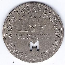
Coal scrip from Thacker Mines, West Virginia | |
| Coordinates: 37°36′13″N 82°5′48″W / 37.60361°N 82.09667°W | |
| Country | United States |
| State | West Virginia |
| County | Mingo |
| Elevation | 974 ft (297 m) |
| Time zone | UTC-5 ( Eastern (EST)) |
| • Summer ( DST) | UTC-4 (EDT) |
| FIPS code | 1555797 [1] |
Thacker Mines is an unincorporated community and coal town located in Mingo County, West Virginia. Their post office [2] has been closed.
References
Thacker Mines | |
|---|---|

Coal scrip from Thacker Mines, West Virginia | |
| Coordinates: 37°36′13″N 82°5′48″W / 37.60361°N 82.09667°W | |
| Country | United States |
| State | West Virginia |
| County | Mingo |
| Elevation | 974 ft (297 m) |
| Time zone | UTC-5 ( Eastern (EST)) |
| • Summer ( DST) | UTC-4 (EDT) |
| FIPS code | 1555797 [1] |
Thacker Mines is an unincorporated community and coal town located in Mingo County, West Virginia. Their post office [2] has been closed.
References

