The bridge was constructed in the 14th or 15th century and comprises six arches of various heights and widths, the middle three of which span the river.[1]
Three of the arches were rebuilt at the beginning of the 19th century and the parapet may also have been rebuilt. The bridge is a Grade I
listed building and a
scheduled ancient monument.[1][2]
Description
Teston Bridge is built of
coursedrag-stone with
ashlar capping stones to the parapets. The bridge is narrow, only wide enough to permit traffic to pass in one direction at a time and the parapets feature pedestrian refuges continued up from the
cutwaters on each side.[1] It carries the B2163 road, which is crossed
on the level by the
Medway Valley Line just west of the bridge. The crossing was the site of
Teston Crossing Halt,[3] which was open from 1909 to 1959.[4]

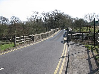 Looking south-east across the bridge


