Terranova | |
|---|---|
Barrio | |
 Lookout in Terranova | |
 Location of Terranova within the municipality of Quebradillas shown in red | |
 Terranova Location of Puerto Rico | |
| Coordinates: 18°29′21″N 66°56′17″W / 18.489081°N 66.937987°W [1] | |
| Commonwealth | |
| Municipality | |
| Area | |
| • Total | 2.98 sq mi (7.7 km2) |
| • Land | 2.41 sq mi (6.2 km2) |
| • Water | 0.57 sq mi (1.5 km2) |
| Elevation | 302 ft (92 m) |
| Population (2010) | |
| • Total | 3,102 |
| • Density | 1,287.1/sq mi (497.0/km2) |
| Source: 2010 Census | |
| Time zone | UTC−4 ( AST) |
Terranova is a barrio in the municipality of Quebradillas, Puerto Rico. Its population in 2010 was 3,102. [3] [4] [5]
| Census | Pop. | Note | %± |
|---|---|---|---|
| 1900 | 779 | — | |
| 1910 | 789 | 1.3% | |
| 1920 | 995 | 26.1% | |
| 1930 | 996 | 0.1% | |
| 1940 | 1,423 | 42.9% | |
| 1950 | 1,618 | 13.7% | |
| 1960 | 1,382 | −14.6% | |
| 1970 | 0 | −100.0% | |
| 1980 | 3,298 | — | |
| 1990 | 3,592 | 8.9% | |
| 2000 | 3,841 | 6.9% | |
| 2010 | 3,102 | −19.2% | |
| U.S. Decennial Census 1899 (shown as 1900) [6] 1910-1930 [7] 1930-1950 [8] 1980-2000 [9] 2010 [10] | |||
History
Terranova was in Spain's gazetteers [11] until Puerto Rico was ceded by Spain in the aftermath of the Spanish–American War under the terms of the Treaty of Paris of 1898 and became an unincorporated territory of the United States. In 1899, the United States Department of War conducted a census of Puerto Rico finding that the population of Terranova barrio was 779. [12]
Sectors
Barrios (which are, in contemporary times, roughly comparable to minor civil divisions) [13] in turn are further subdivided into smaller local populated place areas/units called sectores (sectors in English). The types of sectores may vary, from normally sector to urbanización to reparto to barriada to residencial, among others. [14] [15] [16] [17] [18]
The following sectors are in Terranova barrio: [19]
Calle Coliseo, Calle del Parque, Calle Las Flores, Camino Amador, Carretera 113, Carretera 477, Parcelas Terranova, Reparto Muñoz, Residencial Guarionex, Sector Estación, Sector Juan González, Sector Las Cuevitas, Sector Los Barros, Sector Los Prietos, Sector Quebrada Mala, Sector Rábano, Sector Villa Durán, Sector Villa Varguitas, and Urbanización San Rafael.
Gallery
-
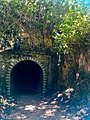 Túnel Negro in Terranova
 -
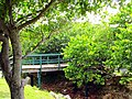
 Recreational area in Terranova
 -
 Recreational area in Terranova
 -
 Bridge in Terranova
 -
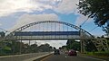 Puerto Rico Highway 2 in Terranova

.jpg)
.jpg)


See also
References
- ^ a b "US Gazetteer 2019". US Census. US Government.
- ^ U.S. Geological Survey Geographic Names Information System: Terranova barrio
- ^ Picó, Rafael; Buitrago de Santiago, Zayda; Berrios, Hector H. Nueva geografía de Puerto Rico: física, económica, y social, por Rafael Picó. Con la colaboración de Zayda Buitrago de Santiago y Héctor H. Berrios. San Juan Editorial Universitaria, Universidad de Puerto Rico,1969.
- ^ Gwillim Law (20 May 2015). Administrative Subdivisions of Countries: A Comprehensive World Reference, 1900 through 1998. McFarland. p. 300. ISBN 978-1-4766-0447-3. Retrieved 25 December 2018.
- ^ Puerto Rico: 2010 Population and Housing Unit Counts.pdf (PDF). U.S. Dept. of Commerce, Economics and Statistics Administration, U.S. Census Bureau. 2010.
- ^ "Report of the Census of Porto Rico 1899". War Department Office Director Census of Porto Rico. Archived from the original on July 16, 2017. Retrieved September 21, 2017.
- ^ "Table 3-Population of Municipalities: 1930 1920 and 1910" (PDF). United States Census Bureau. Archived (PDF) from the original on August 17, 2017. Retrieved September 21, 2017.
- ^ "Table 4-Area and Population of Municipalities Urban and Rural: 1930 to 1950" (PDF). United States Census Bureau. Archived (PDF) from the original on August 30, 2015. Retrieved September 21, 2014.
- ^ "Table 2 Population and Housing Units: 1960 to 2000" (PDF). United States Census Bureau. Archived (PDF) from the original on July 24, 2017. Retrieved September 21, 2017.
- ^ Puerto Rico: 2010 Population and Housing Unit Counts.pdf (PDF). U.S. Dept. of Commerce Economics and Statistics Administration U.S. Census Bureau. 2010. Archived (PDF) from the original on 2017-02-20. Retrieved 2019-08-02.
- ^ "Anuario del comercio, de la industria, de la magistratura y de la administración. 1881". Biblioteca Nacional de España (in Spanish). p. 1614. Retrieved 4 April 2023.
- ^ Joseph Prentiss Sanger; Henry Gannett; Walter Francis Willcox (1900). Informe sobre el censo de Puerto Rico, 1899, United States. War Dept. Porto Rico Census Office (in Spanish). Imprenta del gobierno. p. 161.
- ^ "US Census Barrio-Pueblo definition". factfinder.com. US Census. Archived from the original on 13 May 2017. Retrieved 5 January 2019.
- ^ Mari Mut, José A. (28 August 2013). "Los pueblos de Puerto Rico y las iglesias de sus plazas" (in Spanish). Retrieved 19 June 2020 – via archive.org.
- ^ "Agencia: Oficina del Coordinador General para el Financiamiento Socioeconómico y la Autogestión (Proposed 2016 Budget)". Puerto Rico Budgets (in Spanish). Retrieved 28 June 2019.
- ^ Rivera Quintero, Marcia (2014), El vuelo de la esperanza : Proyecto de las Comunidades Especiales Puerto Rico, 1997-2004 (Primera edición ed.), San Juan, Puerto Rico Fundación Sila M. Calderón, ISBN 978-0-9820806-1-0
- ^ "Leyes del 2001". Lex Juris Puerto Rico (in Spanish). Retrieved 24 June 2019.
- ^ "Comunidades Especiales de Puerto Rico" (in Spanish). 8 August 2011. Retrieved 24 June 2019.
- ^ "PRECINTO ELECTORAL QUEBRADILLAS 031" (PDF). Comisión Estatal de Elecciones (in Spanish). PR Government. 21 September 2019. Retrieved 26 July 2020.
|
| This Quebradillas, Puerto Rico location article is a stub. You can help Wikipedia by expanding it. |
Terranova | |
|---|---|
Barrio | |
|
Lookout in Terranova | |
|
Location of Terranova within the municipality of Quebradillas shown in red | |
Terranova Location of Puerto Rico | |
| Coordinates: 18°29′21″N 66°56′17″W / 18.489081°N 66.937987°W [1] | |
| Commonwealth | |
| Municipality | |
| Area | |
| • Total | 2.98 sq mi (7.7 km2) |
| • Land | 2.41 sq mi (6.2 km2) |
| • Water | 0.57 sq mi (1.5 km2) |
| Elevation | 302 ft (92 m) |
| Population (2010) | |
| • Total | 3,102 |
| • Density | 1,287.1/sq mi (497.0/km2) |
| Source: 2010 Census | |
| Time zone | UTC−4 ( AST) |
Terranova is a barrio in the municipality of Quebradillas, Puerto Rico. Its population in 2010 was 3,102. [3] [4] [5]
| Census | Pop. | Note | %± |
|---|---|---|---|
| 1900 | 779 | — | |
| 1910 | 789 | 1.3% | |
| 1920 | 995 | 26.1% | |
| 1930 | 996 | 0.1% | |
| 1940 | 1,423 | 42.9% | |
| 1950 | 1,618 | 13.7% | |
| 1960 | 1,382 | −14.6% | |
| 1970 | 0 | −100.0% | |
| 1980 | 3,298 | — | |
| 1990 | 3,592 | 8.9% | |
| 2000 | 3,841 | 6.9% | |
| 2010 | 3,102 | −19.2% | |
| U.S. Decennial Census 1899 (shown as 1900) [6] 1910-1930 [7] 1930-1950 [8] 1980-2000 [9] 2010 [10] | |||
History
Terranova was in Spain's gazetteers [11] until Puerto Rico was ceded by Spain in the aftermath of the Spanish–American War under the terms of the Treaty of Paris of 1898 and became an unincorporated territory of the United States. In 1899, the United States Department of War conducted a census of Puerto Rico finding that the population of Terranova barrio was 779. [12]
Sectors
Barrios (which are, in contemporary times, roughly comparable to minor civil divisions) [13] in turn are further subdivided into smaller local populated place areas/units called sectores (sectors in English). The types of sectores may vary, from normally sector to urbanización to reparto to barriada to residencial, among others. [14] [15] [16] [17] [18]
The following sectors are in Terranova barrio: [19]
Calle Coliseo, Calle del Parque, Calle Las Flores, Camino Amador, Carretera 113, Carretera 477, Parcelas Terranova, Reparto Muñoz, Residencial Guarionex, Sector Estación, Sector Juan González, Sector Las Cuevitas, Sector Los Barros, Sector Los Prietos, Sector Quebrada Mala, Sector Rábano, Sector Villa Durán, Sector Villa Varguitas, and Urbanización San Rafael.
Gallery
-
Túnel Negro in Terranova
-
Recreational area in Terranova
-
Recreational area in Terranova
-
Bridge in Terranova
-
Puerto Rico Highway 2 in Terranova
See also
References
- ^ a b "US Gazetteer 2019". US Census. US Government.
- ^ U.S. Geological Survey Geographic Names Information System: Terranova barrio
- ^ Picó, Rafael; Buitrago de Santiago, Zayda; Berrios, Hector H. Nueva geografía de Puerto Rico: física, económica, y social, por Rafael Picó. Con la colaboración de Zayda Buitrago de Santiago y Héctor H. Berrios. San Juan Editorial Universitaria, Universidad de Puerto Rico,1969.
- ^ Gwillim Law (20 May 2015). Administrative Subdivisions of Countries: A Comprehensive World Reference, 1900 through 1998. McFarland. p. 300. ISBN 978-1-4766-0447-3. Retrieved 25 December 2018.
- ^ Puerto Rico: 2010 Population and Housing Unit Counts.pdf (PDF). U.S. Dept. of Commerce, Economics and Statistics Administration, U.S. Census Bureau. 2010.
- ^ "Report of the Census of Porto Rico 1899". War Department Office Director Census of Porto Rico. Archived from the original on July 16, 2017. Retrieved September 21, 2017.
- ^ "Table 3-Population of Municipalities: 1930 1920 and 1910" (PDF). United States Census Bureau. Archived (PDF) from the original on August 17, 2017. Retrieved September 21, 2017.
- ^ "Table 4-Area and Population of Municipalities Urban and Rural: 1930 to 1950" (PDF). United States Census Bureau. Archived (PDF) from the original on August 30, 2015. Retrieved September 21, 2014.
- ^ "Table 2 Population and Housing Units: 1960 to 2000" (PDF). United States Census Bureau. Archived (PDF) from the original on July 24, 2017. Retrieved September 21, 2017.
- ^ Puerto Rico: 2010 Population and Housing Unit Counts.pdf (PDF). U.S. Dept. of Commerce Economics and Statistics Administration U.S. Census Bureau. 2010. Archived (PDF) from the original on 2017-02-20. Retrieved 2019-08-02.
- ^ "Anuario del comercio, de la industria, de la magistratura y de la administración. 1881". Biblioteca Nacional de España (in Spanish). p. 1614. Retrieved 4 April 2023.
- ^ Joseph Prentiss Sanger; Henry Gannett; Walter Francis Willcox (1900). Informe sobre el censo de Puerto Rico, 1899, United States. War Dept. Porto Rico Census Office (in Spanish). Imprenta del gobierno. p. 161.
- ^ "US Census Barrio-Pueblo definition". factfinder.com. US Census. Archived from the original on 13 May 2017. Retrieved 5 January 2019.
- ^ Mari Mut, José A. (28 August 2013). "Los pueblos de Puerto Rico y las iglesias de sus plazas" (in Spanish). Retrieved 19 June 2020 – via archive.org.
- ^ "Agencia: Oficina del Coordinador General para el Financiamiento Socioeconómico y la Autogestión (Proposed 2016 Budget)". Puerto Rico Budgets (in Spanish). Retrieved 28 June 2019.
- ^ Rivera Quintero, Marcia (2014), El vuelo de la esperanza : Proyecto de las Comunidades Especiales Puerto Rico, 1997-2004 (Primera edición ed.), San Juan, Puerto Rico Fundación Sila M. Calderón, ISBN 978-0-9820806-1-0
- ^ "Leyes del 2001". Lex Juris Puerto Rico (in Spanish). Retrieved 24 June 2019.
- ^ "Comunidades Especiales de Puerto Rico" (in Spanish). 8 August 2011. Retrieved 24 June 2019.
- ^ "PRECINTO ELECTORAL QUEBRADILLAS 031" (PDF). Comisión Estatal de Elecciones (in Spanish). PR Government. 21 September 2019. Retrieved 26 July 2020.
|
| This Quebradillas, Puerto Rico location article is a stub. You can help Wikipedia by expanding it. |