Photos • Location
| Tenderfoot Pass | |
|---|---|
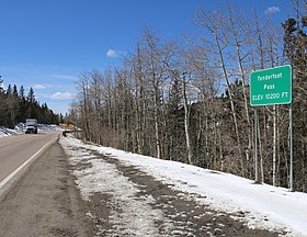
 The pass and
Highway 67 | |
| Elevation | 10,200 ft (3,109 m) |
| Traversed by | |
| Location |
Teller County,
Colorado United States |
| Range | Front Range |
| Coordinates | 38°45′46″N 105°09′23″W / 38.76278°N 105.15639°W |
Tenderfoot Pass is a mountain pass northeast of Cripple Creek that reaches a peak elevation of 10,200 feet (3,100 m).
See also
External links
| Tenderfoot Pass | |
|---|---|
 The pass and
Highway 67 | |
| Elevation | 10,200 ft (3,109 m) |
| Traversed by | |
| Location |
Teller County,
Colorado United States |
| Range | Front Range |
| Coordinates | 38°45′46″N 105°09′23″W / 38.76278°N 105.15639°W |
Tenderfoot Pass is a mountain pass northeast of Cripple Creek that reaches a peak elevation of 10,200 feet (3,100 m).
