PhotosLocation


template+infobox+uk+place+testcases Latitude and Longitude:

51°45′32″N 1°16′05″W / 51.759°N 1.268°W / 51.759; -1.268
From Wikipedia, the free encyclopedia


Proposed Changes by Keith D (places added to cover areas)

Side by side comparison
{{ Infobox UK place}}{{ Infobox UK place/sandbox}}
Maidstone
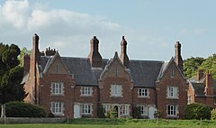
A stone built house with red-tiled roof, overlooking a river. Behind a blue sky with white clouds.
Testing image alternate text
River and Archbishop's Palace, Maidstone.
without image alternate text
River and Archbishop's Palace, Maidstone.
Located just northwest of the centre of Kent, which is in the southeast of England.
Maidstone
Location within Kent
Area100 sq mi (260 km2)
Population75,070 (2001)
•  Density751/sq mi (290/km2)
OS grid reference TQ765555
•  London32 mi (51 km)  NW
District
Shire county
Region
Country England
Sovereign stateUnited Kingdom
Places
Post townmaidstone (in lower case)
Postcode district ME14-ME18
Dialling code01622
Police Kent
Fire Kent
Ambulance South East Coast
UK Parliament
Website www.greatermanchester.gov.uk/home.html
List of places
UK
England
Kent
51°16′N 0°32′E / 51.27°N 0.53°E / 51.27; 0.53
Maidstone
A stone built house with red-tiled roof, overlooking a river. Behind a blue sky with white clouds.
Testing image alternate text
River and Archbishop's Palace, Maidstone.
without image alternate text
River and Archbishop's Palace, Maidstone.
Located just northwest of the centre of Kent, which is in the southeast of England.
Maidstone
Location within Kent
Area100 sq mi (260 km2)
Population75,070 (2001)
•  Density751/sq mi (290/km2)
OS grid reference TQ765555
•  London32 mi (51 km)  NW
District
Shire county
Region
Country England
Sovereign stateUnited Kingdom
Places
Post townmaidstone (in lower case)
Postcode district ME14-ME18
Dialling code01622
Police Kent
Fire Kent
Ambulance South East Coast
UK Parliament
Website www.greatermanchester.gov.uk/home.html
List of places
UK
England
Kent
51°16′N 0°32′E / 51.27°N 0.53°E / 51.27; 0.53

Proposed Changes by Bellezzasolo (with custom map caption)

Side by side comparison
{{ Infobox UK place}}{{ Infobox UK place/sandbox}}
Jericho
Jericho and the tower of St Barnabas Church seen from the Oxford Canal
Jericho is located in Oxford
Jericho
Jericho
Jericho shown within Oxford
Jericho is located in Oxfordshire
Jericho
Jericho
Location within Oxfordshire
OS grid reference SP504069
Civil parish
  • unparished
District
Shire county
Region
Country England
Sovereign stateUnited Kingdom
Post town Oxford
Postcode district OX2
Dialling code01865
Police Thames Valley
Fire Oxfordshire
Ambulance South Central
UK Parliament
Website Oxford City Council
List of places
UK
England
Oxfordshire
51°45′32″N 1°16′05″W / 51.759°N 1.268°W / 51.759; -1.268
Jericho
Jericho and the tower of St Barnabas Church seen from the Oxford Canal
Jericho is located in Oxford
Jericho
Jericho
Jericho shown within Oxford
Jericho is located in Oxfordshire
Jericho
Jericho
Location within Oxfordshire
OS grid reference SP504069
Civil parish
  • unparished
District
Shire county
Region
Country England
Sovereign stateUnited Kingdom
Post town Oxford
Postcode district OX2
Dialling code01865
Police Thames Valley
Fire Oxfordshire
Ambulance South Central
UK Parliament
Website Oxford City Council
List of places
UK
England
Oxfordshire
51°45′32″N 1°16′05″W / 51.759°N 1.268°W / 51.759; -1.268

England ( Maidstone)

Side by side comparison
{{ Infobox UK place}}{{ Infobox UK place/sandbox}}
Maidstone
A stone built house with red-tiled roof, overlooking a river. Behind a blue sky with white clouds.
Testing image alternate text
River and Archbishop's Palace, Maidstone.
without image alternate text
River and Archbishop's Palace, Maidstone.
Located just northwest of the centre of Kent, which is in the southeast of England.
Maidstone
Location within Kent
Area100 sq mi (260 km2)
Population75,070 (2001)
•  Density751/sq mi (290/km2)
OS grid reference TQ765555
•  London32 mi (51 km)  NW
District
Shire county
Region
Country England
Sovereign stateUnited Kingdom
Post townmaidstone (in lower case)
Postcode district ME14-ME18
Dialling code01622
Police Kent
Fire Kent
Ambulance South East Coast
UK Parliament
Website www.greatermanchester.gov.uk/home.html
List of places
UK
England
Kent
51°16′N 0°32′E / 51.27°N 0.53°E / 51.27; 0.53
Maidstone
A stone built house with red-tiled roof, overlooking a river. Behind a blue sky with white clouds.
Testing image alternate text
River and Archbishop's Palace, Maidstone.
without image alternate text
River and Archbishop's Palace, Maidstone.
Located just northwest of the centre of Kent, which is in the southeast of England.
Maidstone
Location within Kent
Area100 sq mi (260 km2)
Population75,070 (2001)
•  Density751/sq mi (290/km2)
OS grid reference TQ765555
•  London32 mi (51 km)  NW
District
Shire county
Region
Country England
Sovereign stateUnited Kingdom
Post townmaidstone (in lower case)
Postcode district ME14-ME18
Dialling code01622
Police Kent
Fire Kent
Ambulance South East Coast
UK Parliament
Website www.greatermanchester.gov.uk/home.html
List of places
UK
England
Kent
51°16′N 0°32′E / 51.27°N 0.53°E / 51.27; 0.53

Scotland ( Wick, Highland)

Side by side comparison
{{ Infobox UK place}}{{ Infobox UK place/sandbox}}
Wick
Looking down-river towards the Bridge of Wick
Wick is on the eastern tip of Scotland's north coast.
Wick
Location within the Highland council area
Area100 km2 (39 sq mi)
OS grid reference ND365505
•  Edinburgh256 miles (412 km)
•  London631 miles (1016 km)
Council area
Lieutenancy area
Country Scotland
Sovereign stateUnited Kingdom
Post townWICK
Postcode district KW1
Dialling code01955
Police Scotland
Fire Scottish
Ambulance Scottish
UK Parliament
Scottish Parliament
List of places
UK
Scotland
58°27′14″N 3°05′20″W / 58.454°N 3.089°W / 58.454; -3.089
Wick
Looking down-river towards the Bridge of Wick
Wick is on the eastern tip of Scotland's north coast.
Wick
Location within the Highland council area
Area100 km2 (39 sq mi)
OS grid reference ND365505
•  Edinburgh256 miles (412 km)
•  London631 miles (1016 km)
Council area
Lieutenancy area
Country Scotland
Sovereign stateUnited Kingdom
Post townWick
Postcode district KW1
Dialling code01955
Police Scotland
Fire Scottish
Ambulance Scottish
UK Parliament
Scottish Parliament
List of places
UK
Scotland
58°27′14″N 3°05′20″W / 58.454°N 3.089°W / 58.454; -3.089

Wales ( Monmouth)

Side by side comparison
{{ Infobox UK place}}{{ Infobox UK place/sandbox}}
Monmouth
Testing oversize image (275px)
Monmouth town centre, Agincourt Square
Monmouth is a bit north of Wales's southeast corner, on the border with England.
Monmouth
Location within Monmouthshire
Area123 sq mi (320 km2)
Population8,547 
•  Density33
OS grid reference SO505125
Civil parish
  • Parish (Testing)
Community
  • Welsh community (Testing)
Principal area
Preserved county
Country Wales
Sovereign stateUnited Kingdom
Post townMONMOUTH
Postcode district NP25
Dialling code01600
Police Gwent
Fire South Wales
Ambulance Welsh
UK Parliament
List of places
UK
Wales
Monmouthshire
51°48′32″N 2°43′08″W / 51.809°N 2.719°W / 51.809; -2.719
Monmouth
Testing oversize image (275px)
Monmouth town centre, Agincourt Square
Monmouth is a bit north of Wales's southeast corner, on the border with England.
Monmouth
Location within Monmouthshire
Area123 sq mi (320 km2)
Population8,547 
•  Density33
OS grid reference SO505125
Civil parish
  • Parish (Testing)
Community
  • Welsh community (Testing)
Principal area
Preserved county
Country Wales
Sovereign stateUnited Kingdom
Post townMonmouth
Postcode district NP25
Dialling code01600
Police Gwent
Fire South Wales
Ambulance Welsh
UK Parliament
List of places
UK
Wales
Monmouthshire
51°48′32″N 2°43′08″W / 51.809°N 2.719°W / 51.809; -2.719

Northern Ireland ( Belfast)

Side by side comparison
{{ Infobox UK place}}{{ Infobox UK place/sandbox}}
Belfast (with invalid population)
Belfast Coat of Arms
Pro Tanto Quid Retribuamus
What shall we give in return for so much
Belfast is on the centre of the eastern coast of Northern Ireland.
Belfast (with invalid population)
Location within Northern Ireland
Area44.4 sq mi (115 km2)
Population267,500 
•  Density6,025/sq mi (2,326/km2)
Irish grid reference J338740 yeo
•  Dublin106 mi (171 km) S
District
County
Country Northern Ireland
Sovereign stateUnited Kingdom
Post townBELFAST
Postcode district BT1-BT17, BT29 (part of), BT58
Dialling code028
Police Northern Ireland
Fire Northern Ireland
Ambulance Northern Ireland
UK Parliament
NI Assembly
Website www.belfastcity.gov.uk
List of places
UK
Northern Ireland
54°35′49″N 5°55′48″W / 54.597°N 5.930°W / 54.597; -5.930
Belfast (with invalid population)
Belfast Coat of Arms
Pro Tanto Quid Retribuamus
What shall we give in return for so much
Belfast is on the centre of the eastern coast of Northern Ireland.
Belfast (with invalid population)
Location within Northern Ireland
Area44.4 sq mi (115 km2)
Population267,500 
•  Density6,025/sq mi (2,326/km2)
Irish grid reference J338740 yeo
•  Dublin106 mi (171 km) S
District
County
Country Northern Ireland
Sovereign stateUnited Kingdom
Post townBelfast
Postcode district BT1-BT17, BT29 (part of), BT58
Dialling code028
Police Northern Ireland
Fire Northern Ireland
Ambulance Northern Ireland
UK Parliament
NI Assembly
Website www.belfastcity.gov.uk
List of places
UK
Northern Ireland
54°35′49″N 5°55′48″W / 54.597°N 5.930°W / 54.597; -5.930

London ( New Malden)

Side by side comparison
{{ Infobox UK place}}{{ Infobox UK place/sandbox}}
New Malden
Hackney Town Hall, built 1934–37 for the Metropolitan Borough of Hackney
New Malden is a bit northeast of the centre of the southwest edge of London.
New Malden
Location within Greater London
Area1,234 km2 (476 sq mi)
Population12,345 
•  Density10/km2 (26/sq mi)
OS grid reference TQ215685
•  Belfast12,345 mi (19,867 km)
•  Cardiff12,345.1 km (7,670.9 mi)
•  Douglas12,345 mi (19,867 km)
•  Edinburgh12,345.1 km (7,670.9 mi)
•  London12,345 miles (19,867 km) NW
•  Charing Cross4 mi (6.4 km)  SW
London borough
Ceremonial county Greater London
Region
Country England
Sovereign stateUnited Kingdom
Post townNEW MALDEN
Postcode district KT3
Dialling code 020
Police Metropolitan
Fire London
Ambulance London
UK Parliament
London Assembly
List of places
UK
England
London
51°24′00″N 0°15′07″W / 51.40°N 0.252°W / 51.40; -0.252
New Malden
Hackney Town Hall, built 1934–37 for the Metropolitan Borough of Hackney
New Malden is a bit northeast of the centre of the southwest edge of London.
New Malden
Location within Greater London
Area1,234 km2 (476 sq mi)
Population12,345 
•  Density10/km2 (26/sq mi)
OS grid reference TQ215685
•  Belfast12,345 mi (19,867 km)
•  Cardiff12,345.1 km (7,670.9 mi)
•  Douglas12,345 mi (19,867 km)
•  Edinburgh12,345.1 km (7,670.9 mi)
•  London12,345 miles (19,867 km) NW
•  Charing Cross4 mi (6.4 km)  SW
London borough
Ceremonial county Greater London
Region
Country England
Sovereign stateUnited Kingdom
Post townNEW MALDEN
Postcode district KT3
Dialling code 020
Police Metropolitan
Fire London
Ambulance London
UK Parliament
London Assembly
List of places
UK
England
London
51°24′00″N 0°15′07″W / 51.40°N 0.252°W / 51.40; -0.252

City of London (Aldgate)

Side by side comparison
{{ Infobox UK place}}{{ Infobox UK place/sandbox}}
Ward of Aldgate
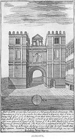
1600 print of Aldgate
Ward of Aldgate is located in Greater London
Ward of Aldgate
Ward of Aldgate
Location within Greater London
OS grid reference TQ334813
Sui generis
Administrative area Greater London
Region
Country England
Sovereign stateUnited Kingdom
Post town LONDON
Postcode district EC3
Dialling code 020
Police City of London
Fire London
Ambulance London
UK Parliament
London Assembly
List of places
UK
England
London
51°30′54″N 0°04′44″W / 51.51488°N 0.07890°W / 51.51488; -0.07890
Ward of Aldgate
1600 print of Aldgate
Ward of Aldgate is located in Greater London
Ward of Aldgate
Ward of Aldgate
Location within Greater London
OS grid reference TQ334813
Sui generis
Administrative area Greater London
Region
Country England
Sovereign stateUnited Kingdom
Post town LONDON
Postcode district EC3
Dialling code 020
Police City of London
Fire London
Ambulance London
UK Parliament
London Assembly
List of places
UK
England
London
51°30′54″N 0°04′44″W / 51.51488°N 0.07890°W / 51.51488; -0.07890

Metropolitan area ( Gosforth)

Side by side comparison
{{ Infobox UK place}}{{ Infobox UK place/sandbox}}
Gosforth
Gosforth is located in Tyne and Wear
Gosforth
Gosforth
Location within Tyne and Wear
Population23,620 (2001)
OS grid reference NZ250699
•  Edinburgh108 mi (174 km)
Metropolitan borough
Metropolitan county
Region
Country England
Sovereign stateUnited Kingdom
Post townNEWCASTLE UPON TYNE
Postcode district NE3
Dialling code0191
Police Northumbria
Fire Tyne and Wear
Ambulance North East
List of places
UK
England
Tyne and Wear
55°00′25″N 1°37′23″W / 55.007°N 1.623°W / 55.007; -1.623
Gosforth
Gosforth is located in Tyne and Wear
Gosforth
Gosforth
Location within Tyne and Wear
Population23,620 (2001)
OS grid reference NZ250699
•  Edinburgh108 mi (174 km)
Metropolitan borough
Metropolitan county
Region
Country England
Sovereign stateUnited Kingdom
Post townNEWCASTLE UPON TYNE
Postcode district NE3
Dialling code0191
Police Northumbria
Fire Tyne and Wear
Ambulance North East
List of places
UK
England
Tyne and Wear
55°00′25″N 1°37′23″W / 55.007°N 1.623°W / 55.007; -1.623

Two vertical images

Note that the live static_image* parameter values differ from the sandbox static_image* parameter values in this test case.

Side by side comparison
{{ Infobox UK place}}{{ Infobox UK place/sandbox}}
using static_image + no map
Image number 1 – width = 100
Image number 2 - width = 200
Area100 sq mi (260 km2)
PopulationCity of Belfast:
267,500 [1] 
Urban area:
483,418 [2]
Metropolitan area:
723,447 [3]
OS grid reference TQ765555
•  London32 miles (51 km) NW
District
Shire county
Country England
Sovereign stateUnited Kingdom
Post townAPPLEBY-IN-WESTMORLAND
Postcode district ME14-ME18
List of places
UK
England

Trivia update

Side by side comparison
{{ Infobox UK place}}{{ Infobox UK place/sandbox}}
A stone built house with red-tiled roof, overlooking a river. Behind a blue sky with white clouds.
River and Archbishop's Palace, Maidstone.
Infobox UK place/testcases is located in Kent
Infobox UK place/testcases
Location within Kent
Area100 sq mi (260 km2)
PopulationExpression error: "75,070 (2001)" must be numeric
OS grid reference TQ765555
•  London32 mi (51 km)  NW
•  Charing Cross50 mi (80 km)
District
Shire county
Region
Country England
Sovereign stateUnited Kingdom
Post townLower maidstone
Postcode district ME14–ME18
Dialling code01622
Police Kent
Fire Kent
Ambulance South East Coast
UK Parliament
List of places
UK
England
Kent
51°16′19″N 0°31′44″E / 51.272°N 0.529°E / 51.272; 0.529

All parameters

Side by side comparison
{{ Infobox UK place}}{{ Infobox UK place/sandbox}}
official_name Test link
[[File:static_image Test link|static_image_width Test link|alt=static_image_alt Test link]]
static_image_caption Test link
[[File:static_image_2 Test link|static_image_2_width Test link|alt=static_image_2_alt Test link]]
static_image_2_caption Test link
map_alt Test link
map_alt Test link
official_name Test link
Location within the United Kingdom
Area123,001 sq mi (318,570 km2 [4]
Population123,003  [5]
•  Densitypopulation_density Test link
Languagelanguage Test link
language1 Test link
language2 Test link
OS grid reference SK500600
Irish grid reference H300200
•  Belfast123,121 mi (198,144 km)123123  NE
•  Cardiff123,131 mi (198,160 km)123133  E
•  Douglas123,161 mi (198,208 km)123163  SW
•  Dublin123,141 mi (198,176 km)123143  SE
•  Edinburgh123,151 mi (198,192 km)123153  S
•  London123,111 mi (198,128 km)123113  N
•  Charing Cross123,171 mi (198,225 km)123173  W
Civil parish
Community
Principal area
Metropolitan borough
District
Unitary authority
Council area
District
Parishmanx_parish Test link
Preserved county
Greater London
Shire county
Metropolitan county
Ceremonial county
Lieutenancy area
County
Sheadingmanx_shedding Test link
Countrycountry Test link
Crown dependencycrown_dependency Test link
Sovereign stateUnited Kingdom
Post townpost_town Test link
Postcode district[[postcode_area Test link postcode area|postcode_district Test link]]
Post townpost_town1 Test link
Postcode district[[postcode_area1 Test link postcode area|postcode_district1 Test link]]
Post townpost_town2 Test link
Postcode district[[postcode_area2 Test link postcode area|postcode_district2 Test link]]
Dialling codedial_code Test link
dial_code1 Test link
dial_code2 Test link
Police 
Fire 
Ambulance 
UK Parliament
Scottish Parliament
Senedd Cymru – Welsh Parliament
House of Keysconstituency_manx_parliament Test link
NI Assembly
Websitewebsite Test link
List of places
United Kingdom
54°19′16″N 2°20′42″W / 54.321°N 2.345°W / 54.321; -2.345
official_name Test link
[[File:static_image Test link|static_image_width Test link|alt=static_image_alt Test link]]
static_image_caption Test link
[[File:static_image_2 Test link|static_image_2_width Test link|alt=static_image_2_alt Test link]]
static_image_2_caption Test link
map_alt Test link
map_alt Test link
official_name Test link
Location within the United Kingdom
Area123,001 sq mi (318,570 km2 [4]
Population123,003  [5]
•  Densitypopulation_density Test link
Languagelanguage Test link
language1 Test link
language2 Test link
OS grid reference SK500600
Irish grid reference H300200
•  Belfast123,121 mi (198,144 km)123123  NE
•  Cardiff123,131 mi (198,160 km)123133  E
•  Douglas123,161 mi (198,208 km)123163  SW
•  Dublin123,141 mi (198,176 km)123143  SE
•  Edinburgh123,151 mi (198,192 km)123153  S
•  London123,111 mi (198,128 km)123113  N
•  Charing Cross123,171 mi (198,225 km)123173  W
Civil parish
Community
Principal area
Metropolitan borough
District
Unitary authority
Council area
District
Parishmanx_parish Test link
Preserved county
Greater London
Shire county
Metropolitan county
Ceremonial county
Lieutenancy area
County
Sheadingmanx_shedding Test link
Countrycountry Test link
Crown dependencycrown_dependency Test link
Sovereign stateUnited Kingdom
Post townpost_town Test link
Postcode district[[postcode_area Test link postcode area|postcode_district Test link]]
Post townpost_town1 Test link
Postcode district[[postcode_area1 Test link postcode area|postcode_district1 Test link]]
Post townpost_town2 Test link
Postcode district[[postcode_area2 Test link postcode area|postcode_district2 Test link]]
Dialling codedial_code Test link
dial_code1 Test link
dial_code2 Test link
Police 
Fire 
Ambulance 
UK Parliament
Scottish Parliament
Senedd Cymru – Welsh Parliament
House of Keysconstituency_manx_parliament Test link
NI Assembly
Websitewebsite Test link
List of places
United Kingdom
54°19′16″N 2°20′42″W / 54.321°N 2.345°W / 54.321; -2.345

No parameters

Side by side comparison
{{ Infobox UK place}}{{ Infobox UK place/sandbox}}
Infobox UK place/testcases
Police 
Fire 
Ambulance 
List of places
United Kingdom
Infobox UK place/testcases
Police 
Fire 
Ambulance 
List of places
United Kingdom

Long post-town names

Side by side comparison
{{ Infobox UK place}}{{ Infobox UK place/sandbox}}
Post town 19+ chars
Ceremonial county
  • dummy to pad col 1
Post town APPLEBY-IN-WESTMORLAND
BROUGHTON-IN-FURNESS
KINGSTON UPON THAMES
LETCHWORTH GARDEN CITY
NEWBIGGIN-BY-THE-SEA
NEWCASTLE UPON TYNE
ST. LEONARDS-ON-SEA
SALTBURN-BY-THE-SEA
STOURPORT-ON-SEVERN
STRATFORD-UPON-AVON
List of places
United Kingdom

Llanfairpwllgwyngyll

Side by side comparison
{{ Infobox UK place}}{{ Infobox UK place/sandbox}}
Llanfairpwllgwyngyll
Preserved county
  • dummy to pad col 1
Post town LLANFAIRP​W​L​L​G​W​Y​N​G​Y​L​L (with ZWSP)
List of places
United Kingdom
Llanfairpwllgwyngyll
Preserved county
  • dummy to pad col 1
Post town LLANFAIRP​W​L​L​G​W​Y​N​G​Y​L​L (with ZWSP)
List of places
United Kingdom

Scotland location map

Aberdeen

Side by side comparison
{{ Infobox UK place}}{{ Infobox UK place/sandbox}}
Aberdeen
Aberdeen is located in Scotland
Aberdeen
Aberdeen
Location within Scotland
Population220,420 (2011 est.)
•  Density1,187/km2 (3,070/sq mi)
LanguageEnglish
Scots ( Doric)
OS grid reference NJ925065
•  Edinburgh94 mi (151 km)
•  London403 mi (649 km)
Country Scotland
Sovereign stateUnited Kingdom
Post townABERDEEN
Postcode district AB10-AB13 (part), AB15, AB16, AB21-AB25
Dialling code01224
Police Scotland
Fire Scottish
Ambulance Scottish
Website aberdeencity.gov.uk
List of places
UK
Scotland
57°09′09″N 2°06′36″W / 57.1526°N 2.1100°W / 57.1526; -2.1100
Aberdeen
Aberdeen is located in Scotland
Aberdeen
Aberdeen
Location within Scotland
Population220,420 (2011 est.)
•  Density1,187/km2 (3,070/sq mi)
LanguageEnglish
Scots ( Doric)
OS grid reference NJ925065
•  Edinburgh94 mi (151 km)
•  London403 mi (649 km)
Country Scotland
Sovereign stateUnited Kingdom
Post townAberdeen
Postcode district AB10-AB13 (part), AB15, AB16, AB21-AB25
Dialling code01224
Police Scotland
Fire Scottish
Ambulance Scottish
Website aberdeencity.gov.uk
List of places
UK
Scotland
57°09′09″N 2°06′36″W / 57.1526°N 2.1100°W / 57.1526; -2.1100

Dundee

Side by side comparison
{{ Infobox UK place}}{{ Infobox UK place/sandbox}}
Dundee
Dundee is located in Scotland
Dundee
Dundee
Location within Scotland
Area26 sq mi (67 km2)
Population152,320 (2008)
•  Density8,541.8/sq mi (3,298.0/km2)
LanguageEnglish, Scots
OS grid reference NO4030 twa ingin pehs
•  Edinburgh36.3 mi (58.4 km) SSW
•  London362.0 mi (582.6 km) SSE
Council area
  • Dundee
Lieutenancy area
  • Dundee
Country Scotland
Sovereign stateUnited Kingdom
Post townDUNDEE
Postcode district DD1–DD5
Dialling code01382
Police Scotland
Fire Scottish
Ambulance Scottish
UK Parliament
Website www.dundeecity.gov.uk
List of places
UK
Scotland
56°27′50″N 2°58′12″W / 56.464°N 2.970°W / 56.464; -2.970
Dundee
Dundee is located in Scotland
Dundee
Dundee
Location within Scotland
Area26 sq mi (67 km2)
Population152,320 (2008)
•  Density8,541.8/sq mi (3,298.0/km2)
LanguageEnglish, Scots
OS grid reference NO4030 twa ingin pehs
•  Edinburgh36.3 mi (58.4 km) SSW
•  London362.0 mi (582.6 km) SSE
Council area
  • Dundee
Lieutenancy area
  • Dundee
Country Scotland
Sovereign stateUnited Kingdom
Post townDundee
Postcode district DD1–DD5
Dialling code01382
Police Scotland
Fire Scottish
Ambulance Scottish
UK Parliament
Website www.dundeecity.gov.uk
List of places
UK
Scotland
56°27′50″N 2°58′12″W / 56.464°N 2.970°W / 56.464; -2.970

Cove Bay

Side by side comparison
{{ Infobox UK place}}{{ Infobox UK place/sandbox}}
Cove Bay
Cove Bay is located in Scotland
Cove Bay
Cove Bay
Location within Scotland
Population7,157  [1]
OS grid reference NJ946015
Community council
  • Cove and Altens
Council area
Lieutenancy area
Country Scotland
Sovereign stateUnited Kingdom
Post townABERDEEN
Postcode district AB12 3xx
Dialling code01224
Police Scotland
Fire Scottish
Ambulance Scottish
UK Parliament
Scottish Parliament
List of places
UK
Scotland
57°06′18″N 2°05′20″W / 57.105°N 2.089°W / 57.105; -2.089
Cove Bay
Cove Bay is located in Scotland
Cove Bay
Cove Bay
Location within Scotland
Population7,157  [2]
OS grid reference NJ946015
Community council
  • Cove and Altens
Council area
Lieutenancy area
Country Scotland
Sovereign stateUnited Kingdom
Post townAberdeen
Postcode district AB12 3xx
Dialling code01224
Police Scotland
Fire Scottish
Ambulance Scottish
UK Parliament
Scottish Parliament
List of places
UK
Scotland
57°06′18″N 2°05′20″W / 57.105°N 2.089°W / 57.105; -2.089

See also

Custom location map

New parameters: |pushpin_map=

Side by side comparison
{{ Infobox UK place}}{{ Infobox UK place/sandbox}}
Jericho
Jericho and the tower of St Barnabas Church seen from the Oxford Canal
Jericho is located in Oxford
Jericho
Jericho
Jericho is located in Oxfordshire
Jericho
Jericho
Location within Oxfordshire
OS grid reference SP504069
Civil parish
  • unparished
District
Shire county
Region
Country England
Sovereign stateUnited Kingdom
Post town Oxford
Postcode district OX2
Dialling code01865
Police Thames Valley
Fire Oxfordshire
Ambulance South Central
UK Parliament
Website Oxford City Council
List of places
UK
England
Oxfordshire
51°45′32″N 1°16′05″W / 51.759°N 1.268°W / 51.759; -1.268
Jericho
Jericho and the tower of St Barnabas Church seen from the Oxford Canal
Jericho is located in Oxford
Jericho
Jericho
Jericho is located in Oxfordshire
Jericho
Jericho
Location within Oxfordshire
OS grid reference SP504069
Civil parish
  • unparished
District
Shire county
Region
Country England
Sovereign stateUnited Kingdom
Post town Oxford
Postcode district OX2
Dialling code01865
Police Thames Valley
Fire Oxfordshire
Ambulance South Central
UK Parliament
Website Oxford City Council
List of places
UK
England
Oxfordshire
51°45′32″N 1°16′05″W / 51.759°N 1.268°W / 51.759; -1.268

Mapframe map with caption in static image 2

Side by side comparison
{{ Infobox UK place}}{{ Infobox UK place/sandbox}}
Box 1
Civil parish
Houses
Caption 1
List of places
United Kingdom
Box 1
Civil parish
Houses
Caption 1
List of places
United Kingdom

Mapframe map in module parameter

Side by side comparison
{{ Infobox UK place}}{{ Infobox UK place/sandbox}}
Box 1
Civil parish
Houses
List of places
United Kingdom
Box 1
Civil parish
Houses
List of places
United Kingdom

References

  1. ^ "Demography". NISRA. Retrieved 2009-05-30.
  2. ^ The UK’s major urban areas Office for National Statistics (Belfast Urban Area defined in footnote 6, page 16 of the pdf)
  3. ^ [Boal, F; Royle, S. (2006). Enduring City. Blackstaff Press Ltd] ("Going one step further, and viewing Belfast at the end of the twentieth century, we can consider places such as Carrickfergus, Antrim, Comber, Newtownards and Bangor as falling within the broadly defined 'Metropolitan Belfast' ")
  4. ^ area_footnotes Test link
  5. ^ population_ref Test link
Videos

Youtube | Vimeo | Bing

Websites

Google | Yahoo | Bing

Encyclopedia

Google | Yahoo | Bing

Facebook