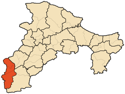
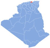
Photos • Location
This article needs additional citations for
verification. (August 2021) |
Tazmalt District | |
|---|---|
 | |
| Country | |
| Province | Béjaïa Province |
| Area | |
| • Total | 75 sq mi (193 km2) |
| Time zone | UTC+1 ( CET) |
Tazmalt District is a district of Béjaïa Province, Algeria.
Municipalities
The district is further divided into 3 municipalities: [1][ failed verification]
References
- ^ "Dairas et Communes" (in French). Site Officiel de la Wilaya de Béchar. Archived from the original on 16 February 2013. Retrieved 19 February 2013.
36°23′24″N 4°24′00″E / 36.39000°N 4.40000°E
This article needs additional citations for
verification. (August 2021) |
Tazmalt District | |
|---|---|
 | |
| Country | |
| Province | Béjaïa Province |
| Area | |
| • Total | 75 sq mi (193 km2) |
| Time zone | UTC+1 ( CET) |
Tazmalt District is a district of Béjaïa Province, Algeria.
Municipalities
The district is further divided into 3 municipalities: [1][ failed verification]
References
- ^ "Dairas et Communes" (in French). Site Officiel de la Wilaya de Béchar. Archived from the original on 16 February 2013. Retrieved 19 February 2013.
36°23′24″N 4°24′00″E / 36.39000°N 4.40000°E
