This article contains translated text and the factual accuracy of the translation should be checked by someone fluent in Georgian and English. |
Tao-Klarjeti | |
|---|---|
|
Map of modern Tao-Klarjeti, region Georgia lost in 1921 | |
| Area | Caucasus |
| Region | Western Asia |

Tao-Klarjeti ( Georgian: ტაო-კლარჯეთი, romanized: t'ao-k'larjeti) is a Georgian historical and cultural region in north-eastern Turkey. [1] The region is based around two river basins - Chorokhi and Kura (Mtkvari), and also partially includes the upper source of the Aras river. In modern usage it most often denotes the territory that was administered or claimed by Georgian Democratic Republic but is nowadays part of Turkey due to the Soviet-Turkish deal in 1921.
The term "Tao-Klarjeti" is based on the names of two most important provinces of the region — Tao and Klarjeti. [2] The term is equivalent to “ Zemo Kartli” (i.e., Upper Kartli or Upper Iberia) and is also a synonym for historical Meskheti. [3]
Cultural and historical heritage
.svg)
Many important Georgian cultural monuments from the middle ages are located on the territory of Tao-Klarjeti and many of them are preserved as ruins. Several monuments of medieval Georgian architecture – abandoned or converted churches, monasteries, bridges and castles – are scattered across the area.
Best known are the monasteries of Khandzta, Khakhuli, Ancha, the churches of Oshki, Ishkhani, Bana, Parkhali, Doliskana, Otkhta Eklesia, Opiza, Parekhi and Tbeti.
Gallery
-
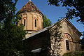
 Oshki Cathedral
 -
 Khakhuli Church
 -
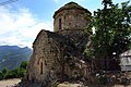 Dolisqana Church
 -
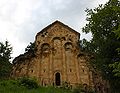
 Bana Cathedral
 -
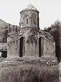
 Tbeti Cathedral
 -
 Parkhali Church
 -
 Otkhta Eklesia
 -
 Ekeki church
 -
 Ghulivati Castle
 -
 Kajeti Castle
 -
 Artanuji Castle
 -
 Tortomi Castle


.jpg)
_Castle,_Atina-Pazar,_Lazeti-Rize.jpg)


References
- ^ Harper, Katie Nadworny & Emma. "Turkey's forgotten Georgian kingdom". www.bbc.com. Retrieved 2022-07-09.
- ^ Mikaberidze, Alexander (February 6, 2015). Historical Dictionary of Georgia. Rowman & Littlefield. p. 625. ISBN 978-1442241466.
- ^ Suny, Ronald Grigor (1994). The Making of the Georgian Nation. Indiana University Press. p. 3. ISBN 0253209153.
- (in Georgian) "Tao-Klarjeti". (2006) Valeri Silogava and Kakha Shengelia. Caucasian University Press, Tbilisi. ISBN 99940-861-7-0
Historical regions of
Georgia | ||
|---|---|---|
| Abkhazia |  | |
| Adjara | ||
| Guria | ||
| Imereti | ||
| Kakheti | ||
| Kvemo Kartli | ||
| Mtskheta-Mtianeti | ||
| Racha-Lechkhumi and Kvemo Svaneti | ||
| Samegrelo-Zemo Svaneti | ||
| Shida Kartli | ||
| Tao-Klarjeti | ||
| International | |
|---|---|
| National | |
This article contains translated text and the factual accuracy of the translation should be checked by someone fluent in Georgian and English. |
Tao-Klarjeti | |
|---|---|
|
Map of modern Tao-Klarjeti, region Georgia lost in 1921 | |
| Area | Caucasus |
| Region | Western Asia |
Tao-Klarjeti ( Georgian: ტაო-კლარჯეთი, romanized: t'ao-k'larjeti) is a Georgian historical and cultural region in north-eastern Turkey. [1] The region is based around two river basins - Chorokhi and Kura (Mtkvari), and also partially includes the upper source of the Aras river. In modern usage it most often denotes the territory that was administered or claimed by Georgian Democratic Republic but is nowadays part of Turkey due to the Soviet-Turkish deal in 1921.
The term "Tao-Klarjeti" is based on the names of two most important provinces of the region — Tao and Klarjeti. [2] The term is equivalent to “ Zemo Kartli” (i.e., Upper Kartli or Upper Iberia) and is also a synonym for historical Meskheti. [3]
Cultural and historical heritage
Many important Georgian cultural monuments from the middle ages are located on the territory of Tao-Klarjeti and many of them are preserved as ruins. Several monuments of medieval Georgian architecture – abandoned or converted churches, monasteries, bridges and castles – are scattered across the area.
Best known are the monasteries of Khandzta, Khakhuli, Ancha, the churches of Oshki, Ishkhani, Bana, Parkhali, Doliskana, Otkhta Eklesia, Opiza, Parekhi and Tbeti.
Gallery
-
Oshki Cathedral
-
Khakhuli Church
-
Dolisqana Church
-
Bana Cathedral
-
Tbeti Cathedral
-
Parkhali Church
-
Otkhta Eklesia
-
Ekeki church
-
Ghulivati Castle
-
Kajeti Castle
-
Artanuji Castle
-
Tortomi Castle
References
- ^ Harper, Katie Nadworny & Emma. "Turkey's forgotten Georgian kingdom". www.bbc.com. Retrieved 2022-07-09.
- ^ Mikaberidze, Alexander (February 6, 2015). Historical Dictionary of Georgia. Rowman & Littlefield. p. 625. ISBN 978-1442241466.
- ^ Suny, Ronald Grigor (1994). The Making of the Georgian Nation. Indiana University Press. p. 3. ISBN 0253209153.
- (in Georgian) "Tao-Klarjeti". (2006) Valeri Silogava and Kakha Shengelia. Caucasian University Press, Tbilisi. ISBN 99940-861-7-0
Historical regions of
Georgia | ||
|---|---|---|
| Abkhazia | | |
| Adjara | ||
| Guria | ||
| Imereti | ||
| Kakheti | ||
| Kvemo Kartli | ||
| Mtskheta-Mtianeti | ||
| Racha-Lechkhumi and Kvemo Svaneti | ||
| Samegrelo-Zemo Svaneti | ||
| Shida Kartli | ||
| Tao-Klarjeti | ||
| International | |
|---|---|
| National | |