| This is the
talk page for discussing improvements to the
Frisland article. This is not a forum for general discussion of the article's subject. |
Article policies
|
| Find sources: Google ( books · news · scholar · free images · WP refs) · FENS · JSTOR · TWL |
|
| This article is rated Start-class on Wikipedia's
content assessment scale. It is of interest to the following WikiProjects: | |||||||
| ||||||||

![]() This article is or was the subject of a Wiki Education Foundation-supported course assignment. Further details are available
on the course page. Student editor(s):
Joney6241979.
This article is or was the subject of a Wiki Education Foundation-supported course assignment. Further details are available
on the course page. Student editor(s):
Joney6241979.
Above undated message substituted from Template:Dashboard.wikiedu.org assignment by PrimeBOT ( talk) 21:53, 16 January 2022 (UTC)
 —The preceding
unsigned comment was added by
TShilo12 (
talk •
contribs) 01:42, 7 May 2007 (UTC).
—The preceding
unsigned comment was added by
TShilo12 (
talk •
contribs) 01:42, 7 May 2007 (UTC).
Is there any connection between the Frisians mentioned in the Beowulf saga and this mythical Frisland? Arconada ( talk) 00:57, 29 March 2008 (UTC)
- Those Frisians are from
Frisia
Mikkel (
talk) 21:36, 16 March 2009 (UTC)
- Is there any explanation for the Frislandish imaginary place-names? Bondendea Harbour, Banar, Cape Spagia, Ocibar, Sorand, etc. —Preceding unsigned comment added by 212.142.175.22 ( talk) 09:52, 16 September 2009 (UTC)
- An old hoax, likeliest. Anthony Appleyard ( talk) 21:44, 25 December 2017 (UTC)
The article currently describes it as a "mythical island", which to me implies something from myth or legend (like Atlantis, or Lyoness). "Mythical island" is actually linked to Phantom island, which seems to describe "erroniously charted" islands (like Frisland), and is probably the best term to use for now as it is the article name, but looking at the talk page suggests that it is a non-standard term. How then should we describe Frisland? 62.172.108.23 ( talk) 11:26, 4 April 2012 (UTC)
- Tricky, a quick search shows both mythical and imaginary being used, eg [1], [2] and [3]. I understand what you are saying, but reliable sources use the word mythical... Dougweller ( talk) 12:21, 4 April 2012 (UTC)
It has been susgested that it appears as early as 1480, on A Catalan map mention here [4] (not sure if this is even an RS). So what is the provenance of this map? Slatersteven ( talk) 10:39, 30 December 2017 (UTC)
- Ok, that says "But there seems to have been some confusion in men’s minds between Iceland and Frisland as northern fishing centers and neighbois of like conditions. Thus the portolan atlas known as Egerton MS. 2803, contains two maps” (one shown in Fig. 8) naming Iceland “Fislanda,” and the notable Catalan map of about 1480” (Fig. 7), first copied by NordenskiOld, which shows Greenland as an elongated rectangular “Ilia Verde" and Brazil in the place later given to Estotiland, also depicts a large insular “Fixlanda,” which is surely Iceland, if any faith may be put in general outline and the arrangement of islets offshore. Prunes (i553; Fig- *2) substantially reproduces it, with the same name and apparently the same meaning. Zeno (Fig. 19) follows him closely in area and aspect but draws also an elongated Iceland to the northward, the latter island trending southwestward in imitation of Greenland and seeming to derive its geography therefrom. This version of Iceland was probably suggested by one of the Nicolaus Germanus maps above referred to." I need to do more research.
Doug Weller
talk 11:25, 30 December 2017 (UTC)
- Ah, between that and
this we probably have enough to fix this and not have our only source a fringe author.
Doug Weller
talk 11:31, 30 December 2017 (UTC)
- I think we have enough to push the date of earliest reference back to 1380.
Slatersteven (
talk) 13:36, 30 December 2017 (UTC)
- Also this. Doug Weller talk 19:36, 31 December 2017 (UTC)
- Some Landmarks in Icelandic Cartography down to the End of the Sixteenth Century Author(s): Haraldur Sigurdsson [5] "SEPTENTRIONALIVM PARTTVM NOVA TABVLA.
- I think we have enough to push the date of earliest reference back to 1380.
Slatersteven (
talk) 13:36, 30 December 2017 (UTC)
- Ah, between that and
this we probably have enough to fix this and not have our only source a fringe author.
Doug Weller
talk 11:31, 30 December 2017 (UTC)
21.6 x 30.5 cm. Engraving, copper. Girolamo Ruscclli (ca. 1504-1566).The charting of island* in the ocean was a significant contribution to mariners' maps. Tl»e importance of this map of the North Atlantic Ocean, engraved for the 1561 edition of Ptolemy's ATLAS and based on his projection, was to raise debate and controversy, over the inclusion of the non-existent islands of FR.1SLAND. ICAR1A and DEOGEO. This controversy would not subside till die twentieth century’." The Christopher Columbus Encyclopedia. Geographers: Biobibliographical Studies, Volume 10 Doug Weller talk 21:20, 2 January 2018 (UTC)
Reference by Slatersteven ( [6]) shows Fixland on page 64, lower left, as being from the 'Catalan Map of 1480'. It shows Fixland from a different map on page 66, upper left (in a discourse about Mayda, center left), as a copy of the Prunes map of 1553. Discussion of those maps, and the Zeno-type 'Frisland' maps, below in the section on fixing Fixland Youngnoah ( talk) 00:05, 5 January 2018 (UTC)Youngnoah
- See this. I hoped to have time today to work on his but real life and sockpuppetry got in the way. Doug Weller talk 18:46, 3 January 2018 (UTC)
As noted above ("Catalan map 1380"), there are two categories of maps for the article on Frisland. In one category they are called Fixland, and in the other Frisland. They appear to be of the same 'phantom' island. Certainly, no such island of that shape/size exists anywhere near the location for where they are shown (usually just below Iceland, and to the east of Greenland). It is well known that no such island exists there, hence the Frisland/Fixland island of the old maps is referred to as a phantom island.
However, the various maps are similar in shape/size, but nowhere near identical. They canot all be said to be copies of each other. (Several of the Zeno-style Frisland maps do appear to be copies of each other).
One of the major distinguishing features on all of the maps is a 'geographic anomaly' of a small cluster of small islands adjacent to the coast. This usually shows as likewise adjacent to a nearby extending small peninsula. They are usually shown in a circle, or oval, often with one or two islands in the center of the circle. For lack of a better term, I shall refer to that feature as the circle island cluster. It is that feature, showing on all of the maps in the article, that shows the connection of those various maps; plus other features (and the two names). I know of no other similar geologic feature for any actual islands on the planet (other than Newfoundland). Going clockwise from that 'circle island cluster', all of the maps also show a large peninsula, then rounding the peninsula a cluster of shoals/islands (not in a small circle), another peninsula, then a medium-sized island adjacent to the Frisland/Fixland island, then another peninsula, then returning back to the starting point (circle island group). If this were a real island, then any clock-wise circumnavigation would reveal those features, as shown on each of the Frisland/Fixland maps.
The article itself is not well-referenced as to it being a 'phantom island', and lacks verification for that conclusion.
To improve the article, it would be helpful to have a valid source proving that it is 'phantom', or a source showing that the similarities of the maps, but clearly not copies of each other by examination of the maps, is indicative of some actual location that gave rise to the various mappings. Youngnoah ( talk) 00:20, 5 January 2018 (UTC)Youngnoah.
- We need an RS to challenge the idea it is not a phantom Island. Slatersteven ( talk) 11:50, 5 January 2018 (UTC)
- There are several names, and we have the sources saying it never existed, just not in the article yet. Doug Weller talk 13:20, 5 January 2018 (UTC)
The great difficulty of early map makers was the problem of determining one's longitude. Latitude was relatively straight forward to determine, but longitude required the development of an accurate clock. This was such a great need that the British Goverment offered a prize to the person(s) who could develop an accurate marine clock. [1] This resulted in the first accurate marine clock (H-1) by John Harrison circa 1737. Thereafter, map-making could readily improve as the longitude of the new lands being discovered by western explorers could be accurately determined. Prior to that date, primitive methods of longitude determination resulted in serious errors of location of islands/lands, for which latitude could be relatively accurately determined. The early Frisland/Fixland maps were all from prior to the era of proper longitude determination. Youngnoah ( talk) 17:32, 8 January 2018 (UTC)Youngnoah
References
- Sorry, but that's irrelevant here. This isn't a forum, but a lot of new users do think that talk pages are for discussion of the subject of the article. I apologise I haven't found time yet. Doug Weller talk 19:40, 8 January 2018 (UTC)
Actually, it's not, as its suggestive that the problem of identification is one of longitude. This will be discussed more later. Youngnoah ( talk) 20:58, 8 January 2018 (UTC)Youngnoah
- Actuyally it is as they not only get its longitude wrong but its latitude as well, in fact it is (almost literally) all over then place. Slatersteven ( talk) 10:16, 9 January 2018 (UTC)
- My point is that we need sources discussing the alleged island - these may well exist. Our own thoughts aren't relevant and would belong in an Internet forum. Doug Weller talk 17:08, 9 January 2018 (UTC)
Slatersteven is correct that the latitude is way wrong too. But likewise, it is wrong even for Iceland ( https://upload.wikimedia.org/wikipedia/commons/5/56/Mercator_Septentrionalium_Terrarum_descriptio.jpg) as Iceland is actually to the south of the Arctic Circle ( /info/en/?search=Iceland#/media/File:Map_of_Iceland.svg). I'm not certain exactly how they were screwing that up too, but not question, they were. Longitude is easy to screw up, hence the reward for an accurate marine clock. Thereafter, mapping was far more reliable. James Cook used a Harrison clock on his famous journeys. It does not appear to me that those earlier charts simply invented a relatively large, fictitious island. What I would suggest is we set up a section in the article about the various ('fringe') theories that have been advanced. None of the theories are reliable, it would appear (except for the theory that it is actually an island with the latitude somewhat off, and the longitude wqay off, which you claim is not reliably sourced as having been advanced in the Portolan Journal). Youngnoah ( talk) 22:43, 9 January 2018 (UTC)Youngnoah
- Which you have not established is an RS. Slatersteven ( talk) 23:05, 9 January 2018 (UTC)
I've just confirmed it is peer reviewed. I'll provide that evidence shortly. Youngnoah ( talk) 00:56, 10 January 2018 (UTC)Youngnoah
- I don't think you can confirm that the Portolan is a properly peer reviewed journal. Sadly there are too many journals (hundreds now) claiming to be peer reviewed that actually aren't properly peer reviewed. If it was peer reviewed and was by an acknowledged expert, we might use it. But it's by someone with no qualifications and a fringe author at that, we'd only use it if a reliable source had commented on it. A fringe section would not be helpful, we need to write about this chronologically and thus Zeno will be dealt with appropriately. Doug Weller talk 10:10, 10 January 2018 (UTC)
The review is by a panel of their senior editors. Not someone with 'no qualifications', but rather persons with many years of experience reviewing articles for the journal. Peer review, in and of itself, does not determine the validity of the subject or proof it is true. Rather, it weeds out the purely flake articles, and gives a degree of credibility that the author is at least plausible. Youngnoah ( talk) 21:34, 10 January 2018 (UTC)Youngnoah
With respect to Slatersteven's assertion regarding latitude being wrong, that would imply that it was not being directly measured by instrument, but instead roughly measured by examining the relative position of Polaris (straight up, or roughly 30 degrees, etc.) compared to the horizon. I suspect that the Vikings did not make actual latitutde measurements by instrument, and instead sailed via 'dead reckoning' knowing roughly how far north/south they were, and how many days west of the last land fall they were.
With respect to the Viking encampment on Newfoundland, that is pure evidence they knew of the island. The articles indicate that encampment was for only a decade or two. What appears plausible is that after Leif discovered the western lands (Markland/Vinland), that they explored them and used them for lumber (and/or other stuff such as fish, fruit, etc.), in that the Greenland settlements (which lasted for centuries) had no lumber. They would not have established a boat-repair camp on Newfoundland ( /info/en/?search=L%27Anse_aux_Meadows), staffed it for a decade or longer, unless they had boats plying the waters on a regular basis. That implies strongly that Greenland had commerce with the Newfoundland area. While Thompsons extrapolates that to centuries of commerce (coinciding with the centuries of habitation of Greenland), I don't know that such is the case, without further research. Other than that, his article showing identities between Newfoundland and Frisland/Fixland appears well written, and it is understandable that it passed peer-review muster at the journal. Youngnoah ( talk) 21:59, 10 January 2018 (UTC)Youngnoah
Thomopson was not alone in suggesting more extensive traffic between Norse Greenland and the arctic over the centuries. Other respected researchers have suggested as such. "If Sutherland is correct, the lines of evidence she has uncovered may point to a previously unknown chapter in New World history in which Viking seafarers and Native American hunters were partners together in a transatlantic trade network. "I think things were a lot more complex in this part of the world than most people assumed," Sutherland said. James Tuck agreed. "It's pretty convincing that there was a much larger Norse presence in the Canadian Arctic than any of us thought."" https://news.nationalgeographic.com/news/2012/10/121019-viking-outpost-second-new-canada-science-sutherland/ Youngnoah ( talk) 00:12, 11 January 2018 (UTC)Youngnoah
The discovery of brown-bear and bison fur in Greenland settlements is further proof of commerce with North America ( https://books.google.com/books?id=FOkRDAAAQBAJ&pg=PA112#v=onepage&q&f=false). The orderly removal or furniture before abandonment of the dwellings is likewise suggestive that Greenland was abandoned en masse after several centuries of habitation. It is quite probable that some of them headed back to 'civilization'/Europe, no longer wanting to be in an ice-hole; while others might have headed to the nearby North American mainland. It would be interesting to do more archaeological exploration of the nearby North American shores to look for camps similar to those of Newfoundland. Youngnoah ( talk) 22:44, 10 January 2018 (UTC)Youngnoah
- A, the issue is not travel between Greenland and the arctic, no one has disputed that. The issue is the identification of Newfoundland with Freisland, bribing up unrelated evidence is Synthesis.
- B, Please read Peer review.
- C, Freisland moved around, both east and west and north and south. Sometimes to the west of Greenland (And I may be being generous here, as far as I can tell this ism a recent theory) mostly to the East (it is hard to imagine the Vikings no knowing at least if it was to the East or West of Greenland if they were travelling From there).08:51, 11 January 2018 (UTC)
- I'm not sure this discussion is worthwhile. Although we allow some original research on talk pages, this is getting into using it to prove a point, and one that we can't use in the article. And yes, that isn't peer review, nor do we know that the editors did anything but say "Yes, he's got lots of good sources and it sounds interesting". Doug Weller talk 09:05, 11 January 2018 (UTC)
We don't know that for any peer-reviewed article. Some peer-reviewed stuff is crap. From the Wikipedia page: "Peer review is the evaluation of work by one or more people of similar competence to the producers of the work (peers). It constitutes a form of self-regulation by qualified members of a profession within the relevant field. Peer review methods are employed to maintain standards of quality, improve performance, and provide credibility." Youngnoah ( talk) 17:22, 11 January 2018 (UTC)Youngnoah
- We know what most (if not all) journals that have a peer review process do, because they publish it. Yes some of it is crap, mistakes happen. Which is why the minimum we tend to require from an RS is a transparent peer review process. Rather then some vague and rather opaque process that seems to rest more on style then content. Slatersteven ( talk) 17:29, 11 January 2018 (UTC)
It appears the Portolan appears to rely on content, not style, as they are very proud of their 50 years of publication. From their 50th anniversary: "PORTOLAN 50th Anniversary … John Docktor, another past president and the Society’s webmaster, is a regular reviewer of new materials received on CD-ROM. In addition to these four particular members, many other members routinely step forward to review books received … The Portolan has attracted nationwide and worldwide attention. Several years ago we registered the journal for its own ISSN number – an accepted coding that every journal, magazine or newspaper has; with it researchers can quickly identify us. … (O)ther than the commercial Mercator’s World magazine, The Portolan is the only substantial nationwide US publication on the subject. Subscribers include renowned libraries at Harvard, Yale, the University of Texas at Arlington, and the New York Public Library. Several libraries have in the past two years ordered complete sets of back issues to complete their holdings – these include the Huntington Library, the Library of Virginia, the University of Michigan, Ohio State University, and the John Carter Brown Library at Brown University. Overseas institutions receiving The Portolan include The British Library, the National Archives of Canada, and the Bibliotheque Royale Albert I in Belgium. It is gratifying to be the editor of a journal that has received so much recognition and that is appreciated by the membership. - Thomas F. Sander, Editor" from: http://www.washmapsociety.org/000/0/9/8/22890/userfiles/file/Portolan_at_50_-_Spring_2001_-_PDF.pdf
While this does not detail their peer-review process, it shows they are very interested in quality to enhance their standing. This is a good example of a substantial peer-review process to maintain quality of publication. Youngnoah ( talk) 20:50, 11 January 2018 (UTC)Youngnoah
- Your right, it says zero about their peer review process, Also it says nothing on relying on content. Slatersteven ( talk) 11:34, 12 January 2018 (UTC)
Actually, it says that their peer-review is by the editors, and that it has resulted in wide recognition as being a reliable source. Youngnoah ( talk) 17:11, 12 January 2018 (UTC)Youngnoah
- Actually it does not say Peer review. Nor does it say what criteria the one editor users (before you say the obvious read what it says very carefully). Nor doers it say this has led to a reputation for being an RS, just that a few organisations subscribe to it. Nor is it an RS for the claim it is an RS.
Slatersteven (
talk) 17:15, 12 January 2018 (UTC)
- Editors plural? Who else besides Thomas Sander is an editor? And he's not an expert or an academic in a related field, he was a career army officer for 30 years. [7] Doug Weller talk 17:21, 12 January 2018 (UTC)
From above: "another past president and the Society’s webmaster, is a regular reviewer of new materials" . After some 17+ years as the editor, I'm sure that Thomas Sander knows a little about the subject. Youngnoah ( talk) 21:18, 12 January 2018 (UTC)Youngnoah
- So which other editors review article submissions? Slatersteven ( talk) 22:06, 12 January 2018 (UTC)
Don't know and don't care. It is at least 2, so I used the plural. A discussion on reliable sources was started here: /info/en/?search=Wikipedia:Reliable_sources/Noticeboard#Frisland_reliable_sources Youngnoah ( talk) 22:40, 12 January 2018 (UTC)Youngnoah
- Where does it mention at least 2? Slatersteven ( talk) 09:04, 13 January 2018 (UTC)
From above: "John Docktor, another past president and the Society’s webmaster, is a regular reviewer of new materials received on CD-ROM." Docktor, plus the current editor, are at least 2. Youngnoah ( talk) 20:41, 13 January 2018 (UTC)Youngnoah
- Not from the above "John Docktor, another past president and the Society’s webmaster, is also A regular reviewer", it says he is a regular reviewer not that anyone else it. Slatersteven ( talk) 21:21, 13 January 2018 (UTC)
It appears to this editor that all of the suggestions as to the origin of Frisland/Fixland on early maps (before the advent of accurate longitude determination) are in the category of being a fringe theory. One author suggests, without valid reference, that Frisland/Fixland might have been Iceland, even though it shows on maps with Iceland also. Another author suggests, without valid reference, that placement of Frisland/Fixland on the early maps is borne out of confusion with southern Greenland. Another author suggests, without valid reference, that placement is borne out of confusion with the Faroe islands, even though those also show on those early maps along with Frisland/FIxland. It is implied that Frisland/Fixland was purely imaginary, not borne from any actual sightings/measurements, and then replicated repeatedly as a phantom island, again without valid reference, even though the maps show significant change over time as if improved sightings were being made. One theory, that was published in the Portolan Journal, which other editors (DougWeller, Slatersteven) consider to be a fringe author, suggests that the confusion about Frisland/Fixland is primarily as to longitude, and that the island is not a phantom island but is actually the island of Newfoundland, longitudinally misplaced. Youngnoah ( talk) 18:32, 8 January 2018 (UTC)Youngnoah.
- The article you mention takes one if his Frisland maps for says it is Iceland. Also see above.
Slatersteven (
talk) 10:18, 9 January 2018 (UTC)
- The idea that Frisland was supposed to represent Newfoundland is so mixed up with fringe pseudohistorical bullshit, that I am prone to dismiss it... however, so are all the other postulated theories as to what it was supposed to represent. The simple reality is that we have no idea what Frisland was supposed to represent... or even if it was supposed to represent ANYTHING real. It may have been made up out of whole cloth... it may have been based on hearing sailors’ tails of an actual land sighting (but if so we don’t know which land)... it may have been a combination of the two. EVERY theory out there is mere speculation. We simply don’t know.
- However, we can determine which theories to mention in our article by examining WHY the theory is proposed... the context in which each theory is mentioned in sources. Those that are primarily used in the context of supporting fringe pseudo-historical bullshit should be given very little weight. The “it’s Newfoundland” claim is primarily made by proponents of the “Templars came to America” theory... a very fringe idea. This is why I hesitate to mention it. User:Blueboar|Blueboar]] ( talk) 00:02, 13 January 2018 (UTC)
I believe 'why' it is explained is not necessarily relevant. I agree, fringe theories such as 'Templars came to America' simply muddy the water. The article referenced that was written by Gunnar Thompson starts with an exposition of north-sea traffic in lumber/dried-fish. It is fairly well documented, however, that at least some of what he writes about is correct, in that the people of Greenland, who lived there for centuries, had trade with north america, including the ship-repair outpost on Newfoundland Island. It makes sense that the Greenland norse of those centuries obtained lumber and other goods in that trade. Whether they shipped Markland timber to Europe in addition to Greenland, as Gunnar Thompson says, I haven't researched well enough to say. It is at least plausible. Most of the research (other than Thompsons) shows they shipped Walrus ivory as their valuable goods, and when African ivory became available cheaper, they lost that market, and soon thereafter they left Greenland entirely.
Thompson then goes into comparing the various old maps of Frisland/Fixland with the actual map of Newfoundland. It is a very good match. In particular, Figures 5 and 6 of his article shows this strong match: http://marcopoloinseattle.com/wp/wp-content/uploads/2016/12/Portolan-Article-Newfoundland-Nov-2016-1.pdf I am suggesting it is a RS for the mapping comparisons. Youngnoah ( talk) 20:56, 13 January 2018 (UTC)Youngnoah
- The problem with Thompson is that he has a poor reputation. His theories regarding pre-columbian voyages to north America are not accepted by mainstream historians. This poor reputation can not be ignored. It impacts whether we can accept him as a reliable source. It does not matter whether you or I think his ideas "make sense". What matters is his reputation with other historians... and that is not good. You mention somewhere (I forget whether it was here or at RSN) that Thompson cites other sources... great... let's look at what those other sources say, and perhaps we can use them as well. Blueboar ( talk) 12:31, 14 January 2018 (UTC)
- I have't seen anything saying he has a 'poor reputation'. I've seen one book review that indicated the book was not worth acquiring. I agree he writes in areas that are not well-researched by 'mainstream' researchers. For example, he writes about Marco Polo visiting N. America and supports it with a map showing Kamchatka and Alaska purportedly drawn by Polo's daughters. I've not researched it enough to be able to verify the provenance of the map. But nevertheless, this is not about his other writings. He submitted the article in question (
http://marcopoloinseattle.com/wp/wp-content/uploads/2016/12/Portolan-Article-Newfoundland-Nov-2016-1.pdf) to a Map Society for peer review. I've also independently verified the provenance of the maps he included to support his claims. Apparently, he himself sought mainstream review by submitting to the Portolan Journal. On the other hand, I've not seen any form of review of the other theories as to the origin of
Frisland, in the article itself, though it posits various weird theories.
Youngnoah (
talk) 16:47, 15 January 2018 (UTC)Youngnoah
- Most fringe authors are largely ignored by academics. Fringe writers in this area love him. He worked with
Gavin Menzies and
Frank Joseph thinks he's great. On the other hand, the few mainstream authors who have commented are negative. This review
[8] in American Antiquity of NuSun:Asian-American Voyages 500 B.C about a Chinese merchant he claims traveled between south China and Mesoamerica sometime between 500 B.C. and 100 B.C. says "More than 150 heavily zip-a-toned drawings convincingly show that lots of Pacific folks made similar kinds of circles and curlicues. They even rendered people in unusual outfits with strange eyes! If you are unfettered by issues of chronology and distance these can be arranged in nifty charts. Unfortunately, others have done it all better—and they supply all of their references! This volume might have some appeal to the “Dungeons and Dragons” crowd, but it does not deserve to be on a scholarly bookshelf." I recall Thompson and Menzies years ago on the MapHist mailing list trying to convince the experts there about a map but failing completely. Kirsten Seaver reviewed his Marco Polo's Daughters in Imago Mundi
[9] concluding that he creates "a parallel fictive universe where a reader must travel with circumspection and scholarly disagreement is meaningless." Jason Colavito comments on Thompson's erros on the Albertin de Virga map
here as did Kirsten Seaver both in her review and another article.
[10]
Doug Weller
talk 19:05, 15 January 2018 (UTC)
- Yes,that is the book I referenced that got a bad review. I recently became aware of his others areas of research that are 'on the fringe' such as association with Menzies. The cite you give regarding the de Virga map does seem to show a possibility of it being either North America or Greenland. It still is not clear. That is not the case with the Newfoundland/Fixland maps. Apparently he finally found something where the maps make sense, and he was able to get it published in the peer-reviewed map society's Portolan Journal. I don't believe they've published any of his other stuff. One could say that after numerous strikeouts, he finally hit a home run. It is the maps themselves that give it away, not what he says. Youngnoah ( talk) 22:01, 15 January 2018 (UTC)Youngnoah
- Most fringe authors are largely ignored by academics. Fringe writers in this area love him. He worked with
Gavin Menzies and
Frank Joseph thinks he's great. On the other hand, the few mainstream authors who have commented are negative. This review
[8] in American Antiquity of NuSun:Asian-American Voyages 500 B.C about a Chinese merchant he claims traveled between south China and Mesoamerica sometime between 500 B.C. and 100 B.C. says "More than 150 heavily zip-a-toned drawings convincingly show that lots of Pacific folks made similar kinds of circles and curlicues. They even rendered people in unusual outfits with strange eyes! If you are unfettered by issues of chronology and distance these can be arranged in nifty charts. Unfortunately, others have done it all better—and they supply all of their references! This volume might have some appeal to the “Dungeons and Dragons” crowd, but it does not deserve to be on a scholarly bookshelf." I recall Thompson and Menzies years ago on the MapHist mailing list trying to convince the experts there about a map but failing completely. Kirsten Seaver reviewed his Marco Polo's Daughters in Imago Mundi
[9] concluding that he creates "a parallel fictive universe where a reader must travel with circumspection and scholarly disagreement is meaningless." Jason Colavito comments on Thompson's erros on the Albertin de Virga map
here as did Kirsten Seaver both in her review and another article.
[10]
Doug Weller
talk 19:05, 15 January 2018 (UTC)
- I have't seen anything saying he has a 'poor reputation'. I've seen one book review that indicated the book was not worth acquiring. I agree he writes in areas that are not well-researched by 'mainstream' researchers. For example, he writes about Marco Polo visiting N. America and supports it with a map showing Kamchatka and Alaska purportedly drawn by Polo's daughters. I've not researched it enough to be able to verify the provenance of the map. But nevertheless, this is not about his other writings. He submitted the article in question (
http://marcopoloinseattle.com/wp/wp-content/uploads/2016/12/Portolan-Article-Newfoundland-Nov-2016-1.pdf) to a Map Society for peer review. I've also independently verified the provenance of the maps he included to support his claims. Apparently, he himself sought mainstream review by submitting to the Portolan Journal. On the other hand, I've not seen any form of review of the other theories as to the origin of
Frisland, in the article itself, though it posits various weird theories.
Youngnoah (
talk) 16:47, 15 January 2018 (UTC)Youngnoah
- Perhaps I missed it, but I don't see in the Wikipedia links you provided for Gavin Menzies and Frank Joseph where Gunnar Thompson is mentioned. Are you making this up? Thompsons mentions Menzies in his work on China, but I'd not heard of Joseph before. Perhaps you've read more of these fringe authors than I. I'd not read of Thompson before I read his 'home run' article, so I guess I missed all the strike-outs that might have persuaded me not to read his article carefully. Youngnoah ( talk) 23:22, 15 January 2018 (UTC)Youngnoah
- Why would you expect Thompson to be mentioned in those Wikipedia articles? If you'd actually researched it (Googled for both names) you'd find, for instance, that Menzies wrote a forward for Thompson's Secret Voyages to the New World".
[11]. As for making things up, I've never seen any point to that, but your lack of
good faith in making the suggestion might mean that it's something your used to. And yes, I've been interested in pseudoarchaeology for a couple of decades and have been mentioned in Archaeology Magazine.
Doug Weller
talk 15:16, 16 January 2018 (UTC)
- I expected Thompson to be mentioned in those two web pages because you linked to their wikipedia articles. I'm really not interested in reading pseudoarchaeology or about the proponents thereof. And yes, I now expect you consider Thompson to be in that category. But with respect to his article on Frisland, I don't see that. He researched it well, cited extensively as to how he reached his conclusions, showed many maps and how they changed over time, and how they look very much like Newfoundland, and gave a strong plausibility argument that Newfoundland was well-documented back in the day when norse routinely sailed there and around the island, and hence descriptions of it would have been known in Europe. I do not consider that to be pseudoarchaeology. Not to make this a spittin' contest, but your insinuations seem to smack of a lack of good faith. Youngnoah ( talk) 00:19, 18 January 2018 (UTC)Youngnoah
- Why would you expect Thompson to be mentioned in those Wikipedia articles? If you'd actually researched it (Googled for both names) you'd find, for instance, that Menzies wrote a forward for Thompson's Secret Voyages to the New World".
[11]. As for making things up, I've never seen any point to that, but your lack of
good faith in making the suggestion might mean that it's something your used to. And yes, I've been interested in pseudoarchaeology for a couple of decades and have been mentioned in Archaeology Magazine.
Doug Weller
talk 15:16, 16 January 2018 (UTC)
| This is the
talk page for discussing improvements to the
Frisland article. This is not a forum for general discussion of the article's subject. |
Article policies
|
| Find sources: Google ( books · news · scholar · free images · WP refs) · FENS · JSTOR · TWL |
|
| This article is rated Start-class on Wikipedia's
content assessment scale. It is of interest to the following WikiProjects: | |||||||
| ||||||||
![]() This article is or was the subject of a Wiki Education Foundation-supported course assignment. Further details are available
on the course page. Student editor(s):
Joney6241979.
This article is or was the subject of a Wiki Education Foundation-supported course assignment. Further details are available
on the course page. Student editor(s):
Joney6241979.
Above undated message substituted from Template:Dashboard.wikiedu.org assignment by PrimeBOT ( talk) 21:53, 16 January 2022 (UTC)
—The preceding
unsigned comment was added by
TShilo12 (
talk •
contribs) 01:42, 7 May 2007 (UTC).
Is there any connection between the Frisians mentioned in the Beowulf saga and this mythical Frisland? Arconada ( talk) 00:57, 29 March 2008 (UTC)
- Those Frisians are from
Frisia
Mikkel (
talk) 21:36, 16 March 2009 (UTC)
- Is there any explanation for the Frislandish imaginary place-names? Bondendea Harbour, Banar, Cape Spagia, Ocibar, Sorand, etc. —Preceding unsigned comment added by 212.142.175.22 ( talk) 09:52, 16 September 2009 (UTC)
- An old hoax, likeliest. Anthony Appleyard ( talk) 21:44, 25 December 2017 (UTC)
The article currently describes it as a "mythical island", which to me implies something from myth or legend (like Atlantis, or Lyoness). "Mythical island" is actually linked to Phantom island, which seems to describe "erroniously charted" islands (like Frisland), and is probably the best term to use for now as it is the article name, but looking at the talk page suggests that it is a non-standard term. How then should we describe Frisland? 62.172.108.23 ( talk) 11:26, 4 April 2012 (UTC)
- Tricky, a quick search shows both mythical and imaginary being used, eg [1], [2] and [3]. I understand what you are saying, but reliable sources use the word mythical... Dougweller ( talk) 12:21, 4 April 2012 (UTC)
It has been susgested that it appears as early as 1480, on A Catalan map mention here [4] (not sure if this is even an RS). So what is the provenance of this map? Slatersteven ( talk) 10:39, 30 December 2017 (UTC)
- Ok, that says "But there seems to have been some confusion in men’s minds between Iceland and Frisland as northern fishing centers and neighbois of like conditions. Thus the portolan atlas known as Egerton MS. 2803, contains two maps” (one shown in Fig. 8) naming Iceland “Fislanda,” and the notable Catalan map of about 1480” (Fig. 7), first copied by NordenskiOld, which shows Greenland as an elongated rectangular “Ilia Verde" and Brazil in the place later given to Estotiland, also depicts a large insular “Fixlanda,” which is surely Iceland, if any faith may be put in general outline and the arrangement of islets offshore. Prunes (i553; Fig- *2) substantially reproduces it, with the same name and apparently the same meaning. Zeno (Fig. 19) follows him closely in area and aspect but draws also an elongated Iceland to the northward, the latter island trending southwestward in imitation of Greenland and seeming to derive its geography therefrom. This version of Iceland was probably suggested by one of the Nicolaus Germanus maps above referred to." I need to do more research.
Doug Weller
talk 11:25, 30 December 2017 (UTC)
- Ah, between that and
this we probably have enough to fix this and not have our only source a fringe author.
Doug Weller
talk 11:31, 30 December 2017 (UTC)
- I think we have enough to push the date of earliest reference back to 1380.
Slatersteven (
talk) 13:36, 30 December 2017 (UTC)
- Also this. Doug Weller talk 19:36, 31 December 2017 (UTC)
- Some Landmarks in Icelandic Cartography down to the End of the Sixteenth Century Author(s): Haraldur Sigurdsson [5] "SEPTENTRIONALIVM PARTTVM NOVA TABVLA.
- I think we have enough to push the date of earliest reference back to 1380.
Slatersteven (
talk) 13:36, 30 December 2017 (UTC)
- Ah, between that and
this we probably have enough to fix this and not have our only source a fringe author.
Doug Weller
talk 11:31, 30 December 2017 (UTC)
21.6 x 30.5 cm. Engraving, copper. Girolamo Ruscclli (ca. 1504-1566).The charting of island* in the ocean was a significant contribution to mariners' maps. Tl»e importance of this map of the North Atlantic Ocean, engraved for the 1561 edition of Ptolemy's ATLAS and based on his projection, was to raise debate and controversy, over the inclusion of the non-existent islands of FR.1SLAND. ICAR1A and DEOGEO. This controversy would not subside till die twentieth century’." The Christopher Columbus Encyclopedia. Geographers: Biobibliographical Studies, Volume 10 Doug Weller talk 21:20, 2 January 2018 (UTC)
Reference by Slatersteven ( [6]) shows Fixland on page 64, lower left, as being from the 'Catalan Map of 1480'. It shows Fixland from a different map on page 66, upper left (in a discourse about Mayda, center left), as a copy of the Prunes map of 1553. Discussion of those maps, and the Zeno-type 'Frisland' maps, below in the section on fixing Fixland Youngnoah ( talk) 00:05, 5 January 2018 (UTC)Youngnoah
- See this. I hoped to have time today to work on his but real life and sockpuppetry got in the way. Doug Weller talk 18:46, 3 January 2018 (UTC)
As noted above ("Catalan map 1380"), there are two categories of maps for the article on Frisland. In one category they are called Fixland, and in the other Frisland. They appear to be of the same 'phantom' island. Certainly, no such island of that shape/size exists anywhere near the location for where they are shown (usually just below Iceland, and to the east of Greenland). It is well known that no such island exists there, hence the Frisland/Fixland island of the old maps is referred to as a phantom island.
However, the various maps are similar in shape/size, but nowhere near identical. They canot all be said to be copies of each other. (Several of the Zeno-style Frisland maps do appear to be copies of each other).
One of the major distinguishing features on all of the maps is a 'geographic anomaly' of a small cluster of small islands adjacent to the coast. This usually shows as likewise adjacent to a nearby extending small peninsula. They are usually shown in a circle, or oval, often with one or two islands in the center of the circle. For lack of a better term, I shall refer to that feature as the circle island cluster. It is that feature, showing on all of the maps in the article, that shows the connection of those various maps; plus other features (and the two names). I know of no other similar geologic feature for any actual islands on the planet (other than Newfoundland). Going clockwise from that 'circle island cluster', all of the maps also show a large peninsula, then rounding the peninsula a cluster of shoals/islands (not in a small circle), another peninsula, then a medium-sized island adjacent to the Frisland/Fixland island, then another peninsula, then returning back to the starting point (circle island group). If this were a real island, then any clock-wise circumnavigation would reveal those features, as shown on each of the Frisland/Fixland maps.
The article itself is not well-referenced as to it being a 'phantom island', and lacks verification for that conclusion.
To improve the article, it would be helpful to have a valid source proving that it is 'phantom', or a source showing that the similarities of the maps, but clearly not copies of each other by examination of the maps, is indicative of some actual location that gave rise to the various mappings. Youngnoah ( talk) 00:20, 5 January 2018 (UTC)Youngnoah.
- We need an RS to challenge the idea it is not a phantom Island. Slatersteven ( talk) 11:50, 5 January 2018 (UTC)
- There are several names, and we have the sources saying it never existed, just not in the article yet. Doug Weller talk 13:20, 5 January 2018 (UTC)
The great difficulty of early map makers was the problem of determining one's longitude. Latitude was relatively straight forward to determine, but longitude required the development of an accurate clock. This was such a great need that the British Goverment offered a prize to the person(s) who could develop an accurate marine clock. [1] This resulted in the first accurate marine clock (H-1) by John Harrison circa 1737. Thereafter, map-making could readily improve as the longitude of the new lands being discovered by western explorers could be accurately determined. Prior to that date, primitive methods of longitude determination resulted in serious errors of location of islands/lands, for which latitude could be relatively accurately determined. The early Frisland/Fixland maps were all from prior to the era of proper longitude determination. Youngnoah ( talk) 17:32, 8 January 2018 (UTC)Youngnoah
References
- Sorry, but that's irrelevant here. This isn't a forum, but a lot of new users do think that talk pages are for discussion of the subject of the article. I apologise I haven't found time yet. Doug Weller talk 19:40, 8 January 2018 (UTC)
Actually, it's not, as its suggestive that the problem of identification is one of longitude. This will be discussed more later. Youngnoah ( talk) 20:58, 8 January 2018 (UTC)Youngnoah
- Actuyally it is as they not only get its longitude wrong but its latitude as well, in fact it is (almost literally) all over then place. Slatersteven ( talk) 10:16, 9 January 2018 (UTC)
- My point is that we need sources discussing the alleged island - these may well exist. Our own thoughts aren't relevant and would belong in an Internet forum. Doug Weller talk 17:08, 9 January 2018 (UTC)
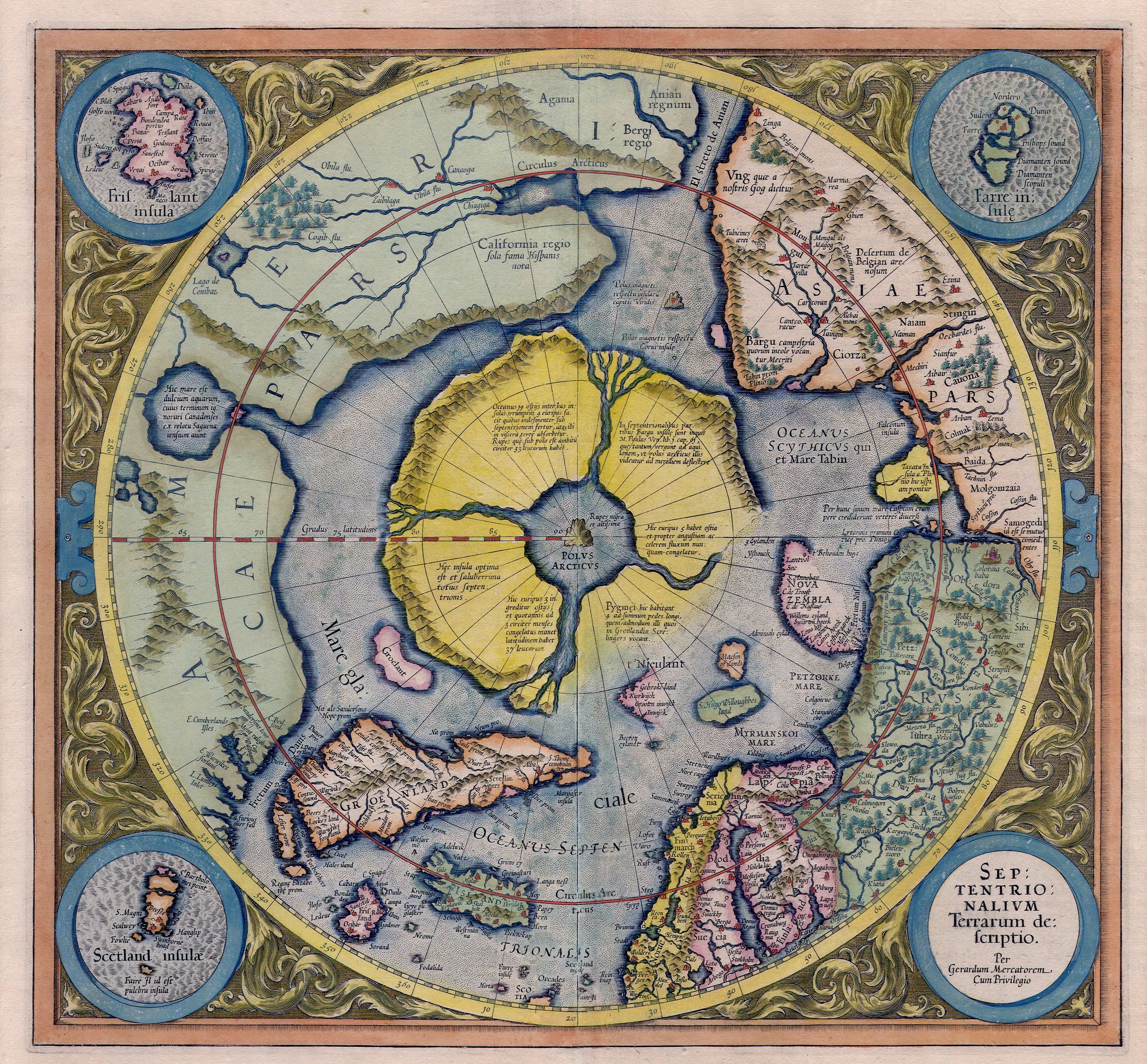
Slatersteven is correct that the latitude is way wrong too. But likewise, it is wrong even for Iceland ( https://upload.wikimedia.org/wikipedia/commons/5/56/Mercator_Septentrionalium_Terrarum_descriptio.jpg) as Iceland is actually to the south of the Arctic Circle ( /info/en/?search=Iceland#/media/File:Map_of_Iceland.svg). I'm not certain exactly how they were screwing that up too, but not question, they were. Longitude is easy to screw up, hence the reward for an accurate marine clock. Thereafter, mapping was far more reliable. James Cook used a Harrison clock on his famous journeys. It does not appear to me that those earlier charts simply invented a relatively large, fictitious island. What I would suggest is we set up a section in the article about the various ('fringe') theories that have been advanced. None of the theories are reliable, it would appear (except for the theory that it is actually an island with the latitude somewhat off, and the longitude wqay off, which you claim is not reliably sourced as having been advanced in the Portolan Journal). Youngnoah ( talk) 22:43, 9 January 2018 (UTC)Youngnoah
- Which you have not established is an RS. Slatersteven ( talk) 23:05, 9 January 2018 (UTC)
I've just confirmed it is peer reviewed. I'll provide that evidence shortly. Youngnoah ( talk) 00:56, 10 January 2018 (UTC)Youngnoah
- I don't think you can confirm that the Portolan is a properly peer reviewed journal. Sadly there are too many journals (hundreds now) claiming to be peer reviewed that actually aren't properly peer reviewed. If it was peer reviewed and was by an acknowledged expert, we might use it. But it's by someone with no qualifications and a fringe author at that, we'd only use it if a reliable source had commented on it. A fringe section would not be helpful, we need to write about this chronologically and thus Zeno will be dealt with appropriately. Doug Weller talk 10:10, 10 January 2018 (UTC)
The review is by a panel of their senior editors. Not someone with 'no qualifications', but rather persons with many years of experience reviewing articles for the journal. Peer review, in and of itself, does not determine the validity of the subject or proof it is true. Rather, it weeds out the purely flake articles, and gives a degree of credibility that the author is at least plausible. Youngnoah ( talk) 21:34, 10 January 2018 (UTC)Youngnoah
With respect to Slatersteven's assertion regarding latitude being wrong, that would imply that it was not being directly measured by instrument, but instead roughly measured by examining the relative position of Polaris (straight up, or roughly 30 degrees, etc.) compared to the horizon. I suspect that the Vikings did not make actual latitutde measurements by instrument, and instead sailed via 'dead reckoning' knowing roughly how far north/south they were, and how many days west of the last land fall they were.
With respect to the Viking encampment on Newfoundland, that is pure evidence they knew of the island. The articles indicate that encampment was for only a decade or two. What appears plausible is that after Leif discovered the western lands (Markland/Vinland), that they explored them and used them for lumber (and/or other stuff such as fish, fruit, etc.), in that the Greenland settlements (which lasted for centuries) had no lumber. They would not have established a boat-repair camp on Newfoundland ( /info/en/?search=L%27Anse_aux_Meadows), staffed it for a decade or longer, unless they had boats plying the waters on a regular basis. That implies strongly that Greenland had commerce with the Newfoundland area. While Thompsons extrapolates that to centuries of commerce (coinciding with the centuries of habitation of Greenland), I don't know that such is the case, without further research. Other than that, his article showing identities between Newfoundland and Frisland/Fixland appears well written, and it is understandable that it passed peer-review muster at the journal. Youngnoah ( talk) 21:59, 10 January 2018 (UTC)Youngnoah
Thomopson was not alone in suggesting more extensive traffic between Norse Greenland and the arctic over the centuries. Other respected researchers have suggested as such. "If Sutherland is correct, the lines of evidence she has uncovered may point to a previously unknown chapter in New World history in which Viking seafarers and Native American hunters were partners together in a transatlantic trade network. "I think things were a lot more complex in this part of the world than most people assumed," Sutherland said. James Tuck agreed. "It's pretty convincing that there was a much larger Norse presence in the Canadian Arctic than any of us thought."" https://news.nationalgeographic.com/news/2012/10/121019-viking-outpost-second-new-canada-science-sutherland/ Youngnoah ( talk) 00:12, 11 January 2018 (UTC)Youngnoah
The discovery of brown-bear and bison fur in Greenland settlements is further proof of commerce with North America ( https://books.google.com/books?id=FOkRDAAAQBAJ&pg=PA112#v=onepage&q&f=false). The orderly removal or furniture before abandonment of the dwellings is likewise suggestive that Greenland was abandoned en masse after several centuries of habitation. It is quite probable that some of them headed back to 'civilization'/Europe, no longer wanting to be in an ice-hole; while others might have headed to the nearby North American mainland. It would be interesting to do more archaeological exploration of the nearby North American shores to look for camps similar to those of Newfoundland. Youngnoah ( talk) 22:44, 10 January 2018 (UTC)Youngnoah
- A, the issue is not travel between Greenland and the arctic, no one has disputed that. The issue is the identification of Newfoundland with Freisland, bribing up unrelated evidence is Synthesis.
- B, Please read Peer review.
- C, Freisland moved around, both east and west and north and south. Sometimes to the west of Greenland (And I may be being generous here, as far as I can tell this ism a recent theory) mostly to the East (it is hard to imagine the Vikings no knowing at least if it was to the East or West of Greenland if they were travelling From there).08:51, 11 January 2018 (UTC)
- I'm not sure this discussion is worthwhile. Although we allow some original research on talk pages, this is getting into using it to prove a point, and one that we can't use in the article. And yes, that isn't peer review, nor do we know that the editors did anything but say "Yes, he's got lots of good sources and it sounds interesting". Doug Weller talk 09:05, 11 January 2018 (UTC)
We don't know that for any peer-reviewed article. Some peer-reviewed stuff is crap. From the Wikipedia page: "Peer review is the evaluation of work by one or more people of similar competence to the producers of the work (peers). It constitutes a form of self-regulation by qualified members of a profession within the relevant field. Peer review methods are employed to maintain standards of quality, improve performance, and provide credibility." Youngnoah ( talk) 17:22, 11 January 2018 (UTC)Youngnoah
- We know what most (if not all) journals that have a peer review process do, because they publish it. Yes some of it is crap, mistakes happen. Which is why the minimum we tend to require from an RS is a transparent peer review process. Rather then some vague and rather opaque process that seems to rest more on style then content. Slatersteven ( talk) 17:29, 11 January 2018 (UTC)
It appears the Portolan appears to rely on content, not style, as they are very proud of their 50 years of publication. From their 50th anniversary: "PORTOLAN 50th Anniversary … John Docktor, another past president and the Society’s webmaster, is a regular reviewer of new materials received on CD-ROM. In addition to these four particular members, many other members routinely step forward to review books received … The Portolan has attracted nationwide and worldwide attention. Several years ago we registered the journal for its own ISSN number – an accepted coding that every journal, magazine or newspaper has; with it researchers can quickly identify us. … (O)ther than the commercial Mercator’s World magazine, The Portolan is the only substantial nationwide US publication on the subject. Subscribers include renowned libraries at Harvard, Yale, the University of Texas at Arlington, and the New York Public Library. Several libraries have in the past two years ordered complete sets of back issues to complete their holdings – these include the Huntington Library, the Library of Virginia, the University of Michigan, Ohio State University, and the John Carter Brown Library at Brown University. Overseas institutions receiving The Portolan include The British Library, the National Archives of Canada, and the Bibliotheque Royale Albert I in Belgium. It is gratifying to be the editor of a journal that has received so much recognition and that is appreciated by the membership. - Thomas F. Sander, Editor" from: http://www.washmapsociety.org/000/0/9/8/22890/userfiles/file/Portolan_at_50_-_Spring_2001_-_PDF.pdf
While this does not detail their peer-review process, it shows they are very interested in quality to enhance their standing. This is a good example of a substantial peer-review process to maintain quality of publication. Youngnoah ( talk) 20:50, 11 January 2018 (UTC)Youngnoah
- Your right, it says zero about their peer review process, Also it says nothing on relying on content. Slatersteven ( talk) 11:34, 12 January 2018 (UTC)
Actually, it says that their peer-review is by the editors, and that it has resulted in wide recognition as being a reliable source. Youngnoah ( talk) 17:11, 12 January 2018 (UTC)Youngnoah
- Actually it does not say Peer review. Nor does it say what criteria the one editor users (before you say the obvious read what it says very carefully). Nor doers it say this has led to a reputation for being an RS, just that a few organisations subscribe to it. Nor is it an RS for the claim it is an RS.
Slatersteven (
talk) 17:15, 12 January 2018 (UTC)
- Editors plural? Who else besides Thomas Sander is an editor? And he's not an expert or an academic in a related field, he was a career army officer for 30 years. [7] Doug Weller talk 17:21, 12 January 2018 (UTC)
From above: "another past president and the Society’s webmaster, is a regular reviewer of new materials" . After some 17+ years as the editor, I'm sure that Thomas Sander knows a little about the subject. Youngnoah ( talk) 21:18, 12 January 2018 (UTC)Youngnoah
- So which other editors review article submissions? Slatersteven ( talk) 22:06, 12 January 2018 (UTC)
Don't know and don't care. It is at least 2, so I used the plural. A discussion on reliable sources was started here: /info/en/?search=Wikipedia:Reliable_sources/Noticeboard#Frisland_reliable_sources Youngnoah ( talk) 22:40, 12 January 2018 (UTC)Youngnoah
- Where does it mention at least 2? Slatersteven ( talk) 09:04, 13 January 2018 (UTC)
From above: "John Docktor, another past president and the Society’s webmaster, is a regular reviewer of new materials received on CD-ROM." Docktor, plus the current editor, are at least 2. Youngnoah ( talk) 20:41, 13 January 2018 (UTC)Youngnoah
- Not from the above "John Docktor, another past president and the Society’s webmaster, is also A regular reviewer", it says he is a regular reviewer not that anyone else it. Slatersteven ( talk) 21:21, 13 January 2018 (UTC)
It appears to this editor that all of the suggestions as to the origin of Frisland/Fixland on early maps (before the advent of accurate longitude determination) are in the category of being a fringe theory. One author suggests, without valid reference, that Frisland/Fixland might have been Iceland, even though it shows on maps with Iceland also. Another author suggests, without valid reference, that placement of Frisland/Fixland on the early maps is borne out of confusion with southern Greenland. Another author suggests, without valid reference, that placement is borne out of confusion with the Faroe islands, even though those also show on those early maps along with Frisland/FIxland. It is implied that Frisland/Fixland was purely imaginary, not borne from any actual sightings/measurements, and then replicated repeatedly as a phantom island, again without valid reference, even though the maps show significant change over time as if improved sightings were being made. One theory, that was published in the Portolan Journal, which other editors (DougWeller, Slatersteven) consider to be a fringe author, suggests that the confusion about Frisland/Fixland is primarily as to longitude, and that the island is not a phantom island but is actually the island of Newfoundland, longitudinally misplaced. Youngnoah ( talk) 18:32, 8 January 2018 (UTC)Youngnoah.
- The article you mention takes one if his Frisland maps for says it is Iceland. Also see above.
Slatersteven (
talk) 10:18, 9 January 2018 (UTC)
- The idea that Frisland was supposed to represent Newfoundland is so mixed up with fringe pseudohistorical bullshit, that I am prone to dismiss it... however, so are all the other postulated theories as to what it was supposed to represent. The simple reality is that we have no idea what Frisland was supposed to represent... or even if it was supposed to represent ANYTHING real. It may have been made up out of whole cloth... it may have been based on hearing sailors’ tails of an actual land sighting (but if so we don’t know which land)... it may have been a combination of the two. EVERY theory out there is mere speculation. We simply don’t know.
- However, we can determine which theories to mention in our article by examining WHY the theory is proposed... the context in which each theory is mentioned in sources. Those that are primarily used in the context of supporting fringe pseudo-historical bullshit should be given very little weight. The “it’s Newfoundland” claim is primarily made by proponents of the “Templars came to America” theory... a very fringe idea. This is why I hesitate to mention it. User:Blueboar|Blueboar]] ( talk) 00:02, 13 January 2018 (UTC)
I believe 'why' it is explained is not necessarily relevant. I agree, fringe theories such as 'Templars came to America' simply muddy the water. The article referenced that was written by Gunnar Thompson starts with an exposition of north-sea traffic in lumber/dried-fish. It is fairly well documented, however, that at least some of what he writes about is correct, in that the people of Greenland, who lived there for centuries, had trade with north america, including the ship-repair outpost on Newfoundland Island. It makes sense that the Greenland norse of those centuries obtained lumber and other goods in that trade. Whether they shipped Markland timber to Europe in addition to Greenland, as Gunnar Thompson says, I haven't researched well enough to say. It is at least plausible. Most of the research (other than Thompsons) shows they shipped Walrus ivory as their valuable goods, and when African ivory became available cheaper, they lost that market, and soon thereafter they left Greenland entirely.
Thompson then goes into comparing the various old maps of Frisland/Fixland with the actual map of Newfoundland. It is a very good match. In particular, Figures 5 and 6 of his article shows this strong match: http://marcopoloinseattle.com/wp/wp-content/uploads/2016/12/Portolan-Article-Newfoundland-Nov-2016-1.pdf I am suggesting it is a RS for the mapping comparisons. Youngnoah ( talk) 20:56, 13 January 2018 (UTC)Youngnoah
- The problem with Thompson is that he has a poor reputation. His theories regarding pre-columbian voyages to north America are not accepted by mainstream historians. This poor reputation can not be ignored. It impacts whether we can accept him as a reliable source. It does not matter whether you or I think his ideas "make sense". What matters is his reputation with other historians... and that is not good. You mention somewhere (I forget whether it was here or at RSN) that Thompson cites other sources... great... let's look at what those other sources say, and perhaps we can use them as well. Blueboar ( talk) 12:31, 14 January 2018 (UTC)
- I have't seen anything saying he has a 'poor reputation'. I've seen one book review that indicated the book was not worth acquiring. I agree he writes in areas that are not well-researched by 'mainstream' researchers. For example, he writes about Marco Polo visiting N. America and supports it with a map showing Kamchatka and Alaska purportedly drawn by Polo's daughters. I've not researched it enough to be able to verify the provenance of the map. But nevertheless, this is not about his other writings. He submitted the article in question (
http://marcopoloinseattle.com/wp/wp-content/uploads/2016/12/Portolan-Article-Newfoundland-Nov-2016-1.pdf) to a Map Society for peer review. I've also independently verified the provenance of the maps he included to support his claims. Apparently, he himself sought mainstream review by submitting to the Portolan Journal. On the other hand, I've not seen any form of review of the other theories as to the origin of
Frisland, in the article itself, though it posits various weird theories.
Youngnoah (
talk) 16:47, 15 January 2018 (UTC)Youngnoah
- Most fringe authors are largely ignored by academics. Fringe writers in this area love him. He worked with
Gavin Menzies and
Frank Joseph thinks he's great. On the other hand, the few mainstream authors who have commented are negative. This review
[8] in American Antiquity of NuSun:Asian-American Voyages 500 B.C about a Chinese merchant he claims traveled between south China and Mesoamerica sometime between 500 B.C. and 100 B.C. says "More than 150 heavily zip-a-toned drawings convincingly show that lots of Pacific folks made similar kinds of circles and curlicues. They even rendered people in unusual outfits with strange eyes! If you are unfettered by issues of chronology and distance these can be arranged in nifty charts. Unfortunately, others have done it all better—and they supply all of their references! This volume might have some appeal to the “Dungeons and Dragons” crowd, but it does not deserve to be on a scholarly bookshelf." I recall Thompson and Menzies years ago on the MapHist mailing list trying to convince the experts there about a map but failing completely. Kirsten Seaver reviewed his Marco Polo's Daughters in Imago Mundi
[9] concluding that he creates "a parallel fictive universe where a reader must travel with circumspection and scholarly disagreement is meaningless." Jason Colavito comments on Thompson's erros on the Albertin de Virga map
here as did Kirsten Seaver both in her review and another article.
[10]
Doug Weller
talk 19:05, 15 January 2018 (UTC)
- Yes,that is the book I referenced that got a bad review. I recently became aware of his others areas of research that are 'on the fringe' such as association with Menzies. The cite you give regarding the de Virga map does seem to show a possibility of it being either North America or Greenland. It still is not clear. That is not the case with the Newfoundland/Fixland maps. Apparently he finally found something where the maps make sense, and he was able to get it published in the peer-reviewed map society's Portolan Journal. I don't believe they've published any of his other stuff. One could say that after numerous strikeouts, he finally hit a home run. It is the maps themselves that give it away, not what he says. Youngnoah ( talk) 22:01, 15 January 2018 (UTC)Youngnoah
- Most fringe authors are largely ignored by academics. Fringe writers in this area love him. He worked with
Gavin Menzies and
Frank Joseph thinks he's great. On the other hand, the few mainstream authors who have commented are negative. This review
[8] in American Antiquity of NuSun:Asian-American Voyages 500 B.C about a Chinese merchant he claims traveled between south China and Mesoamerica sometime between 500 B.C. and 100 B.C. says "More than 150 heavily zip-a-toned drawings convincingly show that lots of Pacific folks made similar kinds of circles and curlicues. They even rendered people in unusual outfits with strange eyes! If you are unfettered by issues of chronology and distance these can be arranged in nifty charts. Unfortunately, others have done it all better—and they supply all of their references! This volume might have some appeal to the “Dungeons and Dragons” crowd, but it does not deserve to be on a scholarly bookshelf." I recall Thompson and Menzies years ago on the MapHist mailing list trying to convince the experts there about a map but failing completely. Kirsten Seaver reviewed his Marco Polo's Daughters in Imago Mundi
[9] concluding that he creates "a parallel fictive universe where a reader must travel with circumspection and scholarly disagreement is meaningless." Jason Colavito comments on Thompson's erros on the Albertin de Virga map
here as did Kirsten Seaver both in her review and another article.
[10]
Doug Weller
talk 19:05, 15 January 2018 (UTC)
- I have't seen anything saying he has a 'poor reputation'. I've seen one book review that indicated the book was not worth acquiring. I agree he writes in areas that are not well-researched by 'mainstream' researchers. For example, he writes about Marco Polo visiting N. America and supports it with a map showing Kamchatka and Alaska purportedly drawn by Polo's daughters. I've not researched it enough to be able to verify the provenance of the map. But nevertheless, this is not about his other writings. He submitted the article in question (
http://marcopoloinseattle.com/wp/wp-content/uploads/2016/12/Portolan-Article-Newfoundland-Nov-2016-1.pdf) to a Map Society for peer review. I've also independently verified the provenance of the maps he included to support his claims. Apparently, he himself sought mainstream review by submitting to the Portolan Journal. On the other hand, I've not seen any form of review of the other theories as to the origin of
Frisland, in the article itself, though it posits various weird theories.
Youngnoah (
talk) 16:47, 15 January 2018 (UTC)Youngnoah
- Perhaps I missed it, but I don't see in the Wikipedia links you provided for Gavin Menzies and Frank Joseph where Gunnar Thompson is mentioned. Are you making this up? Thompsons mentions Menzies in his work on China, but I'd not heard of Joseph before. Perhaps you've read more of these fringe authors than I. I'd not read of Thompson before I read his 'home run' article, so I guess I missed all the strike-outs that might have persuaded me not to read his article carefully. Youngnoah ( talk) 23:22, 15 January 2018 (UTC)Youngnoah
- Why would you expect Thompson to be mentioned in those Wikipedia articles? If you'd actually researched it (Googled for both names) you'd find, for instance, that Menzies wrote a forward for Thompson's Secret Voyages to the New World".
[11]. As for making things up, I've never seen any point to that, but your lack of
good faith in making the suggestion might mean that it's something your used to. And yes, I've been interested in pseudoarchaeology for a couple of decades and have been mentioned in Archaeology Magazine.
Doug Weller
talk 15:16, 16 January 2018 (UTC)
- I expected Thompson to be mentioned in those two web pages because you linked to their wikipedia articles. I'm really not interested in reading pseudoarchaeology or about the proponents thereof. And yes, I now expect you consider Thompson to be in that category. But with respect to his article on Frisland, I don't see that. He researched it well, cited extensively as to how he reached his conclusions, showed many maps and how they changed over time, and how they look very much like Newfoundland, and gave a strong plausibility argument that Newfoundland was well-documented back in the day when norse routinely sailed there and around the island, and hence descriptions of it would have been known in Europe. I do not consider that to be pseudoarchaeology. Not to make this a spittin' contest, but your insinuations seem to smack of a lack of good faith. Youngnoah ( talk) 00:19, 18 January 2018 (UTC)Youngnoah
- Why would you expect Thompson to be mentioned in those Wikipedia articles? If you'd actually researched it (Googled for both names) you'd find, for instance, that Menzies wrote a forward for Thompson's Secret Voyages to the New World".
[11]. As for making things up, I've never seen any point to that, but your lack of
good faith in making the suggestion might mean that it's something your used to. And yes, I've been interested in pseudoarchaeology for a couple of decades and have been mentioned in Archaeology Magazine.
Doug Weller
talk 15:16, 16 January 2018 (UTC)