|
| This It is of interest to the following WikiProjects: | ||||||||||||||||||||
| |||||||||||||||||||||


I don't know enough about the Earth science to assess this, but should someone put in a note about there being a dispute as to whether this lake is the Mississippi's source? ("Some people dispute the theory that the Mississippi River source is at Itasca State Park. They claim the source to be the Continental Divide, 15 miles north of Bemidji, Minnesota." http://www.visitbemidji.com/location/contdiv.html) Sh76us 02:45, 8 July 2007 (UTC)
- No!
- There is no serious dispute about this, among knowledgeable scientists. No doubt there are "some people" who dispute this. There are also 'some people' who believe the world is flat -- so what? We don't need to give credence to the theories of every little wackjob cult in Wikipedia.
- P.S. The continental divide is in the Rocky Mountains in Montana & Wyoming, several hundred miles west of Minnesota -- not 15 miles north of Bemidji. That's probably the Northern Divide you're thinking of. T-bonham 10:16, 10 August 2007 (UTC)
I'm currently working on proofreading Schoolcrafts original book for Project Gutenberg, and in Chapter XXII on finding the source of the Mississippi, he refers to "the Itasca Summit" and the "Itascan fork" of the river. That seems to indicate that the term 'Itasca' was already in use at the time. So that raises questions about the story that he wrote Veritas Caput on a map and then it faded so that only itas ca were readable. We ought to have a cite for that story.
- OK, further along in the book, I find Schoolcraft reporting that the Indian name was Elk Lake, and specifically stating that he renamed it as "Itasca Lake". And both the text and labels on his hand-drawn map of the lake clearly say "Itasca".
- So I've changed the text to reflect that, and included a link to that page in his original book.
- I left the 'Veritas Caput' story in the text, but indicated it as an urban legend. Perhaps it should be removed altogether, but if it's a common misperception, having it clarified here is useful. T-bonham 23:41, 10 August 2007 (UTC)
BUT the text of this article repeats the clearly erroneous story about how Schoolcraft made up the word Itasca. This assertion is clearly wrong because the word was widely used as a woman's name long before 1832! Will the author of this article PLEASE change it? - Amy Kastely 6-6-09 —Preceding unsigned comment added by AmyKastely ( talk • contribs) 20:07, 6 June 2009 (UTC)
Originally Schoolcraft named the actual Lake Itasca Schoolcrafts Lake and, as it is indicated on his map, he labelled Elk Lake as Itasca L. When and why did the name Itasca Lake migrate to former Schoolcrafts Lake? -- WWasser ( talk) 16:31, 4 February 2014 (UTC)
Hello fellow Wikipedians,
I have just modified one external link on Lake Itasca. Please take a moment to review my edit. If you have any questions, or need the bot to ignore the links, or the page altogether, please visit this simple FaQ for additional information. I made the following changes:
- Added archive https://web.archive.org/web/20040707013046/http://users.stlcc.edu/jangert/itasca/headwtr.html to http://users.stlcc.edu/jangert/itasca/headwtr.html
When you have finished reviewing my changes, you may follow the instructions on the template below to fix any issues with the URLs.
This message was posted before February 2018.
After February 2018, "External links modified" talk page sections are no longer generated or monitored by InternetArchiveBot. No special action is required regarding these talk page notices, other than
regular verification using the archive tool instructions below. Editors
have permission to delete these "External links modified" talk page sections if they want to de-clutter talk pages, but see the
RfC before doing mass systematic removals. This message is updated dynamically through the template {{
source check}} (last update: 5 June 2024).
- If you have discovered URLs which were erroneously considered dead by the bot, you can report them with this tool.
- If you found an error with any archives or the URLs themselves, you can fix them with this tool.
Cheers.— InternetArchiveBot ( Report bug) 20:44, 15 December 2017 (UTC)
See: -
1. Treaty_of_Paris_(1783)#Consequences - "The actual geography of North America turned out not to match the details used in the treaty ... The treaty stated that the boundary of the United States extended from the "most northwesternmost point" of the Lake of the Woods (now partly in Minnesota, partly in Manitoba, and partly in Ontario) directly westward until it reached the Mississippi River. But in fact the Mississippi does not extend that far northward; the line going west from the Lake of the Woods never intersects the river."
2. Treaty_of_1818#Treaty_provisions - "Article II ... settled a boundary dispute caused by ignorance of actual geography in the boundary agreed to in the 1783 Treaty of Paris that ended the American Revolutionary War. That earlier treaty had placed the boundary between the United States and British North America along a line extending westward from the Lake of the Woods to the Mississippi River. The parties did not realize that the river did not extend that far north, so such a line would never meet the river. In fixing this problem, the 1818 treaty ..."
3. University of Texas map showing the US as of 1790 shows the source of the Mississippi as a tripoint between: -
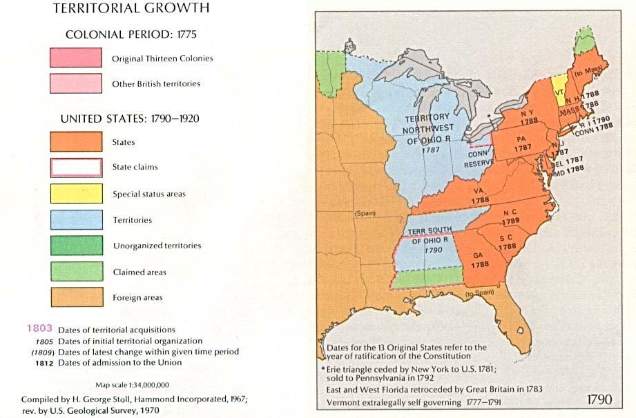
a. The US Territory Northwest of the Ohio River, on the left bank of the Mississippi. b. Spanish Louisiana, on the right bank of the Mississippi. c. An area claimed both by the US and by the Hudson's Bay Company as part of Rupert's Land.
4. Treaty_of_Paris_(1783)#/media/File:United_States_land_claims_and_cessions_1782-1802.png is slightly different from (3) - it shows 'Spanish Possessions' stopping some way south of the souce of the Mississippi - possiboy at the mouth of the Crow Wing River.
#/media/File:United_States_land_claims_and_cessions_1782-1802.png)
5. The 1782 French proposal for the territorial division of North America, which was rejected by the Americans shows the northern boundary of the Spanish Possessions still further south, at the Minnesota River.
Should this issue be mentioned in this article? Alekksandr ( talk) 21:04, 11 April 2020 (UTC)
Veritas caput means "truth" and "head" (whatever that might mean), not "true head". Did Schoolcraft intend the meaning "true head", which would rather be caput verum or if need be verum caput? David Marjanović ( talk) 16:32, 9 December 2020 (UTC)
- This is speculation, but I'm guessing his intention was to create a name that was appealing and vaguely "Indian", and that "veritas caput" was just raw material for that, with its meaning incidental, or at least mostly inspirational. He had a definite aesthetic informed by the way Iroquoian and Algonquian lexemes were borrowed into English, and most of his audience, white Americans, would have been familiar with that same kind of borrowing. Anyway, long story short, the good Latin needs some serious massaging to sound like that kind of borrowing, but itasca is a pretty good approximation. ClockwerkMao ( talk) 23:43, 26 January 2021 (UTC)
- Start-Class vital articles
- Wikipedia level-5 vital articles
- Wikipedia vital articles in Geography
- Start-Class level-5 vital articles
- Wikipedia level-5 vital articles in Geography
- Start-Class vital articles in Geography
- Start-Class Minnesota articles
- Mid-importance Minnesota articles
- Start-Class Lakes articles
- High-importance Lakes articles
- WikiProject Lakes articles
|
| This It is of interest to the following WikiProjects: | ||||||||||||||||||||
| |||||||||||||||||||||
I don't know enough about the Earth science to assess this, but should someone put in a note about there being a dispute as to whether this lake is the Mississippi's source? ("Some people dispute the theory that the Mississippi River source is at Itasca State Park. They claim the source to be the Continental Divide, 15 miles north of Bemidji, Minnesota." http://www.visitbemidji.com/location/contdiv.html) Sh76us 02:45, 8 July 2007 (UTC)
- No!
- There is no serious dispute about this, among knowledgeable scientists. No doubt there are "some people" who dispute this. There are also 'some people' who believe the world is flat -- so what? We don't need to give credence to the theories of every little wackjob cult in Wikipedia.
- P.S. The continental divide is in the Rocky Mountains in Montana & Wyoming, several hundred miles west of Minnesota -- not 15 miles north of Bemidji. That's probably the Northern Divide you're thinking of. T-bonham 10:16, 10 August 2007 (UTC)
I'm currently working on proofreading Schoolcrafts original book for Project Gutenberg, and in Chapter XXII on finding the source of the Mississippi, he refers to "the Itasca Summit" and the "Itascan fork" of the river. That seems to indicate that the term 'Itasca' was already in use at the time. So that raises questions about the story that he wrote Veritas Caput on a map and then it faded so that only itas ca were readable. We ought to have a cite for that story.
- OK, further along in the book, I find Schoolcraft reporting that the Indian name was Elk Lake, and specifically stating that he renamed it as "Itasca Lake". And both the text and labels on his hand-drawn map of the lake clearly say "Itasca".
- So I've changed the text to reflect that, and included a link to that page in his original book.
- I left the 'Veritas Caput' story in the text, but indicated it as an urban legend. Perhaps it should be removed altogether, but if it's a common misperception, having it clarified here is useful. T-bonham 23:41, 10 August 2007 (UTC)
BUT the text of this article repeats the clearly erroneous story about how Schoolcraft made up the word Itasca. This assertion is clearly wrong because the word was widely used as a woman's name long before 1832! Will the author of this article PLEASE change it? - Amy Kastely 6-6-09 —Preceding unsigned comment added by AmyKastely ( talk • contribs) 20:07, 6 June 2009 (UTC)
Originally Schoolcraft named the actual Lake Itasca Schoolcrafts Lake and, as it is indicated on his map, he labelled Elk Lake as Itasca L. When and why did the name Itasca Lake migrate to former Schoolcrafts Lake? -- WWasser ( talk) 16:31, 4 February 2014 (UTC)
Hello fellow Wikipedians,
I have just modified one external link on Lake Itasca. Please take a moment to review my edit. If you have any questions, or need the bot to ignore the links, or the page altogether, please visit this simple FaQ for additional information. I made the following changes:
- Added archive https://web.archive.org/web/20040707013046/http://users.stlcc.edu/jangert/itasca/headwtr.html to http://users.stlcc.edu/jangert/itasca/headwtr.html
When you have finished reviewing my changes, you may follow the instructions on the template below to fix any issues with the URLs.
This message was posted before February 2018.
After February 2018, "External links modified" talk page sections are no longer generated or monitored by InternetArchiveBot. No special action is required regarding these talk page notices, other than
regular verification using the archive tool instructions below. Editors
have permission to delete these "External links modified" talk page sections if they want to de-clutter talk pages, but see the
RfC before doing mass systematic removals. This message is updated dynamically through the template {{
source check}} (last update: 5 June 2024).
- If you have discovered URLs which were erroneously considered dead by the bot, you can report them with this tool.
- If you found an error with any archives or the URLs themselves, you can fix them with this tool.
Cheers.— InternetArchiveBot ( Report bug) 20:44, 15 December 2017 (UTC)
See: -
1. Treaty_of_Paris_(1783)#Consequences - "The actual geography of North America turned out not to match the details used in the treaty ... The treaty stated that the boundary of the United States extended from the "most northwesternmost point" of the Lake of the Woods (now partly in Minnesota, partly in Manitoba, and partly in Ontario) directly westward until it reached the Mississippi River. But in fact the Mississippi does not extend that far northward; the line going west from the Lake of the Woods never intersects the river."
2. Treaty_of_1818#Treaty_provisions - "Article II ... settled a boundary dispute caused by ignorance of actual geography in the boundary agreed to in the 1783 Treaty of Paris that ended the American Revolutionary War. That earlier treaty had placed the boundary between the United States and British North America along a line extending westward from the Lake of the Woods to the Mississippi River. The parties did not realize that the river did not extend that far north, so such a line would never meet the river. In fixing this problem, the 1818 treaty ..."
3. University of Texas map showing the US as of 1790 shows the source of the Mississippi as a tripoint between: -
a. The US Territory Northwest of the Ohio River, on the left bank of the Mississippi. b. Spanish Louisiana, on the right bank of the Mississippi. c. An area claimed both by the US and by the Hudson's Bay Company as part of Rupert's Land.
4. Treaty_of_Paris_(1783)#/media/File:United_States_land_claims_and_cessions_1782-1802.png is slightly different from (3) - it shows 'Spanish Possessions' stopping some way south of the souce of the Mississippi - possiboy at the mouth of the Crow Wing River.
5. The 1782 French proposal for the territorial division of North America, which was rejected by the Americans shows the northern boundary of the Spanish Possessions still further south, at the Minnesota River.
Should this issue be mentioned in this article? Alekksandr ( talk) 21:04, 11 April 2020 (UTC)
Veritas caput means "truth" and "head" (whatever that might mean), not "true head". Did Schoolcraft intend the meaning "true head", which would rather be caput verum or if need be verum caput? David Marjanović ( talk) 16:32, 9 December 2020 (UTC)
- This is speculation, but I'm guessing his intention was to create a name that was appealing and vaguely "Indian", and that "veritas caput" was just raw material for that, with its meaning incidental, or at least mostly inspirational. He had a definite aesthetic informed by the way Iroquoian and Algonquian lexemes were borrowed into English, and most of his audience, white Americans, would have been familiar with that same kind of borrowing. Anyway, long story short, the good Latin needs some serious massaging to sound like that kind of borrowing, but itasca is a pretty good approximation. ClockwerkMao ( talk) 23:43, 26 January 2021 (UTC)
- Start-Class vital articles
- Wikipedia level-5 vital articles
- Wikipedia vital articles in Geography
- Start-Class level-5 vital articles
- Wikipedia level-5 vital articles in Geography
- Start-Class vital articles in Geography
- Start-Class Minnesota articles
- Mid-importance Minnesota articles
- Start-Class Lakes articles
- High-importance Lakes articles
- WikiProject Lakes articles