|
| This It is of interest to the following WikiProjects: | ||||||||||||||||||||||||||
| |||||||||||||||||||||||||||


RainbowBridgeToyko_£ BigdamBridgeArkansa_^LucIano👈🏾°A114~~c208°|c108°| _¡steamgunmissle|vide0| camera80026114:|Ar¡8|🔥•
Does anyone call it the Island of Montreal? Even in the US, it's called the Ile de Montreal. We don't say that Paris includes the Island of the City. -- Zoe
- Well, a Google search turns up more "Island of Montreal"s than "Ile de Montreal"s and "Île de Montréal"s if you limit it to search only English-language pages. -- Brion
- Ha. Well, I guess I'm not in touch with the ignorance of the American people as much as I thought I was. :-) -- Zoe
- (Clearly not -- I'd never even heard of the island in question, in English or in French, before noticing this article. -- Brion)
- What do the Americans have to do with it? (Also, note Île-Bizard, Île Sainte-Hélène...)
- Seriously folks, I've never heard it called anything other than the Island of Montreal or Montreal Island in English, even by someone who uses the French names for other nearby islands. Montreal has a sizable English-speaking minority. - montréalais
montréalais is right. It's the Island of Montreal in English, the Île de Montréal in French. The island had 26 municipalities on it (the largest being the City of Montreal itself) till this year when they were merged into one, so the distinction of the Island versus the City no longer exists. But it will take a while to die out of common speech. - zadcat
- Actually, not quite true, zad - remember that the City contains 75 islands now, including the large ones I mentioned, as well as Île des Soeurs, etc. - montrealais
"...located at the confluence of the St. Lawrence and the Rivière des Outaouais." - Is there a reason that we have the English 'St. Lawrence' (as opposed to St-Laurent) and the French Rivière des Outaouais (as opposed to Ottawa River, its article name)? It seems an odd mix of languages. Radagast 22:12, Jul 8, 2004 (UTC)
- No, there is no reason. - Montréalais 23:40, 8 Jul 2004 (UTC)
- Actually, there is. The Saint Lawrence bears both names, officially, but the bits of the Ottawa river that lie in Québec bears only the name 'Rivière des Outaouais'. (c.f.: http://geonames2.nrcan.gc.ca/cgi-bin/v6/sima_unique_v6?english?EHNAY?C (note that this specifically queries the english name of the feature)). I agree that the mix of names sounds a little silly though, but then it would be more accurate to change Saint Lawrence. - Coren 04:04, Jan 5, 2005 (UTC)
I don't think that's correct. According to National Resources Canada's resources for translators, the Ottawa and Saint Lawrence rivers are two of a limited set of features of pan-Canadian interest that, accordingly, can have their names translated, whereas other features are supposed to have only one form. It's not that those parts of the Ottawa River in Quebec are called Rivière des Outaouais in English -- it's that, unlike other features, it has a name in French and a name in English. - Montréalais 06:32, 5 Jan 2005 (UTC)
A map would be nice.... 85.138.1.15 23:46, 16 October 2006 (UTC)
Can the statement The Champlain Bridge and the Jacques Cartier Bridge together handle 95 million vehicles a year, a volume greater than all of Toronto's and Vancouver's bridges combined be sourced? I'm very skeptical of the figure - Highway 401 crosses three rivers and the Gardiner Expressway and most of the east-west arterials cross both the Humber and the Don. Or perhaps it's counting bridges that cross the municipal boundary only? Peter Grey 18:10, 18 November 2006 (UTC)
{{
reqmapin|Quebec}}
- There is one now. -- Qyd ( talk) 00:31, 24 January 2008 (UTC)
I suggest a new article: List of islands in rivers Peter Horn 14:58, 18 September 2007 (UTC)
Is there another picture available? To someone unfamiliar with the area, it is difficult to discern features on the current snowy one. Greenwool 02:45, 19 October 2007 (UTC)
The Map in the corner is outdated, is shows all the old no longer existing boroughs that ar4e now independent municipalitys. —Preceding unsigned comment added by 74.59.86.218 ( talk) 21:15, 16 September 2008 (UTC)
- Indeed, this map is obsolete as of Jan 1, 2006. Similar obsolete maps still "decorate" many articles related to Montreal. The following map should be substituted. [ http://upload.wikimedia.org/wikipedia/commons/1/10/Montreal-boroughs-post-demerger.png Map Peter Horn 18:41, 18 October 2008 (UTC)
 Island of Montreal (Montreal)

 Peter Horn 18:41, 18 October 2008 (UTC)
Peter Horn
18:58, 18 October 2008 (UTC)
Peter Horn 18:41, 18 October 2008 (UTC)
Peter Horn
18:58, 18 October 2008 (UTC)
- The correct place to discuss this is {{ Location map Canada Montreal}}. Fixed, anyway. -- Qyd ( talk) 20:23, 18 October 2008 (UTC)
Is it possible to get this data somewhere. The current figures (wih defunct link) reflect I believe the are of the Census Division of Montreal which also includes Nun's island, Ile Bizard, Ile Notre Dame, Ile aux Herons, Ile Dorval, Ile Sainte Helene and so on. Would anyone know where to locate the true area of the Island of Montreal?-- Paulalexdij ( talk) 19:54, 10 January 2009 (UTC)
Since nobody has had anything to say about this, I have amended the article to clarify the extent of the only available figure for the area of Ile-de-Montreal. Cheers. -- Paulalexdij ( talk) 12:18, 20 May 2009 (UTC)
The red and blue colour coding on the map in the box at the top right of the page is not, as far as I can see, anywhere explained.
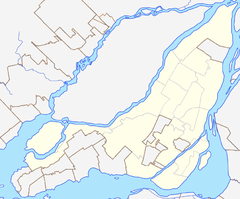
The main map only shows the outline of the island and the districts. The other one shows a big red dot in the larger region, but no local details at all. It gives no sense of the surrounding area or the relative size of the island compared to the rivers, or its surrounding islands. There is a much better map in List of bridges to the Island of Montreal that shows the island, rivers, and surrounding islands, all of which are mentioned in the text but not shown in the maps. I came here because I was curious about how much water there was around Montreal, and didn't find anything, but the other map answered my question immediately. It seems important to me to show the island as part of a local system of rivers and islands, not just a district floating in space. Its not like it's an atoll surrounded by empty ocean. .45Colt 17:55, 20 January 2016 (UTC) .45Colt 17:55, 20 January 2016 (UTC)
Hello fellow Wikipedians,
I have just modified one external link on Island of Montreal. Please take a moment to review my edit. If you have any questions, or need the bot to ignore the links, or the page altogether, please visit this simple FaQ for additional information. I made the following changes:
- Added archive https://web.archive.org/web/20080625074337/http://www.federalbridge.ca/Portals/0/annual_reports/fbcl_report_2006-07_eng.pdf to http://www.federalbridge.ca/Portals/0/annual_reports/fbcl_report_2006-07_eng.pdf
When you have finished reviewing my changes, you may follow the instructions on the template below to fix any issues with the URLs.
This message was posted before February 2018.
After February 2018, "External links modified" talk page sections are no longer generated or monitored by InternetArchiveBot. No special action is required regarding these talk page notices, other than
regular verification using the archive tool instructions below. Editors
have permission to delete these "External links modified" talk page sections if they want to de-clutter talk pages, but see the
RfC before doing mass systematic removals. This message is updated dynamically through the template {{
source check}} (last update: 5 June 2024).
- If you have discovered URLs which were erroneously considered dead by the bot, you can report them with this tool.
- If you found an error with any archives or the URLs themselves, you can fix them with this tool.
Cheers.— InternetArchiveBot ( Report bug) 11:17, 17 November 2017 (UTC)
- Start-Class vital articles
- Wikipedia level-5 vital articles
- Wikipedia vital articles in Geography
- Start-Class level-5 vital articles
- Wikipedia level-5 vital articles in Geography
- Start-Class vital articles in Geography
- Start-Class geography articles
- Unknown-importance geography articles
- WikiProject Geography articles
- Start-Class Canada-related articles
- Mid-importance Canada-related articles
- Start-Class Quebec articles
- Mid-importance Quebec articles
- Start-Class Geography of Canada articles
- Mid-importance Geography of Canada articles
- All WikiProject Canada pages
- Start-Class Montreal articles
- High-importance Montreal articles
- WikiProject Montreal articles
|
| This It is of interest to the following WikiProjects: | |||||||||||||||||||||||||||||||||||||||||||
| ||||||||||||||||||||||||||||||||||||||||||||
RainbowBridgeToyko_£ BigdamBridgeArkansa_^LucIano👈🏾°A114~~c208°|c108°| _¡steamgunmissle|vide0| camera80026114:|Ar¡8|🔥•
Does anyone call it the Island of Montreal? Even in the US, it's called the Ile de Montreal. We don't say that Paris includes the Island of the City. -- Zoe
- Well, a Google search turns up more "Island of Montreal"s than "Ile de Montreal"s and "Île de Montréal"s if you limit it to search only English-language pages. -- Brion
- Ha. Well, I guess I'm not in touch with the ignorance of the American people as much as I thought I was. :-) -- Zoe
- (Clearly not -- I'd never even heard of the island in question, in English or in French, before noticing this article. -- Brion)
- What do the Americans have to do with it? (Also, note Île-Bizard, Île Sainte-Hélène...)
- Seriously folks, I've never heard it called anything other than the Island of Montreal or Montreal Island in English, even by someone who uses the French names for other nearby islands. Montreal has a sizable English-speaking minority. - montréalais
montréalais is right. It's the Island of Montreal in English, the Île de Montréal in French. The island had 26 municipalities on it (the largest being the City of Montreal itself) till this year when they were merged into one, so the distinction of the Island versus the City no longer exists. But it will take a while to die out of common speech. - zadcat
- Actually, not quite true, zad - remember that the City contains 75 islands now, including the large ones I mentioned, as well as Île des Soeurs, etc. - montrealais
"...located at the confluence of the St. Lawrence and the Rivière des Outaouais." - Is there a reason that we have the English 'St. Lawrence' (as opposed to St-Laurent) and the French Rivière des Outaouais (as opposed to Ottawa River, its article name)? It seems an odd mix of languages. Radagast 22:12, Jul 8, 2004 (UTC)
- No, there is no reason. - Montréalais 23:40, 8 Jul 2004 (UTC)
- Actually, there is. The Saint Lawrence bears both names, officially, but the bits of the Ottawa river that lie in Québec bears only the name 'Rivière des Outaouais'. (c.f.: http://geonames2.nrcan.gc.ca/cgi-bin/v6/sima_unique_v6?english?EHNAY?C (note that this specifically queries the english name of the feature)). I agree that the mix of names sounds a little silly though, but then it would be more accurate to change Saint Lawrence. - Coren 04:04, Jan 5, 2005 (UTC)
I don't think that's correct. According to National Resources Canada's resources for translators, the Ottawa and Saint Lawrence rivers are two of a limited set of features of pan-Canadian interest that, accordingly, can have their names translated, whereas other features are supposed to have only one form. It's not that those parts of the Ottawa River in Quebec are called Rivière des Outaouais in English -- it's that, unlike other features, it has a name in French and a name in English. - Montréalais 06:32, 5 Jan 2005 (UTC)
A map would be nice.... 85.138.1.15 23:46, 16 October 2006 (UTC)
Can the statement The Champlain Bridge and the Jacques Cartier Bridge together handle 95 million vehicles a year, a volume greater than all of Toronto's and Vancouver's bridges combined be sourced? I'm very skeptical of the figure - Highway 401 crosses three rivers and the Gardiner Expressway and most of the east-west arterials cross both the Humber and the Don. Or perhaps it's counting bridges that cross the municipal boundary only? Peter Grey 18:10, 18 November 2006 (UTC)
{{
reqmapin|Quebec}}
- There is one now. -- Qyd ( talk) 00:31, 24 January 2008 (UTC)
I suggest a new article: List of islands in rivers Peter Horn 14:58, 18 September 2007 (UTC)
Is there another picture available? To someone unfamiliar with the area, it is difficult to discern features on the current snowy one. Greenwool 02:45, 19 October 2007 (UTC)
The Map in the corner is outdated, is shows all the old no longer existing boroughs that ar4e now independent municipalitys. —Preceding unsigned comment added by 74.59.86.218 ( talk) 21:15, 16 September 2008 (UTC)
- Indeed, this map is obsolete as of Jan 1, 2006. Similar obsolete maps still "decorate" many articles related to Montreal. The following map should be substituted. [ http://upload.wikimedia.org/wikipedia/commons/1/10/Montreal-boroughs-post-demerger.png Map Peter Horn 18:41, 18 October 2008 (UTC)Island of Montreal (Montreal)
Peter Horn 18:41, 18 October 2008 (UTC)
Peter Horn
18:58, 18 October 2008 (UTC)
- The correct place to discuss this is {{ Location map Canada Montreal}}. Fixed, anyway. -- Qyd ( talk) 20:23, 18 October 2008 (UTC)
Is it possible to get this data somewhere. The current figures (wih defunct link) reflect I believe the are of the Census Division of Montreal which also includes Nun's island, Ile Bizard, Ile Notre Dame, Ile aux Herons, Ile Dorval, Ile Sainte Helene and so on. Would anyone know where to locate the true area of the Island of Montreal?-- Paulalexdij ( talk) 19:54, 10 January 2009 (UTC)
Since nobody has had anything to say about this, I have amended the article to clarify the extent of the only available figure for the area of Ile-de-Montreal. Cheers. -- Paulalexdij ( talk) 12:18, 20 May 2009 (UTC)
The red and blue colour coding on the map in the box at the top right of the page is not, as far as I can see, anywhere explained.
The main map only shows the outline of the island and the districts. The other one shows a big red dot in the larger region, but no local details at all. It gives no sense of the surrounding area or the relative size of the island compared to the rivers, or its surrounding islands. There is a much better map in List of bridges to the Island of Montreal that shows the island, rivers, and surrounding islands, all of which are mentioned in the text but not shown in the maps. I came here because I was curious about how much water there was around Montreal, and didn't find anything, but the other map answered my question immediately. It seems important to me to show the island as part of a local system of rivers and islands, not just a district floating in space. Its not like it's an atoll surrounded by empty ocean. .45Colt 17:55, 20 January 2016 (UTC) .45Colt 17:55, 20 January 2016 (UTC)
Hello fellow Wikipedians,
I have just modified one external link on Island of Montreal. Please take a moment to review my edit. If you have any questions, or need the bot to ignore the links, or the page altogether, please visit this simple FaQ for additional information. I made the following changes:
- Added archive https://web.archive.org/web/20080625074337/http://www.federalbridge.ca/Portals/0/annual_reports/fbcl_report_2006-07_eng.pdf to http://www.federalbridge.ca/Portals/0/annual_reports/fbcl_report_2006-07_eng.pdf
When you have finished reviewing my changes, you may follow the instructions on the template below to fix any issues with the URLs.
This message was posted before February 2018.
After February 2018, "External links modified" talk page sections are no longer generated or monitored by InternetArchiveBot. No special action is required regarding these talk page notices, other than
regular verification using the archive tool instructions below. Editors
have permission to delete these "External links modified" talk page sections if they want to de-clutter talk pages, but see the
RfC before doing mass systematic removals. This message is updated dynamically through the template {{
source check}} (last update: 5 June 2024).
- If you have discovered URLs which were erroneously considered dead by the bot, you can report them with this tool.
- If you found an error with any archives or the URLs themselves, you can fix them with this tool.
Cheers.— InternetArchiveBot ( Report bug) 11:17, 17 November 2017 (UTC)
- Start-Class vital articles
- Wikipedia level-5 vital articles
- Wikipedia vital articles in Geography
- Start-Class level-5 vital articles
- Wikipedia level-5 vital articles in Geography
- Start-Class vital articles in Geography
- Start-Class geography articles
- Unknown-importance geography articles
- WikiProject Geography articles
- Start-Class Canada-related articles
- Mid-importance Canada-related articles
- Start-Class Quebec articles
- Mid-importance Quebec articles
- Start-Class Geography of Canada articles
- Mid-importance Geography of Canada articles
- All WikiProject Canada pages
- Start-Class Montreal articles
- High-importance Montreal articles
- WikiProject Montreal articles