|
| This article is rated Start-class on Wikipedia's
content assessment scale. It is of interest to the following WikiProjects: | ||||||||||
| |||||||||||

I rated the page as Start quality (lack of clarity, reference, language is not correct... and importance middle as it receives in average 300 view per day). User:baptisteg
I do not want to provoke an edit war, so I have applied the NPOV principle to the main article, but I firmly disagree with the POV that Gangkhar Puensum is wholly in Bhutan.
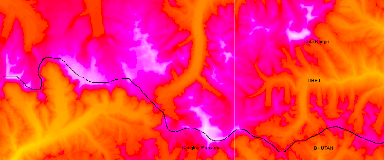
The local border with Tibet is a sensitive issue, but in the relevant area it can only take one logical course, the watershed divide. This clearly runs over the Gangkhar Puensum mountain. It follows that if the summit is wholly in Bhutan, then it would have to be on a spur, removed from the divide. A photograph taken of the main summit from Liangkang Kangri, a subsidiary top to the north, shows that the main summit is clean, with no such spur. It therefore follows that, in the absence of any formal agreement with China, the main summit is on the border, and NOT the exclusive possession of Bhutan.
It is worth noting that the 1986 Berry book was written at the time when the local topography was much less clear, but it is likely that the POV expressed there has been widely reproduced. Viewfinder 00:19, 10 January 2006 (UTC)
- I think what you have put now summarises the situation just fine. It seems that China and Bhutan have decided that their border disputes are not worth a war so surely an edit war is not justified here either! The Gangkhar Puensum article is careful in quoting sources claiming what is on what side of the border. That article itself does not state a point of view other than by saying "the highest mountain in Bhutan" it claims that the summit is in Bhutan or on the border with Tibet (China). My personal (and unprofessional) POV is that Kula Kangri (a higher mountain) is on the border and GP is in Bhutan. However, where the border is not definitely agreed, and where some maps muddle up KK and GP, this can only be rather unclear. BTW I'd love to know the prominence of GP! Thincat 09:50, 10 January 2006 (UTC)
The prominence of GP depends on its elevation relative to Kula Kangri. The prominences shown here are based on the assumption that Kula Kangri is lower. I cannot prove this, but in the absence of any modern and accurate measurements other than the Chinese ones, I accept the Chinese claim that Gangkhar Puensum is 7570m and that Kula Kangri is lower at 7538m. The course of the watershed border is shown on a web page that I have created, and I draw specific attention to the map. A border that includes Kula Kangri but passes north of Gangkhar Puensum deviates from the watershed border and makes no topographic sense. The extra Bhutanese territory that such a border creates is completely uninhabited. The only valley that would be included would be cut off from the rest of Bhutan by impenetrable mountains and glaciers. So what legal or other basis for such a border can there be? Viewfinder 13:28, 10 January 2006 (UTC)
The first recorded ascent of any mountain in the American West was Gray Back Peak (southwest of Colorado Springs, Colorado, by Zebulon Pike, Private Theodore Miller, Dr. John Robinson, and Private John Brown, on November 26, 1806. The next day the four climbers ascended Mt.Rosa, 11,499' which was the first recorded ascent of any American mountain into the Alpine zone. They were trying to ascend Pikes Peak, and gave up on the summit of Rosa, still 8 miles from their objective. Google " Zebulon Pike, Murphy, Mt. Rosa" for more details. John Murphy Pike historian — Preceding unsigned comment added by 76.25.184.188 ( talk) 19:26, 5 December 2012 (UTC)
From the current Wikipedia article introduction.
"Kangchenjunga was first climbed on 25 May 1955 by Joe Brown and George Band, who were part of a British expedition. They stopped short of the summit as per the promise given to the Chogyal that the top of the mountain would remain inviolate. Every climber or climbing group that has reached the summit has followed this tradition.[7]"
That sounds like not climbed to me, however easily the remaining elevation could have been climbed, it wasn't. AnnaComnemna ( talk) 19:47, 4 March 2015 (UTC)
- I think since that time people have become rather less respectful. [1] Thincat ( talk) 20:31, 4 March 2015 (UTC)
- I am almost certain the practice of stopping a few feet short of the actual summit out respect for local beliefs is accepted in the climbing community as a completely valid ascent. We could announce the peak as the "world's highest unclimbed mountain" based on this technicality, but at best it probably wouldn't mean anything to the people who actually intend to climb such mountains. At worst, it would encourage the next summitting climber to simply step a foot on the highest point, defeating the purpose of the tradition.
- But as Thincat has pointed out, the question now appears to be moot in any case. The following is from a source concerning the practice in question:
- "The first assault pair of Joe Brown and George Band are successful, followed by a second successful ascent by Norman Hardie and Tony Streather. Out of respect for local beliefs, the actual summit itself remained virgin, a tradition that continued until recent years." - EverestNews.com
- Key words here "until recent years". This seems to imply that lately, climbers have dropped the tradition and now ascend to the highest point of the mountain. -- RacerX11 Talk to me Stalk me 23:03, 4 March 2015 (UTC)
"is accepted in the climbing community" Sorry, the climbing community does not have the casting vote on what appears in Wikipedia, and no vote at all on what constitutes reality. But let it stand. Does this tradition, whether observed more in the breach or not, extend to other mountains? And if it does, what changes need to be made to other articles? AnnaComnemna ( talk) 13:35, 11 March 2015 (UTC)
One of the unclimbed phenomena in the world needs to be added Salmanlla ( talk) 04:17, 8 June 2016 (UTC)
- (wl:
Imaginatorium (
talk)
07:08, 8 December 2016 (UTC))
- Done Not Sure ( talk) 20:14, 26 June 2023 (UTC)
Regarding summitting, I think the early climbers of Kangchenjunga specifically said they did not set foot on the summit but they were nevertheless credited with climbing the mountain successfully. However, later expeditions have, I think, not continued this restraint (see earlier in this talk page). Nanda Devi is a different matter.The article is correctly quoting the given source [2] but I think the information is wrong. In writing Shipton–Tilman Nanda Devi expeditions I never came across any suggestion that Tilman and Odell did not set foot on the very top. They certainly claimed that they did and I don't think it has been disputed. In Tilman, H W (2014). The Ascent of Nanda Devi (Kindle). ISBN 978-1-910240-15-1. there is a detailed description of the summit (a comparative plateau). [3] It's always difficult to know how to deal with a conflict in sources (disfavoured claim in footnote?) so I'll leave this for now. Anyway, a thoroughly worthwhile rewrite of the article. Thincat ( talk) 20:30, 16 March 2018 (UTC)
- I adjusted this per your comments. I know when I did some climbing in Glacier National park, (US) a few decades ago, the one Blackfoot person I knew had asked me to avoid the last few feet of most of the peaks in the eastern section of the park, as this was the abode of spirits. The prohibition from fully summiting many peaks based on spiritual/religious beliefs of natives is not rare. However, its likely many would just say they did avoid setting foot on the highest summit to appease locals when in fact they most likely did fully ascend the peaks.-- MONGO 14:32, 19 March 2018 (UTC)
As mentioned before in my edit summaries, the highest point of Kabru appears to have been reached repeatedly. Since we don't want to get people organizing an expedition for no satisfying reason, let's be sure about this;-) We have a very good map of the western half of Kabru, showing the main summit towards the north end of the massif (p. 7412 at 27°38'03"N 88°07'06"E) and a point 7318 in the south west at 27°36'31"N 88°06'41"E. The saddle in between is no lower than c. 7220 m. The relief on google maps corresponds nicely to the map these days. There are some intermediate bumps around 27°37'17"N 88°06'56"E not check pointed by the Nepal survey and some across the border. Google maps suggest that they are a bit higher than the south summit but with a prominence of at best 80 m. The Himalayan Index (search for Kabru*) Has a very confusing set of peaks.
- Kabru II (aka Kabru N and Kabru I) is the high summit (7412 m) climbed in 1935, 1994 and 2008, and perhaps as early as 1883! Unfortunately, their coordinates are 1 km off to the SE.
- Kabru III (aka Kabru IV) has a height assigned of 7353 and was also climbed in the 1994 expedition. Assuming the same 1 km mismatch as the main peak, this corresponds nicely to the highest bump with a <80 m prominence mentioned above.
- Kabru IV (aka Kabru III and Kabru S) with a height of 7318 m is considered unclimbed. It has coordinates that put it 1.5 km west of the 7318 m south summit.
- Kabru S (aka Kabru I) is the one you see on the picture. The Himalayan Index gives it a height of 7317 m (close enough) and oddly places it 1 km due south of the south summit, rather than southwest. It was climbed by that same expedition in 1994 and (impressively) over the West face in 2004.
- Kabru Dome is the nose on the ridge on the picture (6600 m high) and climbed in 1982 and 1985
From this I tend to think that there are no unclimbed main summits on Kabru anymore. Kabru IV and Kabru S are probably the same peak. Do you have references to suggest otherwise, and which summit would it be? Afasmit ( talk) 19:47, 3 May 2018 (UTC)
MONGO, could you clarify what you think the is issue with the list of unclimbed mountains and its sourcing? What is so unreliable about 8000ers.com, and how is Afasmit identifiable as its author? (I'm assuming that's who you mean by "subject" - since the subject of this article is not a person...) At face value, that seems to me to be wholly acceptable sourcing for the information. -- Elmidae ( talk · contribs) 16:18, 11 December 2018 (UTC)
- I am not Eberhard Jurgalski and have nothing to do with the 8000ers.com site. Back in 2005-2006,
Viewfinder helped me a lot to optimize the
list of highest mountains that I'd created as IP 67.161.117.149. He and Eberhard had collaborated on many mountain height-related projects and we had a handful of three-way email exchanges. Jurgalski was building his (much more detailed) list of highest mountains around the same time and his first public version may have come out in 2006; we sometimes considered different maps and sources more accurate and reliable (I still think I was right on the Hispar Karakoram;-), but of course they match well otherwise. Since then he's set up his 8000ers.com site and has remained the authority on high Asia mountain heights and possibly of their first ascents as well. He's updated his list many times and as recently as last August. In fact, I should look if the wikipedia list needs some updates. I'd be surprised if there is a better source and reference for the highest unclimbed mountains (though deciding that the unclimbed Apsarasas III is the highest of the Apsarasas peaks by 2 meters feels rather iffy;-).
Afasmit (
talk)
19:57, 11 December 2018 (UTC)
- Well, involvement in the origin of material is no Mark of Cain, as long as the result is considered reliable by a sufficient number of people. I'm not seeing an indication to the contrary here. -- Elmidae ( talk · contribs) 08:12, 12 December 2018 (UTC)
- Sorry if my edit summary wording seemed to indicate that I thought anyone here was the publisher of those references as this is not what I wanted to convey. I am not adamant about not having this material, but since it appears to be self published I am not convinced it is reliable enough to be included as discussed under the relevant policy here. I can be persuaded otherwise.-- MONGO ( talk) 13:27, 12 December 2018 (UTC)
- I am leaning against this material, especially the way the author is mentioned as if he is a published reliable source. However, if it is kept we need to add the rest of the measurement conversions as I started doing.--
MONGO (
talk)
13:47, 12 December 2018 (UTC)
- I've put the feet up. I think Jurgalski passes the self published sources test, as he is a published author on the subject. Afasmit ( talk) 19:27, 12 December 2018 (UTC)
- Some further assessment from people who know which way is up on a mountain (i.e. not me) may be useful. I'll drop a note at Wikipedia:WikiProject Climbing. -- Elmidae ( talk · contribs) 19:47, 12 December 2018 (UTC)
The article title is about "unclimbed" mountains, but the body talks about people not having reached the peaks of these mountains. In fact, the article says that many of the mountains listed have been climbed before, just not to the summits. Is this some distinct usage of "climbed" to indicate that someone has successfully reached the peak? Opencooper ( talk) 18:14, 30 June 2023 (UTC)
- Your question is somewhat mistaken in its approach to the subject. If I ask "Have you swept the floor?" and you've swept just one corner, you must answer "No". You can only answer "Yes" if you've swept the *whole* floor. "Have you climbed the mountain?" works the same way - everybody knows you can't answer "Yes" unless you've climbed it all the way. TooManyFingers ( talk) 04:26, 21 May 2024 (UTC)
https://reddit.com/r/hiking/s/D7C5sqHuPQ 82.56.18.69 ( talk) 15:19, 11 September 2023 (UTC)
|
| This article is rated Start-class on Wikipedia's
content assessment scale. It is of interest to the following WikiProjects: | ||||||||||
| |||||||||||
I rated the page as Start quality (lack of clarity, reference, language is not correct... and importance middle as it receives in average 300 view per day). User:baptisteg
I do not want to provoke an edit war, so I have applied the NPOV principle to the main article, but I firmly disagree with the POV that Gangkhar Puensum is wholly in Bhutan.
The local border with Tibet is a sensitive issue, but in the relevant area it can only take one logical course, the watershed divide. This clearly runs over the Gangkhar Puensum mountain. It follows that if the summit is wholly in Bhutan, then it would have to be on a spur, removed from the divide. A photograph taken of the main summit from Liangkang Kangri, a subsidiary top to the north, shows that the main summit is clean, with no such spur. It therefore follows that, in the absence of any formal agreement with China, the main summit is on the border, and NOT the exclusive possession of Bhutan.
It is worth noting that the 1986 Berry book was written at the time when the local topography was much less clear, but it is likely that the POV expressed there has been widely reproduced. Viewfinder 00:19, 10 January 2006 (UTC)
- I think what you have put now summarises the situation just fine. It seems that China and Bhutan have decided that their border disputes are not worth a war so surely an edit war is not justified here either! The Gangkhar Puensum article is careful in quoting sources claiming what is on what side of the border. That article itself does not state a point of view other than by saying "the highest mountain in Bhutan" it claims that the summit is in Bhutan or on the border with Tibet (China). My personal (and unprofessional) POV is that Kula Kangri (a higher mountain) is on the border and GP is in Bhutan. However, where the border is not definitely agreed, and where some maps muddle up KK and GP, this can only be rather unclear. BTW I'd love to know the prominence of GP! Thincat 09:50, 10 January 2006 (UTC)
The prominence of GP depends on its elevation relative to Kula Kangri. The prominences shown here are based on the assumption that Kula Kangri is lower. I cannot prove this, but in the absence of any modern and accurate measurements other than the Chinese ones, I accept the Chinese claim that Gangkhar Puensum is 7570m and that Kula Kangri is lower at 7538m. The course of the watershed border is shown on a web page that I have created, and I draw specific attention to the map. A border that includes Kula Kangri but passes north of Gangkhar Puensum deviates from the watershed border and makes no topographic sense. The extra Bhutanese territory that such a border creates is completely uninhabited. The only valley that would be included would be cut off from the rest of Bhutan by impenetrable mountains and glaciers. So what legal or other basis for such a border can there be? Viewfinder 13:28, 10 January 2006 (UTC)
The first recorded ascent of any mountain in the American West was Gray Back Peak (southwest of Colorado Springs, Colorado, by Zebulon Pike, Private Theodore Miller, Dr. John Robinson, and Private John Brown, on November 26, 1806. The next day the four climbers ascended Mt.Rosa, 11,499' which was the first recorded ascent of any American mountain into the Alpine zone. They were trying to ascend Pikes Peak, and gave up on the summit of Rosa, still 8 miles from their objective. Google " Zebulon Pike, Murphy, Mt. Rosa" for more details. John Murphy Pike historian — Preceding unsigned comment added by 76.25.184.188 ( talk) 19:26, 5 December 2012 (UTC)
From the current Wikipedia article introduction.
"Kangchenjunga was first climbed on 25 May 1955 by Joe Brown and George Band, who were part of a British expedition. They stopped short of the summit as per the promise given to the Chogyal that the top of the mountain would remain inviolate. Every climber or climbing group that has reached the summit has followed this tradition.[7]"
That sounds like not climbed to me, however easily the remaining elevation could have been climbed, it wasn't. AnnaComnemna ( talk) 19:47, 4 March 2015 (UTC)
- I think since that time people have become rather less respectful. [1] Thincat ( talk) 20:31, 4 March 2015 (UTC)
- I am almost certain the practice of stopping a few feet short of the actual summit out respect for local beliefs is accepted in the climbing community as a completely valid ascent. We could announce the peak as the "world's highest unclimbed mountain" based on this technicality, but at best it probably wouldn't mean anything to the people who actually intend to climb such mountains. At worst, it would encourage the next summitting climber to simply step a foot on the highest point, defeating the purpose of the tradition.
- But as Thincat has pointed out, the question now appears to be moot in any case. The following is from a source concerning the practice in question:
- "The first assault pair of Joe Brown and George Band are successful, followed by a second successful ascent by Norman Hardie and Tony Streather. Out of respect for local beliefs, the actual summit itself remained virgin, a tradition that continued until recent years." - EverestNews.com
- Key words here "until recent years". This seems to imply that lately, climbers have dropped the tradition and now ascend to the highest point of the mountain. -- RacerX11 Talk to me Stalk me 23:03, 4 March 2015 (UTC)
"is accepted in the climbing community" Sorry, the climbing community does not have the casting vote on what appears in Wikipedia, and no vote at all on what constitutes reality. But let it stand. Does this tradition, whether observed more in the breach or not, extend to other mountains? And if it does, what changes need to be made to other articles? AnnaComnemna ( talk) 13:35, 11 March 2015 (UTC)
One of the unclimbed phenomena in the world needs to be added Salmanlla ( talk) 04:17, 8 June 2016 (UTC)
- (wl:
Imaginatorium (
talk)
07:08, 8 December 2016 (UTC))
- Done Not Sure ( talk) 20:14, 26 June 2023 (UTC)
Regarding summitting, I think the early climbers of Kangchenjunga specifically said they did not set foot on the summit but they were nevertheless credited with climbing the mountain successfully. However, later expeditions have, I think, not continued this restraint (see earlier in this talk page). Nanda Devi is a different matter.The article is correctly quoting the given source [2] but I think the information is wrong. In writing Shipton–Tilman Nanda Devi expeditions I never came across any suggestion that Tilman and Odell did not set foot on the very top. They certainly claimed that they did and I don't think it has been disputed. In Tilman, H W (2014). The Ascent of Nanda Devi (Kindle). ISBN 978-1-910240-15-1. there is a detailed description of the summit (a comparative plateau). [3] It's always difficult to know how to deal with a conflict in sources (disfavoured claim in footnote?) so I'll leave this for now. Anyway, a thoroughly worthwhile rewrite of the article. Thincat ( talk) 20:30, 16 March 2018 (UTC)
- I adjusted this per your comments. I know when I did some climbing in Glacier National park, (US) a few decades ago, the one Blackfoot person I knew had asked me to avoid the last few feet of most of the peaks in the eastern section of the park, as this was the abode of spirits. The prohibition from fully summiting many peaks based on spiritual/religious beliefs of natives is not rare. However, its likely many would just say they did avoid setting foot on the highest summit to appease locals when in fact they most likely did fully ascend the peaks.-- MONGO 14:32, 19 March 2018 (UTC)
As mentioned before in my edit summaries, the highest point of Kabru appears to have been reached repeatedly. Since we don't want to get people organizing an expedition for no satisfying reason, let's be sure about this;-) We have a very good map of the western half of Kabru, showing the main summit towards the north end of the massif (p. 7412 at 27°38'03"N 88°07'06"E) and a point 7318 in the south west at 27°36'31"N 88°06'41"E. The saddle in between is no lower than c. 7220 m. The relief on google maps corresponds nicely to the map these days. There are some intermediate bumps around 27°37'17"N 88°06'56"E not check pointed by the Nepal survey and some across the border. Google maps suggest that they are a bit higher than the south summit but with a prominence of at best 80 m. The Himalayan Index (search for Kabru*) Has a very confusing set of peaks.
- Kabru II (aka Kabru N and Kabru I) is the high summit (7412 m) climbed in 1935, 1994 and 2008, and perhaps as early as 1883! Unfortunately, their coordinates are 1 km off to the SE.
- Kabru III (aka Kabru IV) has a height assigned of 7353 and was also climbed in the 1994 expedition. Assuming the same 1 km mismatch as the main peak, this corresponds nicely to the highest bump with a <80 m prominence mentioned above.
- Kabru IV (aka Kabru III and Kabru S) with a height of 7318 m is considered unclimbed. It has coordinates that put it 1.5 km west of the 7318 m south summit.
- Kabru S (aka Kabru I) is the one you see on the picture. The Himalayan Index gives it a height of 7317 m (close enough) and oddly places it 1 km due south of the south summit, rather than southwest. It was climbed by that same expedition in 1994 and (impressively) over the West face in 2004.
- Kabru Dome is the nose on the ridge on the picture (6600 m high) and climbed in 1982 and 1985
From this I tend to think that there are no unclimbed main summits on Kabru anymore. Kabru IV and Kabru S are probably the same peak. Do you have references to suggest otherwise, and which summit would it be? Afasmit ( talk) 19:47, 3 May 2018 (UTC)
MONGO, could you clarify what you think the is issue with the list of unclimbed mountains and its sourcing? What is so unreliable about 8000ers.com, and how is Afasmit identifiable as its author? (I'm assuming that's who you mean by "subject" - since the subject of this article is not a person...) At face value, that seems to me to be wholly acceptable sourcing for the information. -- Elmidae ( talk · contribs) 16:18, 11 December 2018 (UTC)
- I am not Eberhard Jurgalski and have nothing to do with the 8000ers.com site. Back in 2005-2006,
Viewfinder helped me a lot to optimize the
list of highest mountains that I'd created as IP 67.161.117.149. He and Eberhard had collaborated on many mountain height-related projects and we had a handful of three-way email exchanges. Jurgalski was building his (much more detailed) list of highest mountains around the same time and his first public version may have come out in 2006; we sometimes considered different maps and sources more accurate and reliable (I still think I was right on the Hispar Karakoram;-), but of course they match well otherwise. Since then he's set up his 8000ers.com site and has remained the authority on high Asia mountain heights and possibly of their first ascents as well. He's updated his list many times and as recently as last August. In fact, I should look if the wikipedia list needs some updates. I'd be surprised if there is a better source and reference for the highest unclimbed mountains (though deciding that the unclimbed Apsarasas III is the highest of the Apsarasas peaks by 2 meters feels rather iffy;-).
Afasmit (
talk)
19:57, 11 December 2018 (UTC)
- Well, involvement in the origin of material is no Mark of Cain, as long as the result is considered reliable by a sufficient number of people. I'm not seeing an indication to the contrary here. -- Elmidae ( talk · contribs) 08:12, 12 December 2018 (UTC)
- Sorry if my edit summary wording seemed to indicate that I thought anyone here was the publisher of those references as this is not what I wanted to convey. I am not adamant about not having this material, but since it appears to be self published I am not convinced it is reliable enough to be included as discussed under the relevant policy here. I can be persuaded otherwise.-- MONGO ( talk) 13:27, 12 December 2018 (UTC)
- I am leaning against this material, especially the way the author is mentioned as if he is a published reliable source. However, if it is kept we need to add the rest of the measurement conversions as I started doing.--
MONGO (
talk)
13:47, 12 December 2018 (UTC)
- I've put the feet up. I think Jurgalski passes the self published sources test, as he is a published author on the subject. Afasmit ( talk) 19:27, 12 December 2018 (UTC)
- Some further assessment from people who know which way is up on a mountain (i.e. not me) may be useful. I'll drop a note at Wikipedia:WikiProject Climbing. -- Elmidae ( talk · contribs) 19:47, 12 December 2018 (UTC)
The article title is about "unclimbed" mountains, but the body talks about people not having reached the peaks of these mountains. In fact, the article says that many of the mountains listed have been climbed before, just not to the summits. Is this some distinct usage of "climbed" to indicate that someone has successfully reached the peak? Opencooper ( talk) 18:14, 30 June 2023 (UTC)
- Your question is somewhat mistaken in its approach to the subject. If I ask "Have you swept the floor?" and you've swept just one corner, you must answer "No". You can only answer "Yes" if you've swept the *whole* floor. "Have you climbed the mountain?" works the same way - everybody knows you can't answer "Yes" unless you've climbed it all the way. TooManyFingers ( talk) 04:26, 21 May 2024 (UTC)
https://reddit.com/r/hiking/s/D7C5sqHuPQ 82.56.18.69 ( talk) 15:19, 11 September 2023 (UTC)