|
| This It is of interest to the following WikiProjects: | |||||||||||||||||||||||||||
| ||||||||||||||||||||||||||||


Agreed Budgiekiller 14:45, September 1, 2005 (UTC)
The article Datum has been successfully merged into this article. Also there is a proposed plan to merge this article into Geodesy. I agree to merge this article into the sub-section in Geodesy called Geodetic datums. -- Zer_T 01:35, 16 December 2005 (UTC)
As I am not a cartographer I will not edit the page. More than one datum requires the plural, which is data. Reg nim 20:40, 19 December 2006 (UTC)
Maybe the page has been edited by others to change it, becaue I find the word data in some places where I would expect datums (e.g. geodetic data). Or maybe I've misunderstood something. — Preceding unsigned comment added by 217.12.16.53 ( talk • contribs) 06:51, 25 August 2009
- Geodetic data refers to the geographical coordinates of every place on Earth, but geodetic datums refer to the several reference surfaces along which geodetic data are measured. — Joe Kress ( talk) 17:16, 25 August 2009 (UTC)
Saying that a datum is a reference system is like saying that a telephone is a communication device -- it just doesn't tell you much. Is a datum a mathematical representation (ellipsoid)? If not, how does it differ from an ellipsoid representation? — Preceding unsigned comment added by 2600:1014:B12B:9DD9:AD12:18BE:CD58:1195 ( talk) 12:33, 29 June 2015 (UTC)
There should be discussion of the GEOID in this article for better background. Also, there are several publically available documents, and spreadsheets enabling the conversions from XYZ to Lat Long Height. (polar coords, with deference to the ellipsoid)
references to Peter Dana's other work would be useful
http://www.colorado.edu/geography/gcraft/notes/coordsys/coordsys_f.html
14:50, 3 April 2007 (UTC)
It would be helpful to add a note to the sections with the geodetic-geocentric-cartesian transformations to indicate what % of error is introduced by the equations. Users will then know whether they can expect tranformations using these formulae to be accurate within 1m, 1cm, etc. DiscipleOfChrist 16:37, 15 May 2007 (UTC)
It would be helpful to define h in the formulae for conversion from geodetic coordinates to ECEF. Is it PR in the diagram (height above mean sea level), or QR (height above the point where the normal intersects the axis)?
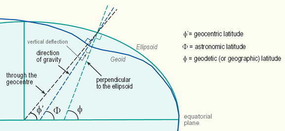
Whether is clear the definition of Geodetic and Geocentric latitude and the related conversion formulas, it is not clear which of the two definitions is assumed as reference for the WGS84 standard. In the pdf (linked to this page) describing the standard, both definitions are used for different computations. It seems that in all computations related to gravity, the geocentric latitude is more convenient than geodetic, where in all local computations related to targets localization the geodetic one is mostly used, likely because targets which share the same projection on the (ellipsoidal) Earth surface but having different altitudes, will not change their latitude, leaving the independency among the Lat/Long coordinates and the Altitude. However, it is elsewhere reported that the GPS (based upon the WGS84) does use the geocentric latitude definition. Someone knows specifically (apart from the obvious remark that the World GEODETIC system should follow Geodetic Lat/Long coordinates) which is the official Lat/Long definition for WGS84? 81.208.53.251 12:50, 31 July 2007 (UTC)Paolo, Rome 31-07-2007 81.208.53.251 12:50, 31 July 2007 (UTC)
Which latitude is which?
In all navigation applications (including GPS) latitude is geodetic latitude. This is because geodetic latitude is measured with respect to the horizon whereas geocentric latitude is requires knowledge of the centre of Earth (not really possible for a ship at sea). Moreover if you measure the angle between the pole star and the horizon (something we can not do in the southern hemisphere!) you can determine your geodetic latitude. The navigator will drop the term geodetic and just say latitude. Hope this helps. —Preceding unsigned comment added by 192.43.227.18 ( talk) 09:48, 7 September 2007 (UTC)
The Diagram on this Page
I have looked at the diagram on this page for years, trying to make sense of it, and failed to do so. A quick search and I came across this one http://kartoweb.itc.nl/geometrics/Bitmaps/latitude33.gif that puts the whole idea of geocentric vs geodetic into context, and simply makes a lot of sense. Does anyone agree that something like this would be a better choice on this page, or am I totally missing something? — Preceding unsigned comment added by 217.137.225.85 ( talk) 10:12, 30 September 2015 (UTC)
The equations for e and north in the xyz2enu.m function are reversed it should read as follows:
n = -sin(lambda).*(X-Xr) + cos(lambda).*(Y-Yr);
e = -sin(phiP).*cos(lambda).*(X-Xr) - sin(phiP).*sin(lambda).*(Y-Yr) + cos(phiP).*(Z-Zr);
u = cos(phiP).*cos(lambda).*(X-Xr) + cos(phiP).*sin(lambda).*(Y-Yr) + sin(phiP).*(Z-Zr);
A sanity check shows that the angle subtended by traveling north is independent of longitude, where as the angle subtended by traveling east is a function of latitude the closer on is to the poles the larger the angle is for a given distance along the geoid.
If there is agreement then the page should be updated.
nav_dude
4/10/09 —Preceding unsigned comment added by 128.170.230.31 ( talk) 01:41, 11 April 2009 (UTC)
On this page, the reasons given are a bit inelegant. Yes, it is due to local surveying, but the page should recognize that with surveying technology prior to satellite geodesy it was monumentally difficult to link continents together. I suggest that we amend that sentence to talk about the history just enough to make it clear that geodetic surveying had to be local, and fit to local abberations in the geoid. —Preceding unsigned comment added by NChrisman ( talk • contribs) 17:58, 24 April 2009 (UTC)
I noticed that there were two articles on this subject. This one is the nicer one, and the other one is the older one. I also noticed that none of theese are named by one of the terms I see most frequently, wich is Geodetic datum, the other one beeing simply datum. However 'Geodetic datum' exist, as redirect page.
I suggest that Datum (geodesy) is merged with Geodetic system, that the redirect page Geodetic datum is deleted, and finally, that the merged article is moved to Geodetic datum.
I welcome any comments and further suggestions on this. Johan G ( talk) 23:49, 4 July 2009 (UTC)
- I agree that the articles should be merged. If no editor objects to your proposed merger, because this article is larger than datum (geodesy), any info in that article not already here should be copied here (both are about the same age, created 2003 and 2004). The lead should be changed to indicate that the article includes both geodetic datums and their conversion. To move the merged page to its new name you must place your request on Wikipedia:Requested moves. An administrator will then move the page to its new name. That process will turn the orginal pages into redirects to the new name. Talk:Datum (geodesy) will remain there, so a note should be placed here to that effect. I am not sure whether the Datum disambiguation page should remain or its two other entries placed at the top of this page. — Joe Kress ( talk) 05:59, 5 July 2009 (UTC)
 Done for those reasons and also, as each article on this topic was already marked in need of cleanup, so now the cleanup only needs to be done once.
Cesiumfrog (
talk) 22:40, 31 October 2012 (UTC)
Done for those reasons and also, as each article on this topic was already marked in need of cleanup, so now the cleanup only needs to be done once.
Cesiumfrog (
talk) 22:40, 31 October 2012 (UTC)
The text and code compute a geocentric lat/lon for use in the rotation matrix. I'm pretty sure that it should be geodetic. —Preceding unsigned comment added by Gadflies ( talk • contribs) 20:13, 30 July 2009 (UTC)
The article says that "locations near the surface are described in terms of latitude (φ), longitude (λ) and height (h). The ellipsoid is completely parameterised by the semi-major axis a and the flattening f."
However, if only a and f are given, how do we know where the longitude 0 is? If I'm not mistaken, we also have to add a reference meridian. -- Jonas Wagner ( talk) 23:10, 10 December 2009 (UTC)
I removed the matlab code. The science and the math belong, but not the sample code, IMHO, for these reasons and perhaps more.
- First and foremost, Wikipedia is not a source code respository.
- Even if the case can be made for a short snippet of code to illustrate some point, the code in question is too long and distracts from the article.
- It is only illustrative to people who know that particular system. Even if it is in widespread use, it is not universal, nor timeless, unlike the mathematics portion of the article.
- Computer source code is copyrighted, and the provenance of this code is unknown.
-- Kbh3rd talk 01:10, 18 December 2009 (UTC)
I see this entire subsection has recently been added. I would tend to remove it entirely for various reasons.
First, it seems in a previous discussion, matlab code was removed. I would assume the code here should be removed for the same reason.
Second, without the code, the remaining text makes no sense to me. It is possible that there are actually some interesting points, but I can't make them out. Here is the text without code, with my confusion inline and emphasized:
It is efficient to solve the irrational equation (what irrational equation?) by using Newton-Raphson method which was actually derived by Bowring (does this mean what it says? Bowring, not Newton or Raphson derived the Newton-Raphson method?) [1] [2] [3] [4] [5]:
Removed block of code
, where RE = and E2 = . (referred to symbols in code)


No better transformation of above variable has been discovered with regard to the convergent performance in Newton-Raphson method. The slight improvement thus can be achieved by using Halley's method [5] and/or the division-free method [5] (If there is no better transformation, what slight improvement can there be?).

Note that Bowring formalized his algorithm which consumes extra trigonometric functions in the iteration as follows: (So which of the two blocks of code is Bowring's method?)
Removed block of code
. (Random Period)
Thus unless there is an objection, I will be removing this in the near future. If someone can interpret the meaning of this and rewrite it that might work too, assuming there are salient points, but I am not confident enough in my impression of what the original author meant to even attempt such an endevor.
-- Senior Fire ( talk) 02:25, 28 May 2010 (UTC)
- Deleted as there were no objections. - Senior Fire ( talk) 07:24, 30 May 2010 (UTC)
Refs for this section
- ^ Bowring, B. R. (1976), Transformation from spatial to geographical coordinates. Surv Rev 23(181):323–327.
- ^ Bowring, B. R. (1985), The accuracy of geodetic latitude and height equations. Surv Rev 28(218):202-206.
- ^ Laskowski, P. (1991), Is Newton’s iteration faster than simple iteration for transformation between geocentric and geodetic coordinates? BullGeod 65:14–17
- ^ Fukushima, T. (1999), Fast Transform from Geocentric to Geodetic Coordinates. J Geod 79(12):603–610.
- ^ a b c Fukushima, T. (2006), Tansformation from Cartesian to geodetic coordinates accelerated by Halley’s method. J Geod 79(12):689–693.
There are a large number of symbols introduced in these equations, none of which are defined (outside of needing to read the cited closed-access article). Without more detail on these equations and their variables, the equations are not very useful to those wanting to understand their meaning who aren't already familiar with all of the notation. —Preceding unsigned comment added by 134.102.219.52 ( talk) 13:34, 27 October 2010 (UTC)
I have a strong math, science, and engineering background. I've read probably thousands of Wikipedia articles on matters of science and nature... and this one is -- as of the date of my comment (Jan 2011) -- one of the most poorly written I've ever encountered.
Perhaps a definition of "geodetic system" would be helpful. (I have to say, the topic is VERY foggy to me... as it seems EVERYTHING is an approximation. If there is one absolutely correct system against which other projections' and systems' errors can be calculated... then why not just us the "absolute system" all the time? And if there is no "absolute system" and everything is an approximation, then by what means do we compute "error" of various projections, systems, and techniques? Hmph.)
Anyway, back to my criticism of the text of the article. Examples from the start of the article:
1) "The systems are needed because the earth is not a perfect sphere. Neither is the earth an ellipsoid." This conveys almost no content: the earth is not a cube or a dodecahedron or a jelly donut either. So why -- exactly -- is a geodetic system needed because the earth is NOT these things?
2) "This can be verified by differentiating the equation for an ellipsoid and solving for dy/dx. It is a constant multiplied by x/y." Umm... what am I verifying with this differentiation? That the earth is not a sphere? That a sphere is not an ellipsoid? That the result of the differentiation differs from actual measurements? That a system is needed?
I don't know how to add the "clean up required" flag to a page... but the current state of this article has inspired me to find out so that I can add it to this page.
Dharasty ( talk) 20:01, 6 January 2011 (UTC)
- I strongly agree with the above sentiments. Geodesy is a mature (but difficult) subject and short wiki articles cannot hope to replace standard texts, but it is clear that the author of the initial paragraphs does not understand the essence of the subject. The mathematics of the second paragraph is very confusing. (Quite apart from the fact that mathematical details within the lead are not advisable if the general reader is to derive any satisfaction.) This should really be developed into a discussion of mean earth reference ellipsoids. There are many
- A geodetic reference system is essentially neither more nor less than a conventional framework to which the coordinates of any point may be referenced; the shape of the Earth is not part of the specification. The specification must be precise but it will always contain some arbitrarily fixed parameters.
- The wiki articles covering geodesy are fairly poor on the whole. They should at least reflect the content of established text books in the field such as Physical Geodesy (Bernhard Hofmann-Wellenhof and Helmut Moritz, 2006 pbk edition) or Geodesy (Wolfgang Torge, 3rd ed, pbk). (The latter is reasonably priced). There is a good short survey in the Supplement to the Astronomical Almanac (Seidelmann) and an even shorter survey on the web at [2]]. Too often wiki contributors are writing up what they understand of a subject without reflecting the consensus of prevailing texts: this is contrary to wiki guidelines. Peter Mercator ( talk) 22:19, 13 January 2011 (UTC)
- Thirded that this article needs major work. The introduction is almost nonsensical. "The USGS uses a spherical harmonic expansion to approximate the earth's surface. It has about one hundred thousand terms. This problem has applications to moving Apollo asteroids. Some of them are loose rock and spinning. Their surface will be determined by the solution to this differential equation." "An interesting experiment will be to spin a mass of water in the space station and accurately measure its surface and do this for various angular velocities. Also, we can accurately measure Jupiter's surface using our telescopes. We can accurately determine earth's surface by using GPS." How do these all relate to each other or help introduce the concept? It jumps around so much and doesn't explain the relationships. It's a very confusing and poorly written article. — Preceding unsigned comment added by 162.18.92.17 ( talk) 18:21, 24 August 2012 (UTC)
- I would like to remove the Motivating theory section. I work with geodetic datums for a living and can't make any sense out of it. The last sentence may be referring to a geoid model. USGS doesn't create them; NGS (National Geodetic Survey) and NGA (National Geo-spatial Intelligence Agency) create them for the US. I don't feel it worth it to try to salvage the section. Melitak ( talk) 23:44, 25 September 2013 (UTC)
Oh yeah. intro: first sentence "Geodetic systems or geodetic datums are used in …" doesn't even say what the heck it is. Just where it's used. Then, there's this sentence: "A datum (plural datums) is a set of values used to define a specific geodetic system." So, it's circularly defined and therefore meaningless. That's why you can't understand it - it's logically incomprehensible. further down: A geodetic datum (plural datums, not data) is a reference from which measurements are made. In surveying and geodesy, a datum is a set of reference points on the Earth's surface against which position measurements are made and (often) an associated model of the shape of the Earth (reference ellipsoid) to define a geodetic coordinate system. from section 1: In surveying and geodesy, a datum is a reference point or surface against which position measurements are made, and an associated model of the shape of the earth for computing positions. Ah, now I know what it is. more clues, section 6: A reference datum is a known and constant surface which is used to describe the location of unknown points on the earth. K. One sentence summary. Simplest most obvious example. Two other examples to illustrate breadth of concept. And we have a new opening paragraph. Rip out some other crap… add concrete example of a reference point… done OsamaBinLogin ( talk) 15:26, 10 July 2014 (UTC)
What's with the figure/diagram on the right at the top? It talks about a normal (and shows an angle), but you could say what a normal is -- you could at least draw the tangent to show the normal. Maybe the normal that you're talking about isn't what I learned in Calculus (perpendicular to the tangent plane). What are the points G, A, F, B, I and P? Some labeled points don't help if you don't explain them. 70.197.228.2 ( talk) 18:35, 2 September 2014 (UTC)
- True it could be better explained. The line segment IP is perpendicular to the surface of the ellipsoid at point P, so can be considered normal to the surface. -- Mark viking ( talk) 20:03, 2 September 2014 (UTC)
Datums can be a complex subject. In talking to the non-expert, some simple examples would be useful to put the technical details in context.
Datums grew out of the necessity to use maps from different map makers at the same time. The easiest way to see the basic issue is to consider longitude. Before 1884 (conference of Washington) most major countries had their own 0 of longitude (prime meridian). The French through the Paris Observatory, the British through their observatory (in Greenwich) etc. Of course it was more complex.
Even within a country maps were made locally for local use. In the next county someone else might make maps. Each map maker would choose a few points and try and establish what their coordinates were. Then they would survey from those points. For a long time this worked "good enough". These maps were on "Local Datums". Where the maps met or overlapped, you would have to slide and rotate one to fit the other.
But then national mapping projects were established, one early one was in France. The local maps were adjusted and new coordinates for a few reference points in each region found that best fit together. These were national or regional datums.
Except for earth scientist, connecting these together was not of high importance. It was academic. Then came World War I. Suddenly different armies needed maps not only to plan attacks, but to shoot artillery beyond the line of sight. Datums and datum shifts became important.
Today with satellite positioning systems world wide datums are used. These are sometimes called Geodetic Reference Systems. Of course GPS has one. And Glonass (the Russian system satellite navigation system) has a slightly different one.
The main issue though is older maps. In some areas of the world the basic GPS reference datum and maps datums can differ by a few kilometers. Modern GPS receivers usually have and advanced setup option to set the Datum to adjust for this.
So Datums for maps are "local" reference systems. For the car driver this isn't important. For the open ocean sailor it can be.
JR C — Preceding unsigned comment added by Oldprof5 ( talk • contribs) 22:41, 28 October 2012 (UTC)
I believe that is something wrong in the matrix that defines the transformation from the ECEF to ENU coordinates. The error might be the exchange between latitude and longitude.
Please check the following webpage Transformations between ECEF and ENU coordinates in equation 6. In this source λ is the latitude and φ is the longitude.
-- 193.137.43.157 ( talk) 11:10, 23 April 2013 (UTC)
Based on the diagram, rather than the text, λ is the longitude and φ is the latitude. The text is just unclear when it says "If (λ,φ) are taken as the spherical latitude and longitude." It should say "If (λ,φ) are taken as the spherical longitude and latitude, respectively." Melitak ( talk) —Preceding undated comment added 17:19, 26 September 2013 (UTC)
Isn't "data" the plural of "datum", e.g. shouldn't we refer to "vertical data" not "vertical datums"? -- Bermicourt ( talk) 14:51, 3 November 2013 (UTC)
I am a bit curious why there is not artice or mention about the Japan datum or Tokyo datum, JGD2000 ? http://fr.slideshare.net/danialabid95/japanese-geodetic-datum Rom4in ( talk) 07:48, 10 June 2015 (UTC)
- This is probably because no one has written about it yet. Your reference has some good infomration. The Datum article on the Japanese wikipedia also has a section on the Japan datum. Feel free to contribute if you like. -- Mark viking ( talk) 19:19, 29 June 2015 (UTC)
Hello fellow Wikipedians,
I have just modified 2 external links on Geodetic datum. Please take a moment to review my edit. If you have any questions, or need the bot to ignore the links, or the page altogether, please visit this simple FaQ for additional information. I made the following changes:
- Added archive https://web.archive.org/web/20070310163404/http://www.redsword.com/gps/apps/index.htm to http://www.redsword.com/gps/apps/index.htm
- Added archive https://web.archive.org/web/20030922013446/http://www.ordsvy.gov.uk/ to http://www.ordsvy.gov.uk/
When you have finished reviewing my changes, you may follow the instructions on the template below to fix any issues with the URLs.
![]() An editor has reviewed this edit and fixed any errors that were found.
An editor has reviewed this edit and fixed any errors that were found.
- If you have discovered URLs which were erroneously considered dead by the bot, you can report them with this tool.
- If you found an error with any archives or the URLs themselves, you can fix them with this tool.
Cheers.— InternetArchiveBot ( Report bug) 23:54, 12 October 2017 (UTC)
Hello fellow Wikipedians,
I have just modified one external link on Geodetic datum. Please take a moment to review my edit. If you have any questions, or need the bot to ignore the links, or the page altogether, please visit this simple FaQ for additional information. I made the following changes:
- Added archive https://web.archive.org/web/20160820024212/http://vldb.gsi.go.jp/sokuchi/software/ to http://vldb.gsi.go.jp/sokuchi/software/
When you have finished reviewing my changes, you may follow the instructions on the template below to fix any issues with the URLs.
![]() An editor has reviewed this edit and fixed any errors that were found.
An editor has reviewed this edit and fixed any errors that were found.
- If you have discovered URLs which were erroneously considered dead by the bot, you can report them with this tool.
- If you found an error with any archives or the URLs themselves, you can fix them with this tool.
Cheers.— InternetArchiveBot ( Report bug) 07:57, 23 January 2018 (UTC)
- C-Class vital articles
- Wikipedia level-4 vital articles
- Wikipedia vital articles in Geography
- C-Class level-4 vital articles
- Wikipedia level-4 vital articles in Geography
- C-Class vital articles in Geography
- WikiProject Geographical coordinates pages
- C-Class geography articles
- Mid-importance geography articles
- WikiProject Geography articles
- C-Class Geology articles
- Mid-importance Geology articles
- Mid-importance C-Class Geology articles
- WikiProject Geology articles
- C-Class Maps articles
- High-importance Maps articles
|
| This It is of interest to the following WikiProjects: | ||||||||||||||||||||||||||||||||||||||||||||
| |||||||||||||||||||||||||||||||||||||||||||||
Agreed Budgiekiller 14:45, September 1, 2005 (UTC)
The article Datum has been successfully merged into this article. Also there is a proposed plan to merge this article into Geodesy. I agree to merge this article into the sub-section in Geodesy called Geodetic datums. -- Zer_T 01:35, 16 December 2005 (UTC)
As I am not a cartographer I will not edit the page. More than one datum requires the plural, which is data. Reg nim 20:40, 19 December 2006 (UTC)
Maybe the page has been edited by others to change it, becaue I find the word data in some places where I would expect datums (e.g. geodetic data). Or maybe I've misunderstood something. — Preceding unsigned comment added by 217.12.16.53 ( talk • contribs) 06:51, 25 August 2009
- Geodetic data refers to the geographical coordinates of every place on Earth, but geodetic datums refer to the several reference surfaces along which geodetic data are measured. — Joe Kress ( talk) 17:16, 25 August 2009 (UTC)
Saying that a datum is a reference system is like saying that a telephone is a communication device -- it just doesn't tell you much. Is a datum a mathematical representation (ellipsoid)? If not, how does it differ from an ellipsoid representation? — Preceding unsigned comment added by 2600:1014:B12B:9DD9:AD12:18BE:CD58:1195 ( talk) 12:33, 29 June 2015 (UTC)
There should be discussion of the GEOID in this article for better background. Also, there are several publically available documents, and spreadsheets enabling the conversions from XYZ to Lat Long Height. (polar coords, with deference to the ellipsoid)
references to Peter Dana's other work would be useful
http://www.colorado.edu/geography/gcraft/notes/coordsys/coordsys_f.html
14:50, 3 April 2007 (UTC)
It would be helpful to add a note to the sections with the geodetic-geocentric-cartesian transformations to indicate what % of error is introduced by the equations. Users will then know whether they can expect tranformations using these formulae to be accurate within 1m, 1cm, etc. DiscipleOfChrist 16:37, 15 May 2007 (UTC)
It would be helpful to define h in the formulae for conversion from geodetic coordinates to ECEF. Is it PR in the diagram (height above mean sea level), or QR (height above the point where the normal intersects the axis)?
Whether is clear the definition of Geodetic and Geocentric latitude and the related conversion formulas, it is not clear which of the two definitions is assumed as reference for the WGS84 standard. In the pdf (linked to this page) describing the standard, both definitions are used for different computations. It seems that in all computations related to gravity, the geocentric latitude is more convenient than geodetic, where in all local computations related to targets localization the geodetic one is mostly used, likely because targets which share the same projection on the (ellipsoidal) Earth surface but having different altitudes, will not change their latitude, leaving the independency among the Lat/Long coordinates and the Altitude. However, it is elsewhere reported that the GPS (based upon the WGS84) does use the geocentric latitude definition. Someone knows specifically (apart from the obvious remark that the World GEODETIC system should follow Geodetic Lat/Long coordinates) which is the official Lat/Long definition for WGS84? 81.208.53.251 12:50, 31 July 2007 (UTC)Paolo, Rome 31-07-2007 81.208.53.251 12:50, 31 July 2007 (UTC)
Which latitude is which?
In all navigation applications (including GPS) latitude is geodetic latitude. This is because geodetic latitude is measured with respect to the horizon whereas geocentric latitude is requires knowledge of the centre of Earth (not really possible for a ship at sea). Moreover if you measure the angle between the pole star and the horizon (something we can not do in the southern hemisphere!) you can determine your geodetic latitude. The navigator will drop the term geodetic and just say latitude. Hope this helps. —Preceding unsigned comment added by 192.43.227.18 ( talk) 09:48, 7 September 2007 (UTC)
The Diagram on this Page
I have looked at the diagram on this page for years, trying to make sense of it, and failed to do so. A quick search and I came across this one http://kartoweb.itc.nl/geometrics/Bitmaps/latitude33.gif that puts the whole idea of geocentric vs geodetic into context, and simply makes a lot of sense. Does anyone agree that something like this would be a better choice on this page, or am I totally missing something? — Preceding unsigned comment added by 217.137.225.85 ( talk) 10:12, 30 September 2015 (UTC)
The equations for e and north in the xyz2enu.m function are reversed it should read as follows:
n = -sin(lambda).*(X-Xr) + cos(lambda).*(Y-Yr);
e = -sin(phiP).*cos(lambda).*(X-Xr) - sin(phiP).*sin(lambda).*(Y-Yr) + cos(phiP).*(Z-Zr);
u = cos(phiP).*cos(lambda).*(X-Xr) + cos(phiP).*sin(lambda).*(Y-Yr) + sin(phiP).*(Z-Zr);
A sanity check shows that the angle subtended by traveling north is independent of longitude, where as the angle subtended by traveling east is a function of latitude the closer on is to the poles the larger the angle is for a given distance along the geoid.
If there is agreement then the page should be updated.
nav_dude
4/10/09 —Preceding unsigned comment added by 128.170.230.31 ( talk) 01:41, 11 April 2009 (UTC)
On this page, the reasons given are a bit inelegant. Yes, it is due to local surveying, but the page should recognize that with surveying technology prior to satellite geodesy it was monumentally difficult to link continents together. I suggest that we amend that sentence to talk about the history just enough to make it clear that geodetic surveying had to be local, and fit to local abberations in the geoid. —Preceding unsigned comment added by NChrisman ( talk • contribs) 17:58, 24 April 2009 (UTC)
I noticed that there were two articles on this subject. This one is the nicer one, and the other one is the older one. I also noticed that none of theese are named by one of the terms I see most frequently, wich is Geodetic datum, the other one beeing simply datum. However 'Geodetic datum' exist, as redirect page.
I suggest that Datum (geodesy) is merged with Geodetic system, that the redirect page Geodetic datum is deleted, and finally, that the merged article is moved to Geodetic datum.
I welcome any comments and further suggestions on this. Johan G ( talk) 23:49, 4 July 2009 (UTC)
- I agree that the articles should be merged. If no editor objects to your proposed merger, because this article is larger than datum (geodesy), any info in that article not already here should be copied here (both are about the same age, created 2003 and 2004). The lead should be changed to indicate that the article includes both geodetic datums and their conversion. To move the merged page to its new name you must place your request on Wikipedia:Requested moves. An administrator will then move the page to its new name. That process will turn the orginal pages into redirects to the new name. Talk:Datum (geodesy) will remain there, so a note should be placed here to that effect. I am not sure whether the Datum disambiguation page should remain or its two other entries placed at the top of this page. — Joe Kress ( talk) 05:59, 5 July 2009 (UTC)
- Done for those reasons and also, as each article on this topic was already marked in need of cleanup, so now the cleanup only needs to be done once.
Cesiumfrog (
talk) 22:40, 31 October 2012 (UTC)
The text and code compute a geocentric lat/lon for use in the rotation matrix. I'm pretty sure that it should be geodetic. —Preceding unsigned comment added by Gadflies ( talk • contribs) 20:13, 30 July 2009 (UTC)
The article says that "locations near the surface are described in terms of latitude (φ), longitude (λ) and height (h). The ellipsoid is completely parameterised by the semi-major axis a and the flattening f."
However, if only a and f are given, how do we know where the longitude 0 is? If I'm not mistaken, we also have to add a reference meridian. -- Jonas Wagner ( talk) 23:10, 10 December 2009 (UTC)
I removed the matlab code. The science and the math belong, but not the sample code, IMHO, for these reasons and perhaps more.
- First and foremost, Wikipedia is not a source code respository.
- Even if the case can be made for a short snippet of code to illustrate some point, the code in question is too long and distracts from the article.
- It is only illustrative to people who know that particular system. Even if it is in widespread use, it is not universal, nor timeless, unlike the mathematics portion of the article.
- Computer source code is copyrighted, and the provenance of this code is unknown.
-- Kbh3rd talk 01:10, 18 December 2009 (UTC)
I see this entire subsection has recently been added. I would tend to remove it entirely for various reasons.
First, it seems in a previous discussion, matlab code was removed. I would assume the code here should be removed for the same reason.
Second, without the code, the remaining text makes no sense to me. It is possible that there are actually some interesting points, but I can't make them out. Here is the text without code, with my confusion inline and emphasized:
It is efficient to solve the irrational equation (what irrational equation?) by using Newton-Raphson method which was actually derived by Bowring (does this mean what it says? Bowring, not Newton or Raphson derived the Newton-Raphson method?) [1] [2] [3] [4] [5]:
Removed block of code
, where RE = and E2 = . (referred to symbols in code)
No better transformation of above variable has been discovered with regard to the convergent performance in Newton-Raphson method. The slight improvement thus can be achieved by using Halley's method [5] and/or the division-free method [5] (If there is no better transformation, what slight improvement can there be?).
Note that Bowring formalized his algorithm which consumes extra trigonometric functions in the iteration as follows: (So which of the two blocks of code is Bowring's method?)
Removed block of code
. (Random Period)
Thus unless there is an objection, I will be removing this in the near future. If someone can interpret the meaning of this and rewrite it that might work too, assuming there are salient points, but I am not confident enough in my impression of what the original author meant to even attempt such an endevor.
-- Senior Fire ( talk) 02:25, 28 May 2010 (UTC)
- Deleted as there were no objections. - Senior Fire ( talk) 07:24, 30 May 2010 (UTC)
Refs for this section
- ^ Bowring, B. R. (1976), Transformation from spatial to geographical coordinates. Surv Rev 23(181):323–327.
- ^ Bowring, B. R. (1985), The accuracy of geodetic latitude and height equations. Surv Rev 28(218):202-206.
- ^ Laskowski, P. (1991), Is Newton’s iteration faster than simple iteration for transformation between geocentric and geodetic coordinates? BullGeod 65:14–17
- ^ Fukushima, T. (1999), Fast Transform from Geocentric to Geodetic Coordinates. J Geod 79(12):603–610.
- ^ a b c Fukushima, T. (2006), Tansformation from Cartesian to geodetic coordinates accelerated by Halley’s method. J Geod 79(12):689–693.
There are a large number of symbols introduced in these equations, none of which are defined (outside of needing to read the cited closed-access article). Without more detail on these equations and their variables, the equations are not very useful to those wanting to understand their meaning who aren't already familiar with all of the notation. —Preceding unsigned comment added by 134.102.219.52 ( talk) 13:34, 27 October 2010 (UTC)
I have a strong math, science, and engineering background. I've read probably thousands of Wikipedia articles on matters of science and nature... and this one is -- as of the date of my comment (Jan 2011) -- one of the most poorly written I've ever encountered.
Perhaps a definition of "geodetic system" would be helpful. (I have to say, the topic is VERY foggy to me... as it seems EVERYTHING is an approximation. If there is one absolutely correct system against which other projections' and systems' errors can be calculated... then why not just us the "absolute system" all the time? And if there is no "absolute system" and everything is an approximation, then by what means do we compute "error" of various projections, systems, and techniques? Hmph.)
Anyway, back to my criticism of the text of the article. Examples from the start of the article:
1) "The systems are needed because the earth is not a perfect sphere. Neither is the earth an ellipsoid." This conveys almost no content: the earth is not a cube or a dodecahedron or a jelly donut either. So why -- exactly -- is a geodetic system needed because the earth is NOT these things?
2) "This can be verified by differentiating the equation for an ellipsoid and solving for dy/dx. It is a constant multiplied by x/y." Umm... what am I verifying with this differentiation? That the earth is not a sphere? That a sphere is not an ellipsoid? That the result of the differentiation differs from actual measurements? That a system is needed?
I don't know how to add the "clean up required" flag to a page... but the current state of this article has inspired me to find out so that I can add it to this page.
Dharasty ( talk) 20:01, 6 January 2011 (UTC)
- I strongly agree with the above sentiments. Geodesy is a mature (but difficult) subject and short wiki articles cannot hope to replace standard texts, but it is clear that the author of the initial paragraphs does not understand the essence of the subject. The mathematics of the second paragraph is very confusing. (Quite apart from the fact that mathematical details within the lead are not advisable if the general reader is to derive any satisfaction.) This should really be developed into a discussion of mean earth reference ellipsoids. There are many
- A geodetic reference system is essentially neither more nor less than a conventional framework to which the coordinates of any point may be referenced; the shape of the Earth is not part of the specification. The specification must be precise but it will always contain some arbitrarily fixed parameters.
- The wiki articles covering geodesy are fairly poor on the whole. They should at least reflect the content of established text books in the field such as Physical Geodesy (Bernhard Hofmann-Wellenhof and Helmut Moritz, 2006 pbk edition) or Geodesy (Wolfgang Torge, 3rd ed, pbk). (The latter is reasonably priced). There is a good short survey in the Supplement to the Astronomical Almanac (Seidelmann) and an even shorter survey on the web at [2]]. Too often wiki contributors are writing up what they understand of a subject without reflecting the consensus of prevailing texts: this is contrary to wiki guidelines. Peter Mercator ( talk) 22:19, 13 January 2011 (UTC)
- Thirded that this article needs major work. The introduction is almost nonsensical. "The USGS uses a spherical harmonic expansion to approximate the earth's surface. It has about one hundred thousand terms. This problem has applications to moving Apollo asteroids. Some of them are loose rock and spinning. Their surface will be determined by the solution to this differential equation." "An interesting experiment will be to spin a mass of water in the space station and accurately measure its surface and do this for various angular velocities. Also, we can accurately measure Jupiter's surface using our telescopes. We can accurately determine earth's surface by using GPS." How do these all relate to each other or help introduce the concept? It jumps around so much and doesn't explain the relationships. It's a very confusing and poorly written article. — Preceding unsigned comment added by 162.18.92.17 ( talk) 18:21, 24 August 2012 (UTC)
- I would like to remove the Motivating theory section. I work with geodetic datums for a living and can't make any sense out of it. The last sentence may be referring to a geoid model. USGS doesn't create them; NGS (National Geodetic Survey) and NGA (National Geo-spatial Intelligence Agency) create them for the US. I don't feel it worth it to try to salvage the section. Melitak ( talk) 23:44, 25 September 2013 (UTC)
Oh yeah. intro: first sentence "Geodetic systems or geodetic datums are used in …" doesn't even say what the heck it is. Just where it's used. Then, there's this sentence: "A datum (plural datums) is a set of values used to define a specific geodetic system." So, it's circularly defined and therefore meaningless. That's why you can't understand it - it's logically incomprehensible. further down: A geodetic datum (plural datums, not data) is a reference from which measurements are made. In surveying and geodesy, a datum is a set of reference points on the Earth's surface against which position measurements are made and (often) an associated model of the shape of the Earth (reference ellipsoid) to define a geodetic coordinate system. from section 1: In surveying and geodesy, a datum is a reference point or surface against which position measurements are made, and an associated model of the shape of the earth for computing positions. Ah, now I know what it is. more clues, section 6: A reference datum is a known and constant surface which is used to describe the location of unknown points on the earth. K. One sentence summary. Simplest most obvious example. Two other examples to illustrate breadth of concept. And we have a new opening paragraph. Rip out some other crap… add concrete example of a reference point… done OsamaBinLogin ( talk) 15:26, 10 July 2014 (UTC)
What's with the figure/diagram on the right at the top? It talks about a normal (and shows an angle), but you could say what a normal is -- you could at least draw the tangent to show the normal. Maybe the normal that you're talking about isn't what I learned in Calculus (perpendicular to the tangent plane). What are the points G, A, F, B, I and P? Some labeled points don't help if you don't explain them. 70.197.228.2 ( talk) 18:35, 2 September 2014 (UTC)
- True it could be better explained. The line segment IP is perpendicular to the surface of the ellipsoid at point P, so can be considered normal to the surface. -- Mark viking ( talk) 20:03, 2 September 2014 (UTC)
Datums can be a complex subject. In talking to the non-expert, some simple examples would be useful to put the technical details in context.
Datums grew out of the necessity to use maps from different map makers at the same time. The easiest way to see the basic issue is to consider longitude. Before 1884 (conference of Washington) most major countries had their own 0 of longitude (prime meridian). The French through the Paris Observatory, the British through their observatory (in Greenwich) etc. Of course it was more complex.
Even within a country maps were made locally for local use. In the next county someone else might make maps. Each map maker would choose a few points and try and establish what their coordinates were. Then they would survey from those points. For a long time this worked "good enough". These maps were on "Local Datums". Where the maps met or overlapped, you would have to slide and rotate one to fit the other.
But then national mapping projects were established, one early one was in France. The local maps were adjusted and new coordinates for a few reference points in each region found that best fit together. These were national or regional datums.
Except for earth scientist, connecting these together was not of high importance. It was academic. Then came World War I. Suddenly different armies needed maps not only to plan attacks, but to shoot artillery beyond the line of sight. Datums and datum shifts became important.
Today with satellite positioning systems world wide datums are used. These are sometimes called Geodetic Reference Systems. Of course GPS has one. And Glonass (the Russian system satellite navigation system) has a slightly different one.
The main issue though is older maps. In some areas of the world the basic GPS reference datum and maps datums can differ by a few kilometers. Modern GPS receivers usually have and advanced setup option to set the Datum to adjust for this.
So Datums for maps are "local" reference systems. For the car driver this isn't important. For the open ocean sailor it can be.
JR C — Preceding unsigned comment added by Oldprof5 ( talk • contribs) 22:41, 28 October 2012 (UTC)
I believe that is something wrong in the matrix that defines the transformation from the ECEF to ENU coordinates. The error might be the exchange between latitude and longitude.
Please check the following webpage Transformations between ECEF and ENU coordinates in equation 6. In this source λ is the latitude and φ is the longitude.
-- 193.137.43.157 ( talk) 11:10, 23 April 2013 (UTC)
Based on the diagram, rather than the text, λ is the longitude and φ is the latitude. The text is just unclear when it says "If (λ,φ) are taken as the spherical latitude and longitude." It should say "If (λ,φ) are taken as the spherical longitude and latitude, respectively." Melitak ( talk) —Preceding undated comment added 17:19, 26 September 2013 (UTC)
Isn't "data" the plural of "datum", e.g. shouldn't we refer to "vertical data" not "vertical datums"? -- Bermicourt ( talk) 14:51, 3 November 2013 (UTC)
I am a bit curious why there is not artice or mention about the Japan datum or Tokyo datum, JGD2000 ? http://fr.slideshare.net/danialabid95/japanese-geodetic-datum Rom4in ( talk) 07:48, 10 June 2015 (UTC)
- This is probably because no one has written about it yet. Your reference has some good infomration. The Datum article on the Japanese wikipedia also has a section on the Japan datum. Feel free to contribute if you like. -- Mark viking ( talk) 19:19, 29 June 2015 (UTC)
Hello fellow Wikipedians,
I have just modified 2 external links on Geodetic datum. Please take a moment to review my edit. If you have any questions, or need the bot to ignore the links, or the page altogether, please visit this simple FaQ for additional information. I made the following changes:
- Added archive https://web.archive.org/web/20070310163404/http://www.redsword.com/gps/apps/index.htm to http://www.redsword.com/gps/apps/index.htm
- Added archive https://web.archive.org/web/20030922013446/http://www.ordsvy.gov.uk/ to http://www.ordsvy.gov.uk/
When you have finished reviewing my changes, you may follow the instructions on the template below to fix any issues with the URLs.
![]() An editor has reviewed this edit and fixed any errors that were found.
An editor has reviewed this edit and fixed any errors that were found.
- If you have discovered URLs which were erroneously considered dead by the bot, you can report them with this tool.
- If you found an error with any archives or the URLs themselves, you can fix them with this tool.
Cheers.— InternetArchiveBot ( Report bug) 23:54, 12 October 2017 (UTC)
Hello fellow Wikipedians,
I have just modified one external link on Geodetic datum. Please take a moment to review my edit. If you have any questions, or need the bot to ignore the links, or the page altogether, please visit this simple FaQ for additional information. I made the following changes:
- Added archive https://web.archive.org/web/20160820024212/http://vldb.gsi.go.jp/sokuchi/software/ to http://vldb.gsi.go.jp/sokuchi/software/
When you have finished reviewing my changes, you may follow the instructions on the template below to fix any issues with the URLs.
![]() An editor has reviewed this edit and fixed any errors that were found.
An editor has reviewed this edit and fixed any errors that were found.
- If you have discovered URLs which were erroneously considered dead by the bot, you can report them with this tool.
- If you found an error with any archives or the URLs themselves, you can fix them with this tool.
Cheers.— InternetArchiveBot ( Report bug) 07:57, 23 January 2018 (UTC)
- C-Class vital articles
- Wikipedia level-4 vital articles
- Wikipedia vital articles in Geography
- C-Class level-4 vital articles
- Wikipedia level-4 vital articles in Geography
- C-Class vital articles in Geography
- WikiProject Geographical coordinates pages
- C-Class geography articles
- Mid-importance geography articles
- WikiProject Geography articles
- C-Class Geology articles
- Mid-importance Geology articles
- Mid-importance C-Class Geology articles
- WikiProject Geology articles
- C-Class Maps articles
- High-importance Maps articles