|
| This article is rated C-class on Wikipedia's
content assessment scale. It is of interest to the following WikiProjects: | ||||||||||||||||||||||||||||||||||||||||||||||||||||||
| |||||||||||||||||||||||||||||||||||||||||||||||||||||||


Based upon MNHS information displayed during a personal mid-July 2006 site visit:
The original installation was begun in 1820 by LCOL Henry Leavenworth. [1] Construction of Fort Saint Anthony continued until 1825 when it received its current name upon completion in honor of Colonel Josiah Snelling. He commanded the regiment that finished building it, and oversaw most of its construction.
Mapping the Frontier Military Road
Fort Snelling was the northern-most outpost protecting commercial fur trading interests along the pre- 1830's demarcation line of the U.S. Government's treaty-based " Indian Territory" ... The 1823 land and watershed survey expeditions supported by Fort St. Anthony helped guide future developments in the Wisconsin Territory.
- Giacomo Beltrami - Upper Mississippi River Basin mapping expedition in 1823
- Fort Scott National Historic Site - Supplied by Fort Leavenworth wagon trains
- Stephen H. Long with the Permanent Indian Frontier Army's Topographical Engineers
- Patrolling the Indian Frontier
The census says there are 0.09. Kusma (討論) 12:24, 2 November 2006 (UTC)
"Snelling was considered to be a reasonable commander—when he was sober. He was susceptible to becoming angry when ill from chronic dysentery, and he left the installation in September 1827 when recalled to Washington. He died a year later from complications due to dysentery and a "brain fever"."
I don't need to look at the wikipedia standards to know that this is not the correct style to be using. And while it is funny, and I did laugh out loud, I don't think it's what should be here... —The preceding unsigned comment was added by 131.247.152.4 ( talk) 03:43, 11 May 2007 (UTC).
Article reassessed and graded as start class. -- dashiellx ( talk) 18:26, 1 May 2008 (UTC)
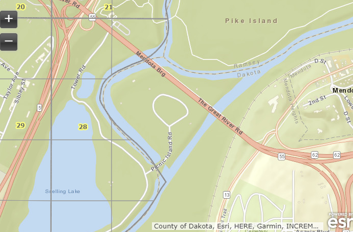
I was incorrect in my edit. Pike Island is in Ramsey County, and the little squiggle of land where the Minnesota River added a new path during a flood years ago and thus is in Dakota County, the remainder of the Fort Snelling unorganized territory is in Hennepin County. All land in Minnesota is located within a county. Check out the official Hennepin County section map at https://www.hennepin.us/residents/property/historic-and-current-section-maps. The closest I could find on the Ramsey County website is https://www.ramseycounty.us/sites/default/files/Elections%20and%20Voting/Maps/County%20maps/RamseyCountyPrecinctMap11x172018.pdf. Pike Island is indeed within the city limits of Saint Paul, see https://stpaul.maps.arcgis.com/apps/webappviewer/index.html?id=21c68099a3124881b4411859ff66c3e3. A quick map of the portion of Fort Snelling that is Dakota County is at https://www.lakesnwoods.com/temp/FtSnellingSquiggle.PNG
Look at http://www2.census.gov/geo/maps/general_ref/cousub_outline/cen2k_pgsz/mn_cosub.pdf, pages 14 and 15: Fort Snelling abuts Ramsey County, but it doesn't extend into it: the entirety of the Ramsey County area is St. Paul, and an unorganized territory can't be within a city. Meanwhile, it's not at all in Dakota County; Lilydale officials would likely deny that there's any unincorporated area where their city lies. At the same time, consider this population estimates page: Fort Snelling is listed exclusively in county 53, which is Hennepin County. Nyttend ( talk) 03:03, 25 May 2008 (UTC)
- I think there's some confusion about what this article is about. There's Fort Snelling the unorganized territory, Fort Snelling the fort and then Fort Snelling the surrounding land including the state park. The unorganized territory might only be in Hennepin county but Appraiser is correct in that the land associated with the fort stretches into all three counties. The National Historic Landmark for example is for the fort and not the territory. I think this article might need to be split into separate articles to avoid confusion. Any thoughts? ~
Eóin (
talk)
19:16, 26 May 2008 (UTC)
- Try to confine it to this article, and see if there's enough info for more than one article.
Baseball Bugs
What's up, Doc?
20:03, 26 May 2008 (UTC)
- I've been thinking that this article needs some work to explain the different areas of the fort.
Pike Island is definitely in
Ramsey County, is within
Fort Snelling State Park, and is historically significant. Picnic Island is in
Dakota County, is within
Fort Snelling State Park, and is historically significant.
[1] This discussion began due to changes to
Template:Ramsey County, Minnesota and
Template:Dakota County, Minnesota. It's hard to me to understand the argument that these islands shouldn't be represented in their respective county templates. Looking at detailed maps, they certainly are as I described and the islands are "unorganized territories." Why remove those areas from the county templates?--
Appraiser (
talk)
22:52, 26 May 2008 (UTC)
- Anything geographically within a county should certainly be in its template. I'm just saying this article shouldn't be splintered, as I doubt there's enough material to justify it.
Baseball Bugs
What's up, Doc?
02:52, 27 May 2008 (UTC)
- After looking at some maps I think I understand the issue. Fort Snelling the statistical entity is located solely in Hennepin County, however the state park and the conventional idea of Fort Snelling are in all three counties. The problem right now is this article is too focused on the statistical entity. I think the article should be split up with "Fort Snelling, Minnesota" being about the statistical entity and an article named just "Fort Snelling" about the fort and its historical significance. Thinking of Fort Snelling as a statistical entity is rather outdated, it appears the only residents are that of the VA home. I don't think the amount of material justifies a split but combing these articles is rather confusing. No one refers to Fort Snelling as a territory but rather as the fort and state park. ~
Eóin (
talk)
02:30, 28 May 2008 (UTC)
- When you watch their film at historic Fort Snelling, they treat all of it as a continuum. I don't see the point in splitting it out if they don't. Baseball Bugs What's up, Doc? 03:32, 28 May 2008 (UTC)
- After looking at some maps I think I understand the issue. Fort Snelling the statistical entity is located solely in Hennepin County, however the state park and the conventional idea of Fort Snelling are in all three counties. The problem right now is this article is too focused on the statistical entity. I think the article should be split up with "Fort Snelling, Minnesota" being about the statistical entity and an article named just "Fort Snelling" about the fort and its historical significance. Thinking of Fort Snelling as a statistical entity is rather outdated, it appears the only residents are that of the VA home. I don't think the amount of material justifies a split but combing these articles is rather confusing. No one refers to Fort Snelling as a territory but rather as the fort and state park. ~
Eóin (
talk)
02:30, 28 May 2008 (UTC)
- Anything geographically within a county should certainly be in its template. I'm just saying this article shouldn't be splintered, as I doubt there's enough material to justify it.
Baseball Bugs
What's up, Doc?
02:52, 27 May 2008 (UTC)
- I've been thinking that this article needs some work to explain the different areas of the fort.
Pike Island is definitely in
Ramsey County, is within
Fort Snelling State Park, and is historically significant. Picnic Island is in
Dakota County, is within
Fort Snelling State Park, and is historically significant.
[1] This discussion began due to changes to
Template:Ramsey County, Minnesota and
Template:Dakota County, Minnesota. It's hard to me to understand the argument that these islands shouldn't be represented in their respective county templates. Looking at detailed maps, they certainly are as I described and the islands are "unorganized territories." Why remove those areas from the county templates?--
Appraiser (
talk)
22:52, 26 May 2008 (UTC)
- Try to confine it to this article, and see if there's enough info for more than one article.
Baseball Bugs
What's up, Doc?
20:03, 26 May 2008 (UTC)
The captain's quarters at Fort Snelling, as stated on the PBS program History Detectives, is the oldest standing structure in Minnesota. Badagnani ( talk) 01:24, 8 July 2008 (UTC)
The picture used the the info box is out of date. The Flag is no longer mounted on top of the round tower but is off to the side. Could the picture be replaced with this one or one like it?
http://flickr.com/photos/mnsomero/2935051334/in/set-72157607432421214/
--
Myotus (
talk)
18:56, 4 January 2009 (UTC)
- Is it a free photo? Baseball Bugs What's up, Doc? 19:16, 4 January 2009 (UTC)
- According to the licensing listed on the page it it is creative commons licensed. I believe this tag should work. {{GFDL|cc-by-sa-3.0}}
-- Myotus ( talk) 04:48, 20 January 2009 (UTC)
- According to the licensing listed on the page it it is creative commons licensed. I believe this tag should work. {{GFDL|cc-by-sa-3.0}}
Hello fellow Wikipedians,
I have just modified 4 external links on Fort Snelling. Please take a moment to review my edit. If you have any questions, or need the bot to ignore the links, or the page altogether, please visit this simple FaQ for additional information. I made the following changes:
- Replaced archive link http://www.webcitation.org/6PWekuZo6?url=http://web.archive.org/web/20080307012554/http://wwwa.co.hennepin.mn.us/files/HCInternet/EPandT/Community%20Development/Economic%20Development/Fort%20Snelling%20Upper%20Bluff%20Reuse%20Study%20with%202006%20updates%20Part%20I.pdf with https://web.archive.org/web/20080307012554/http://wwwa.co.hennepin.mn.us/files/HCInternet/EPandT/Community%20Development/Economic%20Development/Fort%20Snelling%20Upper%20Bluff%20Reuse%20Study%20with%202006%20updates%20Part%20I.pdf on http://wwwa.co.hennepin.mn.us/files/HCInternet/EPandT/Community
- Added archive https://web.archive.org/web/20130911234518/http://factfinder2.census.gov to http://factfinder2.census.gov
- Added archive https://web.archive.org/web/20070711185102/http://www.compassairline.com/html/aboutus.htm to http://www.compassairline.com/html/aboutus.htm
- Corrected formatting/usage for http://www.mairholdings.com/vertical/Sites/{8360A74C-9CAD-4466-BA99-3DD793BFE8AC}/uploads/{5C104C7C-363F-4536-B263-2B4A2255AC77}.PDF
When you have finished reviewing my changes, you may follow the instructions on the template below to fix any issues with the URLs.
This message was posted before February 2018.
After February 2018, "External links modified" talk page sections are no longer generated or monitored by InternetArchiveBot. No special action is required regarding these talk page notices, other than
regular verification using the archive tool instructions below. Editors
have permission to delete these "External links modified" talk page sections if they want to de-clutter talk pages, but see the
RfC before doing mass systematic removals. This message is updated dynamically through the template {{
source check}} (last update: 5 June 2024).
- If you have discovered URLs which were erroneously considered dead by the bot, you can report them with this tool.
- If you found an error with any archives or the URLs themselves, you can fix them with this tool.
Cheers.— InternetArchiveBot ( Report bug) 08:23, 3 January 2017 (UTC)
Hello fellow Wikipedians,
I have just modified 4 external links on Fort Snelling. Please take a moment to review my edit. If you have any questions, or need the bot to ignore the links, or the page altogether, please visit this simple FaQ for additional information. I made the following changes:
- Added archive https://web.archive.org/web/20080313124510/http://tps.cr.nps.gov/nhl/detail.cfm?ResourceId=278&ResourceType=District to http://tps.cr.nps.gov/nhl/detail.cfm?ResourceId=278&ResourceType=District
- Corrected formatting/usage for http://factfinder2.census.gov/
- Added archive https://web.archive.org/web/20120318204429/http://www.mycreditunionnewsletter.com/wings_financial/money_matters/spring11/article2.html to http://www.mycreditunionnewsletter.com/wings_financial/money_matters/spring11/article2.html
- Added archive https://web.archive.org/web/20080313124510/http://tps.cr.nps.gov/nhl/detail.cfm?ResourceId=278&ResourceType=District to http://tps.cr.nps.gov/nhl/detail.cfm?ResourceId=278&ResourceType=District
When you have finished reviewing my changes, you may follow the instructions on the template below to fix any issues with the URLs.
This message was posted before February 2018.
After February 2018, "External links modified" talk page sections are no longer generated or monitored by InternetArchiveBot. No special action is required regarding these talk page notices, other than
regular verification using the archive tool instructions below. Editors
have permission to delete these "External links modified" talk page sections if they want to de-clutter talk pages, but see the
RfC before doing mass systematic removals. This message is updated dynamically through the template {{
source check}} (last update: 5 June 2024).
- If you have discovered URLs which were erroneously considered dead by the bot, you can report them with this tool.
- If you found an error with any archives or the URLs themselves, you can fix them with this tool.
Cheers.— InternetArchiveBot ( Report bug) 13:40, 4 October 2017 (UTC)
I'm rather confused about dates and terminology.
If the fort was decommissioned in 1946, how could it still serve to be the headquarters for a brigade up to 1994?
Does the brigade being a "reserve" one make a difference.
I thought that once something was decommissioned, it was no longer used and no longer "officially" part of the military/service; even in "reserve" capacity.
If I'm missing something, I think that other non military/service people will also be confused.
Can this be clarified?
Or am I still missing something? 2600:8800:785:1300:C23F:D5FF:FEC4:D51D ( talk) 06:06, 23 October 2018 (UTC)
I'm also confused, it says at one point "From construction in 1820 to closure in 1858"... closed in 1858?? what about all the Dakota camp activity during the civil war? ---Skates61 — Preceding unsigned comment added by 76.29.89.21 ( talk) 21:19, 28 October 2021 (UTC)
- When Minnesota became a state, the army sold it to Franklin Steele in 1858 for $90,000. When the American Civil War broke out the Government commandeered the fort for the War Department as an induction station. Franklin Steele made a very tidy sum with the U.S. government buying it back as he almost went bankrupt with his land speculation. The War Department decommissioned Fort Snelling a second time on 14 October 1946. Myotus ( talk) 21:33, 28 October 2021 (UTC)
The article reflist shows the attached link as a "dead link" when it works fine here. Cans someone explain please. [2] Thank you. Mcb133aco ( talk) 01:18, 1 October 2020 (UTC)mcb133aco Mcb133aco ( talk) 01:18, 1 October 2020 (UTC)
The word B'dote does not appear in the historic record nor does any reference to a B'dote Homeland (recently added to the lead). Mindota is the word used in the Historic record. It is the English version of M'dota. That spelling is also not in the Fort record. As far as the Fort sitting in the Bdote homeland the entire State of Minnesota sits of former first nations land. The statement seems intended to vilify the subject and does not add real content. The word B'dote seems to first appear in any fort record when the Minnesota Historical Society decided to add it to the Fort Snelling Park signs in 2017. MHS has since injected it into the fort's history replacing the word Mindota. I believe that the MHS is a problematic source for citing B'dote or B'dote homeland. I have been informed by a native speaker that B'dote and M'dota are dialect variations with the same meaning.
Fort Snelling and B'dote/Mindota share the same geographic location, but really are two separate subjects. As topics, Fort Snelling has overwhelmed the B'dote/Mindota story. Whereas, Bdote/Mindota are a paragraph of the Fort Snelling history. Since this is an article on the Fort, it should reflect Fort history and use the word Mindota as it was used at the fort for 198 years. Wikipedia is not the appropriate place for revisionist history without proper footnotes or disambiguation. Mcb133aco ( talk) 17:07, 12 November 2020 (UTC)mcb133aco Mcb133aco ( talk) 17:07, 12 November 2020 (UTC)
- The Dakota language was not a written language at the time of those historical documents, therefore it seems like you're cherry-picking reasons why those historical documents should override modern day Dakota people's common name for the place. Dakota people were put in a concentration camp at Bdote at Fort Snelling before being exiled from the state, therefore it is part of Fort Snelling history. It was also the chosen place by Dakota people and Europeans as a meeting place to sign the treaty that allowed Fort Snelling to be built. There is nothing controversial about dialect differences of the same word other than you don't want to accept Dakota sources such as reliable with Bdote being the common name. Or you haven't bothered to include them in your research. There are numerous published books that refer to it as Bdote. Your comment even fails to mention Dakota people by name, which is interesting. It appears you somehow want to erase and ignore actual Dakota significance to the history of the land that Fort Snelling exists upon. oncamera (talk page) 18:01, 12 November 2020 (UTC)
- It seems clear that you do not have a neutral POV. The article is about the History of the fort not the current spelling or language use of the Dakota. There is no cherry picking going on it is stating the historical record that you seem to object to for being written by non-natives. The obliteration of Mindota/M'dota as it was historically used at Fort Snelling is historical censorship. It seems very clear that there should be an annotation or explanation for the use of B'dote in place of Mindota.
- Simply stating there are numerous books now that use the word B'dote without stating their date of publication or if they are citing the MHS is academically weak.
- As to naming the Dakota, to what end? The topic is the word B'dote/Mindota.
- Lastly, your comments seem to want to paint me as a bigot. I would point that whoever wrote the Dakota narrative to to the Fort Snelling story left a few things out. I am the one that wrote of the deaths enroute to Crow Creek, the deaths at Crow Creek, the degregation the woman suffered with their men gone. I am the one that posted one of the women at Fort Snelling was raped. That there was no sanitation. That the camp was overrun by measles and cholera. This is an encyclopedia and you do not have hit the reader over the head with the word Dakota multiple times. It is also based upon a neutral POV that you seem to need more of.
Mcb133aco (
talk) 15:03, 13 November 2020 (UTC) mcb133aco
Mcb133aco (
talk)
15:03, 13 November 2020 (UTC)
- Back on topic, the Minnesota Historical Society is a reliable source and they consistently use bdote in their articles about this topic. Just because you disagree with MHS use of the modern commonname doesn't mean it's somehow an unreliable source. You can always add a footnote noting the outdated use of "Mendota" or whatever you say it's written as in "historical documents", but Bdote is the WP:Common Name as used by Dakota people and books/articles published by MHS and thus, Wikipedia standards say to use that over alternative spellings. oncamera (talk page) 17:40, 13 November 2020 (UTC)
- As an aside to this conversation, I think there should also be a standalone article about B'bote. It is an important subtext to Fort Snelling, but it's "bigger" than just Fort Snelling, if that makes sense. Is there any interest in collaboration on that? Thoughts? Respectfully,
Minnemeeples (
talk)
18:37, 13 November 2020 (UTC)
- I could help, but the article should be called
Bdote and not "B'bote". Besides the misspelling, there is no apostrophe in the common name.
oncamera
(talk page)
20:00, 13 November 2020 (UTC)
- Hi, I mentioned below I'm working on a draft for Bdote. Please see that comment if you're interested! Pingnova ( talk) 00:26, 21 August 2023 (UTC)
- Hello, I am drafting an article on Bdote. If you or other editors of this page wish to contribute information, sources, or guidance on article structure, please feel free to. The grammar, spelling, and style are not fantastic at this point since I'm focusing first on gathering information and citations, so I am not looking for a thorough SPAG edit. Thanks for bringing this up on this article!
- The draft: Draft:Bdóte Pingnova ( talk) 00:25, 21 August 2023 (UTC)
- I could help, but the article should be called
Bdote and not "B'bote". Besides the misspelling, there is no apostrophe in the common name.
oncamera
(talk page)
20:00, 13 November 2020 (UTC)
- As an aside to this conversation, I think there should also be a standalone article about B'bote. It is an important subtext to Fort Snelling, but it's "bigger" than just Fort Snelling, if that makes sense. Is there any interest in collaboration on that? Thoughts? Respectfully,
Minnemeeples (
talk)
18:37, 13 November 2020 (UTC)
- As I'm coming into this conversation late, I don't know how helpful this would be, but the Dakota Language has gone through several sound changes in the past century, one of them, for example, is what was watpa meaning "river" is today said as wakpa. Another example and to the point in this conversation is that what was Mdewakaŋtuŋ and Mdote (and Midewakaŋtuŋ and Mindote respectively before that) have denasaled and today are now Bdewakaŋtuŋ and Bdote. The apostrophe between the first two consonants is an English convention but it is not a Dakota convention, as an apostrophe is used only to indicate ejectives, which that particular syllable does not contain. Consequently, if these pronunciation differences could be linked to certain periods of Dakota history, then the appropriate Dakota word form for that period should be used, and it will also highlight that Dakota is a living language, and not some fossilised language recorded by the settler society. CJLippert ( talk) 14:10, 17 November 2020 (UTC)
There's been a lot of confusion about this: Fort Snelling is an unorganized territory of Hennepin County, not with respect to the United States of America. Minnesota was not admitted as a state with any exceptions. You'll find it along with the many other unorganized territories in Minnesota, not in territories of the United States. You can see this on official state maps: [3][ [4] The issues of land cessions and treaties apply to a much larger area (all of Minneapolis?) than the current territory within Hennepin County. — innotata 17:48, 17 December 2022 (UTC)
The article states, "It ceded 155,320 acres of land in the area (400 km2)." But 155,320 acres is not 400 square kilometers, and the book I have here in front of me states, "They ceded about 100,000 acres, according to Pike’s estimate, valued by him at $200,000." Awhit003 ( talk) 01:20, 14 November 2023 (UTC)
- It's the same book referenced by the article. Awhit003 ( talk) 01:20, 14 November 2023 (UTC)
- C-Class Minnesota articles
- High-importance Minnesota articles
- C-Class National Register of Historic Places articles
- High-importance National Register of Historic Places articles
- C-Class National Register of Historic Places articles of High-importance
- C-Class military history articles
- C-Class fortifications articles
- Fortifications task force articles
- C-Class North American military history articles
- North American military history task force articles
- C-Class United States military history articles
- United States military history task force articles
|
| This article is rated C-class on Wikipedia's
content assessment scale. It is of interest to the following WikiProjects: | ||||||||||||||||||||||||||||||||||||||||||||||||||||||
| |||||||||||||||||||||||||||||||||||||||||||||||||||||||
Based upon MNHS information displayed during a personal mid-July 2006 site visit:
The original installation was begun in 1820 by LCOL Henry Leavenworth. [1] Construction of Fort Saint Anthony continued until 1825 when it received its current name upon completion in honor of Colonel Josiah Snelling. He commanded the regiment that finished building it, and oversaw most of its construction.
Mapping the Frontier Military Road
Fort Snelling was the northern-most outpost protecting commercial fur trading interests along the pre- 1830's demarcation line of the U.S. Government's treaty-based " Indian Territory" ... The 1823 land and watershed survey expeditions supported by Fort St. Anthony helped guide future developments in the Wisconsin Territory.
- Giacomo Beltrami - Upper Mississippi River Basin mapping expedition in 1823
- Fort Scott National Historic Site - Supplied by Fort Leavenworth wagon trains
- Stephen H. Long with the Permanent Indian Frontier Army's Topographical Engineers
- Patrolling the Indian Frontier
The census says there are 0.09. Kusma (討論) 12:24, 2 November 2006 (UTC)
"Snelling was considered to be a reasonable commander—when he was sober. He was susceptible to becoming angry when ill from chronic dysentery, and he left the installation in September 1827 when recalled to Washington. He died a year later from complications due to dysentery and a "brain fever"."
I don't need to look at the wikipedia standards to know that this is not the correct style to be using. And while it is funny, and I did laugh out loud, I don't think it's what should be here... —The preceding unsigned comment was added by 131.247.152.4 ( talk) 03:43, 11 May 2007 (UTC).
Article reassessed and graded as start class. -- dashiellx ( talk) 18:26, 1 May 2008 (UTC)
I was incorrect in my edit. Pike Island is in Ramsey County, and the little squiggle of land where the Minnesota River added a new path during a flood years ago and thus is in Dakota County, the remainder of the Fort Snelling unorganized territory is in Hennepin County. All land in Minnesota is located within a county. Check out the official Hennepin County section map at https://www.hennepin.us/residents/property/historic-and-current-section-maps. The closest I could find on the Ramsey County website is https://www.ramseycounty.us/sites/default/files/Elections%20and%20Voting/Maps/County%20maps/RamseyCountyPrecinctMap11x172018.pdf. Pike Island is indeed within the city limits of Saint Paul, see https://stpaul.maps.arcgis.com/apps/webappviewer/index.html?id=21c68099a3124881b4411859ff66c3e3. A quick map of the portion of Fort Snelling that is Dakota County is at https://www.lakesnwoods.com/temp/FtSnellingSquiggle.PNG
Look at http://www2.census.gov/geo/maps/general_ref/cousub_outline/cen2k_pgsz/mn_cosub.pdf, pages 14 and 15: Fort Snelling abuts Ramsey County, but it doesn't extend into it: the entirety of the Ramsey County area is St. Paul, and an unorganized territory can't be within a city. Meanwhile, it's not at all in Dakota County; Lilydale officials would likely deny that there's any unincorporated area where their city lies. At the same time, consider this population estimates page: Fort Snelling is listed exclusively in county 53, which is Hennepin County. Nyttend ( talk) 03:03, 25 May 2008 (UTC)
- I think there's some confusion about what this article is about. There's Fort Snelling the unorganized territory, Fort Snelling the fort and then Fort Snelling the surrounding land including the state park. The unorganized territory might only be in Hennepin county but Appraiser is correct in that the land associated with the fort stretches into all three counties. The National Historic Landmark for example is for the fort and not the territory. I think this article might need to be split into separate articles to avoid confusion. Any thoughts? ~
Eóin (
talk)
19:16, 26 May 2008 (UTC)
- Try to confine it to this article, and see if there's enough info for more than one article.
Baseball Bugs
What's up, Doc?
20:03, 26 May 2008 (UTC)
- I've been thinking that this article needs some work to explain the different areas of the fort.
Pike Island is definitely in
Ramsey County, is within
Fort Snelling State Park, and is historically significant. Picnic Island is in
Dakota County, is within
Fort Snelling State Park, and is historically significant.
[1] This discussion began due to changes to
Template:Ramsey County, Minnesota and
Template:Dakota County, Minnesota. It's hard to me to understand the argument that these islands shouldn't be represented in their respective county templates. Looking at detailed maps, they certainly are as I described and the islands are "unorganized territories." Why remove those areas from the county templates?--
Appraiser (
talk)
22:52, 26 May 2008 (UTC)
- Anything geographically within a county should certainly be in its template. I'm just saying this article shouldn't be splintered, as I doubt there's enough material to justify it.
Baseball Bugs
What's up, Doc?
02:52, 27 May 2008 (UTC)
- After looking at some maps I think I understand the issue. Fort Snelling the statistical entity is located solely in Hennepin County, however the state park and the conventional idea of Fort Snelling are in all three counties. The problem right now is this article is too focused on the statistical entity. I think the article should be split up with "Fort Snelling, Minnesota" being about the statistical entity and an article named just "Fort Snelling" about the fort and its historical significance. Thinking of Fort Snelling as a statistical entity is rather outdated, it appears the only residents are that of the VA home. I don't think the amount of material justifies a split but combing these articles is rather confusing. No one refers to Fort Snelling as a territory but rather as the fort and state park. ~
Eóin (
talk)
02:30, 28 May 2008 (UTC)
- When you watch their film at historic Fort Snelling, they treat all of it as a continuum. I don't see the point in splitting it out if they don't. Baseball Bugs What's up, Doc? 03:32, 28 May 2008 (UTC)
- After looking at some maps I think I understand the issue. Fort Snelling the statistical entity is located solely in Hennepin County, however the state park and the conventional idea of Fort Snelling are in all three counties. The problem right now is this article is too focused on the statistical entity. I think the article should be split up with "Fort Snelling, Minnesota" being about the statistical entity and an article named just "Fort Snelling" about the fort and its historical significance. Thinking of Fort Snelling as a statistical entity is rather outdated, it appears the only residents are that of the VA home. I don't think the amount of material justifies a split but combing these articles is rather confusing. No one refers to Fort Snelling as a territory but rather as the fort and state park. ~
Eóin (
talk)
02:30, 28 May 2008 (UTC)
- Anything geographically within a county should certainly be in its template. I'm just saying this article shouldn't be splintered, as I doubt there's enough material to justify it.
Baseball Bugs
What's up, Doc?
02:52, 27 May 2008 (UTC)
- I've been thinking that this article needs some work to explain the different areas of the fort.
Pike Island is definitely in
Ramsey County, is within
Fort Snelling State Park, and is historically significant. Picnic Island is in
Dakota County, is within
Fort Snelling State Park, and is historically significant.
[1] This discussion began due to changes to
Template:Ramsey County, Minnesota and
Template:Dakota County, Minnesota. It's hard to me to understand the argument that these islands shouldn't be represented in their respective county templates. Looking at detailed maps, they certainly are as I described and the islands are "unorganized territories." Why remove those areas from the county templates?--
Appraiser (
talk)
22:52, 26 May 2008 (UTC)
- Try to confine it to this article, and see if there's enough info for more than one article.
Baseball Bugs
What's up, Doc?
20:03, 26 May 2008 (UTC)
The captain's quarters at Fort Snelling, as stated on the PBS program History Detectives, is the oldest standing structure in Minnesota. Badagnani ( talk) 01:24, 8 July 2008 (UTC)
The picture used the the info box is out of date. The Flag is no longer mounted on top of the round tower but is off to the side. Could the picture be replaced with this one or one like it?
http://flickr.com/photos/mnsomero/2935051334/in/set-72157607432421214/
--
Myotus (
talk)
18:56, 4 January 2009 (UTC)
- Is it a free photo? Baseball Bugs What's up, Doc? 19:16, 4 January 2009 (UTC)
- According to the licensing listed on the page it it is creative commons licensed. I believe this tag should work. {{GFDL|cc-by-sa-3.0}}
-- Myotus ( talk) 04:48, 20 January 2009 (UTC)
- According to the licensing listed on the page it it is creative commons licensed. I believe this tag should work. {{GFDL|cc-by-sa-3.0}}
Hello fellow Wikipedians,
I have just modified 4 external links on Fort Snelling. Please take a moment to review my edit. If you have any questions, or need the bot to ignore the links, or the page altogether, please visit this simple FaQ for additional information. I made the following changes:
- Replaced archive link http://www.webcitation.org/6PWekuZo6?url=http://web.archive.org/web/20080307012554/http://wwwa.co.hennepin.mn.us/files/HCInternet/EPandT/Community%20Development/Economic%20Development/Fort%20Snelling%20Upper%20Bluff%20Reuse%20Study%20with%202006%20updates%20Part%20I.pdf with https://web.archive.org/web/20080307012554/http://wwwa.co.hennepin.mn.us/files/HCInternet/EPandT/Community%20Development/Economic%20Development/Fort%20Snelling%20Upper%20Bluff%20Reuse%20Study%20with%202006%20updates%20Part%20I.pdf on http://wwwa.co.hennepin.mn.us/files/HCInternet/EPandT/Community
- Added archive https://web.archive.org/web/20130911234518/http://factfinder2.census.gov to http://factfinder2.census.gov
- Added archive https://web.archive.org/web/20070711185102/http://www.compassairline.com/html/aboutus.htm to http://www.compassairline.com/html/aboutus.htm
- Corrected formatting/usage for http://www.mairholdings.com/vertical/Sites/{8360A74C-9CAD-4466-BA99-3DD793BFE8AC}/uploads/{5C104C7C-363F-4536-B263-2B4A2255AC77}.PDF
When you have finished reviewing my changes, you may follow the instructions on the template below to fix any issues with the URLs.
This message was posted before February 2018.
After February 2018, "External links modified" talk page sections are no longer generated or monitored by InternetArchiveBot. No special action is required regarding these talk page notices, other than
regular verification using the archive tool instructions below. Editors
have permission to delete these "External links modified" talk page sections if they want to de-clutter talk pages, but see the
RfC before doing mass systematic removals. This message is updated dynamically through the template {{
source check}} (last update: 5 June 2024).
- If you have discovered URLs which were erroneously considered dead by the bot, you can report them with this tool.
- If you found an error with any archives or the URLs themselves, you can fix them with this tool.
Cheers.— InternetArchiveBot ( Report bug) 08:23, 3 January 2017 (UTC)
Hello fellow Wikipedians,
I have just modified 4 external links on Fort Snelling. Please take a moment to review my edit. If you have any questions, or need the bot to ignore the links, or the page altogether, please visit this simple FaQ for additional information. I made the following changes:
- Added archive https://web.archive.org/web/20080313124510/http://tps.cr.nps.gov/nhl/detail.cfm?ResourceId=278&ResourceType=District to http://tps.cr.nps.gov/nhl/detail.cfm?ResourceId=278&ResourceType=District
- Corrected formatting/usage for http://factfinder2.census.gov/
- Added archive https://web.archive.org/web/20120318204429/http://www.mycreditunionnewsletter.com/wings_financial/money_matters/spring11/article2.html to http://www.mycreditunionnewsletter.com/wings_financial/money_matters/spring11/article2.html
- Added archive https://web.archive.org/web/20080313124510/http://tps.cr.nps.gov/nhl/detail.cfm?ResourceId=278&ResourceType=District to http://tps.cr.nps.gov/nhl/detail.cfm?ResourceId=278&ResourceType=District
When you have finished reviewing my changes, you may follow the instructions on the template below to fix any issues with the URLs.
This message was posted before February 2018.
After February 2018, "External links modified" talk page sections are no longer generated or monitored by InternetArchiveBot. No special action is required regarding these talk page notices, other than
regular verification using the archive tool instructions below. Editors
have permission to delete these "External links modified" talk page sections if they want to de-clutter talk pages, but see the
RfC before doing mass systematic removals. This message is updated dynamically through the template {{
source check}} (last update: 5 June 2024).
- If you have discovered URLs which were erroneously considered dead by the bot, you can report them with this tool.
- If you found an error with any archives or the URLs themselves, you can fix them with this tool.
Cheers.— InternetArchiveBot ( Report bug) 13:40, 4 October 2017 (UTC)
I'm rather confused about dates and terminology.
If the fort was decommissioned in 1946, how could it still serve to be the headquarters for a brigade up to 1994?
Does the brigade being a "reserve" one make a difference.
I thought that once something was decommissioned, it was no longer used and no longer "officially" part of the military/service; even in "reserve" capacity.
If I'm missing something, I think that other non military/service people will also be confused.
Can this be clarified?
Or am I still missing something? 2600:8800:785:1300:C23F:D5FF:FEC4:D51D ( talk) 06:06, 23 October 2018 (UTC)
I'm also confused, it says at one point "From construction in 1820 to closure in 1858"... closed in 1858?? what about all the Dakota camp activity during the civil war? ---Skates61 — Preceding unsigned comment added by 76.29.89.21 ( talk) 21:19, 28 October 2021 (UTC)
- When Minnesota became a state, the army sold it to Franklin Steele in 1858 for $90,000. When the American Civil War broke out the Government commandeered the fort for the War Department as an induction station. Franklin Steele made a very tidy sum with the U.S. government buying it back as he almost went bankrupt with his land speculation. The War Department decommissioned Fort Snelling a second time on 14 October 1946. Myotus ( talk) 21:33, 28 October 2021 (UTC)
The article reflist shows the attached link as a "dead link" when it works fine here. Cans someone explain please. [2] Thank you. Mcb133aco ( talk) 01:18, 1 October 2020 (UTC)mcb133aco Mcb133aco ( talk) 01:18, 1 October 2020 (UTC)
The word B'dote does not appear in the historic record nor does any reference to a B'dote Homeland (recently added to the lead). Mindota is the word used in the Historic record. It is the English version of M'dota. That spelling is also not in the Fort record. As far as the Fort sitting in the Bdote homeland the entire State of Minnesota sits of former first nations land. The statement seems intended to vilify the subject and does not add real content. The word B'dote seems to first appear in any fort record when the Minnesota Historical Society decided to add it to the Fort Snelling Park signs in 2017. MHS has since injected it into the fort's history replacing the word Mindota. I believe that the MHS is a problematic source for citing B'dote or B'dote homeland. I have been informed by a native speaker that B'dote and M'dota are dialect variations with the same meaning.
Fort Snelling and B'dote/Mindota share the same geographic location, but really are two separate subjects. As topics, Fort Snelling has overwhelmed the B'dote/Mindota story. Whereas, Bdote/Mindota are a paragraph of the Fort Snelling history. Since this is an article on the Fort, it should reflect Fort history and use the word Mindota as it was used at the fort for 198 years. Wikipedia is not the appropriate place for revisionist history without proper footnotes or disambiguation. Mcb133aco ( talk) 17:07, 12 November 2020 (UTC)mcb133aco Mcb133aco ( talk) 17:07, 12 November 2020 (UTC)
- The Dakota language was not a written language at the time of those historical documents, therefore it seems like you're cherry-picking reasons why those historical documents should override modern day Dakota people's common name for the place. Dakota people were put in a concentration camp at Bdote at Fort Snelling before being exiled from the state, therefore it is part of Fort Snelling history. It was also the chosen place by Dakota people and Europeans as a meeting place to sign the treaty that allowed Fort Snelling to be built. There is nothing controversial about dialect differences of the same word other than you don't want to accept Dakota sources such as reliable with Bdote being the common name. Or you haven't bothered to include them in your research. There are numerous published books that refer to it as Bdote. Your comment even fails to mention Dakota people by name, which is interesting. It appears you somehow want to erase and ignore actual Dakota significance to the history of the land that Fort Snelling exists upon. oncamera (talk page) 18:01, 12 November 2020 (UTC)
- It seems clear that you do not have a neutral POV. The article is about the History of the fort not the current spelling or language use of the Dakota. There is no cherry picking going on it is stating the historical record that you seem to object to for being written by non-natives. The obliteration of Mindota/M'dota as it was historically used at Fort Snelling is historical censorship. It seems very clear that there should be an annotation or explanation for the use of B'dote in place of Mindota.
- Simply stating there are numerous books now that use the word B'dote without stating their date of publication or if they are citing the MHS is academically weak.
- As to naming the Dakota, to what end? The topic is the word B'dote/Mindota.
- Lastly, your comments seem to want to paint me as a bigot. I would point that whoever wrote the Dakota narrative to to the Fort Snelling story left a few things out. I am the one that wrote of the deaths enroute to Crow Creek, the deaths at Crow Creek, the degregation the woman suffered with their men gone. I am the one that posted one of the women at Fort Snelling was raped. That there was no sanitation. That the camp was overrun by measles and cholera. This is an encyclopedia and you do not have hit the reader over the head with the word Dakota multiple times. It is also based upon a neutral POV that you seem to need more of.
Mcb133aco (
talk) 15:03, 13 November 2020 (UTC) mcb133aco
Mcb133aco (
talk)
15:03, 13 November 2020 (UTC)
- Back on topic, the Minnesota Historical Society is a reliable source and they consistently use bdote in their articles about this topic. Just because you disagree with MHS use of the modern commonname doesn't mean it's somehow an unreliable source. You can always add a footnote noting the outdated use of "Mendota" or whatever you say it's written as in "historical documents", but Bdote is the WP:Common Name as used by Dakota people and books/articles published by MHS and thus, Wikipedia standards say to use that over alternative spellings. oncamera (talk page) 17:40, 13 November 2020 (UTC)
- As an aside to this conversation, I think there should also be a standalone article about B'bote. It is an important subtext to Fort Snelling, but it's "bigger" than just Fort Snelling, if that makes sense. Is there any interest in collaboration on that? Thoughts? Respectfully,
Minnemeeples (
talk)
18:37, 13 November 2020 (UTC)
- I could help, but the article should be called
Bdote and not "B'bote". Besides the misspelling, there is no apostrophe in the common name.
oncamera
(talk page)
20:00, 13 November 2020 (UTC)
- Hi, I mentioned below I'm working on a draft for Bdote. Please see that comment if you're interested! Pingnova ( talk) 00:26, 21 August 2023 (UTC)
- Hello, I am drafting an article on Bdote. If you or other editors of this page wish to contribute information, sources, or guidance on article structure, please feel free to. The grammar, spelling, and style are not fantastic at this point since I'm focusing first on gathering information and citations, so I am not looking for a thorough SPAG edit. Thanks for bringing this up on this article!
- The draft: Draft:Bdóte Pingnova ( talk) 00:25, 21 August 2023 (UTC)
- I could help, but the article should be called
Bdote and not "B'bote". Besides the misspelling, there is no apostrophe in the common name.
oncamera
(talk page)
20:00, 13 November 2020 (UTC)
- As an aside to this conversation, I think there should also be a standalone article about B'bote. It is an important subtext to Fort Snelling, but it's "bigger" than just Fort Snelling, if that makes sense. Is there any interest in collaboration on that? Thoughts? Respectfully,
Minnemeeples (
talk)
18:37, 13 November 2020 (UTC)
- As I'm coming into this conversation late, I don't know how helpful this would be, but the Dakota Language has gone through several sound changes in the past century, one of them, for example, is what was watpa meaning "river" is today said as wakpa. Another example and to the point in this conversation is that what was Mdewakaŋtuŋ and Mdote (and Midewakaŋtuŋ and Mindote respectively before that) have denasaled and today are now Bdewakaŋtuŋ and Bdote. The apostrophe between the first two consonants is an English convention but it is not a Dakota convention, as an apostrophe is used only to indicate ejectives, which that particular syllable does not contain. Consequently, if these pronunciation differences could be linked to certain periods of Dakota history, then the appropriate Dakota word form for that period should be used, and it will also highlight that Dakota is a living language, and not some fossilised language recorded by the settler society. CJLippert ( talk) 14:10, 17 November 2020 (UTC)
There's been a lot of confusion about this: Fort Snelling is an unorganized territory of Hennepin County, not with respect to the United States of America. Minnesota was not admitted as a state with any exceptions. You'll find it along with the many other unorganized territories in Minnesota, not in territories of the United States. You can see this on official state maps: [3][ [4] The issues of land cessions and treaties apply to a much larger area (all of Minneapolis?) than the current territory within Hennepin County. — innotata 17:48, 17 December 2022 (UTC)
The article states, "It ceded 155,320 acres of land in the area (400 km2)." But 155,320 acres is not 400 square kilometers, and the book I have here in front of me states, "They ceded about 100,000 acres, according to Pike’s estimate, valued by him at $200,000." Awhit003 ( talk) 01:20, 14 November 2023 (UTC)
- It's the same book referenced by the article. Awhit003 ( talk) 01:20, 14 November 2023 (UTC)
- C-Class Minnesota articles
- High-importance Minnesota articles
- C-Class National Register of Historic Places articles
- High-importance National Register of Historic Places articles
- C-Class National Register of Historic Places articles of High-importance
- C-Class military history articles
- C-Class fortifications articles
- Fortifications task force articles
- C-Class North American military history articles
- North American military history task force articles
- C-Class United States military history articles
- United States military history task force articles