This article is within the scope of WikiProject Weather, which collaborates on weather and related subjects on Wikipedia. To participate, help improve this article or visit the
project page for details.
More info. Perhaps you could mention storms where Dvorak constraints were broken. That occurred during Elida during the 2002 EPAC season. Also, what are the highest ones? IIRC, Angela in 1995 got up to an 8, along with 2 other storms.
Hurricanehink (
talk)
03:42, 22 May 2006 (UTC)reply
I think the Dvorak constraints are not very useful. They simply, (if my understanding is correct) give a guideline of how fast a typical storm will stregthen. Is based on statistical data, does not consider the environment of the hurricane. Also 8.0 is the highest possible Dvorak number.
TimL03:18, 26 May 2006 (UTC)reply
Part of the text seems to be cut off at the end. Also, I've seen a chart somewhere with a column for the minimum pressure estimates for pacific basin storms as they have a lower pressure in general. I can't remember if it was on the NHC site or in Dvorak's paper itself. I have it saved somewhere on my computer if you decide to add it and can't locate the numbers.
Dr Denim03:46, 22 May 2006 (UTC)reply
oh and I just remembered something else worth adding is the usage of the Dvorak technique in forecasting intensity changes
Dr Denim03:57, 22 May 2006 (UTC)reply
Further research indicates to me that the Dvorak technique is not skilled at forecasting intensity. It is not mentioned by the NHC in their year-end accuracy report, so I don't think it is worth a mention here.
TimL03:18, 26 May 2006 (UTC)reply
I think it might still be worth mentioning as it is part of the technique even if it isn't used often and I'd assume it is just as reliable as the persistance model for intensity change...can't remember what that was called...
Dr Denim12:25, 26 May 2006 (UTC)reply
The important thing to remember about the Dvorak technique is that it isn't used as a model to numerically predict intensities, but rather just a "the intensity is increasing/decreasing/steady state" kind of thing, which can just as easily be determined by simply looking at a satellite image. It's more of a predictor of what trend is currently underway in the cyclone's structure/intensity. And since its forecasting role is so limited, and it is not a model of any sort, it isn't mentioned in the NHC's verification reports.
WindRunner18:56, 27 May 2006 (UTC)reply
I remember Elida, she was crazy. Discussion of breaking Dvorak:
[1][2][3]:
ELIDA HAS BROKEN ALL THE DVORAK RULES. IT HAS INTENSIFIED RAPIDLY
SINCE YESTERDAY AND DATA T-NUMBERS ARE UP TO 6.0 PLUS WITH OBJECTIVE
NUMBERS REACHING 6.5 DURING THE PAST HOUR OR SO.
Something else that might be handy is an example satelite image...and for that matter if we could somehow upload the drawings(or replications of them) of the satelite images for different CI numbers that apear in his essay on the technique that'd be really helpful...if I could find a way to make the images on my computer or get my scanned drawings to look smoother I'd be willing to make them...I have them sketched somewhere...anywho
Dr Denim11:43, 23 May 2006 (UTC)reply
Yes, I thought that might be a compelling addition to the article. I have not seen the essay, nor do I know how to access it, but an idea I had was to grab public domain satellite image for storms of a certain CI and show them together. There could be a set of images for several 3.0 CI storms and another set for several 4.0 CI storms.
TimL19:25, 23 May 2006 (UTC)reply
well...if you live near a university that has a meteorology program then they might have one...if I get the chance to stop by school sometime this summer I'll have to try and photocopy the essay so I can have a copy of it on hand...I've looked around the noaa websites for it but haven't had any luck...mayhap I'll look around on google or something...anywho...those reference images would be really helpful in explaining the technique...especially to someone who isn't familiar with the terminology. I'll look around and see if I can't find a copy of the essay online somewhere
Dr Denim20:06, 23 May 2006 (UTC)reply
here's a link to the abstract so that the citation information can be added by someone at least...still looking for an online version though
ah here's an image of one of the several charts in the paper...the website's messed up on this computer(probably in an asian charater set) so I can't tell if it's public domain or not (although considering the fact that I can't find the essay itself it's probably not public domain)...anywho
Okay...so I uploaded the notes I took when I read the essay onto my deviant art account...although I never got around to finishing the essay but I got a good chunk of it done...
Could we have a wider range of images showing TCs at various CI's. 2.5, 3.0 and 3.5 isn't much of a range. It should give an impression of how it varies from 2.0 up to 8.0. And ideally it shouldn't be solely Atlantic storms.--
Nilfanion (
talk)
09:25, 12 June 2006 (UTC)reply
That is quite reasonable. Other basins are doable as long as they have readily available advisory/discussion archives which mention T-numbers. Since the other basins rely soley on the Dvorak technique(i.e no reconaissance) I would be suprised if they didn't.
Images could also be broken down into the various pattern types, though this would require some skill with the dvorak technique. There is a presenation I should throw in the external links which has drawings of the various pattern types at different intensities.
TimL22:52, 12 June 2006 (UTC)reply
I removed all references to AFWA (KGWC) providing Dvorak fixes on tropical cyclones. I work there and know they no longer provide fixes. This was mentioned in the 2007 National Hurricane Operations Plan. Also, in the 2007 Office of the Federal Coordinator for Meteorology Action Items list, Point #12, it said the following:
"Due to recent personnel and funding cuts, the Air Force Weather Agency (AFWA) can no longer dedicate the resources needed to sustain tropical cyclone satellite imagery surveillance and analysis support to the National Hurricane Operations Plan. This cessation of support requires changes in the NHOP to reflect the AFWA termination but continuance of support on request, resources permitting, by the 17th Operational Weather Squadron Meteorological Satellite Operations (SATOPS) Flight (17 OWS/WXJ), Joint Typhoon Warning Center, Pearl Harbor, HI to the Central Pacific Hurricane Center.)
Lead: must mention the more commonly-use "Level 1 to 5" hurricane intensity scale: compare and contrast with Dvorak (because readers, at least in US, will have heard the 1-to-5 frequently in the news reports)
The table below compared the T numbers used in the Dvorak scale to hurricane categories. I don't see why we'd need to add this sort of information into the lead. The lead is meant to be a broad summary of the article below.
Thegreatdr (
talk)
21:06, 21 November 2012 (UTC)reply
Lead: Must explain if hurricanes are included or not
I believe I have now addressed this. Remember that we can't introduce POV into the article, so I've tried to use more global terms. Tropical cyclones include TD, TS, and HU/TY/Intense TC intensities explicitly.
Thegreatdr (
talk)
21:09, 21 November 2012 (UTC)reply
What is the POV issue? I thought Hurricane simply means a cyclone in the Atlantic, no? Many readers will know what a hurricane is, but will not be familiar with cyclone. --
Noleander (
talk)
18:26, 23 November 2012 (UTC)reply
Footnote in lead: Why is footnote #1 in the lead section? footnotes are optional there, and all material in lead is supposed to also be in the body (where the footnote should normally be placed).
If you want me to remove it, I can. Some people who review GA articles demand it, even if it is optional, as you say. Other references further down the article cover this.
Thegreatdr (
talk)
21:12, 21 November 2012 (UTC)reply
No need to measure wind speed (fly aircraft into?) - I don't see a comparison of Dvorak vs other intensity schemes which require measuring wind speed. I would think that a HUGE point is that the DT is much simpler/cheaper/safer than flying a plane into a hurricane, etc. Maybe there could be an entire section in the article on "DT contrasted with other estimation approaches" or similar. I see that the section "Evolution" mentions a few other techniques: consider re-casting that section to be "other techniques" section.
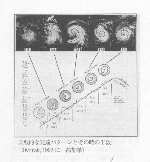
Newer picture? - The chart at top of article looks important historically: the original 1973 technique. But its a bit crude. Doesn't the NOAA have a newer, updated version (public domain) that is cleaner & updated? The could both be in the article.
The last paper by Dvorak in the public domain is from 1984. Wikipedia does normally demand original sources. I have uploaded the two images on the right from the 1984 paper Option 1Option 2. An improvement from your perspective?
Thegreatdr (
talk)
21:24, 21 November 2012 (UTC)reply
Ambiguous: section title "Evolution" is ambiguous: does it mean evolution of the creation of the technique? or evolution of a cyclone as it develops? See also note above about changing the Ev section to be "comparison with other techniques"
See if the new section titles are favorable. I'm trying to avoid the terms Dvorak and technique in the section headers, per the Manual of Style.
Thegreatdr (
talk)
21:32, 21 November 2012 (UTC)reply
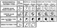
Letter classification V -Z : The chart at top shows five different development lifespans: V to Z. Those needs to be explained in the article.
Fact clarification: "... strength more than the constrained 2.5 T numbers per day," - Can that be clarified? It sounds like there is a rule that storms can only change their value by a maximum of 2.5 per day. If that is true, that "rule" or constraint should be explicitly mentioned before this sentence, perhaps much earlier in the article.
Mention other classification system: The
Saffir–Simpson hurricane scale is widely used in the US. A layman reader will want the article to mention the SSHS, briefly define it, and explain how the Dvorak technique is used in relation to SSH: are they two different approaches to the same thing? Or does one just supplement the other? Why does SSHS only have 5 levels, yet Dvorak has more? Which system is more widely used by weather professionals in their own writings? etc.
The reason I haven't mentioned Saffir-Simpson is that it is meant to provide people some idea of what type of wind damage to expect for landfalling systems, while this method is merely assigning tropical cyclone intensity to meteorologists who use the information to then assign the maximum sustained winds. I can see where one might think they are related, since they both deal with wind, but one is assigning an intensity for meteorologists, while the other is giving the public an idea of the type of damage to expect with tropical cyclones of a certain intensity. They appeal to two different groups of people.
Thegreatdr (
talk)
18:22, 23 November 2012 (UTC)reply
Red link: - Probably should create a red link for
Hebert-Poteat, per
WP:RED, so future readers will have their attention drawn to the fact that a new article needs to be created. For example, see
Extratropical transition technique where it is red-linked.
Ambiguous - "Subtropical cyclone intensity cannot be determined using this technique, ..." - Not clear what "this technique" is, since a couple of techniques were mentioned in the preceding few sentences. Just re-state the name of the technique so reader doesn't have to guess.
Caption confusing: "Subtropical Storm Andrea of 2007, a system which the Dvorak technique would improperly diagnose cyclone intensity" - The reader will want a couple more facts on this: (1) what is it about Andrea that would cause the DT to fail? and (2) citation needed, since it is identifying a flaw in the DT, the reader may want to go read more about this flaw. I looked in the article body, but did not see any other metion of Andrea in the article. Also, the grammar of that caption is not quite right. Maybe "The Dvorak technique does not correctly diagnose cyclone intensity for storms like
Andrea because blah, blah."
That's about all I can find. Overall it is a great article, with good graphics and nice prose! If you can address the points above, it will be GA status.
End comments from Noleander. --15:46, 21 November 2012 (UTC)
I have just modified 2 external links on
Dvorak technique. Please take a moment to review
my edit. If you have any questions, or need the bot to ignore the links, or the page altogether, please visit
this simple FaQ for additional information. I made the following changes:
When you have finished reviewing my changes, you may follow the instructions on the template below to fix any issues with the URLs.
This message was posted before February 2018.
After February 2018, "External links modified" talk page sections are no longer generated or monitored by InternetArchiveBot. No special action is required regarding these talk page notices, other than
regular verification using the archive tool instructions below. Editors
have permission to delete these "External links modified" talk page sections if they want to de-clutter talk pages, but see the
RfC before doing mass systematic removals. This message is updated dynamically through the template {{
source check}} (last update: 5 June 2024).
If you have discovered URLs which were erroneously considered dead by the bot, you can report them with
this tool.
If you found an error with any archives or the URLs themselves, you can fix them with
this tool.
This article is within the scope of WikiProject Weather, which collaborates on weather and related subjects on Wikipedia. To participate, help improve this article or visit the
project page for details.
More info. Perhaps you could mention storms where Dvorak constraints were broken. That occurred during Elida during the 2002 EPAC season. Also, what are the highest ones? IIRC, Angela in 1995 got up to an 8, along with 2 other storms.
Hurricanehink (
talk)
03:42, 22 May 2006 (UTC)reply
I think the Dvorak constraints are not very useful. They simply, (if my understanding is correct) give a guideline of how fast a typical storm will stregthen. Is based on statistical data, does not consider the environment of the hurricane. Also 8.0 is the highest possible Dvorak number.
TimL03:18, 26 May 2006 (UTC)reply
Part of the text seems to be cut off at the end. Also, I've seen a chart somewhere with a column for the minimum pressure estimates for pacific basin storms as they have a lower pressure in general. I can't remember if it was on the NHC site or in Dvorak's paper itself. I have it saved somewhere on my computer if you decide to add it and can't locate the numbers.
Dr Denim03:46, 22 May 2006 (UTC)reply
oh and I just remembered something else worth adding is the usage of the Dvorak technique in forecasting intensity changes
Dr Denim03:57, 22 May 2006 (UTC)reply
Further research indicates to me that the Dvorak technique is not skilled at forecasting intensity. It is not mentioned by the NHC in their year-end accuracy report, so I don't think it is worth a mention here.
TimL03:18, 26 May 2006 (UTC)reply
I think it might still be worth mentioning as it is part of the technique even if it isn't used often and I'd assume it is just as reliable as the persistance model for intensity change...can't remember what that was called...
Dr Denim12:25, 26 May 2006 (UTC)reply
The important thing to remember about the Dvorak technique is that it isn't used as a model to numerically predict intensities, but rather just a "the intensity is increasing/decreasing/steady state" kind of thing, which can just as easily be determined by simply looking at a satellite image. It's more of a predictor of what trend is currently underway in the cyclone's structure/intensity. And since its forecasting role is so limited, and it is not a model of any sort, it isn't mentioned in the NHC's verification reports.
WindRunner18:56, 27 May 2006 (UTC)reply
I remember Elida, she was crazy. Discussion of breaking Dvorak:
[1][2][3]:
ELIDA HAS BROKEN ALL THE DVORAK RULES. IT HAS INTENSIFIED RAPIDLY
SINCE YESTERDAY AND DATA T-NUMBERS ARE UP TO 6.0 PLUS WITH OBJECTIVE
NUMBERS REACHING 6.5 DURING THE PAST HOUR OR SO.
Something else that might be handy is an example satelite image...and for that matter if we could somehow upload the drawings(or replications of them) of the satelite images for different CI numbers that apear in his essay on the technique that'd be really helpful...if I could find a way to make the images on my computer or get my scanned drawings to look smoother I'd be willing to make them...I have them sketched somewhere...anywho
Dr Denim11:43, 23 May 2006 (UTC)reply
Yes, I thought that might be a compelling addition to the article. I have not seen the essay, nor do I know how to access it, but an idea I had was to grab public domain satellite image for storms of a certain CI and show them together. There could be a set of images for several 3.0 CI storms and another set for several 4.0 CI storms.
TimL19:25, 23 May 2006 (UTC)reply
well...if you live near a university that has a meteorology program then they might have one...if I get the chance to stop by school sometime this summer I'll have to try and photocopy the essay so I can have a copy of it on hand...I've looked around the noaa websites for it but haven't had any luck...mayhap I'll look around on google or something...anywho...those reference images would be really helpful in explaining the technique...especially to someone who isn't familiar with the terminology. I'll look around and see if I can't find a copy of the essay online somewhere
Dr Denim20:06, 23 May 2006 (UTC)reply
here's a link to the abstract so that the citation information can be added by someone at least...still looking for an online version though
ah here's an image of one of the several charts in the paper...the website's messed up on this computer(probably in an asian charater set) so I can't tell if it's public domain or not (although considering the fact that I can't find the essay itself it's probably not public domain)...anywho
Okay...so I uploaded the notes I took when I read the essay onto my deviant art account...although I never got around to finishing the essay but I got a good chunk of it done...
Could we have a wider range of images showing TCs at various CI's. 2.5, 3.0 and 3.5 isn't much of a range. It should give an impression of how it varies from 2.0 up to 8.0. And ideally it shouldn't be solely Atlantic storms.--
Nilfanion (
talk)
09:25, 12 June 2006 (UTC)reply
That is quite reasonable. Other basins are doable as long as they have readily available advisory/discussion archives which mention T-numbers. Since the other basins rely soley on the Dvorak technique(i.e no reconaissance) I would be suprised if they didn't.
Images could also be broken down into the various pattern types, though this would require some skill with the dvorak technique. There is a presenation I should throw in the external links which has drawings of the various pattern types at different intensities.
TimL22:52, 12 June 2006 (UTC)reply
I removed all references to AFWA (KGWC) providing Dvorak fixes on tropical cyclones. I work there and know they no longer provide fixes. This was mentioned in the 2007 National Hurricane Operations Plan. Also, in the 2007 Office of the Federal Coordinator for Meteorology Action Items list, Point #12, it said the following:
"Due to recent personnel and funding cuts, the Air Force Weather Agency (AFWA) can no longer dedicate the resources needed to sustain tropical cyclone satellite imagery surveillance and analysis support to the National Hurricane Operations Plan. This cessation of support requires changes in the NHOP to reflect the AFWA termination but continuance of support on request, resources permitting, by the 17th Operational Weather Squadron Meteorological Satellite Operations (SATOPS) Flight (17 OWS/WXJ), Joint Typhoon Warning Center, Pearl Harbor, HI to the Central Pacific Hurricane Center.)
Lead: must mention the more commonly-use "Level 1 to 5" hurricane intensity scale: compare and contrast with Dvorak (because readers, at least in US, will have heard the 1-to-5 frequently in the news reports)
The table below compared the T numbers used in the Dvorak scale to hurricane categories. I don't see why we'd need to add this sort of information into the lead. The lead is meant to be a broad summary of the article below.
Thegreatdr (
talk)
21:06, 21 November 2012 (UTC)reply
Lead: Must explain if hurricanes are included or not
I believe I have now addressed this. Remember that we can't introduce POV into the article, so I've tried to use more global terms. Tropical cyclones include TD, TS, and HU/TY/Intense TC intensities explicitly.
Thegreatdr (
talk)
21:09, 21 November 2012 (UTC)reply
What is the POV issue? I thought Hurricane simply means a cyclone in the Atlantic, no? Many readers will know what a hurricane is, but will not be familiar with cyclone. --
Noleander (
talk)
18:26, 23 November 2012 (UTC)reply
Footnote in lead: Why is footnote #1 in the lead section? footnotes are optional there, and all material in lead is supposed to also be in the body (where the footnote should normally be placed).
If you want me to remove it, I can. Some people who review GA articles demand it, even if it is optional, as you say. Other references further down the article cover this.
Thegreatdr (
talk)
21:12, 21 November 2012 (UTC)reply
No need to measure wind speed (fly aircraft into?) - I don't see a comparison of Dvorak vs other intensity schemes which require measuring wind speed. I would think that a HUGE point is that the DT is much simpler/cheaper/safer than flying a plane into a hurricane, etc. Maybe there could be an entire section in the article on "DT contrasted with other estimation approaches" or similar. I see that the section "Evolution" mentions a few other techniques: consider re-casting that section to be "other techniques" section.
Newer picture? - The chart at top of article looks important historically: the original 1973 technique. But its a bit crude. Doesn't the NOAA have a newer, updated version (public domain) that is cleaner & updated? The could both be in the article.
The last paper by Dvorak in the public domain is from 1984. Wikipedia does normally demand original sources. I have uploaded the two images on the right from the 1984 paper Option 1Option 2. An improvement from your perspective?
Thegreatdr (
talk)
21:24, 21 November 2012 (UTC)reply
Ambiguous: section title "Evolution" is ambiguous: does it mean evolution of the creation of the technique? or evolution of a cyclone as it develops? See also note above about changing the Ev section to be "comparison with other techniques"
See if the new section titles are favorable. I'm trying to avoid the terms Dvorak and technique in the section headers, per the Manual of Style.
Thegreatdr (
talk)
21:32, 21 November 2012 (UTC)reply
Letter classification V -Z : The chart at top shows five different development lifespans: V to Z. Those needs to be explained in the article.
Fact clarification: "... strength more than the constrained 2.5 T numbers per day," - Can that be clarified? It sounds like there is a rule that storms can only change their value by a maximum of 2.5 per day. If that is true, that "rule" or constraint should be explicitly mentioned before this sentence, perhaps much earlier in the article.
Mention other classification system: The
Saffir–Simpson hurricane scale is widely used in the US. A layman reader will want the article to mention the SSHS, briefly define it, and explain how the Dvorak technique is used in relation to SSH: are they two different approaches to the same thing? Or does one just supplement the other? Why does SSHS only have 5 levels, yet Dvorak has more? Which system is more widely used by weather professionals in their own writings? etc.
The reason I haven't mentioned Saffir-Simpson is that it is meant to provide people some idea of what type of wind damage to expect for landfalling systems, while this method is merely assigning tropical cyclone intensity to meteorologists who use the information to then assign the maximum sustained winds. I can see where one might think they are related, since they both deal with wind, but one is assigning an intensity for meteorologists, while the other is giving the public an idea of the type of damage to expect with tropical cyclones of a certain intensity. They appeal to two different groups of people.
Thegreatdr (
talk)
18:22, 23 November 2012 (UTC)reply
Red link: - Probably should create a red link for
Hebert-Poteat, per
WP:RED, so future readers will have their attention drawn to the fact that a new article needs to be created. For example, see
Extratropical transition technique where it is red-linked.
Ambiguous - "Subtropical cyclone intensity cannot be determined using this technique, ..." - Not clear what "this technique" is, since a couple of techniques were mentioned in the preceding few sentences. Just re-state the name of the technique so reader doesn't have to guess.
Caption confusing: "Subtropical Storm Andrea of 2007, a system which the Dvorak technique would improperly diagnose cyclone intensity" - The reader will want a couple more facts on this: (1) what is it about Andrea that would cause the DT to fail? and (2) citation needed, since it is identifying a flaw in the DT, the reader may want to go read more about this flaw. I looked in the article body, but did not see any other metion of Andrea in the article. Also, the grammar of that caption is not quite right. Maybe "The Dvorak technique does not correctly diagnose cyclone intensity for storms like
Andrea because blah, blah."
That's about all I can find. Overall it is a great article, with good graphics and nice prose! If you can address the points above, it will be GA status.
End comments from Noleander. --15:46, 21 November 2012 (UTC)
I have just modified 2 external links on
Dvorak technique. Please take a moment to review
my edit. If you have any questions, or need the bot to ignore the links, or the page altogether, please visit
this simple FaQ for additional information. I made the following changes:
When you have finished reviewing my changes, you may follow the instructions on the template below to fix any issues with the URLs.
This message was posted before February 2018.
After February 2018, "External links modified" talk page sections are no longer generated or monitored by InternetArchiveBot. No special action is required regarding these talk page notices, other than
regular verification using the archive tool instructions below. Editors
have permission to delete these "External links modified" talk page sections if they want to de-clutter talk pages, but see the
RfC before doing mass systematic removals. This message is updated dynamically through the template {{
source check}} (last update: 5 June 2024).
If you have discovered URLs which were erroneously considered dead by the bot, you can report them with
this tool.
If you found an error with any archives or the URLs themselves, you can fix them with
this tool.


