| This is an archive of past discussions. Do not edit the contents of this page. If you wish to start a new discussion or revive an old one, please do so on the current talk page. |
| Archive 55 | ← | Archive 58 | Archive 59 | Archive 60 | Archive 61 | Archive 62 | → | Archive 65 |
Al Arisha
User:LightandDark2000 Al Arisha was not taken, the YPG offensive came from east and west of Shidadi, they bypassed the northern countryside and created an ISIS pocket. Your edit and source [1] [2] do not match, "last bastion in Hasaka" is highly ambiguous and could just mean that Shidadi is the last important city they had, it doesn't mean Arisha itself was liberated. I know we don't copy from maps, but when other map makers [3] [4] including pro-YPG ones are saying Arisha is encircled, I suggest we give them some credibility. So we should revert all villages that are not specifically confirmed to be liberated, unless it's a small village surrounded by liberated villages, etc. But Arisha is a massive pocket.
That said, Twitter sources are all reporting a massive ISIS counter attack at Shidadi while pro-YPG sources are mum. SOHR itself says there are conflicting reports on whether Daesh regained territory inside or near Shidadi or not, so let's not rule out a reversal. [5] NightShadeAEB ( talk) 00:12, 22 February 2016 (UTC)
- Al-Arishah was actually captured back in late December 2015. SDF sources reported that they secured the entire corridor between Al-Hasakah city and Al-Shaddadi on February 20 (See
[6],
[7],
[8]). As for the recent counterattack, it was reported that ISIL was kicked out of Al-Shaddadi (western suburbs) ...again.
[9]
LightandDark2000 (
talk)
00:16, 22 February 2016 (UTC)
- I'm pretty aware of this counterattack, but ISIL never really recaptured the city or regained any significant ground during the course of their attack, so it isn't really a reversal. There might still be some pockets of ISIL resistance in Al-Shaddadi city (esp. since the SDF hasn't fully combed the city yet), but that doesn't mean that ISIL is actually in control of the city.
LightandDark2000 (
talk)
00:21, 22 February 2016 (UTC)
- I read all three articles twice, even the Arabic one, and I cannot find a single reference to the Hasaka-Shidadi corridor you mentioned, let alone a specific reference to Arisha and its surroundings. What do you mean? If these are your only sources then they really are not enough. As for Arisha, not a single source from December 2015 said it was taken, hence why we were expecting the assault on Shidadi to begin with Arisha and the dam, but instead it came from Khabour and Iraq instead. Arisha is really not liberated yet, the SDF are too busy defending Shidadi city at the moment. Even the Wikimapia editor(s) are showing a Khabour pocket. That's three map sources affirming Arisha is under ISIS, in addition to the absence of any valid sources that say Arisha is liberated. [10]
- I'm pretty aware of this counterattack, but ISIL never really recaptured the city or regained any significant ground during the course of their attack, so it isn't really a reversal. There might still be some pockets of ISIL resistance in Al-Shaddadi city (esp. since the SDF hasn't fully combed the city yet), but that doesn't mean that ISIL is actually in control of the city.
LightandDark2000 (
talk)
00:21, 22 February 2016 (UTC)
- Also how is Markada liberated? It's an important village between Shidadi and Deir ez-Zour. No source has confirmed its fall, especially not while Daesh is counterattacking at present. What sources are you using for all these edits? The ones you posted say nothing about Markada or Arisha. NightShadeAEB ( talk) 01:11, 22 February 2016 (UTC)
- Here are sources that Ajaja village in Arisha subdistrict was hit by air strikes on January 28 [11] by Qassioun, and Qana northwest of Arisha was hit on January 30 according to Step [12]. Hasaka Is Being Slaughtered Silently also reported air strikes on Arisha proper on February 14 [13] and confirms Ajaja air strike from January 28 [14]. So it's questionable at best to talk about Arisha being liberated.
- Now things get confusing: an Al Aan article says Arisha and surrounding districts were liberated with little resistance on the road to Shidadi. [15] This certainly paints a confusing picture. But at least we know for sure Arisha wasn't liberated in December. NightShadeAEB ( talk) 01:26, 22 February 2016 (UTC)
- Opposition media such as Orient and Zaman al Wasl report al Arisha is under Daesh but besieged. [16] [17] Incidentally, Zaman also says Daesh is amassing at Markada to counter-attack Shidadi, and that Daesh recaptured Adla and Azawi near Shidadi. I'll change all villages mentioned by name in Zaman al Wasl. NightShadeAEB ( talk) 01:32, 22 February 2016 (UTC)
- Now even Aymenn Jawad says the SDF never really retook the whole of Shidadi. The current mixed control icon (which I didn't put) is thus most accurate. [18] NightShadeAEB ( talk) 02:15, 22 February 2016 (UTC)
Editing according to the result of this conversation. PutItOnAMap ( talk) 20:56, 23 February 2016 (UTC)
Hasakah Province
Are the villages between Arishah-Shadaddi actually held by IS as indicated on the map or have they just not been updated? If so please update them because it makes the map look very inaccurate, also as far as I know, these villages have been captured by IS and IS now only has control south of Fadhgami. 82.153.113.72 ( talk) 20:37, 23 February 2016 (UTC)
What has happened is that SDF gains have probably been overestimated and we have left IS areas stranded amongst SDF areas that were not actually retaken. We're fixing it now. PutItOnAMap ( talk) 20:57, 23 February 2016 (UTC)
Chaging grey from 'Al Nusra' to 'Al Qaeda' on our map
The recent prevalence of Jund al-Aqsa, an al-Qaeda group not part of Nusra itself, and the Khorasan group, means that we have put up grey markers where Al-Nusra aren't present. I propose we change the labelling on our map for the grey colour to 'Al Qaeda (includes Al Nusra, Jund al-Aqsa, and the Khorasan gruop)' or 'Al Qaeda (predominantly Al Nusra)'. What do you all think of this? PutItOnAMap ( talk) 15:22, 23 February 2016 (UTC)
- We should say Al Nusra and other AQ linked groups. The issue is that there are many such groups that are a grey area, such as Harakat al Muthanna in Daraa, and Junud al Sham and Jabhat Ansar al Din in Aleppo and Latakia. Jabhat Ansar al Din contains Harakat al Fajr al Islamiyya, a native Aleppo group, and Sham al Islam, a Moroccan-Chechen jihadist group blacklisted by the US. Junud al Sham's leader Muslim al Shishani is blacklisted by the US. There's also the Turkestan and Imam Bukhari groups, which include Uyghurs and Uzbeks and are understand to be tied to AQ. There are many small groups in Aleppo like Ansar al Khilafa that might be considered AQ linked. Harakat al Muthanna is "neutral" on ISIS and is being attacked by the FSA for being jihadi; they in turn made indirect takfir to some FSA factions last year. Then there's obviously Ahrar al Sham, widely considered to be mainstream rebel but also having ties to AQ type groups especially in Idlib and Latakia. And Ansar al Islam, a junior partner of Ahrar al Sham that also hangs out with Latakia jihadis. Then there's the small groups of Jaysh al Fateh, like Liwa al Haq and Ajnad al Sham, I also don't know if these are jihadi or just Islamist rebels. Jaysh al Sunna, another Jaysh al Fateh group, is former FSA from Homs, but got bombed by the US while it was targeting Nusra. And Khorasan, it's not a real group, just a cell of individuals that could be embedded with any group on the ground.
- So assessing who's AQ and who isn't, is a very tough game in Syria. Just say "Nusra and other AQ linked groups", or if you want, "Nusra and other Salafi-jihadi groups", since Salafi-jihadism is the common term used to describe the ideology of groups like AQ and ISIS. A group may be exactly like AQ without being linked to AQ, for instance. It's up to you. NightShadeAEB ( talk) 15:51, 23 February 2016 (UTC)
I know many of these groups have ties to AQ, but Jund al-Aqsa and al Nusra are directly linked - i.e. they are part of AQ. Therefore, shouldn't Jund al-Aqsa be represented in the same colour as al-Nusra? Point taken about Khorasan. PutItOnAMap ( talk) 18:22, 23 February 2016 (UTC)
- Jund al Aqsa isn't an official AQ arm though. They are linked only operationally and ideologically. But it's true that Jund al Aqsa appears to be the most extremist opposition faction, even more extreme than Nusra. I would go on a hunch to say it is more AQ than the other small factions but that needs more research. I'm fine with including both Nusra and AQ in grey, which we already do, I'm just raising the question about other groups too. NightShadeAEB ( talk) 20:13, 23 February 2016 (UTC)
I thought Jund al Aqsa was official AQ. It only left al-Nusra, but it remained a part of the Al-Qaeda network, so it is part of Al-Qaeda, even if it is not its official Syrian affiliate. PutItOnAMap ( talk) 20:33, 23 February 2016 (UTC)
The reality is that in this war there is hundreds of jihadi-rebel groups, and they can all be linked between them or not depending to the moments and situations in the ground. So it's impossible to say who is AQ or not, but I think that the situation will quickly clarify with the recent agreement of truce, we will be able to put grey those who refuse (AQ & co), and green those who accept it (other rebels). 82.233.227.191 ( talk) 23:37, 23 February 2016 (UTC)
- ISIS and Syrian rebels engage in joint offensive vs SAA https://www.almasdarnews.com/article/isis-and-syrian-rebels-halt-hostilities-and-engage-in-joint-offensive-vs-saa/ We cannot have lime in the large area between Abu Duhur and Khanasir and then suddenly a massive "grey" offensive eastwards. It makes no sense. If JaA launched a massive offensive to Khanasir, Islamists/Al Qaeda (grey) must hold large part of this south Aleppo/north Hama area, and not rebels (lime). It is increasingly important as they are not part of a ceasefire/truce and may still be in hostilities with SAA and other groups even if the truce holds Ariskar ( talk) 08:07, 24 February 2016 (UTC)
I know there are a lot of Salafist and extremist groups around, but the only two that are directly part of AQ itself are Jund al-Aqsa and al-Nusra, even if others have sympathies with AQ, yes? As for AQ launching offensives through green areas, their fighters may have freedom of movement in some rebel-held areas to launch offensives without actually having control in those places. PutItOnAMap ( talk) 10:59, 24 February 2016 (UTC)
Blouzah village, south Aleppo.
I can't find the SOHR source, but I'm pretty sure rebels recaptured this village. What do you think ?
- Apparently video from inside the village
- Other source
- Other source2 DuckZz ( talk) 23:02, 22 February 2016 (UTC)
If they're not pro-opp sources (or if they are reliable pro-opp sources), we can use them to indicate recapture. PutItOnAMap ( talk) 18:23, 23 February 2016 (UTC)
PutItOnAMap The best would be to just put it as contested. DuckZz ( talk) 21:55, 23 February 2016 (UTC)
The best would be to find a non-pro-opp source for a pro-opp advance, in my opinion. I do recall someone mentioning a SOHR source; finding the URL will be enough. PutItOnAMap ( talk) 11:41, 24 February 2016 (UTC)
On Zaman al Wassl
Posting this here for archival purposes since it was deleted. And I still have one thing to add.
Do you speak Arabic? Because my article clearly mentions all those villages, and many more I couldn't locate. [19]
- "مصادر صحفية، قالت لـ"زمان الوصل" إن مؤتمراً صحفياً أعلنت عنه قيادة تحالف "قوات سوريا الديمقراطية"، تأجل بعد أن كان مقرراً عقده اليوم الأحد للإعلان رسمياً عن السيطرة على مدينة "الشدادي" وبلدة "العريشة" والقرى المحيطة بهما، وسط أنباء عن تحصن مقاتلي التنظيم في بعض أحياء مدينة "الشدادي"، وفي بلدة "العريشة" وقرى (عجاجة، الحدادية، تل احمر، ام ركيبة، الرشيدية، الخرايج، خربة السم، الحمدانية، والصالحية)، وجميعها واقعة شمال منطقة "الشدادي" قرب سد الحسكة الجنوبي على نهر الخابور."
[20] NightShadeAEB ( talk) 13:45, 22 February 2016 (UTC)
- Apparently SDF wanted to announce liberation of both Arisha and Shidadi (which means Arisha wasn't free yet), but it seems ISIS is still in part of Shidadi, as well as in Arisha, Ajaja, Hadadiya, Tel Ahmar, Um Rukayba, Rashidiya, Kharayij, Khirbat al Sim, Hamdaniya, and Salihiya. This is a translation of the relevant part. NightShadeAEB ( talk) NightShadeAEB ( talk) 14:52, 22 February 2016 (UTC)
- I guess that those villages are all between Al-Arisha and Al-Shaddadi, along the Khabur River (esp. from the sound of the names I read). Since that area has already been marked up, it's pointless to clutter up the map by adding more villages there. LightandDark2000 ( talk) 02:01, 23 February 2016 (UTC)
- LightandDark2000 I am not asking to add new villages, I am asking that you revert your revert of my edit that was the result of you not being able to read my source properly. [21] You found a source for Aazawi, but Adlah and Khirbat al Sim should stay black. ( talk) 10:06, 23 February 2016 (UTC)
- The article didn't mention Aadlah or Khirbat al Samm. And SOHR reported that the SDF captured (or recaptured) 9 villages south of Al-Shaddadi. LightandDark2000 ( talk) 10:09, 23 February 2016 (UTC)
- I literally just copied and pasted the relevant Arabic part with my own translation for Khirbet al Sim (خربة السم). As for Adlah and Aazawi, the excerpt I provided you with doesn't mention them, but the article itself does. It mentioned every single village I changed, except the one south of Markada which I used my best judgement for. If SOHR says they recaptured Adlah then fine, but it and Aazawi were still black when you reverted them without a source, and my source clearly mentions them in plain Arabic.
- Here is the excerpt about Adlah and Aazawi, it's the second paragraph:
- "وأفاد مصدر محلي بأن تنظيم "الدولة الإسلامية" استعاد قريتي "عدلة" و"العزاوي" جنوب مدينة "الشدادي"، خلال مواجهات مع تحالف "القوات الديمقراطية" على الضفة الغربية لنهر الخابور، تخللها تفجير التنظيم مفخخات استهدفت تجمعات للتحالف هناك."
- Please don't do this again next time. Don't revert unless you understand the original source, and once the source is clarified revert your own revert since we have a 1RR rule and it's a pain to correct mistakes without violating it. Thank you. NightShadeAEB ( talk) 10:22, 23 February 2016 (UTC)
- Please don't forget to change Khirbet al Sim. NightShadeAEB ( talk) 10:24, 23 February 2016 (UTC)
- Also change al Arisha - your source from December is ambiguous, but I found many sources in January that it is hit by air strikes (outlined in our previous discussion
[22], and my Zaman al Wassl article says it is currently under ISIS control too.
LightandDark2000
NightShadeAEB (
talk)
10:30, 23 February 2016 (UTC)
- Al-Arisha town has also been referred to as "Al-Arisha District" (it was referred to as such in
an article about the town while it was still under ISIL control in early December 2015). The SDF couldn't have set up an HQ in the town of Al-Arisha (much less gotten attacked by Pro-Assad militias there) unless they had actually captured it. And if ISIL was still in the town then, ISIL would have attacked the SDF as well, which would have been mentioned in the article. Also, airstrikes don;t necessarily mean that the town is under ISIL control. It very well could have been assaulted; Al-Shaddadi was struck by numerous airstrikes in the past two days, yet ISIL wasn't in control of the city since February 19, they were only trying to re-enter the city. (Oddly enough, you said
this source details that Al-Arisha was taken by the SDF. Regardless of the date, since it is in SDF hands, it's pointless to reverse this change.)
LightandDark2000 (
talk)
10:33, 23 February 2016 (UTC)
- In addition to the new SOHR source I provided, Al-Masdar also reports that the counterattack in question was fully repelled. (The details covered in the ARA and Al-Masdar articles differ slightly, nonetheless, the latter article plainly shows that the 2-pronged ISIL attack from the west and south of Al-Shaddadi was repelled.) All of the recent SOHR sources I viewed in the past day (Arabic) all of the mentioned clashes are happening south of Al-Shaddadi, which means that they no longer control any areas in Al-Shaddadi's western suburbs either. LightandDark2000 ( talk) 10:38, 23 February 2016 (UTC)
- Al-Arisha town has also been referred to as "Al-Arisha District" (it was referred to as such in
an article about the town while it was still under ISIL control in early December 2015). The SDF couldn't have set up an HQ in the town of Al-Arisha (much less gotten attacked by Pro-Assad militias there) unless they had actually captured it. And if ISIL was still in the town then, ISIL would have attacked the SDF as well, which would have been mentioned in the article. Also, airstrikes don;t necessarily mean that the town is under ISIL control. It very well could have been assaulted; Al-Shaddadi was struck by numerous airstrikes in the past two days, yet ISIL wasn't in control of the city since February 19, they were only trying to re-enter the city. (Oddly enough, you said
this source details that Al-Arisha was taken by the SDF. Regardless of the date, since it is in SDF hands, it's pointless to reverse this change.)
LightandDark2000 (
talk)
10:33, 23 February 2016 (UTC)
- Also change al Arisha - your source from December is ambiguous, but I found many sources in January that it is hit by air strikes (outlined in our previous discussion
[22], and my Zaman al Wassl article says it is currently under ISIS control too.
LightandDark2000
NightShadeAEB (
talk)
10:30, 23 February 2016 (UTC)
- Yes, what I understood is that the SDF attacked from three directions, tried to pass through the Khabour villages but for some reason did not succeed in expelling Daesh from them. That or Al Aan did some faulty original research when they named all those villages. There is not a single source that dates to after the Zaman al Wassl article that says the Khabour villages are liberated, and at least six mappers consider the Khabour pocket to be Daesh [23] [24] [25] [26] [27] A seventh activist even edited Wikipedia's faulty map to more accurately reflect it: [28]. We don't copy from other maps, but that doesn't mean we shouldn't exercise common sense. Why are you the only person I see who insists Arisha district was taken?
- Daesh was certainly inside the city of Shidadi, and the city was definitely contested until yesterday. When a militant group is holed up inside a city, we usually consider this to be contested. Even reliable sources like Aymenn Jawad have said so [29].
- The status of Arisha in December is irrelevant. "Arisha district" could mean anything; it could mean the HQ at the front line closest to Arisha. Who knows? All we know is that Arisha was under multiple air strikes, and being a small town, if it's under air strikes then it was at least momentarily contested. And if it was contested before, what makes you think it couldn't be under Daesh right now? Remember when Daesh withdrew from the Thermal Power Plant pocket, everybody reported it. Why is nobody reporting Daesh withdrawal from the Arisha pocket? We have early sources that say or imply Arisha was SDF, but we have up to date sources that say the opposite, and no source that contradicts them whatsoever.
- So until we can find a source that definitely says Daesh withdrew, revert your edit at Arisha and Khirbat al Samm. NightShadeAEB ( talk) 15:39, 23 February 2016 (UTC)
Because we, as people, despise IS (and I hope we have a plurality here when it comes to that...), we often are slightly too quick or optimistic to 'edit them out of the picture', as it were. Accuracy comes first, and although I think that our mapping of this recent offensive (which has been both rapid and confusing for editors such as ourselves) was handled magnificently by you guys, we ought to be a bit more careful in future with our edits. We have to make clear, neutral judgements, even if IS is utterly repulsive, when it comes to working out who controls what. Always double-check yourselves. PutItOnAMap ( talk) 15:20, 23 February 2016 (UTC)
- Yeah, we definitely have to fact check. Even Rudaw is now saying Shidadi city is contested. Arabic article [30].
- They say SDF denies ISIS is still in the town and ISIS denies losing the town, there is a media blackout regarding who really controls it. But SDF fighters said they couldn't advance inside the city since it's booby trapped. This means it is contested. Usually when one side insists on victory without definite proof, we wait until neutral sources start confirming it. User:LightandDark2000 NightShadeAEB ( talk) 20:10, 23 February 2016 (UTC)
I'm going to make edits according to the discussion here. A pro-SDF source saying Shaddadi is contested means that we must mark it as contested. Plus, Al-Arishah district is the area around the town (countryside with possible checkpoints) not the town itself, and the pro-Assad militias could have attacked SDF forces in it. PutItOnAMap ( talk) 20:34, 23 February 2016 (UTC)
User:PutItOnAMap, the pro-SDF source (Rudaw) does not say the town is contested. The Arabic Rudaw source says ISIS denies they lost the town, and that the SDF denies ISIS is in the town. It does not confirm in its own capacity the town is contested. That the town is reportedly booby trapped, which is slowing down SDF clearing operations does not make the town contested if there is no ISIS in the town (and making that kind of conclusion is OR). PLUS, we have had SOHR (one of the most reliable sources) who confirmed Shaddadi was captured by the SDF and at no point did SOHR state ISIS re-entered the town. Plus both Masdar and ARA news state the ISIS counter-attack was repelled. So, Masdar, ARA news and SDF state attack repelled, SOHR does not say town contested, ISIS claims they in the town. 4 vs 1. I think this makes it reasonable enough to put Shaddadi as SDF-held, but for compromise's sake add a partial black ring to the south (since SDF confirmed ISIS conducted a counter-attack towards the town). However, this is just my suggestion (I won't make any edits myself), so if someone doesn't disagree that's cool, no need for an argument. EkoGraf ( talk) 02:17, 24 February 2016 (UTC)
Isn't the counterattack over? If so, we don't even need to put a black ring there. PutItOnAMap ( talk) 10:41, 24 February 2016 (UTC)
User:PutItOnAMap Yes it seems the counter-attack is over. Personally I think the black ring as well is not needed. But I only suggested it as a compromise if someone was still going to insist the town is contested. EkoGraf ( talk) 12:17, 24 February 2016 (UTC)
I think we're all agreed it's no longer contested, although it was earlier. PutItOnAMap ( talk) 14:22, 24 February 2016 (UTC)
Black - Lime alliance icon
ISIS seems to be coordinating with Jund Al-Aqsa, mainly represented with lime icon in the last Khanaser - Aleppo offensive, having jointly captured Rasm Al Nafal. https://www.almasdarnews.com/article/isis-rebels-attack-the-syrian-army-together-in-southeast-aleppo/
- Should we create a new Black-Lime icon to represent this new IS - "Moderate Islamists" alliance? Ariskar ( talk) 14:09, 22 February 2016 (UTC)
- No. Jund al Aqsa is an al Qaeda group, more radical than Nusra and historically a close friend of ISIS. It is not surprising at all that they are coordinating. Recently Nusra and Ahrar accused Jund al Aqsa of being pro-ISIS, and many of their senior leadership and membership defected to Nusra. So this is just the leftovers coordinating with the only friend they have left, at least it looks like this anyway. Keep it grey for now. NightShadeAEB ( talk) 14:11, 22 February 2016 (UTC)
- Jund al Aqsa is part of the Jaish al-Fateh, represented in Lime-Gray mainly in Idlib. If we reach a consensus JaA are Islamist/Jihadists, we should at least have a gray-black icon to represent their joint military operations with IS. Ariskar ( talk) 14:17, 22 February 2016 (UTC)
Jund Al Aqsa operates in Jaish Al-Fataeh, but this is not a rebel group in itself. Jund Al Aqsa left Al Nusra over its disputes with IS, but it never left al-Qaeda. It is an al-Qaeda linked group and so should be marked in grey. In fact, we should update the colour code on our map: we should not write 'Al Nusra' in grey but 'Al Qaeda' as there are non-Nusra, but Qaeda-linked groups in Syria. E.g. Jund Al Aqsa and the Khorasan group. PutItOnAMap ( talk) 22:02, 22 February 2016 (UTC)
- ISIS and Syrian rebels engage in joint offensive vs SAA https://www.almasdarnews.com/article/isis-and-syrian-rebels-halt-hostilities-and-engage-in-joint-offensive-vs-saa/ Ariskar ( talk) 08:03, 24 February 2016 (UTC)
- We cannot have lime in the large area between Abu Duhur and Khanasir and then suddenly a massive "grey" offensive eastwards. It makes no sense. If JaA launched a massive offensive to Khanasir, Islamists/Al Qaeda (grey) must hold large part of this south Aleppo/north Hama area, and not rebels (lime). It is increasingly important as they are not part of a ceasefire/truce Ariskar ( talk) 08:06, 24 February 2016 (UTC)
As I wrote elsewhere: "I know there are a lot of Salafist and extremist groups around, but the only two that are directly part of AQ itself are Jund al-Aqsa and al-Nusra, even if others have sympathies with AQ, yes? As for AQ launching offensives through green areas, their fighters may have freedom of movement in some rebel-held areas to launch offensives without actually having control in those places." — Preceding unsigned comment added by PutItOnAMap ( talk • contribs) 14:23, 24 February 2016 (UTC)
Status of Mahin?
http://www.voanews.com/content/syria-islamic-state-homs/3206752.html
States Mahin as IS control. Any other sources on that? Tgoll774 ( talk) 02:40, 25 February 2016 (UTC)
- This mistake! This data from some the anti-government activist Jassim al-Homsi who is based in Turkey but all sources including SOHR clear said that town Mahin in a long time under control of SAA and we not have any confirmation that this town retaken ISIS. Also he just said towns like Mahin of al-Qaryatayn. So on based such incorrect data we can't marked the strategic town of Mahin as under ISIS. Sûriyeya ( talk) 09:14, 25 February 2016 (UTC)
- For now clashes going near the town al-Qaryatayn which SAA still try retake from ISIS. Sûriyeya ( talk) 09:21, 25 February 2016 (UTC)
Fah and Khanasir
Fah (east of Aleppo, north of Tal Aran) was retaken by ISIS according to http://www.syriahr.com/?p=158101 Why is Khanasir contested between red and green? It should be red and black. Mughira1395 ( talk) 12:06, 24 February 2016 (UTC)
I have changed it to red and black. Will update with the SOHR source now. PutItOnAMap ( talk) 14:21, 24 February 2016 (UTC)
- SAA retake Khanassir. SOHR Sûriyeya ( talk) 09:07, 25 February 2016 (UTC)
http://aranews.net/2016/02/islamic-state-militants-take-over-syrian-military-base-in-aleppo/
A pro-Kurd source. I don't see a base here, and first I heard of this base. Tgoll774 ( talk) 02:42, 26 February 2016 (UTC)
External links modified
Hello fellow Wikipedians,
I have just added archive links to 12 external links on
Cities and towns during the Syrian Civil War. Please take a moment to review
my edit. If necessary, add {{
cbignore}} after the link to keep me from modifying it. Alternatively, you can add {{
nobots|deny=InternetArchiveBot}} to keep me off the page altogether. I made the following changes:
- Added archive http://web.archive.org/web/20120801035226/http://gulf-times.com/site/topics/article.asp?cu_no=2&item_no=522265&version=1&template_id=37&parent_id=17 to http://www.gulf-times.com/site/topics/article.asp?cu_no=2&item_no=522265&version=1&template_id=37&parent_id=17
- Added archive http://web.archive.org/web/20151224054101/http://www.google.com/hostednews/afp/article/ALeqM5ji0WbnWM_rzlRgPfjKSrEPdCzmKw?docId=CNG.e027e84b338f29df5a62409f0c6ddc57.121 to https://www.google.com/hostednews/afp/article/ALeqM5ji0WbnWM_rzlRgPfjKSrEPdCzmKw?docId=CNG.e027e84b338f29df5a62409f0c6ddc57.121
- Added archive http://web.archive.org/web/20130612210741/http://www.cbsnews.com/8301-501713_162-57494290/syria-tv-says-govt-troops-free-captive-journalists/ to http://www.cbsnews.com/8301-501713_162-57494290/syria-tv-says-govt-troops-free-captive-journalists/
- Added archive http://web.archive.org/web/20140219135542/http://au.news.yahoo.com/world/a/19891334/31-syrian-soldiers-killed-in-bomb-attack-near-capital-monitoring/ to http://au.news.yahoo.com/world/a/19891334/31-syrian-soldiers-killed-in-bomb-attack-near-capital-monitoring/
- Added archive http://web.archive.org/web/20130602101955/http://vancouverdesi.com/news/syrian-army-batters-parts-of-damascus-40-killed/ to http://vancouverdesi.com/news/syrian-army-batters-parts-of-damascus-40-killed/
- Added archive https://web.archive.org/web/20131022170911/http://news.yahoo.com/assads-forces-counter-rebel-gains-syrias-deir-al-170238247.html to http://news.yahoo.com/assads-forces-counter-rebel-gains-syrias-deir-al-170238247.html
- Added archive http://web.archive.org/web/20130801021849/http://www.france24.com/en/20120703-syria-troops-pound-homs-watchdog to http://www.france24.com/en/20120703-syria-troops-pound-homs-watchdog
- Added archive http://web.archive.org/web/20131224113814/http://english.farsnews.com/newstext.php?nn=9107127869 to http://english.farsnews.com/newstext.php?nn=9107127869
- Added archive http://web.archive.org/web/20140328171907/http://www.brisbanetimes.com.au/world/syria-regime-bombards-rebels-20121114-29cds.html to http://www.brisbanetimes.com.au/world/syria-regime-bombards-rebels-20121114-29cds.html
- Added archive http://web.archive.org/web/20130503113338/http://news.yahoo.com/assads-forces-break-rebel-blockade-north-syria-104925711.html to http://news.yahoo.com/assads-forces-break-rebel-blockade-north-syria-104925711.html
- Added archive http://web.archive.org/web/20120331223755/http://news.sky.com:80/home/world-news/article/16198628 to http://news.sky.com/home/world-news/article/16198628
- Added archive http://web.archive.org/web/20140615001337/https://www.youtube.com/watch?v=M3nteE8YNc0 to https://www.youtube.com/watch?v=M3nteE8YNc0
When you have finished reviewing my changes, please set the checked parameter below to true to let others know.
This message was posted before February 2018.
After February 2018, "External links modified" talk page sections are no longer generated or monitored by InternetArchiveBot. No special action is required regarding these talk page notices, other than
regular verification using the archive tool instructions below. Editors
have permission to delete these "External links modified" talk page sections if they want to de-clutter talk pages, but see the
RfC before doing mass systematic removals. This message is updated dynamically through the template {{
source check}} (last update: 5 June 2024).
- If you have discovered URLs which were erroneously considered dead by the bot, you can report them with this tool.
- If you found an error with any archives or the URLs themselves, you can fix them with this tool.
Cheers.— cyberbot II Talk to my owner:Online 10:47, 26 February 2016 (UTC)
Shaykh Aqil (northwest Aleppo) contested
According to this independent source [31] the SAA captured Shaykh Aqil this morning (northwest of Aleppo), but the rebels claimed to had recaptured it a few hours later. Appropriate course of action would be to mark it as contested. Please find the appropriate location on the map and add the dot. Thank you! EkoGraf ( talk) 15:00, 26 February 2016 (UTC)
Sheikh Hilal-Ithriyah road
AlMasdar reports that Al-Hassou, Koujan, and Rasm Seifou were taken by SAA close to Al-Siin. Where are they? Maybe Al-Hassou is here? Paolowalter ( talk) 18:40, 26 February 2016 (UTC)
Saraqib Coordinates Wrong
This is the Saraqib coordinates this map shows for this town. This is off! Saraqib is located here
This must be changed — Preceding unsigned comment added by 2601:C7:8301:8D74:1DB4:BFDC:1999:782E ( talk) 19:07, 26 February 2016 (UTC)
Semi-protected edit request on 27 February 2016
This
edit request to
Module:Syrian Civil War detailed map has been answered. Set the |answered= or |ans= parameter to no to reactivate your request. |
{ lat = "36.400", long = "37.144", mark = "Dot yellow ff4.svg", marksize = "6", label = " Ihras", link = "Ihras", label_size = "0", position = "top" }, Tristat ( talk) 10:28, 27 February 2016 (UTC)
ISIS offensive against SDF in north countryside of Raqqa
SOHR said that ISIS captured larg parts of a town Suluk, village of Hamam Al-Turkman and village and village near Ayn Issa, clashes still in the city of Tall Abayd and in the town of Ain al-Arous. here here here Kurdish sources said about clashes inside a city of Ayn Issa. here here Sûriyeya ( talk) 13:24, 27 February 2016 (UTC)
- Pro-opp. source said ISIS captured part of the city Tall Abyad
here plus SOHR said that the clashes still continued in the city.
here
Sûriyeya (
talk)
13:37, 27 February 2016 (UTC)
- Pro-opp. source said that the ISIS captured the city of Tall Abyad
here but we need the confirmations from the reliable or Kurdish sources.
Sûriyeya (
talk)
13:43, 27 February 2016 (UTC)
- SOHR said Kurdish forces(SDF/YPG) retake Tall Abyad and Ain al-Arous but ISIS still hold Hammam at Turkuman and Al Qantari. here Sûriyeya ( talk) 18:43, 27 February 2016 (UTC)
- Pro-opp. source said that the ISIS captured the city of Tall Abyad
here but we need the confirmations from the reliable or Kurdish sources.
Sûriyeya (
talk)
13:43, 27 February 2016 (UTC)
Important changes !
- 1
Today starts the official truce/casefire in Syria, which means the frontlines won't be active. Airstrikes will continue on ISIS and Nusra, but that doesn't matter. What I want to discuss is the following : Can we now remove the purple icons from the map, at least those who aren't part of a map (Damascus). Because they don't make any sense now. This action will only lower the pressure on our map, and simplify it.
- 2 SOHR reported that Nusra members are withdrewing from several locations in Idlib province. Opposition sources are now writing that Nusra is withdrewing from several Idlib locations to avoid airstrikes on civilians population. Reliable source says that Nusra left Al Bara town and their HQ. He also says that Nusra is moving away from Zawiya mountain area, but that's a lot of villages. DuckZz ( talk) 23:30, 25 February 2016 (UTC)
A ceasefire is a combatent agreement to holt hostile action it is not the same as a truce and no sides are calling it a truce .As for Nusra it is still unclear where they have left and where they are going to — Preceding unsigned comment added by 86.135.157.233 ( talk) 12:37, 26 February 2016 (UTC)
- Another user here, I agree the purple icon could be confusing. However you should change it by community vote and agreement. — Preceding unsigned comment added by 2601:C7:8301:8D74:1DB4:BFDC:1999:782E ( talk) 19:10, 26 February 2016 (UTC)
- DuckZzWe can't edit a map on the basis of assumptions. We can't change a statuse for all towns or villages which is under truce to SAA-held or rebels-held only just a based of assumptions. So or you provide sources which is provide statuse(SAA or FSA held) for these points or must leaved them as of under truce. So we also need again marked as under a truce Fua,Kafraya, Brouma and Deir al-Zaghb. And we must leave on the map al points which was marked as under truce unchanged if there is no other data proving their status. Sûriyeya ( talk) 21:33, 27 February 2016 (UTC)
- This seacfire is very fragile. At least wait for two weeks to see if it is going to hold and where? flash news most propebly it will fall apart in less than a month. so wait and don't erge to do any edits based on a seasefire even those who signed it says it is very fragile and the chances of it standing is low. Helmy1453 ( talk) 23:01, 27 February 2016 (UTC)
Azaz
I have changed the city to pure lime colour. Aymenn Jawad al Tamimi visited the city last year and reported that the Northern Storm FSA of al Jabha al Shamiyya was in control over the town despite a minor Nusra presence. [32] That is even before the withdrawal of Nusra this summer, it was not sufficient to add a grey half to Azaz. In fact I lobbied these forums to make Marea half-grey based on reports that Nusra was arresting the FSA there, but I was ignored. It was not profitable to exaggerate Nusra control in Aleppo it seemed, except for in Idlib to give Nusra bad press. Now that YPG is attacking Azaz, I notice Azaz is suddenly half grey. What gives, guys?
All the Twitter sources about Nusra still being in the Azaz "area" do not specify the city nor any other location, and many of those sources, like https://twitter.com/AbuSaeedHalabi, said that Nusra's reinforcements were only for the Nubl & Zahra fighting, not within the YPG front lines. I am keeping this lime because Nusra only had half control in Marea and Tel Rifaat, until they withdrew in August and released some detainees. There was never any source that reported Azaz under Nusra control except for hysterical YPG fanboys trying to legitimize their assault. Their accusations are not considered reliable as per the rules of this template last I checked. NightShadeAEB ( talk) 18:08, 19 February 2016 (UTC)
- Here is the relevant part: "Situated in the northern countryside of Aleppo province, the town of Azaz–the center of the Azaz district–is the nearest major settlement to the Bab al-Salama border crossing that leads into the southern Turkish city of Kilis. At the present time, Azaz town is controlled by the group Liwa Asifat al-Shamal ("The Northern Storm Brigade"), which is affiliated with the Islamic Front rebel coalition. Also present within Azaz town but lacking any governing authority is Syria's al-Qa'ida affiliate Jabhat al-Nusra. To the east of Azaz town lies the smaller settlement of Sawran, beyond which is a frontline, an area of no-man's land of about 800 meters to a kilometer, and then the localities of Doudyan and Dabiq to the northeast and southeast, solely controlled by the Islamic State (IS). Northern Storm also solely controls the town of Sawran." [33] NightShadeAEB ( talk) 18:19, 19 February 2016 (UTC)
- As expected not two hours and already someone's POV pushing. User: EkoGraf Aymenn Jawad is not unknown, he's a policy researcher well cited in the media for years, and even testified to British parliament. [34] You are seriously telling me somebody who testified on ISIS before the House of Commons is an unknown and his tweet has the same weight as an unknown Twitter user? WP policy cares about sources, not the mediums of a source. A reliable person is still reliable even if he talks to you via Whatsapp, don't liken him to a Twitter-exclusive source.
- I don't understand what you are arguing. Aymenn Jawad visited Azaz himself, and said Nusra doesn't govern, as mentioned above. Furthermore, Nusra has since WITHDRAWN its already small presence into a very minimal one. Yet Azaz was fully green when Nusra had a modest presence, but now that Nusra has a negligible presence you make it half grey, just to coincide with the YPG's assault? Can you explain why Azaz wasn't half grey a year ago, when I tried in vain to bring the question of Nusra control in Marea and Hreytan, but as soon as the YPG attacks I notice that Azaz is half grey? Please revert your own edit as soon as possible. NightShadeAEB ( talk) 20:40, 19 February 2016 (UTC)
- I found the culprit [35], it was here based on a paraphrase of an unknown statement by Fabrice Balanche [36] at Al Monitor, the website with an anti-opposition owner. The author herself is part of "Future of Iran Initiative", seems legit. Anyways, this is either a dishonest paraphrase of what Balanche told them, or Balanche slipped up and fell to the common stereotypes surrounding the opposition. Aymenn Jawad al Tamimi's visit to Azaz strongly refutes it. NightShadeAEB NightShadeAEB ( talk) 20:54, 19 February 2016 (UTC)
- User:NightShadeAEB It doesn't matter who he is. Twitter is simply not permitted per WP policy. Read WP:TWITTER. I have reverted people in the past who made changes to the map based on Twitter, whether they are pro-government or pro-rebel, and will do so in the future. Also, accusing me of POV-pushing from the start instead of trying to discus the issue in a calm manner is not in line with WP policy on assuming good faith from your fellow editors. Nevertheless, I hope you will continue making constructive edits on Wikipedia and improve the quality of its articles. Regards! EkoGraf ( talk) 23:04, 19 February 2016 (UTC)
- That is NOT what WP says, and your attempts at distorting its meaning are definitely not in good faith. Wikipedia is against using unreliable sources or self-published sources about external topics, whether or not it is social media. Aymenn Jawad al Tamimi is neither; you yourself said that he was an unknown Twitter user, implying that if he wasn't it would be different. You are now moving goal posts, and you talk to me about good faith? If you bothered reading my edit summary, and what I just wrote here, my source is not just a single tweet - it's the article published by Aymenn Jawad last year, which he has reaffirmed in the tweet this week. You did not even read or respond to what I just wrote here - this is typical of POV pushers.
- I did my research; I researched who changed it and when, I researched which source was used, and I researched reliable sources on the city of Azaz, and what do you do? You just revert my edit, and I can't stop you because of the 1RR rule. This is extremely frustrating; I may not be active most of the time, but I'm by no means new to this. If you refuse to reason and just do whatever you want, I will call this to the attention of moderators.
- Let me quote User:Tradedia who created this map, about the Twitter of well known individuals:
- "The reference to twitter was more in the context of copying from maps. The problem with maps is that we don’t know when they are guessing and when they are not. Twitter is not a source. Twitter is a media tool. The person writing the tweet is the source. Since Elijah Magnier is a well-known journalist, he is a valid source. So it all depends on the credibility of the person writing the tweet. Anyone can open a twitter account and start relaying rumors. It is important to also not use a source automatically, but assess the credibility of the writer and see what other sources are saying about the same town/situation. Some people who tweet are known to have information about the situation in Syria. So they can be used as a source, while taking into account their bias (no pro-gov/opp/kurd/ISIS sources for gov/opp/kurd/ISIS gains)." [37]
- As you see, I may not be as active as some of you users, but for the few contributions that I make, I am absolutely dedicated enough to go through pages and pages of archived discussion just to achieve clarity. I don't limit myself to a simple edit summary. When those who disagree do not even bother exerting the effort to explain why they disagree, it is very hard to maintain good faith. To conclude, I ask you one last time, please revert your own edit, or provide a source that contradicts mine and has equal or greater credibility. Thank you. NightShadeAEB ( talk) 13:19, 20 February 2016 (UTC)
Nightshade your source is a tweet, for all we know this is you tweeting this random information, tweets are not sources get that through your whabbi dead brain. — Preceding unsigned comment added by 83.71.81.111 ( talk) 14:04, 20 February 2016 (UTC)
- Another one acting in "good faith". To quote a friend, these people are only interested in broadcasting, they have no intention of exchanging information and achieving consensus. And for all I know, User:83.71.81.111, you could be any other member in this template talking without your account. NightShadeAEB ( talk) 14:15, 20 February 2016 (UTC)
- Al Nusra has always had significant presence in Azaz area. It was Al Nusra that attacked US-supported Division 30 in Azaz and Menagh area. And more specific the Muntasar Billah Brigade of Al Nusra has a presence there.
- Al-Nusra replaced Jaysh Muhammad in August 2014 when Juysh Muhammad withdrew from the city. Since then Al Nusra has a significant presence in Azaz and surroundings.
- Of the mosques, one shows the influence of the Jabhat al-Nusra presence in the town: namely, the Mus'ab ibn Umair mosque, whose preacher is a member of Jabhat al-Nusra. This preacher attacked the status quo with the schools in Azaz, describing their teaching programs as "secularist-kafir." To counter what it sees as this pernicious influence, Jabhat al-Nusra has established a teaching institute for the Koran and Shari'a for children in Azaz, and the preacher called in his sermon for families to remove their children from the schools in Azaz and register them in the mosque. The other mosques in Azaz, such as the important al-Maytam al-Islami mosque in the center, are officially "independent" in affiliation, but the aforementioned mosque shows clear Islamic Front influence. Namely, its preacher is a judge on Azaz's Shari'a Committee. In any case, looking at education and religious life together points to a notable competition between Jabhat al-Nusra and Northern Storm (Islamic Front) for influence in the town, which has implications for a wider assessment of relations between the two groups.
- If you want a respectable source for Nusra presence, Reuters as a leading news agency should be more sufficient: http://www.reuters.com/article/us-mideast-crisis-syria-nusra-idUSKCN0Q50TL20150731.
- In contrast there are no reliable sources that back the false claim that Al Nusra fully retreated to Turkey or joined ISIS once the Azaz pocked was clossed of from Idlib province. So the change should be reverted and Azaz and surrounding villages should be back half grey (Al Nusra) and half green (Non-SDF opposition goups). Northern storm as a militant group had only for a very short period full control over the city after Azaz was freed with from ISIS in 2014 with help of the YPJ.-- Niele~enwiki ( talk) 01:48, 28 February 2016 (UTC)
Vandalism,Unreliable sources,Misinterpreation of sources,Breaking the rules of editing
These two users for a long time are intentionally breaking the rules of editing with unreliable sources from facebook also misinterpreting them, by doing this they are directly and intentionally vandalising the map despite the rules that are in effect. 1. AlAboud83 using unreliable facebook sources which he himself doesn't know what are this sources credibility: 1. diff 2. diff
2. LightandDark2000 intentionally misinterpreting sources: 1. diff. 2. diff. 3. diff. Lists129 ( talk) 19:09, 28 February 2016 (UTC)
These are reliable Anti-ISIS,Anti-YPG activist that are reliable,that journalist. Alhanuty ( talk) 19:14, 28 February 2016 (UTC)
- SOHR confirmed that SDF retake Ain al-Arous, Tall Abyad, Nus Tal and some other points from ISIS.
here And reliable source Al Masdar also said The attack on Tell Abyad includes all of the villages in the 4-axes involved; and that the entire assault as a whole was repelled.
here Plus SOHR also later said that the SDF retake all most points which they lost earlier.
Sûriyeya (
talk)
20:02, 28 February 2016 (UTC)
-
Lists129 But according to the source
here which used
AlAboud83 villages of Dashishah, al Shamsani, Sarjin and Qutbah still ISIS-held. So we need marked them as ISIS held. For now only Sarjin marked as ISIS-held.
Sûriyeya (
talk)
21:00, 28 February 2016 (UTC)
- And also Pro-Opp. source said ISIS seized over village Hamam Al Turkam tha located in east of Tall Abyad after surprise withdrew by Kurdish units from village and its outskirt. And source also said that ISIS still use people of Ein Alrous village as human shield to prevent allies air forces to carry out any airstrikes. here But maybe we need more confirmation. What your think guys? Sûriyeya ( talk) 21:05, 28 February 2016 (UTC)
-
Lists129 But according to the source
here which used
AlAboud83 villages of Dashishah, al Shamsani, Sarjin and Qutbah still ISIS-held. So we need marked them as ISIS held. For now only Sarjin marked as ISIS-held.
Sûriyeya (
talk)
21:00, 28 February 2016 (UTC)
- Well this map is not credible anymore when you see someone uses some Pro-Opposition sources to change the status on Isis held places to YPG and also this means now that YPG is inside Deirezzor without the slightest confirmation.
Lists129 (
talk)
23:39, 28 February 2016 (UTC)
- The YPG/SDF has not entered the Deir ez-Zor Province, as far as I know. The location of the village is probably somewhat misplaced, since the various map modules incorporating the Syria module are scaled differently. However, the other changes were made according to reliable sources or followed this map module's rules for editing. LightandDark2000 ( talk) 02:33, 29 February 2016 (UTC)
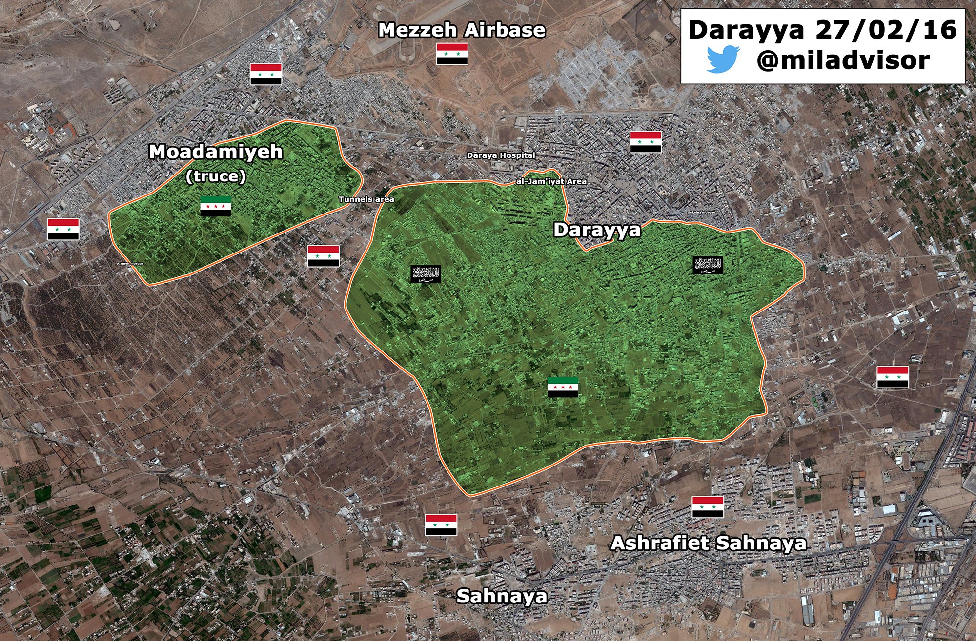
Updated Darayya map
https://pbs.twimg.com/media/CcPeXZSXIAQSlDn.jpg:large https://twitter.com/miladvisor/status/703650467495211008 — Preceding unsigned comment added by 190.200.98.127 ( talk) 10:57, 29 February 2016 (UTC)
Al-Masdar, pro-gov sources and Al-Nusra (grey) versus opposition (green)
This is in reference to my revert of the following edit. The section authorizing the use of Al-Masdar as a reliable source explicitly says: "we cannot use Al-Masdar to decide if a town is held by Al-Nusra or rebels or joint control between them. Al-Masdar has a tendency to exaggerate the role of al-Qaeda, Al-Nusra, jihadists, etc." This also applies even more to pro-gov sources. Tradedia talk 21:02, 27 February 2016 (UTC)
- Like it is not true... without hardcore jihadists like nusra,ahrar,chechens fsa would disappear in weeks. Totholio ( talk) 08:52, 29 February 2016 (UTC)
- And without the Islamists coming in from Lebanon, Ruskies, and radical-as-fuck Iranians propping up the Assad regime, it would be gone within weeks, as well. Don't descend into ad hominem attacks. That's not something you're going to win at, when the government you support has led a five war war against its own people in an attempt to suppress the will of the people, Totholio. 208.92.227.84 ( talk) 17:59, 29 February 2016 (UTC)
- Not sure what are you talking about, you should go to twitter al nusra fanboy pages. The iranian/iraqi/afghan/russian intervention happened AFTER jihadists from 60 countries invaded Syria not before. Will of the people means hundreds of beheading videos from all over Syria? nice revolution with 80% of the population under Assad. Everyone knows who is not biased that this war plan was made after 2006 SAA supporting Hezbollah and making the qatar-saudi-turkish-EU gas pipeline impossible. Totholio ( talk) 18:24, 29 February 2016 (UTC)
- Please, we should argument like adult human beings... 84.138.71.101 ( talk) 19:31, 29 February 2016 (UTC)
Ceasefire
The scheduled ceasefire at midnight has taken effect. I think towns marked as contested between government and rebels, especially near Homs between government and rebels should be changed to mixed/stable control to indicate this. If there are reports of more fighting, then we can change them back. Thoughts? — Preceding unsigned comment added by 2601:C7:8301:8D74:1DB4:BFDC:1999:782E ( talk) 23:48, 26 February 2016 (UTC)
- No because these are Al Nusrat and IS areas the ceasefire those not apply to these areas Russinas claim"so far 45 "moderate" Terrorists have made contact with the Russian officers in Latakia about laying down their arms and returning to Syrian society" it is to early to make changes in these areas until it is seen who is abiding by the ceasefire in surrounded areas with very little ammo/food/supplies/men or wiggle room in negotiation about surrendering which some of them have already agereed to do and free the civilians that are being held at gunpoint from reaching safe Government held areas. — Preceding unsigned comment added by 213.94.233.92 ( talk) 14:22, 27 February 2016 (UTC)
Biased, much? 2601:C7:8301:8D74:1DB4:BFDC:1999:782E ( talk) 20:40, 27 February 2016 (UTC)
Truth too much to handle, the goat riding spawn of Saten (ISIS, Al Nusrat, FSA) propaganda is not working, you better make a few more dead children videos but make sure they are not acting this time, some one may believe you.... — Preceding unsigned comment added by 213.94.232.239 ( talk) 12:16, 2 March 2016 (UTC)
Ayn Daqnah + Shaykh Isa SDF or FSA held?
Please note I am not saying they need to be changed I am just asking why
These towns are under FSA control on the Wikipedia map but are SDF held on the Wikimapia map, do you guys have any sources who is actually controlling these towns? — Preceding unsigned comment added by AriyanMahmoudKurdi ( talk • contribs) 10:51, 29 February 2016 (UTC)
- They are probably SDF-held. But remember that the SDF contains a number of FSA factions. LightandDark2000 ( talk) 10:59, 1 March 2016 (UTC)
Hi,
In this edit, You changed Shaykh Isa to yelloow (YPG/SDF held). I can't find anything about it in the source You provided. Could You please check it and explain what it was about? -- Hogg 22 ( talk) 10:01, 2 March 2016 (UTC)
- According to this article, the SDF is on the outskirts of Mare', which means that they control the village of Shaykh Isa (which is located beyond Mare's outskirts). LightandDark2000 ( talk) 00:54, 3 March 2016 (UTC)
Truce between Al Nusra and ISIS in southern countryside of Damascus
Opposition source said that ISIS and Jabhat Al-Nusra reached truce in Yarmuk camp and Tadamun and Hajar Aswad in addition to a cessation of hostility, removed all the barriers and checkpoints and releasing free all the detainees from both sides. here Sûriyeya ( talk) 12:07, 3 March 2016 (UTC)
Clashes between ISIS against YPG in Raqqa
SOHR said that the YPG fighters regained control the town of Hammam al-Turkmen and the entire areas that they have lost or attacked by the ISIS in the northern and northeastern countryside of Al-Raqqah, while clashes are still taking place between both parties on the international highway between Mabrouka and al-Qantri. here Sûriyeya ( talk) 12:29, 3 March 2016 (UTC)
Al-Bukamal tribal uprising against ISIS
Al-Masdar has now twice reported on a tribal uprising against ISIS in Al-Bukamal near the Iraqi border:
Feb. 11: [...] local tribal fighters also carried out several attacks around the ‘Aisha Hospital’s large neighborhoods, while Russian fighter jets provided the necessary back-up to crush ISIS’ resistance against the Deir Ezzor popular committees inside the city of Albukamal.[...]
March. 2: Another issue plaguing ISIS in Deir Ezzor is the tribal uprising in the large city of Abukamaal; this has forced the terrorist group to concentrate several contingents to this front.
Are there any other sources corroborating this? Should the area be marked contested between "red" and "black"? Esn ( talk) 06:57, 2 March 2016 (UTC)
- Probably. This sounds like a big development. LightandDark2000 ( talk) 00:52, 3 March 2016 (UTC)
- Perhaps. In the past, we've made tribal-held areas, and areas where local forces are in control dark blue. If they are not acting in support of a particular group, make them blue. If they are fighting for the government, make them red.
DaJesuZ (
talk)
04:10, 3 March 2016 (UTC)
- I really wish there were more sources than just those two. I notice that it's been changed to red/black conflict, but it still seems unclear whether they're government-allied. The first link mentions a SANA report of them raising the Syrian two-star flag, but notes the lack of any photographic or video evidence. Also... the very fact that the uprising is described as tribal suggests that, even if they're on the government's side, this is a secondary rather than a primary affiliation (does that matter?). I don't know Arabic, but maybe some news of this has appeared in the Arabic-language press? Esn ( talk) 08:16, 3 March 2016 (UTC)
- Perhaps. In the past, we've made tribal-held areas, and areas where local forces are in control dark blue. If they are not acting in support of a particular group, make them blue. If they are fighting for the government, make them red.
DaJesuZ (
talk)
04:10, 3 March 2016 (UTC)
- LightandDark2000 Armenian source also said more than 20 ISIS were killed in Al Bukamal as a result of operations conducted by the Syrian troops. here Maybe it is a trible forces with support of some soldiers of army who earlier secretly sneak to the city to help the insurrection of trible forces against the ISIS. But the reliable source clear said that 11th February pro-SAA Sheitat Tribesmen captured the ‘Aisha National Hospital in the Al Bukamal after clashes with ISIS. here Sûriyeya ( talk) 09:11, 3 March 2016 (UTC)
I am skeptical. The most recent Masdar article about the tribal uprising only said that IS had to deploy forces to Al Bukamal because of the uprising, not because there were still clashes (I presume it was to stop clashes breaking out again). The Armenian article said IS fighters died in al-Bukamal due to Syrian troops, but it would have been very hard for even covert Syrian troops to get that far into IS territory. Again, the Armenian article did not mention loss of territory on IS's part, only deaths. They might even have been referring to the SAAF, although this is unlikely. I think there would be more coverage of this if there were major clashes rather than just civil and occasionally violent unrest. PutItOnAMap ( talk) 10:55, 3 March 2016 (UTC)
- Let's assume that these fighters are both anti-IS and pro regime; we should not use an anti-IS, pro-Regime source to validate this, as it would be a significant development. It is not likely that these fighters are totally pro-regime, as a few other uprisings by tribes have occured in this area before, and have been for the interests of that tribe, and have not necessarily been pro-Assad. It would be better to mark the clashes ble-black, not red-black. 164.106.171.150 ( talk) 16:34, 3 March 2016 (UTC)
Bashmara
Hey guys what do you think about it? Opp. source(Al-Souria Net) said that the SAA have begun to assemble in villages north of the town of Qabtan al-Jabal, specifically in Bashamar, after Kurdish People’s Protection Units (YPG) handed over the area without a fight. here So opposition source claim that YPG handed over without a fight the some villages including Bashamar to SAA. But maybe we need more data about this. Sûriyeya ( talk) 13:23, 3 March 2016 (UTC)
- I doubt that they actually handed over control of the village. The YPG is probably allowing the SAA to base its soldiers there, for tactical reasons of its own.
LightandDark2000 (
talk)
15:03, 3 March 2016 (UTC)
- LightandDark2000 Maybe YPG and SAA jointy holds several villages where SAA send troops and prepar forces for attack on Anhar al Sham/Nusra positions. Also Saleh al-Zain, an armed opposition field commander in northern Aleppo said that SAA and allies from the villages of Nubl and Zahraa are mobilizing large numbers of fighters on the outskirts of the villages of Bashemra, Fafertayn, Birad and Kiymar with the aim of storming Qubtan al-Jabal and Al-Sheikh Aqil and cutting the Ma’aret al-Artiq-Babis road. And pro-rebel Al-Etihad Press also reported that a military columns made up of a number of pickup vehicles equipped with medium and heavy gauge machine guns as well as around 200 fighters had entered the villages of Kiymar, Birad and Fafertayn, which are all controlled by the Kurdish-led Syrian Democratic Forces. here So probably for now these villages(Kiymar, Birad and Fafertayn) can be under joint control YPG and SAA and Bashmara SAA-held. But I not will do any cnahges for now and I will whait other data or offers from other editors. Sûriyeya ( talk) 17:10, 3 March 2016 (UTC)
- We can't use Pro-opposition sources against YPG. Kordestani ( talk) 18:20, 3 March 2016 (UTC)
Cessation of Hostilities
Can you please turn to some color that places controlled by those who submitted to (U.S - Russian) negotiated stop of killing agreement ? — Preceding unsigned comment added by 105.98.76.41 ( talk) 03:30, 4 March 2016 (UTC)
Hama reconciliation
There are new of a major reconciliation agreement in Hama brokered by russian officials AlMasdar. But the list of villages and town is not available. Paolowalter ( talk) 08:36, 4 March 2016 (UTC)
Unblock
The map needs major updating in the area between Markada and al-Qattah, as there is a major offensive going on by SDF to take the whole area. Please unblock in order to be able update. Roboskiye ( talk) 10:59, 4 March 2016 (UTC)
I don't see what the problem was, anyway. There didn't seem to be any edit war going on at the current time when the map was blocked. And, given that this civil war moves very quickly compared to the others and that the standard of reporting means we can update even the smaller villages properly, a block will really hit the quality of this map hard. So much is going to happen in the next 4 days, I expect, and we will not be able to represent any changes that happen during that time. PutItOnAMap ( talk) 11:01, 4 March 2016 (UTC)
Including articles like this https://www.almasdarnews.com/article/battle-deir-ezzor-airport-intensifies-isis-storms-gates/ which focus on issues that could potentially change the course of the entire war. PutItOnAMap ( talk) 11:05, 4 March 2016 (UTC)
Please post the changes here so we can keep track of conflict anyway and change map quickly when unblocked. Getting Kordestani to apologize or be blocked might also help to get this page unblocked. Vissar2g ( talk) 16:03, 4 March 2016 (UTC)
Add more desert roads?
Perhaps a more accurate picture of desert roads can be added to the map, by using the information from this map? For example, it shows a road coming up from Jordan to the Tanf border crossing (which would explain how the FSA was able to seize it recently) Another much more detailed map is [38]. Esn ( talk) 21:18, 5 March 2016 (UTC)
![[38]](http://geonode.wfp.org/uploaded/documents/SYRIA_GENERAL_LOGISTICS_PLANNING_MAP_25_MARCH_2011_1.png)
"This page is currently protected"
Is there a specific reason why this happened ? DuckZz ( talk) 15:24, 6 March 2016 (UTC)
Protected edit request on 4 March 2016
This
edit request to
Module:Syrian Civil War detailed map has been answered. Set the |answered= or |ans= parameter to no to reactivate your request. |
Please change Zakiya to red/black contested (11px-80x80-red-black-anim.gif), per [39]. Esn ( talk) 06:40, 4 March 2016 (UTC) Esn ( talk) 06:40, 4 March 2016 (UTC)
 Not done This page is currently locked due to edit warring, please either wait for protection to expire or demonstrate on-wiki consensus that this change is needed by discussing below (THEN reactivate the edit-protected template). —
xaosflux
Talk
16:13, 6 March 2016 (UTC)
Not done This page is currently locked due to edit warring, please either wait for protection to expire or demonstrate on-wiki consensus that this change is needed by discussing below (THEN reactivate the edit-protected template). —
xaosflux
Talk
16:13, 6 March 2016 (UTC)
Palmyra Ancient Quarries
Put red half-circle across bottom per [40]. Esn ( talk) 20:28, 4 March 2016 (UTC) Also SAA seizing the hilltop of Tal Halawa near the Ancient Palmyra Quarries and almost the entire village of Al Dawa west of Palmyra after a violent battle with ISIS. And they close to the Qassoun Mountains that are situated to the west of the city; this mountaintop is the last site before entering city Palmyra. here SvEcHpInXID ( talk) 15:10, 5 March 2016 (UTC)
- SAA launched a finel assault of Palmyra and capturd the Ancient Palmyra Quarries and were able to reach Jabal Qassoun in western Palmyra.And now SAA fight with ISIS that are entrenched at the Palmyra Castle, which is located atop of Jabal Qassoun which is less than 1.5 km away from the Palmyra National Hospital. here Sûriyeya ( talk) 12:14, 7 March 2016 (UTC)
Tall Sad Rishe
https://twitter.com/BosnjoBoy/status/706851762234368000
Rebels captured Tell Rishah/Tall Sad Rishe. — Preceding unsigned comment added by Beshogur ( talk • contribs) 15:18, 7 March 2016 (UTC)
Civilians uprising against of ISIS in Raqqa
Syrian officials reported that local civilians rose up against the ISIS rule inside the city Raqqa and captured of 5 neighborhoods. The local civilians reportedly seized the neighborhoods of Al-Dar’ayah, Al-Rameelah, Al-Fardouss, Al-‘Ajayli, and Al-Bakri and that the people raised the Syrian flag in over these districts; however, there is no footage to validate these claims. here Sûriyeya ( talk) 06:42, 6 March 2016 (UTC)
Raqqa contested ? 86.178.96.236 ( talk) 17:47, 6 March 2016 (UTC)
Battle reports claiming territorial control for locals. Credible? https://www.almasdarnews.com/article/civilian-uprising-isis-raqqa-continues-5-neighborhoods-liberated/ Ariskar ( talk) 07:40, 7 March 2016 (UTC)
- Source also said that still no a visual confirmations this data so that probably we need more informations.
Sûriyeya (
talk)
08:10, 7 March 2016 (UTC)
- See-hereA video reported that ex-ISIS footsoldiers are deserting/revolting against ISIS with help of armed civilians. Mr.User200 ( talk) 20:53, 7 March 2016 (UTC)
Isis in Raqqa: Reports of uprising are false, Syrian activists say http://www.raqqa-sl.co/en/?p=1707 129.252.33.77 ( talk) 21:53, 7 March 2016 (UTC)
SDF updates Northern Raqqa
The SDF have taken over new areas in northern Raqqah and western Hasakah provinces, including Shamandur and Bir Hebda. Those towns are in the area south of the M5 highway near Al-Qatani, here: http://wikimapia.org/#lang=en&lat=36.378726&lon=39.551125&z=12&m=b&search=Shaddadi Official source confirming the SDF captured those villages: http://aranews.net/2016/03/18763/ And also Al Masdar: https://www.almasdarnews.com/article/syrian-democratic-forces-capture-2-villages-northern-raqqa/
There are also Twitter sources claiming that the SDF took the Maliha Oil Field in Deir ez-Zor province. That's here: http://wikimapia.org/#lang=en&lat=36.197742&lon=40.520325&z=10&m=b&search=Shaddadi Normaly I know Twitter sources aren't good enough, but this report caught my eye: https://twitter.com/Janx53/status/705736581710290944 It shows sattelite images of the oilfield burning, and you can clearly see from the shape of the oilfield that it is indeed Maliha. Add it on the map? — Preceding unsigned comment added by 84.24.43.183 ( talk) 09:39, 5 March 2016 (UTC)
- Here source said that the predominately Kurdish “People’s Protection Units” (YPG), the Syrian Democratic Forces imposed full control over the villages of Al-Tarwaziyah and Al-Siraba in the Tal Abyad countryside.
here
SvEcHpInXID (
talk)
16:43, 5 March 2016 (UTC)
- SDF captured a town of Al-Wasalah in the Al-Hasakah Governorate which is located between ‘Abdel-‘Aziz Mountains and the city of Al-Shadadi.
here
Sûriyeya (
talk)
06:31, 6 March 2016 (UTC)
- SDF captured the village of Al-Mukmin in the Hasakah southern countryside near the border of Deir Ez Zor province.
source
SvEcHpInXID (
talk)
17:39, 7 March 2016 (UTC)
- Muqman is actually located in the northern Deir ez-Zor Governorate, right on top of a highway intersection, near the Al-Hasakah Governorate. The intersection is shown on the roads overlay of the Syria module. LightandDark2000 ( talk) 00:21, 8 March 2016 (UTC)
- SDF captured the village of Al-Mukmin in the Hasakah southern countryside near the border of Deir Ez Zor province.
source
SvEcHpInXID (
talk)
17:39, 7 March 2016 (UTC)
- SDF captured a town of Al-Wasalah in the Al-Hasakah Governorate which is located between ‘Abdel-‘Aziz Mountains and the city of Al-Shadadi.
here
Sûriyeya (
talk)
06:31, 6 March 2016 (UTC)
Al Eis
Al Nusra approached Al Eis [41] and took two hills (Tal SyriaTel and Tal Qinsarin) that lie between Banes and Al Eis, according to al-Masdar: [42]. Twitter messages claim that Al Nusra later took complete control of Al Eis and that fighting is ongoing on the road to Al-Hader. Let's wait for reliable sources to further report on the situation. 84.138.87.219 ( talk) 21:19, 7 March 2016 (UTC)
- Local opposition sources said that Jabhat al-Nusra and its allies captured Al Eis and its hill but later they withdrew from and SAA and allies recaptured all positions lost yesterday in al-Eis south Aleppo. here here And reliable source also said that the SAA retake the village of Al-Eis. here Sûriyeya ( talk) 06:55, 8 March 2016 (UTC)
- SOHR also later said that the SAA ragain all area of A Eis(town of Al Eis and its hill) that they lost yesterday.
here
Sûriyeya (
talk)
07:55, 8 March 2016 (UTC)
- Opp. source also said that SAA regain Al Eis and its hill. here Sûriyeya ( talk) 08:04, 8 March 2016 (UTC)
SDF advance in Hasakah countryside against ISIS
SDF advance in southern Hasakah and recaptured the villages of Al-Hamid, Al-Jada’an, Al-Jadawa’, Al-Badr, Al-Siraad, Al-Dayan Matli after a violent clashes with ISIS in Jabal ‘Abdel-‘Aziz Mountains. SDF now control almost all of Jabal ‘Abdel-‘Aziz, leaving ISIS on the fringes of this mountain. here Also earlier SDF captured the town of Al-Wasalah in the Al-Hasakah Governorate which is located between ‘Abdel-‘Aziz Mountains and the city of Al-Shadadi. here and the village of Al-Mukmin in the Hasakah southern countryside near the border of Deir Ez Zor province. source Sûriyeya ( talk) 17:48, 8 March 2016 (UTC)
Syrian troops prepare to retake Palmyra and al-Qariyateyn
SAA launched a finel assault of Palmyra and capturd the Ancient Palmyra Quarries and were able to reach Jabal Qassoun in western Palmyra.And now SAA fight with ISIS that are entrenched at the Palmyra Castle, which is located atop of Jabal Qassoun which is less than 1.5 km away from the Palmyra National Hospital. here Sûriyeya ( talk) 12:14, 7 March 2016 (UTC)
- SAA today to attack ISIS on two fronts toward al-Qariyateyn and Palmyra.
here SAA and allies have reached the ruins of Palmyra near the western gate of the city.
here So reliable sources confirmed that the SAA at the gates of the city Palmyra and prepared to retake him.
Sûriyeya (
talk)
12:55, 7 March 2016 (UTC)
- SAA recaptured the Point 946, Point 949, and Point 1201 in western Quraytayn after a violent battle with ISIS and advancing inside Jabal Al-Mahsaa, capturing more hilltops from ISIS. here Also alongside allies continued their advance in the eastern slopes of the Qalamoun Mountains and regain control over the Thaniyah Wall and Talat Qabr ‘Antar which is located to the southwest of Jabal Al-Mahsaa (Al-Mahsaa Mountains) in southeastern Hom after a violent battle with ISIS near the Damascus Governorate border. here and SAA in Palmyra countryside advanced to Wadi Al-Dhakara after violent clashes with ISIS. In addition to their advance at Wadi Al-Dhakara also SAA were able to briefly enter the Palmyra Castle (Qal’at Tadmur) before pulling back in order to allow the Russian Air Force to bombard ISIS around Mount Qassoun. here Also SAA and their allies regain control over Tal Al-Turakis near the strategic city of Quraytayn after a clahes with ISIS. here Sûriyeya ( talk) 18:05, 8 March 2016 (UTC)
Azaz again
This is to follow up on User:Niele~enwiki's input on the previous discussion, [43] I wish they tagged me so I could have known to respond. To quote:
- Al Nusra has always had significant presence in Azaz area. It was Al Nusra that attacked US-supported Division 30 in Azaz and Menagh area. And more specific the Muntasar Billah Brigade of Al Nusra has a presence there.
- Al-Nusra replaced Jaysh Muhammad in August 2014 when Juysh Muhammad withdrew from the city. Since then Al Nusra has a significant presence in Azaz and surroundings.
- Of the mosques, one shows the influence of the Jabhat al-Nusra presence in the town: namely, the Mus'ab ibn Umair mosque, whose preacher is a member of Jabhat al-Nusra. This preacher attacked the status quo with the schools in Azaz, describing their teaching programs as "secularist-kafir." To counter what it sees as this pernicious influence, Jabhat al-Nusra has established a teaching institute for the Koran and Shari'a for children in Azaz, and the preacher called in his sermon for families to remove their children from the schools in Azaz and register them in the mosque. The other mosques in Azaz, such as the important al-Maytam al-Islami mosque in the center, are officially "independent" in affiliation, but the aforementioned mosque shows clear Islamic Front influence. Namely, its preacher is a judge on Azaz's Shari'a Committee. In any case, looking at education and religious life together points to a notable competition between Jabhat al-Nusra and Northern Storm (Islamic Front) for influence in the town, which has implications for a wider assessment of relations between the two groups.
- If you want a respectable source for Nusra presence, Reuters as a leading news agency should be more sufficient: http://www.reuters.com/article/us-mideast-crisis-syria-nusra-idUSKCN0Q50TL20150731.
- In contrast there are no reliable sources that back the false claim that Al Nusra fully retreated to Turkey or joined ISIS once the Azaz pocked was clossed of from Idlib province. So the change should be reverted and Azaz and surrounding villages should be back half grey (Al Nusra) and half green (Non-SDF opposition goups). Northern storm as a militant group had only for a very short period full control over the city after Azaz was freed with from ISIS in 2014 with help of the YPJ.
To answer, first of all, we had many discussions as to whether Nusra should require at least a 40% presence in the city before changing it to half grey. Most of our arguments that referred to Idlib were inconclusive. However, I have not heard of Nusra exerting its power in Azaz, with the exception of the Division 30 incident, although it certainly has done so in Tel Rifaat and Marea before withdrawing. I've seen tweets about Nusra releasing some Marea prisoners back in September 2015, around the time the withdrawal was taking place. Division 30 was also apprehended by Shamiyya, and since they numbered just a few dozen individuals, they were hardly a projection of Nusra power, in contrast to long standing locally rooted armed groups in Marea that Nusra chased down.
Here Al Araby al Jadeed quotes SOHR saying Division 30 were based in Malikiya near Afrin, and were in a meeting inside Azaz city; when they left the city to go back to Malikiya, a Nusra checkpoint at Saju junction arrested them [44]. US air strikes targeting Nusra didn't hit Azaz, but according to most sources were "near Azaz", which indicates Nusra had some off-town strongholds. I24 News here quotes SOHR that the air strikes happened "near Azaz" [45]. Al Araby TV says air strikes hit "Reef Azaz" which means rural Azaz or outside of Azaz city [46]. This shows Nusra did not control much of the city center. I remember Division 30 were not held inside Azaz city but in a nearby village, but I can't remember now.
Having an "Islamic Front" preacher as a sharia judge doesn't mean Nusra is influential. The grey colour is for Nusra or other Salafi-jihadis only, not for all Islamists, not even for Ahrar al Sham. And even Ahrar has weak influence in Azaz. The dominant group is al Jabha al Shamiyya, which is composed of former Liwa al Tawhid groups. The Northern Storm of course joined Liwa al Tawhid shortly after Azaz was liberated in 2014. They are still active today, and use their original flag with the Shamiyya logo.
Using Reuters here is problematic for two reasons. First, Reuters is from before the withdrawal; nobody denies Nusra was there capturing Division 30, though we can argue whether that constitutes control or not. And second, Reuters and other reliable sources themselves usually quote specialist sources, including Aymenn Jawad al Tamimi whom I based my edit for Azaz on. And he said it clearly: in January 2015, Northern Storm was in control over not only Azaz, but also Sawran before Daesh occupied it, and even had a presence in Handarat. He said Nusra has no governing capacity. And he himself said in a Tweet that Nusra withdrew from the area. Since he is a reliable source to mainstream media as well as the British parliament, I would take his tweet mentioning something in passing as if it were common knowledge quite seriously.
There's also no way to know which village is Nusra and which isn't. But even if Azaz were Nusra, that doesn't make all villages around it at half Nusra. I'm open to believing a village here and there may be half Nusra, but there's no evidence for that. Relying on memory, Nusra withdraw from one of its village outposts and handed it over to someone, I think it was Zenki. I'll have to look back into this, but the Aymenn Jawad article is more than enough to seal the question of Azaz. NightShadeAEB ( talk) 12:05, 9 March 2016 (UTC)
Second US Airbase in Syria
According to various sources, the US is building a second airbase in Syria. The second one is located southeast of Kobanî [47], with some reports saying that the planned airbase will be located near the LeFarge Cement Plant [48] (7th March 2016 entry). I know that the coordinates haven't been released yet, but when they are, the airbase should be added, due to its strategic significance. LightandDark2000 ( talk) 00:20, 8 March 2016 (UTC)
- Also see this for the area & more information. LightandDark2000 ( talk) 08:16, 11 March 2016 (UTC)
Town Zakiyah is in Raqqa Province not Southern Aleppo province.
As above Zakiyah is in Southern Raqqa near the crossroads, it is not in southern Aleppo province... — Preceding unsigned comment added by 213.94.238.179 ( talk) 21:23, 4 March 2016 (UTC)
Now this is a problem we have - certain sources disagree on province boundaries. If I recall correctly, Masdar had Khanasir down as in Hama when it is in Aleppo on our map. So long as we have the coordinates of Zakiyah in the right place (and we do) compared to other villages, we ought not to worry about province boundaries. PutItOnAMap ( talk) 00:03, 5 March 2016 (UTC)
The map co-ordinates are off then because it is in the wrong place, same as Kelz in North Latakia it has been 'moved' several times East around 15 km and that was also the ""correct co-ordinates"" TOO.
It is obvious the map to Co-ordinate system is wrong for a long time the scale of the map and distances between towns is totally wrong also. — Preceding unsigned comment added by 213.94.238.179 ( talk) 14:53, 5 March 2016 (UTC)
Sometimes, we make mistakes when it comes to coordinates, but often it is news organisations like Masdar who make mistakes. Another point is that some locations we have to deliberately change a bit so that they can be readable - some villages are so close that they would cover each other if we didn't report their location slightly inaccurately. PutItOnAMap ( talk) 12:16, 11 March 2016 (UTC)
Sheikh Eissa
User:LightandDark2000 You have got to stop making such edits [49] based on very loosely phrased articles. Here is the relevant passage in your article:
- Turkey reacted furiously to the advances and began shelling YPG and Jaysh al-Thuwar troops, which are now on the outskirts of the strategic rebel-held towns of Marea and Aazaz. [50]
The problem with this is that you are assuming the author of the article even knows about Sheikh Eissa. Marea is a landmark known to casual journalists, Sheikh Eissa is not. You always do this when you can't find any other evidence to support your views. Please stop. The sources I provided for Russian air strikes on the town trump this unless you have highly specific sources. Don't repeat your mistake with the Arisha enclave. Ambiguous passages are NOT a reliable source, especially not when they conflict detailed sources. NightShadeAEB ( talk) 04:01, 9 March 2016 (UTC)
- NightShadeAEB Sheikh Issa is SDF-held [51] This source is dated 23 Feb, the last source I can find which specifies Russian airstrikes on the town is 22 Feb, therefore making the source more up-to-date. Please make the edit. 82.153.107.40 ( talk) 16:23, 9 March 2016 (UTC)
- User:82.153.107.40 Thanks for the source, but it seems to be a roundup of recent developments in Syria rather than a news item. Since we can confirm Sheikh Eissa was rebel held on the 22nd, and that article is a nationwide roundup of Syria published the 24th, and we know Sheikh Eissa was reported captured by SDF on the 16th, I wouldn't say this source is enough to confirm the change in control between the 22nd and 24th as no other outlet seems to have reported it. Al Jazeera describes it as the first line of defense for Marea on the 22nd [52]. Of course there is a ceasefire now, so the absence of Russian air strikes and SDF advances isn't conspicuous. Today's SOHR reports clashes between Daesh and "Islamic battalions" on the "Harbal-Sheikh Eissa axis" [53]. SMART and Qassioun go further, with SMART saying the clashes are "at Sheikh Eissa", and Qassioun saying Daesh tried to "sneak into Sheikh Eissa" but was repelled by the opposition. [54] [55]. I think that's straightforward enough to warrant keeping it as lime green. NightShadeAEB ( talk) 21:11, 9 March 2016 (UTC)
- NightShadeAEB A small clarification about the sources (Qassioun News and Smat News) it is pro-opp. But for us is enough the data in report from Al Jazeera.sources. Sûriyeya ( talk) 08:05, 12 March 2016 (UTC)
- They're not gonna make up a battle with Daesh regardless of whom they support. It's not even in dispute who controls it, even SDF don't claim it afaik. NightShadeAEB ( talk) 09:09, 12 March 2016 (UTC)
Al Waer
The Syrian Armed forces have reportedly reimposed siege of al-Waer neighbourhood of Homs against the terrorists organisation of al Nusrat [56] 82.153.107.40 ( talk) 21:08, 13 March 2016 (UTC)
North Hama
My suggestion is to change the Morek and Kafr Nabudah towns in north Hama. First town was captured by Al Nusr and Jund Aqsa only, not even pro-rebel sources are denying this. While Kafr Nabudah has no Nusra presence and never had, it's under FSA and little Ahrar Sham presence control. Therefore, I suggest to put Morek to grey, and Kafrnabudah to lime. Opinions ? DuckZz ( talk) 15:00, 12 March 2016 (UTC)
- I agree about Nabudah, but I thought Jaysh al Nasr participated in the liberation of Morek. It seems Jund al Aqsa is disproportionately in control though. NightShadeAEB ( talk) 02:24, 13 March 2016 (UTC)
- But yesterday rebels jointly with Al Nusra launched atack from the town Kafr Nabudah the positions of SAA south of this town. Sûriyeya ( talk) 10:33, 13 March 2016 (UTC)
Sûriyeya No they didn't and there's not a single source for that. DuckZz ( talk) 00:59, 14 March 2016 (UTC)
Ain Hawr
Ain Hawr in Qalamoun is controlled by the rebels and under truce, it is not controlled by the regime.
http://www.agathocledesyracuse.com/wp-content/uploads/2016/01/Qalamoun-Madaya-12-Jan-2016.jpg
- Rule #2- Copying from maps is strictly prohibited. here Sûriyeya ( talk) 12:01, 13 March 2016 (UTC)
It was just an illustration. Someone changed the control of this locality arbitrarly while it was rebel held. http://www.agathocledesyracuse.com/archives/637 — Preceding unsigned comment added by Marsupilami128 ( talk • contribs) 13:48, 14 March 2016 (UTC)
Syrian Desert and Saba Bayar
We should add two rural presence of rebels near the jordanian border in Rif Dimashq and Homs governorates. The rebels have also seized Saba Bayar (Homs governorate) in the Syrian Desert and we must also add more localities in the Syrian Desert.
https://pietervanostaeyen.files.wordpress.com/2016/02/img_3499.png https://twitter.com/BosnjoBoy/status/706855332803420160
But i think that the hills are uninhabited and not strategic, so it is better if we removed them (we can not add them all anyway, there are too much hills). — Preceding unsigned comment added by Marsupilami128 ( talk • contribs) 22:21, 7 March 2016 (UTC)
- Sada Bayer on map as SAA-held. And we cant use all maps for edit. Sûriyeya ( talk) 06:45, 8 March 2016 (UTC)
- Maybe this difrent point. But probably SAA left earlier this point and NSA(rebels) tetake this point from ISIS.
Sûriyeya (
talk)
07:10, 8 March 2016 (UTC)
- Marsupilami128 But we only can edit map on based a fata from the reliable sources(add points about which said source) and we can't use all maps for any edits or for add any icons. Sûriyeya ( talk) 07:13, 8 March 2016 (UTC)
- Source said that rebels retake Khanasir Hill Saba Bajar As we have map two points Saba Bayar probably rebels retake this point Saba Bayar here from ISIS near Khanasir Hill. Sûriyeya ( talk) 08:56, 8 March 2016 (UTC)
Saba Bayar was captured by IS (not previously added on the map) :
http://www.agathocledesyracuse.com/archives/527
And now probably under rebel control, but you are right, we have to wait confirmation. However, we really have to add more localities in the Syrian Desert.
- According to the DeSyracuse source listed here and several other sources I've viewed, it seems that the SAA lost the positions along the AL-Qaryatayn-al-Tanf road to ISIL by last month, and the Free Syrian Army ended up capturing the ISIL-held territories between Saba Bayar and Khanasir Hill (see [57]). LightandDark2000 ( talk) 11:45, 11 March 2016 (UTC)
The same source shows now Saba Bayar still IS held... strange : https://twitter.com/BosnjoBoy/status/709786201516056576 — Preceding unsigned comment added by Marsupilami128 ( talk • contribs) 20:30, 15 March 2016 (UTC)
- It is just a map but we can't use all maps for edit. So as I sayd earlier we must stop use twitter for edit because twitter a bad source.
Sûriyeya (
talk)
06:38, 16 March 2016 (UTC)
- This is why we cannot blindly copy directly from map sources. Yes, we can refer to map sources if they are reliable and published by a reliable reporter/news outlet, but we still cannot copy every single point onto this map module. Maps are prone to errors, and even the best maps out there have a number of mistakes in them. LightandDark2000 ( talk) 07:42, 16 March 2016 (UTC)
Al-Tanf Al-Walid border crossing
Change from black to green per [58]. Esn ( talk) 20:28, 4 March 2016 (UTC)
I can't. It's like it doesn't exist on this map, at least I can't find it as a code. DuckZz ( talk) 20:40, 4 March 2016 (UTC)
- You're right... I just searched, and I can't find it either. What's going on here? Esn ( talk) 04:41, 5 March 2016 (UTC)
- Note that the rebels that captured it are the New Syrian Army [59] whom are a part of SDF. Therefore it should logically be changed to yellow. 82.153.107.40 ( talk) 21:51, 4 March 2016 (UTC)
- Border crossings between Iraq and Syria are located over here: https://en.wikipedia.org/?title=Module:Syrian_and_Iraqi_insurgency_detailed_map Susurri ( talk) 17:18, 5 March 2016 (UTC)
Correction. They were ready to be part of SDF, but it never happened, and their plans to join Raqqa groups failed. Now they focused on Jordan area only. DuckZz ( talk) 23:21, 4 March 2016 (UTC)
They are reported as part of Southern Front of FSA. PutItOnAMap ( talk) 00:02, 5 March 2016 (UTC)
- Several hours later ISIS retake Tanef border crossing. here Sûriyeya ( talk) 17:15, 5 March 2016 (UTC)
Sûriyeya The NSA now officialy said that they recaptured Tanf from ISIS after they lost it yesterday. The best is to make it contested because the reporter BosnjoBoy said that Rebels captured 20 locations aswell, we will mark those locations so it will make sense. DuckZz ( talk) 23:18, 5 March 2016 (UTC)
- DuckZz I agree with you about border crossing but we can't add to such many places only based on data from only one source from twitter even if it is a reliable because other sources said that rebels from NSA came from Jordan and captured a border crossing. Need more data. Sûriyeya ( talk) 06:26, 6 March 2016 (UTC)
What about this SOHR report, dated March 6? I know that the Free Syrian Army has a significant presence near the Al-Tanf area, and the border crossing is possibly even contested (again) right now, but the SOHR report shouldn't be dismissed. LightandDark2000 ( talk) 00:24, 8 March 2016 (UTC)
- From other reports I've seen (including the ones listed here), it appears that the Free Syrian Army captured all of the ISIL-held territory along the Jordanian border. But the Al-Tanf border crossing itself needs some more recent sources to confirm its status.
LightandDark2000 (
talk)
00:25, 8 March 2016 (UTC)
- This source from today says that an FSA leader denied the ISIL claims, stating that they are still in control of the Syrian side of the border crossing? So who controls it right now? LightandDark2000 ( talk) 00:43, 8 March 2016 (UTC)
Can someone find location? http://en.deirezzor24.net/jaysh-assud-sharqiya-a-fsa-faction-expels-isis-from-siriyat-al-waar-a-military-base-north-tanaf-border-crossing/ Vissar2g ( talk) 04:10, 8 March 2016 (UTC)
- DuckZz LightandDark2000 Very strange! Some reliable sources said that rebels recaptured Al Tanaf border crossing but SOHR said that the ISIS are still controlled this border crossing. here Sûriyeya ( talk) 16:30, 8 March 2016 (UTC)
- Sorry Vissar2g but this source pro-opp. which we can't use for show all success the rebels. Sûriyeya ( talk) 16:32, 8 March 2016 (UTC)
They are embedded with Qalamoun and Daraa FSA so they stay green, just as any faction embedded with SDF stays yellow, even if it is not part of the SDF like Thuwwar al Raqqa. The NSF did not really join the SDF, and they're composed of long-standing independent FSA groups, unlike the SDF FSA which have been hiding in YPG territory since 2014. NightShadeAEB ( talk) 04:08, 9 March 2016 (UTC)
-
DuckZz
LightandDark2000 It is a very strange! SOHR still said that the ISIS are still control Al Tanef border crossing since the 4th of March.
here
Sûriyeya (
talk)
11:53, 9 March 2016 (UTC)
- I think that the report is referring to the village of Al-Tanf, not the actual border crossing. From the other sources I've checked out so far, ISIL is apparently still in control of the Al-Tanf border crossing as well (although this is still somewhat contested). However, the Free Syrian Army is very close to the border crossing. They may very well launch another offensive to recapture it in the near future, especially since ISIL's defense lines seem to be collapsing in the area. LightandDark2000 ( talk) 12:00, 9 March 2016 (UTC)
- LightandDark2000 No SOHR said the "Islamic state" continues to dominate the Al Tanf borcer crossing. here Sûriyeya ( talk) 12:29, 9 March 2016 (UTC)
According to these reliable sources [60] and [61], and this Anti-Opposition source, the Free Syrian Army is in control of the Syrian side of the border crossing. LightandDark2000 ( talk) 08:35, 11 March 2016 (UTC)
- I don't know about the first two "sources", but the last one is absolutly nothing, not to say bullshit. This (conspiracy-)article speaks only about that ISIS = Rebels (+ backed by NATO). And that, according to this logic, ISIS only raised only the flag of the FSA (or New Syrian Army), because like this they would be safe from airstrikes there (because of the truce)... And concerning the interpretation of an user in one of the other sources, that the Amaq-footage could be old: The guys (from ISIS) are clearly refering to the news in media, that Tanf-border was allegedly taken by FSA/"Sahwa". And as I remember the Tanf-border was never disputed between ISIS and Rebels? So the footage was new. And I think that it is possible that there is some propaganda working: In two days (?) there were reports about Tanf-border and Rutbah taken from or lost from ISIS. Then nothing more... since a week. Mughira1395 ( talk) 22:57, 16 March 2016 (UTC)
Tanf-Crossing
Any news about Tanf-Crossing and Tanf? I wrote my opinion about some "sources" in the topic above. Mughira1395 ( talk) 23:01, 16 March 2016 (UTC)
Dudiyan
I suppose Dudiyan can be changed to black now: https://twitter.com/Step_Agency or at least to contested, as I thinks that the Rebels would try to get it back Mughira1395 ( talk) 23:04, 16 March 2016 (UTC)
- SOHR said ISIS retake Dudiyan. here Sûriyeya ( talk) 23:34, 16 March 2016 (UTC)
Crediable sources for edit!
I think we use too many sources from twitter and we mast stop do this. I think we can use only official pages of (reliable) media sources and not more than that. Twitter is very difficult to call a reliable source and in connection with this we need to either completely prohibit the use of data from Twitter (as the sole source without providing additional source) or authorization to use only official pages. Here is an example: here here here or this here here Twitter has confirmed that it is a real page of international reporter, politician and analyst. Or use some sources from twitter which we earlier used only as addition for data from other crediable sources not from twitter.
- So I ask all editors (except IP editors) to Vote in favor of or against my proposal and on based of consensus we can decide whether to add this rule to the to our rules or not. Sûriyeya ( talk) 19:44, 15 March 2016 (UTC)
- I think that Twitter can be used, since there are reliable reporters there. Some of the villages and frontlines aren't regularly reported on in mainstream media, and in such cases, we will probably have to resort to social media sources like Twitter to make up for the loss in coverage. However, only reliable sources on Twitter can be used, and Twitter should not be used if there are other reliable sources out there that can be used in its place. LightandDark2000 ( talk) 07:08, 16 March 2016 (UTC)
- I appeal to all the editors with a proposal to put an end to the questionable edits based on dubious data from Twitter. We made too many edits for last several monts on based of data from twitter and now we must stop do this. We can choose some of neutral reliable sources in Twitter that we can use but all of too important changes need do on basis of reliable sources not on basis of amateur activists from Twitter. Sûriyeya ( talk) 09:14, 16 March 2016 (UTC)
I, IP, vote yes on Suriyeya's proposal, even though it doesn't count. I think reliable credible sources should be used, as the rules say. 2601:C7:8301:8D74:1DB4:BFDC:1999:782E ( talk) 20:31, 16 March 2016 (UTC)
- 2601:C7:8301:8D74:1DB4:BFDC:1999:782E Thank's for you support my offer. Sûriyeya ( talk) 12:06, 17 March 2016 (UTC)
- "The reference to twitter was more in the context of copying from maps. The problem with maps is that we don’t know when they are guessing and when they are not. Twitter is not a source. Twitter is a media tool. The person writing the tweet is the source. Since Elijah Magnier is a well-known journalist, he is a valid source. So it all depends on the credibility of the person writing the tweet. Anyone can open a twitter account and start relaying rumors. It is important to also not use a source automatically, but assess the credibility of the writer and see what other sources are saying about the same town/situation. Some people who tweet are known to have information about the situation in Syria. So they can be used as a source, while taking into account their bias (no pro-gov/opp/kurd/ISIS sources for gov/opp/kurd/ISIS gains)." [62]
- Twitter is allowed as long as it is not an unknown account. NightShadeAEB ( talk) 08:12, 18 March 2016 (UTC)
Kafr Khashir
The village of Kafr Khashir (S-SE of Azaz) should be yellow. http://edmaps.com/html/syrian_civil_war_in_maps.html — Preceding unsigned comment added by 128.194.228.235 ( talk) 16:44, 18 March 2016 (UTC)
- I am not sure this should be updated at the moment unless other sources (reliable) have been presented. I have been following these maps myself and found there are a lot of differences between the information presented there and other maps/sources regarding control of towns/vilages. Any one else noticed this?
Hammer5000 (
talk)
17:57, 18 March 2016 (UTC)
- We can't use all maps as a source for edit. In the one of our main a rules clear indicated: Copying from maps is strictly prohibited. Maps from mainstream media are approximate and therefore unreliable for any edit. Maps from amateur sources are below the standards of Wikipedia for any edit. They violate WP:RS and WP:CIRCULAR. Sûriyeya ( talk) 18:52, 18 March 2016 (UTC)
Conflict between Al Nusra and rebels in Idlid countiside
Opp.sources reported that the Al Nusra Front and their allies from Jund al-Aaqsa amid heavy gunfire storms the town of Hish south of Maarrat al‑Nu'man and arrest the commander of Imam Bukhari Brigade, affiliated t Division 13(FSA) and also Nusra/Jund al-Aaqsa now mobilize their forces for storm the headquarters of Division 13(FSA). here here here Also opposition sources said about clashes between FSA and Al Nusra in Maarrat al‑Nu'man and Khan Shaykhun. here here here here here Sûriyeya ( talk) 21:15, 12 March 2016 (UTC)
- We should probably make Hish grey and Maara contested. For the others, let's wait to see if they change hands or the battles last longer. NightShadeAEB ( talk) 02:26, 13 March 2016 (UTC)
- The reliable source the correspondent Jenan Moussa from Arabic Al Aan TV(Based in Dubai) said about clashes between Nusra and rebels inside the towns of Maraat Nouman, Khan Sheikhun, Al Ghadfa, Jbala.
here
- Later SOHR said rebels evacuated from the city Khan Shaykhun and from their headquarters in Tal Aas. And said about clashes between rebels and Nusra in the town of al-Ghadfa and that Nusra send reinforsment in the city of Maarat Nouman in attemp to take entiyre city. here Sûriyeya ( talk) 10:19, 13 March 2016 (UTC)
- Maarrat al‑Nu'man under control of Al Nusra after they captured all bases of the Division 13(FSA) and looted all weapons and equipment in the town of Maarat al-Numan.
here
here
Sûriyeya (
talk)
11:18, 13 March 2016 (UTC)
- Opposition source also said Al Nusra captured Hamidiya base near the city of . here and that Al Nusra besieging the headquarters of the Division 13(FSA) in the city of Idlib. here also opp. source said that the Division 13(FSA) withdrawal of a large portion of its units outside the city Maarat al-Numan. here Sûriyeya ( talk) 11:32, 13 March 2016 (UTC)
- Opp. source said that the Al Nusra stormed the headquarters of rebels in
Tall Tukan near of the southern Aleppo countriside.
here
Sûriyeya (
talk)
12:15, 13 March 2016 (UTC)
- SOHR also said that the town of al-Ghadfa and the city of Maarat Nouman for now Al Nusra-held. here Sûriyeya ( talk) 12:22, 13 March 2016 (UTC)
- Division 13 is defeated, the conflict is over (for now). Any small villages should be grey, but Maara and Khan Shikhoun stay half-green because of Ahrar al Sham and Faylaq al Sham presence (unless we confirm the balance of power changed somehow). NightShadeAEB ( talk) 13:50, 13 March 2016 (UTC)
- Please note we had the same discussion a year ago when SRF and Hazzm were defeated and all cities were made grey despite presence of other groups. Division 13 certainly did not singlehandedly control Maara and Khan Shikhoun. The green doesn't just represent Division 13 or SRF, but all groups that are not AQ (Nusra, Jund al Aqsa, etc). NightShadeAEB ( talk) 14:00, 13 March 2016 (UTC)
-
NightShadeAEB Sources clear said that Nusra with support of allies captured Maarat al-Numan and Khan Sheikhun after pushes US support rebels. Also Anhar Al Sham it is allies Al Nusra. I began to edit just a few months ago and so I not familiar with the contents of previous discussions. But it is nonsence as Nusra and allies take both these cities from rebels(which is supported of US) and you said we need again marked them as under their jointly control. Also how said that conflict ended.
Sûriyeya (
talk)
16:05, 13 March 2016 (UTC)
- SOHR said that for now Al Nusra conducts raids and arrestes in the cities of Maarat al-Numan and Khan Sheikhun all fighters those involve with Division 13(FSA). So that probably these facts indirectly confirms who controls these cities. here Sûriyeya ( talk) 16:37, 13 March 2016 (UTC)
- We had the same discussion when SRF and Hazzm, and even Fifth Legion FSA were arrested. But it was Ahrar al Sham that liberated Hamidiya, not Nusra (Nusra took Wadi Deif). And Maara had a Suqur presence called Suqur al Maara, and we know Suqur has joined Ahrar so that should make them stronger. Faylaq al Sham should also have a strong presence in south Idlib, at least the Liwa Ibad al Rahman subfaction was based in Maara back in 2014. Dunno if Faylaq is now weaker in Maara or stronger, but we can't discount it. Mind you, Division 13 was de facto defeated by Nusra along with the SRF back in 2014, this was just to finish the job. Division 13 used to be part of the Fifth Legion along with Fursan al Haq, Suqur al Jabal and other groups. Nusra stormed them and took their weapons back then too, after which the Fifth Legion stopped existing as a coalition. NightShadeAEB ( talk) 02:25, 14 March 2016 (UTC)
- NightShadeAEB I dont know which situation inside city of Maarat al-Numan but SOHR said that Al Nusra and Jund al-Aqsa still continued of their raids the homes of fighters from the Division 13 in Khan Sheikhun. here And about Hamidiya base opp.source clear said that for now this base under Nusra control after rebels retreated. here Sûriyeya ( talk) 19:57, 14 March 2016 (UTC)
- That's the thing, by "rebels" you only mean Division 13. Ahrar al Sham/Suqur al Sham did not retreat, and Faylaq al Sham did not retreat either. Also Nusra is accusing the leader of Faylaq al Sham in the city Ahmad al Alwan of leading civilian protests of Division 13 families to attack Nusra. Nusra now withdrew from Division 13 buildings, and possibly from the whole city [63]. I dunno if to make the whole city green or just half green cause it's not clear what the Nusra withdrawal means. But it was never fully grey as nobody reported a withdrawal of Ahrar al Sham and Faylaq al Sham, the other two big groups in the city. NightShadeAEB ( talk) 04:14, 15 March 2016 (UTC)
- I just read the article, it says Nusra didn't just vacate Division 13 bases, but its own bases too after popular protests demanded it leaves. So we should make the city fully green. I still think we should keep Khan Sheikhoun half green though.
- "وقال مراسلنا إن المتظاهرين أحرقوا مقراتها في المدينة، مطلقين هتافات طالبت بخروجها، حيث انسحبت بداية من مقرات "الفرقة 13" التي استولت عليها منذ يومين،، ثم غادرت مقراتها إلى جهة مجهولة، استجابةً لمطالب أهالي المدينة." NightShadeAEB ( talk) 04:17, 15 March 2016 (UTC)
-
NightShadeAEB Step News it is a pro-opp. source which we can't use for succes of rebels. So or prove reliable(not opp. source) source or revert you edit.
Sûriyeya (
talk)
06:25, 15 March 2016 (UTC)
- NightShadeAEB Opp. source confirmed that the al Nusra still inside the city of Maarrat al‑Nu'man. And they trying to disperse the demonstrators who require their withdrawal from the city. So probably a whole city or a part thereof is still under the control of Al-Nusra. here Sûriyeya ( talk) 12:57, 15 March 2016 (UTC)
- NightShadeAEB Also Faylaq al Sham withdrawal from the coalition Jaysh al-Fatah in Idlib province and focus its efforts on the fight in Aleppo. here And in addition you must know that Ahrar al Sham it is allies of Al Nusra such as a Jund al-Aqsa. here Sûriyeya ( talk) 10:05, 16 March 2016 (UTC)
- Sûriyeya Faylaq al Sham's Ibad al Rahman group led by Ahmad al Alwan is based in Maarat al Nuuman and Alwan is accused by Nusra supporters of leading the protests against them in the city. Faylaq al Sham did not leave Idlib province, it left the Jaysh al Fatah coalition and sent reinforcements to Aleppo. That doesn't translate into abandoning the province. Please let's not manipulate sources. Ahmad al Alwan is actually the head of the city's sharia court [64]. Here it says he is still a leader in Faylaq al Sham [65]. He leads Liwa Ibad al Rahman, which actually used to be a member of Division 13, then it became independent, then it joined Faylaq al Sham. When you hear Nusra arrested him or someone pro-Nusra was appointed head of sharia court, then Maara may be coloured as grey. By the way the Souriat article says the main groups in the area, other than Nusra and Division 13, are Ahrar al Sham, Faylaq al Sham, and al Firqa al Shamaliyya aka the Northern Division. Shamaliyya includes Fursan al Haq and Firqa 101. Note both are FSA native to the area near Maarat al Nuuman but also have a presence in Aleppo just like Faylaq al Sham. And note that just like Faylaq al Sham, they used to be linked to Division 13; Fursan al Haq and Division 101 used to be in the Fifth Legion coalition alongside Division 13. I hope you're starting to notice a pattern.
- And Ahrar al Sham allies or not are not considered as grey in this map, Nusra and Jund al Aqsa are. The cities of Maara and Khan Shikhoun should both be half lime. Faylaq al Sham and Ahrar al Sham are enough.
NightShadeAEB (
talk)
07:55, 18 March 2016 (UTC)
- NightShadeAEB Yes you should be right! So I agree with your arguments and I support your point of view. Sûriyeya ( talk) 18:59, 18 March 2016 (UTC)
- And Ahrar al Sham allies or not are not considered as grey in this map, Nusra and Jund al Aqsa are. The cities of Maara and Khan Shikhoun should both be half lime. Faylaq al Sham and Ahrar al Sham are enough.
NightShadeAEB (
talk)
07:55, 18 March 2016 (UTC)
I propose community ban on user:LightandDark2000 editing Syria- and Iraq-related maps
| Incidents involving user conduct are determined on ANI, not talk pages of articles. -- The Voidwalker Discuss 23:44, 18 March 2016 (UTC) |
|---|
| The following discussion has been closed. Please do not modify it. |
|
I propose community ban on user:LightandDark2000 editing Syria- and Iraq-related maps. If this doesn't work, I'll ask admin to block him, but I would prefer ban on editing military maps. I'm sick and tired of telling him "if You do this one more time, I will...". And I'm sick and tired of finding articles, reading them from first to last letter, finding no useful information, only to see him using the same source to backup completely unrelated change. And then I have to carefully read entire article like idiot, making sure I'm not blind and I was right in the first place. He is playing stupid and manipulating sources big time. And he is doing it on purpose. Enough is enough. Not long ago, he changed used this source to change Shaykh Isa to yelloow (YPG/SDF held). When I complained about it, he didn't even try to prove I was wrong about the source, but he gave me *another* source that merely hints that YPG/SDF is on the outskirts of Mare so Shaykh Isa "must have" been under their control. So, he obviously used bogus source, and that's not his first time. Not even close to first. I replied to him on his talk page:
But, off course, he "cleansed" his talk page it in his next edit, like he does every time someone complains about him. Today, I saw this edit. He changed Khunayz, Thulth Khunayz and Tall Al-Sim'an ( here) to yellow/contested based on vague sentence on YPG-related site saying "The armed groups making up the Syrian Democratic Forces are now at the gates of the IS headquarters in Raqqa.". Nowhere in the article is said anything about Khunayz, Thulth Khunayz and Tall Al-Sim'an. Nowhere! And even if IS has headquotrers in Tall Al-Sim'an, vague sentence about YPG being "at the gates" of it, without any mention of distance, is not nearly enough even for siege icons, let alone contested. Many of You have tried to reason with this guy, and You all know it's not working. So, I propose that we agree on banning him from Syria war and Iraq war maps and present that to admins. -- Hogg 22 ( talk) 07:02, 16 March 2016 (UTC)
-- Hogg 22 ( talk) 07:09, 16 March 2016 (UTC)
Copying from maps is strictly prohibited. Maps from mainstream media are approximate and therefore unreliable for any edit. Maps from amateur sources are below the standards of Wikipedia for any edit. They violate WP:RS and
WP:CIRCULAR.
You, 2601:C7:8301:8D74:1DB4:BFDC:1999:782E, are a WP:SOCKPUPPET of User:Pbfreespace3 [70]. Socking is strictly against Wikipedia policy, and as such, I strongly advise you to stop before your IP Range gets blocked. LightandDark2000 ( talk) 09:19, 18 March 2016 (UTC)
User:LightandDark2000 I'll reference our recent exchanges: here I disagreed with you about interpreting ambiguous sources that never mentioned the Arisha villages in question by name to claim they were under SDF control since December despite evidence to the contrary, and the fact that six different map makers all marked them as ISIS held. [71] Then I provided you with an up to date source about villages held by ISIS, which you just reverted claiming they were not in my article (which is the same thing I had said about your articles, ironically) [72]. I showed up on your talk page, quoted in clear Arabic what you just dismissed, and you replied saying it was pointless to add more villages and clutter them up. But I was not asking you to add new villages, I was asking you to revert your edit of preexisting villages. Then you just erased our discussion because you did not, quote, "deem it necessary" yet. [73] I had not even read your reply yet. So I copied the conversation here [74] in order to continue it, and quoted our previous discussion about al Arisha as well. By this point, your revert of my edits had bought you enough time and the SDF had already recaptured most of the villages that you claimed my Zaman al Wassl article did not mention. I still asked you to revert your own revert on Arisha and Khirbat al Samm based on the same article, and you flatly ignored that request. Despite being quick to erase discussions, you are not at all in the mood to correct your own mistakes. I also pointed out your claim that they controlled Sheikh Eissa based on an ambiguous article talking about "the outskirts of Marea" here [75]. These are just recent incidents, the complaints of users date back to well within last year [76]. Your reliance on ambiguous sources, sometimes by sources that do not have requisite detail in their knowledge about Syria, is one of the top contentious issues here. The other one is your lack of cooperation when talked to about your edits. The combination of both factors makes discussing anything with you a very daunting experience. I hope you actually consider why there are complaints. NightShadeAEB ( talk) 07:32, 18 March 2016 (UTC) |
Al Bardah
Al Bardah & Jabal Bardah are SAA held. I edited but it was reverted. Source: https://www.almasdarnews.com/article/isis-launches-counter-offensive-bardah-southeast-homs/ MesmerMe ( talk) 15:30, 19 March 2016 (UTC)
-
MesmerMe It is a difrant hill which I add on map as SAA-held.
here But you mayd mistake so you need self-revert your edit. Also source not said that village Al Barda SAA-held.
Sûriyeya (
talk)
15:56, 19 March 2016 (UTC)
- I stand corrected. Reverted. MesmerMe ( talk) 16:12, 19 March 2016 (UTC)
Bad Edit: Raqqa Frontline
Recently, User:LightandDark2000 made this edit, changing a major town, Tell al Siman, to contested between SDF and ISIS. The link does not work. Additionally, it is obviously a pro-Kurdish source (YPG News). I asked LightandDark2000 to provide another source for his edit. Until then, this edit should be reverted due to lack of a reliable source. 2601:C7:8301:8D74:1DB4:BFDC:1999:782E ( talk) 20:24, 16 March 2016 (UTC)
- You are a WP:SOCKPUPPET of User:Pbfreespace3, therefore, you are not allowed to edit or ask others to edit on your behalf. See your talk page on your original account. By the way, there is an ongoing SPI investigation, so I strongly suggest that you stop your socking. 07:35, 20 March 2016 (UTC)
Indeed. Tell al Siman is the headquarters of IS north of Raqqah. The recent SDF advances have been to the northeast in Raqqah, in the desert region bordering Deir ez-Zor. We should add Malihah Oil Field in Deir ez-Zor (it's SDF held), it's not visible on this map. — Preceding unsigned comment added by 84.31.204.195 ( talk) 11:28, 17 March 2016 (UTC)
Tafas
Opp.sources reported about the clashes between a rebels and fighters loyal to ISIS(battalion "Hamza Asadullah") inside the city of Tafas here here here Sûriyeya ( talk) 17:47, 20 March 2016 (UTC)
- SOHR also said that the clashes inside the city of Tafas. here Sûriyeya ( talk) 20:36, 20 March 2016 (UTC)
Kafr Saghir
Reliable sources SOHR and Al Masdar said that the SAA retake the village of Kafr Saghir.[syriahr.com/?p=162580 here] here this also confirmed anti-SAA source. here Sûriyeya ( talk) 17:25, 21 March 2016 (UTC)
Towns without a name
- A long time ago, some towns without a name were added in black.
- After the SDF offensive, on March 8, someone made them yellow with the edit summary: “some villages was captured during YPG offensive in Northern Raqqa. All of them is located between near liberated villages”.
- He gets reverted to black the next day with the edit summary: “Where is your source for this edit? It better not be wikipedia, as that violates the rule WP:CIRCULAR. Pro-Kurd lcarabinier shows this area under Daesh control mere hours ago: imagopyrenaei.files.wordpress.com/2016/03/rojava-8m2016.png”
- On the same day, it gets reverted again to yellow with the edit summary: “(revert IP Vandalism)Rules #2- Copying from maps is strictly prohibited. en.wikipedia.org/wiki/Talk:Cities_and_towns_during_the_Syrian_Civil_War”
- So how do we update towns without a name? By copying from maps? Nope. By guessing? Nope. This is why adding towns without a name is a bad idea. We now don’t know their status. So I will be removing them… Tradedia talk 22:48, 20 March 2016 (UTC)
- At last thank you there is one remaining north of Deir ez-Zor please remove also. 86.178.96.107 ( talk) 17:26, 21 March 2016 (UTC)
| This is an archive of past discussions. Do not edit the contents of this page. If you wish to start a new discussion or revive an old one, please do so on the current talk page. |
| Archive 55 | ← | Archive 58 | Archive 59 | Archive 60 | Archive 61 | Archive 62 | → | Archive 65 |
Al Arisha
User:LightandDark2000 Al Arisha was not taken, the YPG offensive came from east and west of Shidadi, they bypassed the northern countryside and created an ISIS pocket. Your edit and source [1] [2] do not match, "last bastion in Hasaka" is highly ambiguous and could just mean that Shidadi is the last important city they had, it doesn't mean Arisha itself was liberated. I know we don't copy from maps, but when other map makers [3] [4] including pro-YPG ones are saying Arisha is encircled, I suggest we give them some credibility. So we should revert all villages that are not specifically confirmed to be liberated, unless it's a small village surrounded by liberated villages, etc. But Arisha is a massive pocket.
That said, Twitter sources are all reporting a massive ISIS counter attack at Shidadi while pro-YPG sources are mum. SOHR itself says there are conflicting reports on whether Daesh regained territory inside or near Shidadi or not, so let's not rule out a reversal. [5] NightShadeAEB ( talk) 00:12, 22 February 2016 (UTC)
- Al-Arishah was actually captured back in late December 2015. SDF sources reported that they secured the entire corridor between Al-Hasakah city and Al-Shaddadi on February 20 (See
[6],
[7],
[8]). As for the recent counterattack, it was reported that ISIL was kicked out of Al-Shaddadi (western suburbs) ...again.
[9]
LightandDark2000 (
talk)
00:16, 22 February 2016 (UTC)
- I'm pretty aware of this counterattack, but ISIL never really recaptured the city or regained any significant ground during the course of their attack, so it isn't really a reversal. There might still be some pockets of ISIL resistance in Al-Shaddadi city (esp. since the SDF hasn't fully combed the city yet), but that doesn't mean that ISIL is actually in control of the city.
LightandDark2000 (
talk)
00:21, 22 February 2016 (UTC)
- I read all three articles twice, even the Arabic one, and I cannot find a single reference to the Hasaka-Shidadi corridor you mentioned, let alone a specific reference to Arisha and its surroundings. What do you mean? If these are your only sources then they really are not enough. As for Arisha, not a single source from December 2015 said it was taken, hence why we were expecting the assault on Shidadi to begin with Arisha and the dam, but instead it came from Khabour and Iraq instead. Arisha is really not liberated yet, the SDF are too busy defending Shidadi city at the moment. Even the Wikimapia editor(s) are showing a Khabour pocket. That's three map sources affirming Arisha is under ISIS, in addition to the absence of any valid sources that say Arisha is liberated. [10]
- I'm pretty aware of this counterattack, but ISIL never really recaptured the city or regained any significant ground during the course of their attack, so it isn't really a reversal. There might still be some pockets of ISIL resistance in Al-Shaddadi city (esp. since the SDF hasn't fully combed the city yet), but that doesn't mean that ISIL is actually in control of the city.
LightandDark2000 (
talk)
00:21, 22 February 2016 (UTC)
- Also how is Markada liberated? It's an important village between Shidadi and Deir ez-Zour. No source has confirmed its fall, especially not while Daesh is counterattacking at present. What sources are you using for all these edits? The ones you posted say nothing about Markada or Arisha. NightShadeAEB ( talk) 01:11, 22 February 2016 (UTC)
- Here are sources that Ajaja village in Arisha subdistrict was hit by air strikes on January 28 [11] by Qassioun, and Qana northwest of Arisha was hit on January 30 according to Step [12]. Hasaka Is Being Slaughtered Silently also reported air strikes on Arisha proper on February 14 [13] and confirms Ajaja air strike from January 28 [14]. So it's questionable at best to talk about Arisha being liberated.
- Now things get confusing: an Al Aan article says Arisha and surrounding districts were liberated with little resistance on the road to Shidadi. [15] This certainly paints a confusing picture. But at least we know for sure Arisha wasn't liberated in December. NightShadeAEB ( talk) 01:26, 22 February 2016 (UTC)
- Opposition media such as Orient and Zaman al Wasl report al Arisha is under Daesh but besieged. [16] [17] Incidentally, Zaman also says Daesh is amassing at Markada to counter-attack Shidadi, and that Daesh recaptured Adla and Azawi near Shidadi. I'll change all villages mentioned by name in Zaman al Wasl. NightShadeAEB ( talk) 01:32, 22 February 2016 (UTC)
- Now even Aymenn Jawad says the SDF never really retook the whole of Shidadi. The current mixed control icon (which I didn't put) is thus most accurate. [18] NightShadeAEB ( talk) 02:15, 22 February 2016 (UTC)
Editing according to the result of this conversation. PutItOnAMap ( talk) 20:56, 23 February 2016 (UTC)
Hasakah Province
Are the villages between Arishah-Shadaddi actually held by IS as indicated on the map or have they just not been updated? If so please update them because it makes the map look very inaccurate, also as far as I know, these villages have been captured by IS and IS now only has control south of Fadhgami. 82.153.113.72 ( talk) 20:37, 23 February 2016 (UTC)
What has happened is that SDF gains have probably been overestimated and we have left IS areas stranded amongst SDF areas that were not actually retaken. We're fixing it now. PutItOnAMap ( talk) 20:57, 23 February 2016 (UTC)
Chaging grey from 'Al Nusra' to 'Al Qaeda' on our map
The recent prevalence of Jund al-Aqsa, an al-Qaeda group not part of Nusra itself, and the Khorasan group, means that we have put up grey markers where Al-Nusra aren't present. I propose we change the labelling on our map for the grey colour to 'Al Qaeda (includes Al Nusra, Jund al-Aqsa, and the Khorasan gruop)' or 'Al Qaeda (predominantly Al Nusra)'. What do you all think of this? PutItOnAMap ( talk) 15:22, 23 February 2016 (UTC)
- We should say Al Nusra and other AQ linked groups. The issue is that there are many such groups that are a grey area, such as Harakat al Muthanna in Daraa, and Junud al Sham and Jabhat Ansar al Din in Aleppo and Latakia. Jabhat Ansar al Din contains Harakat al Fajr al Islamiyya, a native Aleppo group, and Sham al Islam, a Moroccan-Chechen jihadist group blacklisted by the US. Junud al Sham's leader Muslim al Shishani is blacklisted by the US. There's also the Turkestan and Imam Bukhari groups, which include Uyghurs and Uzbeks and are understand to be tied to AQ. There are many small groups in Aleppo like Ansar al Khilafa that might be considered AQ linked. Harakat al Muthanna is "neutral" on ISIS and is being attacked by the FSA for being jihadi; they in turn made indirect takfir to some FSA factions last year. Then there's obviously Ahrar al Sham, widely considered to be mainstream rebel but also having ties to AQ type groups especially in Idlib and Latakia. And Ansar al Islam, a junior partner of Ahrar al Sham that also hangs out with Latakia jihadis. Then there's the small groups of Jaysh al Fateh, like Liwa al Haq and Ajnad al Sham, I also don't know if these are jihadi or just Islamist rebels. Jaysh al Sunna, another Jaysh al Fateh group, is former FSA from Homs, but got bombed by the US while it was targeting Nusra. And Khorasan, it's not a real group, just a cell of individuals that could be embedded with any group on the ground.
- So assessing who's AQ and who isn't, is a very tough game in Syria. Just say "Nusra and other AQ linked groups", or if you want, "Nusra and other Salafi-jihadi groups", since Salafi-jihadism is the common term used to describe the ideology of groups like AQ and ISIS. A group may be exactly like AQ without being linked to AQ, for instance. It's up to you. NightShadeAEB ( talk) 15:51, 23 February 2016 (UTC)
I know many of these groups have ties to AQ, but Jund al-Aqsa and al Nusra are directly linked - i.e. they are part of AQ. Therefore, shouldn't Jund al-Aqsa be represented in the same colour as al-Nusra? Point taken about Khorasan. PutItOnAMap ( talk) 18:22, 23 February 2016 (UTC)
- Jund al Aqsa isn't an official AQ arm though. They are linked only operationally and ideologically. But it's true that Jund al Aqsa appears to be the most extremist opposition faction, even more extreme than Nusra. I would go on a hunch to say it is more AQ than the other small factions but that needs more research. I'm fine with including both Nusra and AQ in grey, which we already do, I'm just raising the question about other groups too. NightShadeAEB ( talk) 20:13, 23 February 2016 (UTC)
I thought Jund al Aqsa was official AQ. It only left al-Nusra, but it remained a part of the Al-Qaeda network, so it is part of Al-Qaeda, even if it is not its official Syrian affiliate. PutItOnAMap ( talk) 20:33, 23 February 2016 (UTC)
The reality is that in this war there is hundreds of jihadi-rebel groups, and they can all be linked between them or not depending to the moments and situations in the ground. So it's impossible to say who is AQ or not, but I think that the situation will quickly clarify with the recent agreement of truce, we will be able to put grey those who refuse (AQ & co), and green those who accept it (other rebels). 82.233.227.191 ( talk) 23:37, 23 February 2016 (UTC)
- ISIS and Syrian rebels engage in joint offensive vs SAA https://www.almasdarnews.com/article/isis-and-syrian-rebels-halt-hostilities-and-engage-in-joint-offensive-vs-saa/ We cannot have lime in the large area between Abu Duhur and Khanasir and then suddenly a massive "grey" offensive eastwards. It makes no sense. If JaA launched a massive offensive to Khanasir, Islamists/Al Qaeda (grey) must hold large part of this south Aleppo/north Hama area, and not rebels (lime). It is increasingly important as they are not part of a ceasefire/truce and may still be in hostilities with SAA and other groups even if the truce holds Ariskar ( talk) 08:07, 24 February 2016 (UTC)
I know there are a lot of Salafist and extremist groups around, but the only two that are directly part of AQ itself are Jund al-Aqsa and al-Nusra, even if others have sympathies with AQ, yes? As for AQ launching offensives through green areas, their fighters may have freedom of movement in some rebel-held areas to launch offensives without actually having control in those places. PutItOnAMap ( talk) 10:59, 24 February 2016 (UTC)
Blouzah village, south Aleppo.
I can't find the SOHR source, but I'm pretty sure rebels recaptured this village. What do you think ?
- Apparently video from inside the village
- Other source
- Other source2 DuckZz ( talk) 23:02, 22 February 2016 (UTC)
If they're not pro-opp sources (or if they are reliable pro-opp sources), we can use them to indicate recapture. PutItOnAMap ( talk) 18:23, 23 February 2016 (UTC)
PutItOnAMap The best would be to just put it as contested. DuckZz ( talk) 21:55, 23 February 2016 (UTC)
The best would be to find a non-pro-opp source for a pro-opp advance, in my opinion. I do recall someone mentioning a SOHR source; finding the URL will be enough. PutItOnAMap ( talk) 11:41, 24 February 2016 (UTC)
On Zaman al Wassl
Posting this here for archival purposes since it was deleted. And I still have one thing to add.
Do you speak Arabic? Because my article clearly mentions all those villages, and many more I couldn't locate. [19]
- "مصادر صحفية، قالت لـ"زمان الوصل" إن مؤتمراً صحفياً أعلنت عنه قيادة تحالف "قوات سوريا الديمقراطية"، تأجل بعد أن كان مقرراً عقده اليوم الأحد للإعلان رسمياً عن السيطرة على مدينة "الشدادي" وبلدة "العريشة" والقرى المحيطة بهما، وسط أنباء عن تحصن مقاتلي التنظيم في بعض أحياء مدينة "الشدادي"، وفي بلدة "العريشة" وقرى (عجاجة، الحدادية، تل احمر، ام ركيبة، الرشيدية، الخرايج، خربة السم، الحمدانية، والصالحية)، وجميعها واقعة شمال منطقة "الشدادي" قرب سد الحسكة الجنوبي على نهر الخابور."
[20] NightShadeAEB ( talk) 13:45, 22 February 2016 (UTC)
- Apparently SDF wanted to announce liberation of both Arisha and Shidadi (which means Arisha wasn't free yet), but it seems ISIS is still in part of Shidadi, as well as in Arisha, Ajaja, Hadadiya, Tel Ahmar, Um Rukayba, Rashidiya, Kharayij, Khirbat al Sim, Hamdaniya, and Salihiya. This is a translation of the relevant part. NightShadeAEB ( talk) NightShadeAEB ( talk) 14:52, 22 February 2016 (UTC)
- I guess that those villages are all between Al-Arisha and Al-Shaddadi, along the Khabur River (esp. from the sound of the names I read). Since that area has already been marked up, it's pointless to clutter up the map by adding more villages there. LightandDark2000 ( talk) 02:01, 23 February 2016 (UTC)
- LightandDark2000 I am not asking to add new villages, I am asking that you revert your revert of my edit that was the result of you not being able to read my source properly. [21] You found a source for Aazawi, but Adlah and Khirbat al Sim should stay black. ( talk) 10:06, 23 February 2016 (UTC)
- The article didn't mention Aadlah or Khirbat al Samm. And SOHR reported that the SDF captured (or recaptured) 9 villages south of Al-Shaddadi. LightandDark2000 ( talk) 10:09, 23 February 2016 (UTC)
- I literally just copied and pasted the relevant Arabic part with my own translation for Khirbet al Sim (خربة السم). As for Adlah and Aazawi, the excerpt I provided you with doesn't mention them, but the article itself does. It mentioned every single village I changed, except the one south of Markada which I used my best judgement for. If SOHR says they recaptured Adlah then fine, but it and Aazawi were still black when you reverted them without a source, and my source clearly mentions them in plain Arabic.
- Here is the excerpt about Adlah and Aazawi, it's the second paragraph:
- "وأفاد مصدر محلي بأن تنظيم "الدولة الإسلامية" استعاد قريتي "عدلة" و"العزاوي" جنوب مدينة "الشدادي"، خلال مواجهات مع تحالف "القوات الديمقراطية" على الضفة الغربية لنهر الخابور، تخللها تفجير التنظيم مفخخات استهدفت تجمعات للتحالف هناك."
- Please don't do this again next time. Don't revert unless you understand the original source, and once the source is clarified revert your own revert since we have a 1RR rule and it's a pain to correct mistakes without violating it. Thank you. NightShadeAEB ( talk) 10:22, 23 February 2016 (UTC)
- Please don't forget to change Khirbet al Sim. NightShadeAEB ( talk) 10:24, 23 February 2016 (UTC)
- Also change al Arisha - your source from December is ambiguous, but I found many sources in January that it is hit by air strikes (outlined in our previous discussion
[22], and my Zaman al Wassl article says it is currently under ISIS control too.
LightandDark2000
NightShadeAEB (
talk)
10:30, 23 February 2016 (UTC)
- Al-Arisha town has also been referred to as "Al-Arisha District" (it was referred to as such in
an article about the town while it was still under ISIL control in early December 2015). The SDF couldn't have set up an HQ in the town of Al-Arisha (much less gotten attacked by Pro-Assad militias there) unless they had actually captured it. And if ISIL was still in the town then, ISIL would have attacked the SDF as well, which would have been mentioned in the article. Also, airstrikes don;t necessarily mean that the town is under ISIL control. It very well could have been assaulted; Al-Shaddadi was struck by numerous airstrikes in the past two days, yet ISIL wasn't in control of the city since February 19, they were only trying to re-enter the city. (Oddly enough, you said
this source details that Al-Arisha was taken by the SDF. Regardless of the date, since it is in SDF hands, it's pointless to reverse this change.)
LightandDark2000 (
talk)
10:33, 23 February 2016 (UTC)
- In addition to the new SOHR source I provided, Al-Masdar also reports that the counterattack in question was fully repelled. (The details covered in the ARA and Al-Masdar articles differ slightly, nonetheless, the latter article plainly shows that the 2-pronged ISIL attack from the west and south of Al-Shaddadi was repelled.) All of the recent SOHR sources I viewed in the past day (Arabic) all of the mentioned clashes are happening south of Al-Shaddadi, which means that they no longer control any areas in Al-Shaddadi's western suburbs either. LightandDark2000 ( talk) 10:38, 23 February 2016 (UTC)
- Al-Arisha town has also been referred to as "Al-Arisha District" (it was referred to as such in
an article about the town while it was still under ISIL control in early December 2015). The SDF couldn't have set up an HQ in the town of Al-Arisha (much less gotten attacked by Pro-Assad militias there) unless they had actually captured it. And if ISIL was still in the town then, ISIL would have attacked the SDF as well, which would have been mentioned in the article. Also, airstrikes don;t necessarily mean that the town is under ISIL control. It very well could have been assaulted; Al-Shaddadi was struck by numerous airstrikes in the past two days, yet ISIL wasn't in control of the city since February 19, they were only trying to re-enter the city. (Oddly enough, you said
this source details that Al-Arisha was taken by the SDF. Regardless of the date, since it is in SDF hands, it's pointless to reverse this change.)
LightandDark2000 (
talk)
10:33, 23 February 2016 (UTC)
- Also change al Arisha - your source from December is ambiguous, but I found many sources in January that it is hit by air strikes (outlined in our previous discussion
[22], and my Zaman al Wassl article says it is currently under ISIS control too.
LightandDark2000
NightShadeAEB (
talk)
10:30, 23 February 2016 (UTC)
- Yes, what I understood is that the SDF attacked from three directions, tried to pass through the Khabour villages but for some reason did not succeed in expelling Daesh from them. That or Al Aan did some faulty original research when they named all those villages. There is not a single source that dates to after the Zaman al Wassl article that says the Khabour villages are liberated, and at least six mappers consider the Khabour pocket to be Daesh [23] [24] [25] [26] [27] A seventh activist even edited Wikipedia's faulty map to more accurately reflect it: [28]. We don't copy from other maps, but that doesn't mean we shouldn't exercise common sense. Why are you the only person I see who insists Arisha district was taken?
- Daesh was certainly inside the city of Shidadi, and the city was definitely contested until yesterday. When a militant group is holed up inside a city, we usually consider this to be contested. Even reliable sources like Aymenn Jawad have said so [29].
- The status of Arisha in December is irrelevant. "Arisha district" could mean anything; it could mean the HQ at the front line closest to Arisha. Who knows? All we know is that Arisha was under multiple air strikes, and being a small town, if it's under air strikes then it was at least momentarily contested. And if it was contested before, what makes you think it couldn't be under Daesh right now? Remember when Daesh withdrew from the Thermal Power Plant pocket, everybody reported it. Why is nobody reporting Daesh withdrawal from the Arisha pocket? We have early sources that say or imply Arisha was SDF, but we have up to date sources that say the opposite, and no source that contradicts them whatsoever.
- So until we can find a source that definitely says Daesh withdrew, revert your edit at Arisha and Khirbat al Samm. NightShadeAEB ( talk) 15:39, 23 February 2016 (UTC)
Because we, as people, despise IS (and I hope we have a plurality here when it comes to that...), we often are slightly too quick or optimistic to 'edit them out of the picture', as it were. Accuracy comes first, and although I think that our mapping of this recent offensive (which has been both rapid and confusing for editors such as ourselves) was handled magnificently by you guys, we ought to be a bit more careful in future with our edits. We have to make clear, neutral judgements, even if IS is utterly repulsive, when it comes to working out who controls what. Always double-check yourselves. PutItOnAMap ( talk) 15:20, 23 February 2016 (UTC)
- Yeah, we definitely have to fact check. Even Rudaw is now saying Shidadi city is contested. Arabic article [30].
- They say SDF denies ISIS is still in the town and ISIS denies losing the town, there is a media blackout regarding who really controls it. But SDF fighters said they couldn't advance inside the city since it's booby trapped. This means it is contested. Usually when one side insists on victory without definite proof, we wait until neutral sources start confirming it. User:LightandDark2000 NightShadeAEB ( talk) 20:10, 23 February 2016 (UTC)
I'm going to make edits according to the discussion here. A pro-SDF source saying Shaddadi is contested means that we must mark it as contested. Plus, Al-Arishah district is the area around the town (countryside with possible checkpoints) not the town itself, and the pro-Assad militias could have attacked SDF forces in it. PutItOnAMap ( talk) 20:34, 23 February 2016 (UTC)
User:PutItOnAMap, the pro-SDF source (Rudaw) does not say the town is contested. The Arabic Rudaw source says ISIS denies they lost the town, and that the SDF denies ISIS is in the town. It does not confirm in its own capacity the town is contested. That the town is reportedly booby trapped, which is slowing down SDF clearing operations does not make the town contested if there is no ISIS in the town (and making that kind of conclusion is OR). PLUS, we have had SOHR (one of the most reliable sources) who confirmed Shaddadi was captured by the SDF and at no point did SOHR state ISIS re-entered the town. Plus both Masdar and ARA news state the ISIS counter-attack was repelled. So, Masdar, ARA news and SDF state attack repelled, SOHR does not say town contested, ISIS claims they in the town. 4 vs 1. I think this makes it reasonable enough to put Shaddadi as SDF-held, but for compromise's sake add a partial black ring to the south (since SDF confirmed ISIS conducted a counter-attack towards the town). However, this is just my suggestion (I won't make any edits myself), so if someone doesn't disagree that's cool, no need for an argument. EkoGraf ( talk) 02:17, 24 February 2016 (UTC)
Isn't the counterattack over? If so, we don't even need to put a black ring there. PutItOnAMap ( talk) 10:41, 24 February 2016 (UTC)
User:PutItOnAMap Yes it seems the counter-attack is over. Personally I think the black ring as well is not needed. But I only suggested it as a compromise if someone was still going to insist the town is contested. EkoGraf ( talk) 12:17, 24 February 2016 (UTC)
I think we're all agreed it's no longer contested, although it was earlier. PutItOnAMap ( talk) 14:22, 24 February 2016 (UTC)
Black - Lime alliance icon
ISIS seems to be coordinating with Jund Al-Aqsa, mainly represented with lime icon in the last Khanaser - Aleppo offensive, having jointly captured Rasm Al Nafal. https://www.almasdarnews.com/article/isis-rebels-attack-the-syrian-army-together-in-southeast-aleppo/
- Should we create a new Black-Lime icon to represent this new IS - "Moderate Islamists" alliance? Ariskar ( talk) 14:09, 22 February 2016 (UTC)
- No. Jund al Aqsa is an al Qaeda group, more radical than Nusra and historically a close friend of ISIS. It is not surprising at all that they are coordinating. Recently Nusra and Ahrar accused Jund al Aqsa of being pro-ISIS, and many of their senior leadership and membership defected to Nusra. So this is just the leftovers coordinating with the only friend they have left, at least it looks like this anyway. Keep it grey for now. NightShadeAEB ( talk) 14:11, 22 February 2016 (UTC)
- Jund al Aqsa is part of the Jaish al-Fateh, represented in Lime-Gray mainly in Idlib. If we reach a consensus JaA are Islamist/Jihadists, we should at least have a gray-black icon to represent their joint military operations with IS. Ariskar ( talk) 14:17, 22 February 2016 (UTC)
Jund Al Aqsa operates in Jaish Al-Fataeh, but this is not a rebel group in itself. Jund Al Aqsa left Al Nusra over its disputes with IS, but it never left al-Qaeda. It is an al-Qaeda linked group and so should be marked in grey. In fact, we should update the colour code on our map: we should not write 'Al Nusra' in grey but 'Al Qaeda' as there are non-Nusra, but Qaeda-linked groups in Syria. E.g. Jund Al Aqsa and the Khorasan group. PutItOnAMap ( talk) 22:02, 22 February 2016 (UTC)
- ISIS and Syrian rebels engage in joint offensive vs SAA https://www.almasdarnews.com/article/isis-and-syrian-rebels-halt-hostilities-and-engage-in-joint-offensive-vs-saa/ Ariskar ( talk) 08:03, 24 February 2016 (UTC)
- We cannot have lime in the large area between Abu Duhur and Khanasir and then suddenly a massive "grey" offensive eastwards. It makes no sense. If JaA launched a massive offensive to Khanasir, Islamists/Al Qaeda (grey) must hold large part of this south Aleppo/north Hama area, and not rebels (lime). It is increasingly important as they are not part of a ceasefire/truce Ariskar ( talk) 08:06, 24 February 2016 (UTC)
As I wrote elsewhere: "I know there are a lot of Salafist and extremist groups around, but the only two that are directly part of AQ itself are Jund al-Aqsa and al-Nusra, even if others have sympathies with AQ, yes? As for AQ launching offensives through green areas, their fighters may have freedom of movement in some rebel-held areas to launch offensives without actually having control in those places." — Preceding unsigned comment added by PutItOnAMap ( talk • contribs) 14:23, 24 February 2016 (UTC)
Status of Mahin?
http://www.voanews.com/content/syria-islamic-state-homs/3206752.html
States Mahin as IS control. Any other sources on that? Tgoll774 ( talk) 02:40, 25 February 2016 (UTC)
- This mistake! This data from some the anti-government activist Jassim al-Homsi who is based in Turkey but all sources including SOHR clear said that town Mahin in a long time under control of SAA and we not have any confirmation that this town retaken ISIS. Also he just said towns like Mahin of al-Qaryatayn. So on based such incorrect data we can't marked the strategic town of Mahin as under ISIS. Sûriyeya ( talk) 09:14, 25 February 2016 (UTC)
- For now clashes going near the town al-Qaryatayn which SAA still try retake from ISIS. Sûriyeya ( talk) 09:21, 25 February 2016 (UTC)
Fah and Khanasir
Fah (east of Aleppo, north of Tal Aran) was retaken by ISIS according to http://www.syriahr.com/?p=158101 Why is Khanasir contested between red and green? It should be red and black. Mughira1395 ( talk) 12:06, 24 February 2016 (UTC)
I have changed it to red and black. Will update with the SOHR source now. PutItOnAMap ( talk) 14:21, 24 February 2016 (UTC)
- SAA retake Khanassir. SOHR Sûriyeya ( talk) 09:07, 25 February 2016 (UTC)
http://aranews.net/2016/02/islamic-state-militants-take-over-syrian-military-base-in-aleppo/
A pro-Kurd source. I don't see a base here, and first I heard of this base. Tgoll774 ( talk) 02:42, 26 February 2016 (UTC)
External links modified
Hello fellow Wikipedians,
I have just added archive links to 12 external links on
Cities and towns during the Syrian Civil War. Please take a moment to review
my edit. If necessary, add {{
cbignore}} after the link to keep me from modifying it. Alternatively, you can add {{
nobots|deny=InternetArchiveBot}} to keep me off the page altogether. I made the following changes:
- Added archive http://web.archive.org/web/20120801035226/http://gulf-times.com/site/topics/article.asp?cu_no=2&item_no=522265&version=1&template_id=37&parent_id=17 to http://www.gulf-times.com/site/topics/article.asp?cu_no=2&item_no=522265&version=1&template_id=37&parent_id=17
- Added archive http://web.archive.org/web/20151224054101/http://www.google.com/hostednews/afp/article/ALeqM5ji0WbnWM_rzlRgPfjKSrEPdCzmKw?docId=CNG.e027e84b338f29df5a62409f0c6ddc57.121 to https://www.google.com/hostednews/afp/article/ALeqM5ji0WbnWM_rzlRgPfjKSrEPdCzmKw?docId=CNG.e027e84b338f29df5a62409f0c6ddc57.121
- Added archive http://web.archive.org/web/20130612210741/http://www.cbsnews.com/8301-501713_162-57494290/syria-tv-says-govt-troops-free-captive-journalists/ to http://www.cbsnews.com/8301-501713_162-57494290/syria-tv-says-govt-troops-free-captive-journalists/
- Added archive http://web.archive.org/web/20140219135542/http://au.news.yahoo.com/world/a/19891334/31-syrian-soldiers-killed-in-bomb-attack-near-capital-monitoring/ to http://au.news.yahoo.com/world/a/19891334/31-syrian-soldiers-killed-in-bomb-attack-near-capital-monitoring/
- Added archive http://web.archive.org/web/20130602101955/http://vancouverdesi.com/news/syrian-army-batters-parts-of-damascus-40-killed/ to http://vancouverdesi.com/news/syrian-army-batters-parts-of-damascus-40-killed/
- Added archive https://web.archive.org/web/20131022170911/http://news.yahoo.com/assads-forces-counter-rebel-gains-syrias-deir-al-170238247.html to http://news.yahoo.com/assads-forces-counter-rebel-gains-syrias-deir-al-170238247.html
- Added archive http://web.archive.org/web/20130801021849/http://www.france24.com/en/20120703-syria-troops-pound-homs-watchdog to http://www.france24.com/en/20120703-syria-troops-pound-homs-watchdog
- Added archive http://web.archive.org/web/20131224113814/http://english.farsnews.com/newstext.php?nn=9107127869 to http://english.farsnews.com/newstext.php?nn=9107127869
- Added archive http://web.archive.org/web/20140328171907/http://www.brisbanetimes.com.au/world/syria-regime-bombards-rebels-20121114-29cds.html to http://www.brisbanetimes.com.au/world/syria-regime-bombards-rebels-20121114-29cds.html
- Added archive http://web.archive.org/web/20130503113338/http://news.yahoo.com/assads-forces-break-rebel-blockade-north-syria-104925711.html to http://news.yahoo.com/assads-forces-break-rebel-blockade-north-syria-104925711.html
- Added archive http://web.archive.org/web/20120331223755/http://news.sky.com:80/home/world-news/article/16198628 to http://news.sky.com/home/world-news/article/16198628
- Added archive http://web.archive.org/web/20140615001337/https://www.youtube.com/watch?v=M3nteE8YNc0 to https://www.youtube.com/watch?v=M3nteE8YNc0
When you have finished reviewing my changes, please set the checked parameter below to true to let others know.
This message was posted before February 2018.
After February 2018, "External links modified" talk page sections are no longer generated or monitored by InternetArchiveBot. No special action is required regarding these talk page notices, other than
regular verification using the archive tool instructions below. Editors
have permission to delete these "External links modified" talk page sections if they want to de-clutter talk pages, but see the
RfC before doing mass systematic removals. This message is updated dynamically through the template {{
source check}} (last update: 5 June 2024).
- If you have discovered URLs which were erroneously considered dead by the bot, you can report them with this tool.
- If you found an error with any archives or the URLs themselves, you can fix them with this tool.
Cheers.— cyberbot II Talk to my owner:Online 10:47, 26 February 2016 (UTC)
Shaykh Aqil (northwest Aleppo) contested
According to this independent source [31] the SAA captured Shaykh Aqil this morning (northwest of Aleppo), but the rebels claimed to had recaptured it a few hours later. Appropriate course of action would be to mark it as contested. Please find the appropriate location on the map and add the dot. Thank you! EkoGraf ( talk) 15:00, 26 February 2016 (UTC)
Sheikh Hilal-Ithriyah road
AlMasdar reports that Al-Hassou, Koujan, and Rasm Seifou were taken by SAA close to Al-Siin. Where are they? Maybe Al-Hassou is here? Paolowalter ( talk) 18:40, 26 February 2016 (UTC)
Saraqib Coordinates Wrong
This is the Saraqib coordinates this map shows for this town. This is off! Saraqib is located here
This must be changed — Preceding unsigned comment added by 2601:C7:8301:8D74:1DB4:BFDC:1999:782E ( talk) 19:07, 26 February 2016 (UTC)
Semi-protected edit request on 27 February 2016
This
edit request to
Module:Syrian Civil War detailed map has been answered. Set the |answered= or |ans= parameter to no to reactivate your request. |
{ lat = "36.400", long = "37.144", mark = "Dot yellow ff4.svg", marksize = "6", label = " Ihras", link = "Ihras", label_size = "0", position = "top" }, Tristat ( talk) 10:28, 27 February 2016 (UTC)
ISIS offensive against SDF in north countryside of Raqqa
SOHR said that ISIS captured larg parts of a town Suluk, village of Hamam Al-Turkman and village and village near Ayn Issa, clashes still in the city of Tall Abayd and in the town of Ain al-Arous. here here here Kurdish sources said about clashes inside a city of Ayn Issa. here here Sûriyeya ( talk) 13:24, 27 February 2016 (UTC)
- Pro-opp. source said ISIS captured part of the city Tall Abyad
here plus SOHR said that the clashes still continued in the city.
here
Sûriyeya (
talk)
13:37, 27 February 2016 (UTC)
- Pro-opp. source said that the ISIS captured the city of Tall Abyad
here but we need the confirmations from the reliable or Kurdish sources.
Sûriyeya (
talk)
13:43, 27 February 2016 (UTC)
- SOHR said Kurdish forces(SDF/YPG) retake Tall Abyad and Ain al-Arous but ISIS still hold Hammam at Turkuman and Al Qantari. here Sûriyeya ( talk) 18:43, 27 February 2016 (UTC)
- Pro-opp. source said that the ISIS captured the city of Tall Abyad
here but we need the confirmations from the reliable or Kurdish sources.
Sûriyeya (
talk)
13:43, 27 February 2016 (UTC)
Important changes !
- 1
Today starts the official truce/casefire in Syria, which means the frontlines won't be active. Airstrikes will continue on ISIS and Nusra, but that doesn't matter. What I want to discuss is the following : Can we now remove the purple icons from the map, at least those who aren't part of a map (Damascus). Because they don't make any sense now. This action will only lower the pressure on our map, and simplify it.
- 2 SOHR reported that Nusra members are withdrewing from several locations in Idlib province. Opposition sources are now writing that Nusra is withdrewing from several Idlib locations to avoid airstrikes on civilians population. Reliable source says that Nusra left Al Bara town and their HQ. He also says that Nusra is moving away from Zawiya mountain area, but that's a lot of villages. DuckZz ( talk) 23:30, 25 February 2016 (UTC)
A ceasefire is a combatent agreement to holt hostile action it is not the same as a truce and no sides are calling it a truce .As for Nusra it is still unclear where they have left and where they are going to — Preceding unsigned comment added by 86.135.157.233 ( talk) 12:37, 26 February 2016 (UTC)
- Another user here, I agree the purple icon could be confusing. However you should change it by community vote and agreement. — Preceding unsigned comment added by 2601:C7:8301:8D74:1DB4:BFDC:1999:782E ( talk) 19:10, 26 February 2016 (UTC)
- DuckZzWe can't edit a map on the basis of assumptions. We can't change a statuse for all towns or villages which is under truce to SAA-held or rebels-held only just a based of assumptions. So or you provide sources which is provide statuse(SAA or FSA held) for these points or must leaved them as of under truce. So we also need again marked as under a truce Fua,Kafraya, Brouma and Deir al-Zaghb. And we must leave on the map al points which was marked as under truce unchanged if there is no other data proving their status. Sûriyeya ( talk) 21:33, 27 February 2016 (UTC)
- This seacfire is very fragile. At least wait for two weeks to see if it is going to hold and where? flash news most propebly it will fall apart in less than a month. so wait and don't erge to do any edits based on a seasefire even those who signed it says it is very fragile and the chances of it standing is low. Helmy1453 ( talk) 23:01, 27 February 2016 (UTC)
Azaz
I have changed the city to pure lime colour. Aymenn Jawad al Tamimi visited the city last year and reported that the Northern Storm FSA of al Jabha al Shamiyya was in control over the town despite a minor Nusra presence. [32] That is even before the withdrawal of Nusra this summer, it was not sufficient to add a grey half to Azaz. In fact I lobbied these forums to make Marea half-grey based on reports that Nusra was arresting the FSA there, but I was ignored. It was not profitable to exaggerate Nusra control in Aleppo it seemed, except for in Idlib to give Nusra bad press. Now that YPG is attacking Azaz, I notice Azaz is suddenly half grey. What gives, guys?
All the Twitter sources about Nusra still being in the Azaz "area" do not specify the city nor any other location, and many of those sources, like https://twitter.com/AbuSaeedHalabi, said that Nusra's reinforcements were only for the Nubl & Zahra fighting, not within the YPG front lines. I am keeping this lime because Nusra only had half control in Marea and Tel Rifaat, until they withdrew in August and released some detainees. There was never any source that reported Azaz under Nusra control except for hysterical YPG fanboys trying to legitimize their assault. Their accusations are not considered reliable as per the rules of this template last I checked. NightShadeAEB ( talk) 18:08, 19 February 2016 (UTC)
- Here is the relevant part: "Situated in the northern countryside of Aleppo province, the town of Azaz–the center of the Azaz district–is the nearest major settlement to the Bab al-Salama border crossing that leads into the southern Turkish city of Kilis. At the present time, Azaz town is controlled by the group Liwa Asifat al-Shamal ("The Northern Storm Brigade"), which is affiliated with the Islamic Front rebel coalition. Also present within Azaz town but lacking any governing authority is Syria's al-Qa'ida affiliate Jabhat al-Nusra. To the east of Azaz town lies the smaller settlement of Sawran, beyond which is a frontline, an area of no-man's land of about 800 meters to a kilometer, and then the localities of Doudyan and Dabiq to the northeast and southeast, solely controlled by the Islamic State (IS). Northern Storm also solely controls the town of Sawran." [33] NightShadeAEB ( talk) 18:19, 19 February 2016 (UTC)
- As expected not two hours and already someone's POV pushing. User: EkoGraf Aymenn Jawad is not unknown, he's a policy researcher well cited in the media for years, and even testified to British parliament. [34] You are seriously telling me somebody who testified on ISIS before the House of Commons is an unknown and his tweet has the same weight as an unknown Twitter user? WP policy cares about sources, not the mediums of a source. A reliable person is still reliable even if he talks to you via Whatsapp, don't liken him to a Twitter-exclusive source.
- I don't understand what you are arguing. Aymenn Jawad visited Azaz himself, and said Nusra doesn't govern, as mentioned above. Furthermore, Nusra has since WITHDRAWN its already small presence into a very minimal one. Yet Azaz was fully green when Nusra had a modest presence, but now that Nusra has a negligible presence you make it half grey, just to coincide with the YPG's assault? Can you explain why Azaz wasn't half grey a year ago, when I tried in vain to bring the question of Nusra control in Marea and Hreytan, but as soon as the YPG attacks I notice that Azaz is half grey? Please revert your own edit as soon as possible. NightShadeAEB ( talk) 20:40, 19 February 2016 (UTC)
- I found the culprit [35], it was here based on a paraphrase of an unknown statement by Fabrice Balanche [36] at Al Monitor, the website with an anti-opposition owner. The author herself is part of "Future of Iran Initiative", seems legit. Anyways, this is either a dishonest paraphrase of what Balanche told them, or Balanche slipped up and fell to the common stereotypes surrounding the opposition. Aymenn Jawad al Tamimi's visit to Azaz strongly refutes it. NightShadeAEB NightShadeAEB ( talk) 20:54, 19 February 2016 (UTC)
- User:NightShadeAEB It doesn't matter who he is. Twitter is simply not permitted per WP policy. Read WP:TWITTER. I have reverted people in the past who made changes to the map based on Twitter, whether they are pro-government or pro-rebel, and will do so in the future. Also, accusing me of POV-pushing from the start instead of trying to discus the issue in a calm manner is not in line with WP policy on assuming good faith from your fellow editors. Nevertheless, I hope you will continue making constructive edits on Wikipedia and improve the quality of its articles. Regards! EkoGraf ( talk) 23:04, 19 February 2016 (UTC)
- That is NOT what WP says, and your attempts at distorting its meaning are definitely not in good faith. Wikipedia is against using unreliable sources or self-published sources about external topics, whether or not it is social media. Aymenn Jawad al Tamimi is neither; you yourself said that he was an unknown Twitter user, implying that if he wasn't it would be different. You are now moving goal posts, and you talk to me about good faith? If you bothered reading my edit summary, and what I just wrote here, my source is not just a single tweet - it's the article published by Aymenn Jawad last year, which he has reaffirmed in the tweet this week. You did not even read or respond to what I just wrote here - this is typical of POV pushers.
- I did my research; I researched who changed it and when, I researched which source was used, and I researched reliable sources on the city of Azaz, and what do you do? You just revert my edit, and I can't stop you because of the 1RR rule. This is extremely frustrating; I may not be active most of the time, but I'm by no means new to this. If you refuse to reason and just do whatever you want, I will call this to the attention of moderators.
- Let me quote User:Tradedia who created this map, about the Twitter of well known individuals:
- "The reference to twitter was more in the context of copying from maps. The problem with maps is that we don’t know when they are guessing and when they are not. Twitter is not a source. Twitter is a media tool. The person writing the tweet is the source. Since Elijah Magnier is a well-known journalist, he is a valid source. So it all depends on the credibility of the person writing the tweet. Anyone can open a twitter account and start relaying rumors. It is important to also not use a source automatically, but assess the credibility of the writer and see what other sources are saying about the same town/situation. Some people who tweet are known to have information about the situation in Syria. So they can be used as a source, while taking into account their bias (no pro-gov/opp/kurd/ISIS sources for gov/opp/kurd/ISIS gains)." [37]
- As you see, I may not be as active as some of you users, but for the few contributions that I make, I am absolutely dedicated enough to go through pages and pages of archived discussion just to achieve clarity. I don't limit myself to a simple edit summary. When those who disagree do not even bother exerting the effort to explain why they disagree, it is very hard to maintain good faith. To conclude, I ask you one last time, please revert your own edit, or provide a source that contradicts mine and has equal or greater credibility. Thank you. NightShadeAEB ( talk) 13:19, 20 February 2016 (UTC)
Nightshade your source is a tweet, for all we know this is you tweeting this random information, tweets are not sources get that through your whabbi dead brain. — Preceding unsigned comment added by 83.71.81.111 ( talk) 14:04, 20 February 2016 (UTC)
- Another one acting in "good faith". To quote a friend, these people are only interested in broadcasting, they have no intention of exchanging information and achieving consensus. And for all I know, User:83.71.81.111, you could be any other member in this template talking without your account. NightShadeAEB ( talk) 14:15, 20 February 2016 (UTC)
- Al Nusra has always had significant presence in Azaz area. It was Al Nusra that attacked US-supported Division 30 in Azaz and Menagh area. And more specific the Muntasar Billah Brigade of Al Nusra has a presence there.
- Al-Nusra replaced Jaysh Muhammad in August 2014 when Juysh Muhammad withdrew from the city. Since then Al Nusra has a significant presence in Azaz and surroundings.
- Of the mosques, one shows the influence of the Jabhat al-Nusra presence in the town: namely, the Mus'ab ibn Umair mosque, whose preacher is a member of Jabhat al-Nusra. This preacher attacked the status quo with the schools in Azaz, describing their teaching programs as "secularist-kafir." To counter what it sees as this pernicious influence, Jabhat al-Nusra has established a teaching institute for the Koran and Shari'a for children in Azaz, and the preacher called in his sermon for families to remove their children from the schools in Azaz and register them in the mosque. The other mosques in Azaz, such as the important al-Maytam al-Islami mosque in the center, are officially "independent" in affiliation, but the aforementioned mosque shows clear Islamic Front influence. Namely, its preacher is a judge on Azaz's Shari'a Committee. In any case, looking at education and religious life together points to a notable competition between Jabhat al-Nusra and Northern Storm (Islamic Front) for influence in the town, which has implications for a wider assessment of relations between the two groups.
- If you want a respectable source for Nusra presence, Reuters as a leading news agency should be more sufficient: http://www.reuters.com/article/us-mideast-crisis-syria-nusra-idUSKCN0Q50TL20150731.
- In contrast there are no reliable sources that back the false claim that Al Nusra fully retreated to Turkey or joined ISIS once the Azaz pocked was clossed of from Idlib province. So the change should be reverted and Azaz and surrounding villages should be back half grey (Al Nusra) and half green (Non-SDF opposition goups). Northern storm as a militant group had only for a very short period full control over the city after Azaz was freed with from ISIS in 2014 with help of the YPJ.-- Niele~enwiki ( talk) 01:48, 28 February 2016 (UTC)
Vandalism,Unreliable sources,Misinterpreation of sources,Breaking the rules of editing
These two users for a long time are intentionally breaking the rules of editing with unreliable sources from facebook also misinterpreting them, by doing this they are directly and intentionally vandalising the map despite the rules that are in effect. 1. AlAboud83 using unreliable facebook sources which he himself doesn't know what are this sources credibility: 1. diff 2. diff
2. LightandDark2000 intentionally misinterpreting sources: 1. diff. 2. diff. 3. diff. Lists129 ( talk) 19:09, 28 February 2016 (UTC)
These are reliable Anti-ISIS,Anti-YPG activist that are reliable,that journalist. Alhanuty ( talk) 19:14, 28 February 2016 (UTC)
- SOHR confirmed that SDF retake Ain al-Arous, Tall Abyad, Nus Tal and some other points from ISIS.
here And reliable source Al Masdar also said The attack on Tell Abyad includes all of the villages in the 4-axes involved; and that the entire assault as a whole was repelled.
here Plus SOHR also later said that the SDF retake all most points which they lost earlier.
Sûriyeya (
talk)
20:02, 28 February 2016 (UTC)
-
Lists129 But according to the source
here which used
AlAboud83 villages of Dashishah, al Shamsani, Sarjin and Qutbah still ISIS-held. So we need marked them as ISIS held. For now only Sarjin marked as ISIS-held.
Sûriyeya (
talk)
21:00, 28 February 2016 (UTC)
- And also Pro-Opp. source said ISIS seized over village Hamam Al Turkam tha located in east of Tall Abyad after surprise withdrew by Kurdish units from village and its outskirt. And source also said that ISIS still use people of Ein Alrous village as human shield to prevent allies air forces to carry out any airstrikes. here But maybe we need more confirmation. What your think guys? Sûriyeya ( talk) 21:05, 28 February 2016 (UTC)
-
Lists129 But according to the source
here which used
AlAboud83 villages of Dashishah, al Shamsani, Sarjin and Qutbah still ISIS-held. So we need marked them as ISIS held. For now only Sarjin marked as ISIS-held.
Sûriyeya (
talk)
21:00, 28 February 2016 (UTC)
- Well this map is not credible anymore when you see someone uses some Pro-Opposition sources to change the status on Isis held places to YPG and also this means now that YPG is inside Deirezzor without the slightest confirmation.
Lists129 (
talk)
23:39, 28 February 2016 (UTC)
- The YPG/SDF has not entered the Deir ez-Zor Province, as far as I know. The location of the village is probably somewhat misplaced, since the various map modules incorporating the Syria module are scaled differently. However, the other changes were made according to reliable sources or followed this map module's rules for editing. LightandDark2000 ( talk) 02:33, 29 February 2016 (UTC)
Updated Darayya map
https://pbs.twimg.com/media/CcPeXZSXIAQSlDn.jpg:large https://twitter.com/miladvisor/status/703650467495211008 — Preceding unsigned comment added by 190.200.98.127 ( talk) 10:57, 29 February 2016 (UTC)
Al-Masdar, pro-gov sources and Al-Nusra (grey) versus opposition (green)
This is in reference to my revert of the following edit. The section authorizing the use of Al-Masdar as a reliable source explicitly says: "we cannot use Al-Masdar to decide if a town is held by Al-Nusra or rebels or joint control between them. Al-Masdar has a tendency to exaggerate the role of al-Qaeda, Al-Nusra, jihadists, etc." This also applies even more to pro-gov sources. Tradedia talk 21:02, 27 February 2016 (UTC)
- Like it is not true... without hardcore jihadists like nusra,ahrar,chechens fsa would disappear in weeks. Totholio ( talk) 08:52, 29 February 2016 (UTC)
- And without the Islamists coming in from Lebanon, Ruskies, and radical-as-fuck Iranians propping up the Assad regime, it would be gone within weeks, as well. Don't descend into ad hominem attacks. That's not something you're going to win at, when the government you support has led a five war war against its own people in an attempt to suppress the will of the people, Totholio. 208.92.227.84 ( talk) 17:59, 29 February 2016 (UTC)
- Not sure what are you talking about, you should go to twitter al nusra fanboy pages. The iranian/iraqi/afghan/russian intervention happened AFTER jihadists from 60 countries invaded Syria not before. Will of the people means hundreds of beheading videos from all over Syria? nice revolution with 80% of the population under Assad. Everyone knows who is not biased that this war plan was made after 2006 SAA supporting Hezbollah and making the qatar-saudi-turkish-EU gas pipeline impossible. Totholio ( talk) 18:24, 29 February 2016 (UTC)
- Please, we should argument like adult human beings... 84.138.71.101 ( talk) 19:31, 29 February 2016 (UTC)
Ceasefire
The scheduled ceasefire at midnight has taken effect. I think towns marked as contested between government and rebels, especially near Homs between government and rebels should be changed to mixed/stable control to indicate this. If there are reports of more fighting, then we can change them back. Thoughts? — Preceding unsigned comment added by 2601:C7:8301:8D74:1DB4:BFDC:1999:782E ( talk) 23:48, 26 February 2016 (UTC)
- No because these are Al Nusrat and IS areas the ceasefire those not apply to these areas Russinas claim"so far 45 "moderate" Terrorists have made contact with the Russian officers in Latakia about laying down their arms and returning to Syrian society" it is to early to make changes in these areas until it is seen who is abiding by the ceasefire in surrounded areas with very little ammo/food/supplies/men or wiggle room in negotiation about surrendering which some of them have already agereed to do and free the civilians that are being held at gunpoint from reaching safe Government held areas. — Preceding unsigned comment added by 213.94.233.92 ( talk) 14:22, 27 February 2016 (UTC)
Biased, much? 2601:C7:8301:8D74:1DB4:BFDC:1999:782E ( talk) 20:40, 27 February 2016 (UTC)
Truth too much to handle, the goat riding spawn of Saten (ISIS, Al Nusrat, FSA) propaganda is not working, you better make a few more dead children videos but make sure they are not acting this time, some one may believe you.... — Preceding unsigned comment added by 213.94.232.239 ( talk) 12:16, 2 March 2016 (UTC)
Ayn Daqnah + Shaykh Isa SDF or FSA held?
Please note I am not saying they need to be changed I am just asking why
These towns are under FSA control on the Wikipedia map but are SDF held on the Wikimapia map, do you guys have any sources who is actually controlling these towns? — Preceding unsigned comment added by AriyanMahmoudKurdi ( talk • contribs) 10:51, 29 February 2016 (UTC)
- They are probably SDF-held. But remember that the SDF contains a number of FSA factions. LightandDark2000 ( talk) 10:59, 1 March 2016 (UTC)
Hi,
In this edit, You changed Shaykh Isa to yelloow (YPG/SDF held). I can't find anything about it in the source You provided. Could You please check it and explain what it was about? -- Hogg 22 ( talk) 10:01, 2 March 2016 (UTC)
- According to this article, the SDF is on the outskirts of Mare', which means that they control the village of Shaykh Isa (which is located beyond Mare's outskirts). LightandDark2000 ( talk) 00:54, 3 March 2016 (UTC)
Truce between Al Nusra and ISIS in southern countryside of Damascus
Opposition source said that ISIS and Jabhat Al-Nusra reached truce in Yarmuk camp and Tadamun and Hajar Aswad in addition to a cessation of hostility, removed all the barriers and checkpoints and releasing free all the detainees from both sides. here Sûriyeya ( talk) 12:07, 3 March 2016 (UTC)
Clashes between ISIS against YPG in Raqqa
SOHR said that the YPG fighters regained control the town of Hammam al-Turkmen and the entire areas that they have lost or attacked by the ISIS in the northern and northeastern countryside of Al-Raqqah, while clashes are still taking place between both parties on the international highway between Mabrouka and al-Qantri. here Sûriyeya ( talk) 12:29, 3 March 2016 (UTC)
Al-Bukamal tribal uprising against ISIS
Al-Masdar has now twice reported on a tribal uprising against ISIS in Al-Bukamal near the Iraqi border:
Feb. 11: [...] local tribal fighters also carried out several attacks around the ‘Aisha Hospital’s large neighborhoods, while Russian fighter jets provided the necessary back-up to crush ISIS’ resistance against the Deir Ezzor popular committees inside the city of Albukamal.[...]
March. 2: Another issue plaguing ISIS in Deir Ezzor is the tribal uprising in the large city of Abukamaal; this has forced the terrorist group to concentrate several contingents to this front.
Are there any other sources corroborating this? Should the area be marked contested between "red" and "black"? Esn ( talk) 06:57, 2 March 2016 (UTC)
- Probably. This sounds like a big development. LightandDark2000 ( talk) 00:52, 3 March 2016 (UTC)
- Perhaps. In the past, we've made tribal-held areas, and areas where local forces are in control dark blue. If they are not acting in support of a particular group, make them blue. If they are fighting for the government, make them red.
DaJesuZ (
talk)
04:10, 3 March 2016 (UTC)
- I really wish there were more sources than just those two. I notice that it's been changed to red/black conflict, but it still seems unclear whether they're government-allied. The first link mentions a SANA report of them raising the Syrian two-star flag, but notes the lack of any photographic or video evidence. Also... the very fact that the uprising is described as tribal suggests that, even if they're on the government's side, this is a secondary rather than a primary affiliation (does that matter?). I don't know Arabic, but maybe some news of this has appeared in the Arabic-language press? Esn ( talk) 08:16, 3 March 2016 (UTC)
- Perhaps. In the past, we've made tribal-held areas, and areas where local forces are in control dark blue. If they are not acting in support of a particular group, make them blue. If they are fighting for the government, make them red.
DaJesuZ (
talk)
04:10, 3 March 2016 (UTC)
- LightandDark2000 Armenian source also said more than 20 ISIS were killed in Al Bukamal as a result of operations conducted by the Syrian troops. here Maybe it is a trible forces with support of some soldiers of army who earlier secretly sneak to the city to help the insurrection of trible forces against the ISIS. But the reliable source clear said that 11th February pro-SAA Sheitat Tribesmen captured the ‘Aisha National Hospital in the Al Bukamal after clashes with ISIS. here Sûriyeya ( talk) 09:11, 3 March 2016 (UTC)
I am skeptical. The most recent Masdar article about the tribal uprising only said that IS had to deploy forces to Al Bukamal because of the uprising, not because there were still clashes (I presume it was to stop clashes breaking out again). The Armenian article said IS fighters died in al-Bukamal due to Syrian troops, but it would have been very hard for even covert Syrian troops to get that far into IS territory. Again, the Armenian article did not mention loss of territory on IS's part, only deaths. They might even have been referring to the SAAF, although this is unlikely. I think there would be more coverage of this if there were major clashes rather than just civil and occasionally violent unrest. PutItOnAMap ( talk) 10:55, 3 March 2016 (UTC)
- Let's assume that these fighters are both anti-IS and pro regime; we should not use an anti-IS, pro-Regime source to validate this, as it would be a significant development. It is not likely that these fighters are totally pro-regime, as a few other uprisings by tribes have occured in this area before, and have been for the interests of that tribe, and have not necessarily been pro-Assad. It would be better to mark the clashes ble-black, not red-black. 164.106.171.150 ( talk) 16:34, 3 March 2016 (UTC)
Bashmara
Hey guys what do you think about it? Opp. source(Al-Souria Net) said that the SAA have begun to assemble in villages north of the town of Qabtan al-Jabal, specifically in Bashamar, after Kurdish People’s Protection Units (YPG) handed over the area without a fight. here So opposition source claim that YPG handed over without a fight the some villages including Bashamar to SAA. But maybe we need more data about this. Sûriyeya ( talk) 13:23, 3 March 2016 (UTC)
- I doubt that they actually handed over control of the village. The YPG is probably allowing the SAA to base its soldiers there, for tactical reasons of its own.
LightandDark2000 (
talk)
15:03, 3 March 2016 (UTC)
- LightandDark2000 Maybe YPG and SAA jointy holds several villages where SAA send troops and prepar forces for attack on Anhar al Sham/Nusra positions. Also Saleh al-Zain, an armed opposition field commander in northern Aleppo said that SAA and allies from the villages of Nubl and Zahraa are mobilizing large numbers of fighters on the outskirts of the villages of Bashemra, Fafertayn, Birad and Kiymar with the aim of storming Qubtan al-Jabal and Al-Sheikh Aqil and cutting the Ma’aret al-Artiq-Babis road. And pro-rebel Al-Etihad Press also reported that a military columns made up of a number of pickup vehicles equipped with medium and heavy gauge machine guns as well as around 200 fighters had entered the villages of Kiymar, Birad and Fafertayn, which are all controlled by the Kurdish-led Syrian Democratic Forces. here So probably for now these villages(Kiymar, Birad and Fafertayn) can be under joint control YPG and SAA and Bashmara SAA-held. But I not will do any cnahges for now and I will whait other data or offers from other editors. Sûriyeya ( talk) 17:10, 3 March 2016 (UTC)
- We can't use Pro-opposition sources against YPG. Kordestani ( talk) 18:20, 3 March 2016 (UTC)
Cessation of Hostilities
Can you please turn to some color that places controlled by those who submitted to (U.S - Russian) negotiated stop of killing agreement ? — Preceding unsigned comment added by 105.98.76.41 ( talk) 03:30, 4 March 2016 (UTC)
Hama reconciliation
There are new of a major reconciliation agreement in Hama brokered by russian officials AlMasdar. But the list of villages and town is not available. Paolowalter ( talk) 08:36, 4 March 2016 (UTC)
Unblock
The map needs major updating in the area between Markada and al-Qattah, as there is a major offensive going on by SDF to take the whole area. Please unblock in order to be able update. Roboskiye ( talk) 10:59, 4 March 2016 (UTC)
I don't see what the problem was, anyway. There didn't seem to be any edit war going on at the current time when the map was blocked. And, given that this civil war moves very quickly compared to the others and that the standard of reporting means we can update even the smaller villages properly, a block will really hit the quality of this map hard. So much is going to happen in the next 4 days, I expect, and we will not be able to represent any changes that happen during that time. PutItOnAMap ( talk) 11:01, 4 March 2016 (UTC)
Including articles like this https://www.almasdarnews.com/article/battle-deir-ezzor-airport-intensifies-isis-storms-gates/ which focus on issues that could potentially change the course of the entire war. PutItOnAMap ( talk) 11:05, 4 March 2016 (UTC)
Please post the changes here so we can keep track of conflict anyway and change map quickly when unblocked. Getting Kordestani to apologize or be blocked might also help to get this page unblocked. Vissar2g ( talk) 16:03, 4 March 2016 (UTC)
Add more desert roads?
Perhaps a more accurate picture of desert roads can be added to the map, by using the information from this map? For example, it shows a road coming up from Jordan to the Tanf border crossing (which would explain how the FSA was able to seize it recently) Another much more detailed map is [38]. Esn ( talk) 21:18, 5 March 2016 (UTC)
"This page is currently protected"
Is there a specific reason why this happened ? DuckZz ( talk) 15:24, 6 March 2016 (UTC)
Protected edit request on 4 March 2016
This
edit request to
Module:Syrian Civil War detailed map has been answered. Set the |answered= or |ans= parameter to no to reactivate your request. |
Please change Zakiya to red/black contested (11px-80x80-red-black-anim.gif), per [39]. Esn ( talk) 06:40, 4 March 2016 (UTC) Esn ( talk) 06:40, 4 March 2016 (UTC)
- Not done This page is currently locked due to edit warring, please either wait for protection to expire or demonstrate on-wiki consensus that this change is needed by discussing below (THEN reactivate the edit-protected template). —
xaosflux
Talk
16:13, 6 March 2016 (UTC)
Palmyra Ancient Quarries
Put red half-circle across bottom per [40]. Esn ( talk) 20:28, 4 March 2016 (UTC) Also SAA seizing the hilltop of Tal Halawa near the Ancient Palmyra Quarries and almost the entire village of Al Dawa west of Palmyra after a violent battle with ISIS. And they close to the Qassoun Mountains that are situated to the west of the city; this mountaintop is the last site before entering city Palmyra. here SvEcHpInXID ( talk) 15:10, 5 March 2016 (UTC)
- SAA launched a finel assault of Palmyra and capturd the Ancient Palmyra Quarries and were able to reach Jabal Qassoun in western Palmyra.And now SAA fight with ISIS that are entrenched at the Palmyra Castle, which is located atop of Jabal Qassoun which is less than 1.5 km away from the Palmyra National Hospital. here Sûriyeya ( talk) 12:14, 7 March 2016 (UTC)
Tall Sad Rishe
https://twitter.com/BosnjoBoy/status/706851762234368000
Rebels captured Tell Rishah/Tall Sad Rishe. — Preceding unsigned comment added by Beshogur ( talk • contribs) 15:18, 7 March 2016 (UTC)
Civilians uprising against of ISIS in Raqqa
Syrian officials reported that local civilians rose up against the ISIS rule inside the city Raqqa and captured of 5 neighborhoods. The local civilians reportedly seized the neighborhoods of Al-Dar’ayah, Al-Rameelah, Al-Fardouss, Al-‘Ajayli, and Al-Bakri and that the people raised the Syrian flag in over these districts; however, there is no footage to validate these claims. here Sûriyeya ( talk) 06:42, 6 March 2016 (UTC)
Raqqa contested ? 86.178.96.236 ( talk) 17:47, 6 March 2016 (UTC)
Battle reports claiming territorial control for locals. Credible? https://www.almasdarnews.com/article/civilian-uprising-isis-raqqa-continues-5-neighborhoods-liberated/ Ariskar ( talk) 07:40, 7 March 2016 (UTC)
- Source also said that still no a visual confirmations this data so that probably we need more informations.
Sûriyeya (
talk)
08:10, 7 March 2016 (UTC)
- See-hereA video reported that ex-ISIS footsoldiers are deserting/revolting against ISIS with help of armed civilians. Mr.User200 ( talk) 20:53, 7 March 2016 (UTC)
Isis in Raqqa: Reports of uprising are false, Syrian activists say http://www.raqqa-sl.co/en/?p=1707 129.252.33.77 ( talk) 21:53, 7 March 2016 (UTC)
SDF updates Northern Raqqa
The SDF have taken over new areas in northern Raqqah and western Hasakah provinces, including Shamandur and Bir Hebda. Those towns are in the area south of the M5 highway near Al-Qatani, here: http://wikimapia.org/#lang=en&lat=36.378726&lon=39.551125&z=12&m=b&search=Shaddadi Official source confirming the SDF captured those villages: http://aranews.net/2016/03/18763/ And also Al Masdar: https://www.almasdarnews.com/article/syrian-democratic-forces-capture-2-villages-northern-raqqa/
There are also Twitter sources claiming that the SDF took the Maliha Oil Field in Deir ez-Zor province. That's here: http://wikimapia.org/#lang=en&lat=36.197742&lon=40.520325&z=10&m=b&search=Shaddadi Normaly I know Twitter sources aren't good enough, but this report caught my eye: https://twitter.com/Janx53/status/705736581710290944 It shows sattelite images of the oilfield burning, and you can clearly see from the shape of the oilfield that it is indeed Maliha. Add it on the map? — Preceding unsigned comment added by 84.24.43.183 ( talk) 09:39, 5 March 2016 (UTC)
- Here source said that the predominately Kurdish “People’s Protection Units” (YPG), the Syrian Democratic Forces imposed full control over the villages of Al-Tarwaziyah and Al-Siraba in the Tal Abyad countryside.
here
SvEcHpInXID (
talk)
16:43, 5 March 2016 (UTC)
- SDF captured a town of Al-Wasalah in the Al-Hasakah Governorate which is located between ‘Abdel-‘Aziz Mountains and the city of Al-Shadadi.
here
Sûriyeya (
talk)
06:31, 6 March 2016 (UTC)
- SDF captured the village of Al-Mukmin in the Hasakah southern countryside near the border of Deir Ez Zor province.
source
SvEcHpInXID (
talk)
17:39, 7 March 2016 (UTC)
- Muqman is actually located in the northern Deir ez-Zor Governorate, right on top of a highway intersection, near the Al-Hasakah Governorate. The intersection is shown on the roads overlay of the Syria module. LightandDark2000 ( talk) 00:21, 8 March 2016 (UTC)
- SDF captured the village of Al-Mukmin in the Hasakah southern countryside near the border of Deir Ez Zor province.
source
SvEcHpInXID (
talk)
17:39, 7 March 2016 (UTC)
- SDF captured a town of Al-Wasalah in the Al-Hasakah Governorate which is located between ‘Abdel-‘Aziz Mountains and the city of Al-Shadadi.
here
Sûriyeya (
talk)
06:31, 6 March 2016 (UTC)
Al Eis
Al Nusra approached Al Eis [41] and took two hills (Tal SyriaTel and Tal Qinsarin) that lie between Banes and Al Eis, according to al-Masdar: [42]. Twitter messages claim that Al Nusra later took complete control of Al Eis and that fighting is ongoing on the road to Al-Hader. Let's wait for reliable sources to further report on the situation. 84.138.87.219 ( talk) 21:19, 7 March 2016 (UTC)
- Local opposition sources said that Jabhat al-Nusra and its allies captured Al Eis and its hill but later they withdrew from and SAA and allies recaptured all positions lost yesterday in al-Eis south Aleppo. here here And reliable source also said that the SAA retake the village of Al-Eis. here Sûriyeya ( talk) 06:55, 8 March 2016 (UTC)
- SOHR also later said that the SAA ragain all area of A Eis(town of Al Eis and its hill) that they lost yesterday.
here
Sûriyeya (
talk)
07:55, 8 March 2016 (UTC)
- Opp. source also said that SAA regain Al Eis and its hill. here Sûriyeya ( talk) 08:04, 8 March 2016 (UTC)
SDF advance in Hasakah countryside against ISIS
SDF advance in southern Hasakah and recaptured the villages of Al-Hamid, Al-Jada’an, Al-Jadawa’, Al-Badr, Al-Siraad, Al-Dayan Matli after a violent clashes with ISIS in Jabal ‘Abdel-‘Aziz Mountains. SDF now control almost all of Jabal ‘Abdel-‘Aziz, leaving ISIS on the fringes of this mountain. here Also earlier SDF captured the town of Al-Wasalah in the Al-Hasakah Governorate which is located between ‘Abdel-‘Aziz Mountains and the city of Al-Shadadi. here and the village of Al-Mukmin in the Hasakah southern countryside near the border of Deir Ez Zor province. source Sûriyeya ( talk) 17:48, 8 March 2016 (UTC)
Syrian troops prepare to retake Palmyra and al-Qariyateyn
SAA launched a finel assault of Palmyra and capturd the Ancient Palmyra Quarries and were able to reach Jabal Qassoun in western Palmyra.And now SAA fight with ISIS that are entrenched at the Palmyra Castle, which is located atop of Jabal Qassoun which is less than 1.5 km away from the Palmyra National Hospital. here Sûriyeya ( talk) 12:14, 7 March 2016 (UTC)
- SAA today to attack ISIS on two fronts toward al-Qariyateyn and Palmyra.
here SAA and allies have reached the ruins of Palmyra near the western gate of the city.
here So reliable sources confirmed that the SAA at the gates of the city Palmyra and prepared to retake him.
Sûriyeya (
talk)
12:55, 7 March 2016 (UTC)
- SAA recaptured the Point 946, Point 949, and Point 1201 in western Quraytayn after a violent battle with ISIS and advancing inside Jabal Al-Mahsaa, capturing more hilltops from ISIS. here Also alongside allies continued their advance in the eastern slopes of the Qalamoun Mountains and regain control over the Thaniyah Wall and Talat Qabr ‘Antar which is located to the southwest of Jabal Al-Mahsaa (Al-Mahsaa Mountains) in southeastern Hom after a violent battle with ISIS near the Damascus Governorate border. here and SAA in Palmyra countryside advanced to Wadi Al-Dhakara after violent clashes with ISIS. In addition to their advance at Wadi Al-Dhakara also SAA were able to briefly enter the Palmyra Castle (Qal’at Tadmur) before pulling back in order to allow the Russian Air Force to bombard ISIS around Mount Qassoun. here Also SAA and their allies regain control over Tal Al-Turakis near the strategic city of Quraytayn after a clahes with ISIS. here Sûriyeya ( talk) 18:05, 8 March 2016 (UTC)
Azaz again
This is to follow up on User:Niele~enwiki's input on the previous discussion, [43] I wish they tagged me so I could have known to respond. To quote:
- Al Nusra has always had significant presence in Azaz area. It was Al Nusra that attacked US-supported Division 30 in Azaz and Menagh area. And more specific the Muntasar Billah Brigade of Al Nusra has a presence there.
- Al-Nusra replaced Jaysh Muhammad in August 2014 when Juysh Muhammad withdrew from the city. Since then Al Nusra has a significant presence in Azaz and surroundings.
- Of the mosques, one shows the influence of the Jabhat al-Nusra presence in the town: namely, the Mus'ab ibn Umair mosque, whose preacher is a member of Jabhat al-Nusra. This preacher attacked the status quo with the schools in Azaz, describing their teaching programs as "secularist-kafir." To counter what it sees as this pernicious influence, Jabhat al-Nusra has established a teaching institute for the Koran and Shari'a for children in Azaz, and the preacher called in his sermon for families to remove their children from the schools in Azaz and register them in the mosque. The other mosques in Azaz, such as the important al-Maytam al-Islami mosque in the center, are officially "independent" in affiliation, but the aforementioned mosque shows clear Islamic Front influence. Namely, its preacher is a judge on Azaz's Shari'a Committee. In any case, looking at education and religious life together points to a notable competition between Jabhat al-Nusra and Northern Storm (Islamic Front) for influence in the town, which has implications for a wider assessment of relations between the two groups.
- If you want a respectable source for Nusra presence, Reuters as a leading news agency should be more sufficient: http://www.reuters.com/article/us-mideast-crisis-syria-nusra-idUSKCN0Q50TL20150731.
- In contrast there are no reliable sources that back the false claim that Al Nusra fully retreated to Turkey or joined ISIS once the Azaz pocked was clossed of from Idlib province. So the change should be reverted and Azaz and surrounding villages should be back half grey (Al Nusra) and half green (Non-SDF opposition goups). Northern storm as a militant group had only for a very short period full control over the city after Azaz was freed with from ISIS in 2014 with help of the YPJ.
To answer, first of all, we had many discussions as to whether Nusra should require at least a 40% presence in the city before changing it to half grey. Most of our arguments that referred to Idlib were inconclusive. However, I have not heard of Nusra exerting its power in Azaz, with the exception of the Division 30 incident, although it certainly has done so in Tel Rifaat and Marea before withdrawing. I've seen tweets about Nusra releasing some Marea prisoners back in September 2015, around the time the withdrawal was taking place. Division 30 was also apprehended by Shamiyya, and since they numbered just a few dozen individuals, they were hardly a projection of Nusra power, in contrast to long standing locally rooted armed groups in Marea that Nusra chased down.
Here Al Araby al Jadeed quotes SOHR saying Division 30 were based in Malikiya near Afrin, and were in a meeting inside Azaz city; when they left the city to go back to Malikiya, a Nusra checkpoint at Saju junction arrested them [44]. US air strikes targeting Nusra didn't hit Azaz, but according to most sources were "near Azaz", which indicates Nusra had some off-town strongholds. I24 News here quotes SOHR that the air strikes happened "near Azaz" [45]. Al Araby TV says air strikes hit "Reef Azaz" which means rural Azaz or outside of Azaz city [46]. This shows Nusra did not control much of the city center. I remember Division 30 were not held inside Azaz city but in a nearby village, but I can't remember now.
Having an "Islamic Front" preacher as a sharia judge doesn't mean Nusra is influential. The grey colour is for Nusra or other Salafi-jihadis only, not for all Islamists, not even for Ahrar al Sham. And even Ahrar has weak influence in Azaz. The dominant group is al Jabha al Shamiyya, which is composed of former Liwa al Tawhid groups. The Northern Storm of course joined Liwa al Tawhid shortly after Azaz was liberated in 2014. They are still active today, and use their original flag with the Shamiyya logo.
Using Reuters here is problematic for two reasons. First, Reuters is from before the withdrawal; nobody denies Nusra was there capturing Division 30, though we can argue whether that constitutes control or not. And second, Reuters and other reliable sources themselves usually quote specialist sources, including Aymenn Jawad al Tamimi whom I based my edit for Azaz on. And he said it clearly: in January 2015, Northern Storm was in control over not only Azaz, but also Sawran before Daesh occupied it, and even had a presence in Handarat. He said Nusra has no governing capacity. And he himself said in a Tweet that Nusra withdrew from the area. Since he is a reliable source to mainstream media as well as the British parliament, I would take his tweet mentioning something in passing as if it were common knowledge quite seriously.
There's also no way to know which village is Nusra and which isn't. But even if Azaz were Nusra, that doesn't make all villages around it at half Nusra. I'm open to believing a village here and there may be half Nusra, but there's no evidence for that. Relying on memory, Nusra withdraw from one of its village outposts and handed it over to someone, I think it was Zenki. I'll have to look back into this, but the Aymenn Jawad article is more than enough to seal the question of Azaz. NightShadeAEB ( talk) 12:05, 9 March 2016 (UTC)
Second US Airbase in Syria
According to various sources, the US is building a second airbase in Syria. The second one is located southeast of Kobanî [47], with some reports saying that the planned airbase will be located near the LeFarge Cement Plant [48] (7th March 2016 entry). I know that the coordinates haven't been released yet, but when they are, the airbase should be added, due to its strategic significance. LightandDark2000 ( talk) 00:20, 8 March 2016 (UTC)
- Also see this for the area & more information. LightandDark2000 ( talk) 08:16, 11 March 2016 (UTC)
Town Zakiyah is in Raqqa Province not Southern Aleppo province.
As above Zakiyah is in Southern Raqqa near the crossroads, it is not in southern Aleppo province... — Preceding unsigned comment added by 213.94.238.179 ( talk) 21:23, 4 March 2016 (UTC)
Now this is a problem we have - certain sources disagree on province boundaries. If I recall correctly, Masdar had Khanasir down as in Hama when it is in Aleppo on our map. So long as we have the coordinates of Zakiyah in the right place (and we do) compared to other villages, we ought not to worry about province boundaries. PutItOnAMap ( talk) 00:03, 5 March 2016 (UTC)
The map co-ordinates are off then because it is in the wrong place, same as Kelz in North Latakia it has been 'moved' several times East around 15 km and that was also the ""correct co-ordinates"" TOO.
It is obvious the map to Co-ordinate system is wrong for a long time the scale of the map and distances between towns is totally wrong also. — Preceding unsigned comment added by 213.94.238.179 ( talk) 14:53, 5 March 2016 (UTC)
Sometimes, we make mistakes when it comes to coordinates, but often it is news organisations like Masdar who make mistakes. Another point is that some locations we have to deliberately change a bit so that they can be readable - some villages are so close that they would cover each other if we didn't report their location slightly inaccurately. PutItOnAMap ( talk) 12:16, 11 March 2016 (UTC)
Sheikh Eissa
User:LightandDark2000 You have got to stop making such edits [49] based on very loosely phrased articles. Here is the relevant passage in your article:
- Turkey reacted furiously to the advances and began shelling YPG and Jaysh al-Thuwar troops, which are now on the outskirts of the strategic rebel-held towns of Marea and Aazaz. [50]
The problem with this is that you are assuming the author of the article even knows about Sheikh Eissa. Marea is a landmark known to casual journalists, Sheikh Eissa is not. You always do this when you can't find any other evidence to support your views. Please stop. The sources I provided for Russian air strikes on the town trump this unless you have highly specific sources. Don't repeat your mistake with the Arisha enclave. Ambiguous passages are NOT a reliable source, especially not when they conflict detailed sources. NightShadeAEB ( talk) 04:01, 9 March 2016 (UTC)
- NightShadeAEB Sheikh Issa is SDF-held [51] This source is dated 23 Feb, the last source I can find which specifies Russian airstrikes on the town is 22 Feb, therefore making the source more up-to-date. Please make the edit. 82.153.107.40 ( talk) 16:23, 9 March 2016 (UTC)
- User:82.153.107.40 Thanks for the source, but it seems to be a roundup of recent developments in Syria rather than a news item. Since we can confirm Sheikh Eissa was rebel held on the 22nd, and that article is a nationwide roundup of Syria published the 24th, and we know Sheikh Eissa was reported captured by SDF on the 16th, I wouldn't say this source is enough to confirm the change in control between the 22nd and 24th as no other outlet seems to have reported it. Al Jazeera describes it as the first line of defense for Marea on the 22nd [52]. Of course there is a ceasefire now, so the absence of Russian air strikes and SDF advances isn't conspicuous. Today's SOHR reports clashes between Daesh and "Islamic battalions" on the "Harbal-Sheikh Eissa axis" [53]. SMART and Qassioun go further, with SMART saying the clashes are "at Sheikh Eissa", and Qassioun saying Daesh tried to "sneak into Sheikh Eissa" but was repelled by the opposition. [54] [55]. I think that's straightforward enough to warrant keeping it as lime green. NightShadeAEB ( talk) 21:11, 9 March 2016 (UTC)
- NightShadeAEB A small clarification about the sources (Qassioun News and Smat News) it is pro-opp. But for us is enough the data in report from Al Jazeera.sources. Sûriyeya ( talk) 08:05, 12 March 2016 (UTC)
- They're not gonna make up a battle with Daesh regardless of whom they support. It's not even in dispute who controls it, even SDF don't claim it afaik. NightShadeAEB ( talk) 09:09, 12 March 2016 (UTC)
Al Waer
The Syrian Armed forces have reportedly reimposed siege of al-Waer neighbourhood of Homs against the terrorists organisation of al Nusrat [56] 82.153.107.40 ( talk) 21:08, 13 March 2016 (UTC)
North Hama
My suggestion is to change the Morek and Kafr Nabudah towns in north Hama. First town was captured by Al Nusr and Jund Aqsa only, not even pro-rebel sources are denying this. While Kafr Nabudah has no Nusra presence and never had, it's under FSA and little Ahrar Sham presence control. Therefore, I suggest to put Morek to grey, and Kafrnabudah to lime. Opinions ? DuckZz ( talk) 15:00, 12 March 2016 (UTC)
- I agree about Nabudah, but I thought Jaysh al Nasr participated in the liberation of Morek. It seems Jund al Aqsa is disproportionately in control though. NightShadeAEB ( talk) 02:24, 13 March 2016 (UTC)
- But yesterday rebels jointly with Al Nusra launched atack from the town Kafr Nabudah the positions of SAA south of this town. Sûriyeya ( talk) 10:33, 13 March 2016 (UTC)
Sûriyeya No they didn't and there's not a single source for that. DuckZz ( talk) 00:59, 14 March 2016 (UTC)
Ain Hawr
Ain Hawr in Qalamoun is controlled by the rebels and under truce, it is not controlled by the regime.
http://www.agathocledesyracuse.com/wp-content/uploads/2016/01/Qalamoun-Madaya-12-Jan-2016.jpg
- Rule #2- Copying from maps is strictly prohibited. here Sûriyeya ( talk) 12:01, 13 March 2016 (UTC)
It was just an illustration. Someone changed the control of this locality arbitrarly while it was rebel held. http://www.agathocledesyracuse.com/archives/637 — Preceding unsigned comment added by Marsupilami128 ( talk • contribs) 13:48, 14 March 2016 (UTC)
Syrian Desert and Saba Bayar
We should add two rural presence of rebels near the jordanian border in Rif Dimashq and Homs governorates. The rebels have also seized Saba Bayar (Homs governorate) in the Syrian Desert and we must also add more localities in the Syrian Desert.
https://pietervanostaeyen.files.wordpress.com/2016/02/img_3499.png https://twitter.com/BosnjoBoy/status/706855332803420160
But i think that the hills are uninhabited and not strategic, so it is better if we removed them (we can not add them all anyway, there are too much hills). — Preceding unsigned comment added by Marsupilami128 ( talk • contribs) 22:21, 7 March 2016 (UTC)
- Sada Bayer on map as SAA-held. And we cant use all maps for edit. Sûriyeya ( talk) 06:45, 8 March 2016 (UTC)
- Maybe this difrent point. But probably SAA left earlier this point and NSA(rebels) tetake this point from ISIS.
Sûriyeya (
talk)
07:10, 8 March 2016 (UTC)
- Marsupilami128 But we only can edit map on based a fata from the reliable sources(add points about which said source) and we can't use all maps for any edits or for add any icons. Sûriyeya ( talk) 07:13, 8 March 2016 (UTC)
- Source said that rebels retake Khanasir Hill Saba Bajar As we have map two points Saba Bayar probably rebels retake this point Saba Bayar here from ISIS near Khanasir Hill. Sûriyeya ( talk) 08:56, 8 March 2016 (UTC)
Saba Bayar was captured by IS (not previously added on the map) :
http://www.agathocledesyracuse.com/archives/527
And now probably under rebel control, but you are right, we have to wait confirmation. However, we really have to add more localities in the Syrian Desert.
- According to the DeSyracuse source listed here and several other sources I've viewed, it seems that the SAA lost the positions along the AL-Qaryatayn-al-Tanf road to ISIL by last month, and the Free Syrian Army ended up capturing the ISIL-held territories between Saba Bayar and Khanasir Hill (see [57]). LightandDark2000 ( talk) 11:45, 11 March 2016 (UTC)
The same source shows now Saba Bayar still IS held... strange : https://twitter.com/BosnjoBoy/status/709786201516056576 — Preceding unsigned comment added by Marsupilami128 ( talk • contribs) 20:30, 15 March 2016 (UTC)
- It is just a map but we can't use all maps for edit. So as I sayd earlier we must stop use twitter for edit because twitter a bad source.
Sûriyeya (
talk)
06:38, 16 March 2016 (UTC)
- This is why we cannot blindly copy directly from map sources. Yes, we can refer to map sources if they are reliable and published by a reliable reporter/news outlet, but we still cannot copy every single point onto this map module. Maps are prone to errors, and even the best maps out there have a number of mistakes in them. LightandDark2000 ( talk) 07:42, 16 March 2016 (UTC)
Al-Tanf Al-Walid border crossing
Change from black to green per [58]. Esn ( talk) 20:28, 4 March 2016 (UTC)
I can't. It's like it doesn't exist on this map, at least I can't find it as a code. DuckZz ( talk) 20:40, 4 March 2016 (UTC)
- You're right... I just searched, and I can't find it either. What's going on here? Esn ( talk) 04:41, 5 March 2016 (UTC)
- Note that the rebels that captured it are the New Syrian Army [59] whom are a part of SDF. Therefore it should logically be changed to yellow. 82.153.107.40 ( talk) 21:51, 4 March 2016 (UTC)
- Border crossings between Iraq and Syria are located over here: https://en.wikipedia.org/?title=Module:Syrian_and_Iraqi_insurgency_detailed_map Susurri ( talk) 17:18, 5 March 2016 (UTC)
Correction. They were ready to be part of SDF, but it never happened, and their plans to join Raqqa groups failed. Now they focused on Jordan area only. DuckZz ( talk) 23:21, 4 March 2016 (UTC)
They are reported as part of Southern Front of FSA. PutItOnAMap ( talk) 00:02, 5 March 2016 (UTC)
- Several hours later ISIS retake Tanef border crossing. here Sûriyeya ( talk) 17:15, 5 March 2016 (UTC)
Sûriyeya The NSA now officialy said that they recaptured Tanf from ISIS after they lost it yesterday. The best is to make it contested because the reporter BosnjoBoy said that Rebels captured 20 locations aswell, we will mark those locations so it will make sense. DuckZz ( talk) 23:18, 5 March 2016 (UTC)
- DuckZz I agree with you about border crossing but we can't add to such many places only based on data from only one source from twitter even if it is a reliable because other sources said that rebels from NSA came from Jordan and captured a border crossing. Need more data. Sûriyeya ( talk) 06:26, 6 March 2016 (UTC)
What about this SOHR report, dated March 6? I know that the Free Syrian Army has a significant presence near the Al-Tanf area, and the border crossing is possibly even contested (again) right now, but the SOHR report shouldn't be dismissed. LightandDark2000 ( talk) 00:24, 8 March 2016 (UTC)
- From other reports I've seen (including the ones listed here), it appears that the Free Syrian Army captured all of the ISIL-held territory along the Jordanian border. But the Al-Tanf border crossing itself needs some more recent sources to confirm its status.
LightandDark2000 (
talk)
00:25, 8 March 2016 (UTC)
- This source from today says that an FSA leader denied the ISIL claims, stating that they are still in control of the Syrian side of the border crossing? So who controls it right now? LightandDark2000 ( talk) 00:43, 8 March 2016 (UTC)
Can someone find location? http://en.deirezzor24.net/jaysh-assud-sharqiya-a-fsa-faction-expels-isis-from-siriyat-al-waar-a-military-base-north-tanaf-border-crossing/ Vissar2g ( talk) 04:10, 8 March 2016 (UTC)
- DuckZz LightandDark2000 Very strange! Some reliable sources said that rebels recaptured Al Tanaf border crossing but SOHR said that the ISIS are still controlled this border crossing. here Sûriyeya ( talk) 16:30, 8 March 2016 (UTC)
- Sorry Vissar2g but this source pro-opp. which we can't use for show all success the rebels. Sûriyeya ( talk) 16:32, 8 March 2016 (UTC)
They are embedded with Qalamoun and Daraa FSA so they stay green, just as any faction embedded with SDF stays yellow, even if it is not part of the SDF like Thuwwar al Raqqa. The NSF did not really join the SDF, and they're composed of long-standing independent FSA groups, unlike the SDF FSA which have been hiding in YPG territory since 2014. NightShadeAEB ( talk) 04:08, 9 March 2016 (UTC)
-
DuckZz
LightandDark2000 It is a very strange! SOHR still said that the ISIS are still control Al Tanef border crossing since the 4th of March.
here
Sûriyeya (
talk)
11:53, 9 March 2016 (UTC)
- I think that the report is referring to the village of Al-Tanf, not the actual border crossing. From the other sources I've checked out so far, ISIL is apparently still in control of the Al-Tanf border crossing as well (although this is still somewhat contested). However, the Free Syrian Army is very close to the border crossing. They may very well launch another offensive to recapture it in the near future, especially since ISIL's defense lines seem to be collapsing in the area. LightandDark2000 ( talk) 12:00, 9 March 2016 (UTC)
- LightandDark2000 No SOHR said the "Islamic state" continues to dominate the Al Tanf borcer crossing. here Sûriyeya ( talk) 12:29, 9 March 2016 (UTC)
According to these reliable sources [60] and [61], and this Anti-Opposition source, the Free Syrian Army is in control of the Syrian side of the border crossing. LightandDark2000 ( talk) 08:35, 11 March 2016 (UTC)
- I don't know about the first two "sources", but the last one is absolutly nothing, not to say bullshit. This (conspiracy-)article speaks only about that ISIS = Rebels (+ backed by NATO). And that, according to this logic, ISIS only raised only the flag of the FSA (or New Syrian Army), because like this they would be safe from airstrikes there (because of the truce)... And concerning the interpretation of an user in one of the other sources, that the Amaq-footage could be old: The guys (from ISIS) are clearly refering to the news in media, that Tanf-border was allegedly taken by FSA/"Sahwa". And as I remember the Tanf-border was never disputed between ISIS and Rebels? So the footage was new. And I think that it is possible that there is some propaganda working: In two days (?) there were reports about Tanf-border and Rutbah taken from or lost from ISIS. Then nothing more... since a week. Mughira1395 ( talk) 22:57, 16 March 2016 (UTC)
Tanf-Crossing
Any news about Tanf-Crossing and Tanf? I wrote my opinion about some "sources" in the topic above. Mughira1395 ( talk) 23:01, 16 March 2016 (UTC)
Dudiyan
I suppose Dudiyan can be changed to black now: https://twitter.com/Step_Agency or at least to contested, as I thinks that the Rebels would try to get it back Mughira1395 ( talk) 23:04, 16 March 2016 (UTC)
- SOHR said ISIS retake Dudiyan. here Sûriyeya ( talk) 23:34, 16 March 2016 (UTC)
Crediable sources for edit!
I think we use too many sources from twitter and we mast stop do this. I think we can use only official pages of (reliable) media sources and not more than that. Twitter is very difficult to call a reliable source and in connection with this we need to either completely prohibit the use of data from Twitter (as the sole source without providing additional source) or authorization to use only official pages. Here is an example: here here here or this here here Twitter has confirmed that it is a real page of international reporter, politician and analyst. Or use some sources from twitter which we earlier used only as addition for data from other crediable sources not from twitter.
- So I ask all editors (except IP editors) to Vote in favor of or against my proposal and on based of consensus we can decide whether to add this rule to the to our rules or not. Sûriyeya ( talk) 19:44, 15 March 2016 (UTC)
- I think that Twitter can be used, since there are reliable reporters there. Some of the villages and frontlines aren't regularly reported on in mainstream media, and in such cases, we will probably have to resort to social media sources like Twitter to make up for the loss in coverage. However, only reliable sources on Twitter can be used, and Twitter should not be used if there are other reliable sources out there that can be used in its place. LightandDark2000 ( talk) 07:08, 16 March 2016 (UTC)
- I appeal to all the editors with a proposal to put an end to the questionable edits based on dubious data from Twitter. We made too many edits for last several monts on based of data from twitter and now we must stop do this. We can choose some of neutral reliable sources in Twitter that we can use but all of too important changes need do on basis of reliable sources not on basis of amateur activists from Twitter. Sûriyeya ( talk) 09:14, 16 March 2016 (UTC)
I, IP, vote yes on Suriyeya's proposal, even though it doesn't count. I think reliable credible sources should be used, as the rules say. 2601:C7:8301:8D74:1DB4:BFDC:1999:782E ( talk) 20:31, 16 March 2016 (UTC)
- 2601:C7:8301:8D74:1DB4:BFDC:1999:782E Thank's for you support my offer. Sûriyeya ( talk) 12:06, 17 March 2016 (UTC)
- "The reference to twitter was more in the context of copying from maps. The problem with maps is that we don’t know when they are guessing and when they are not. Twitter is not a source. Twitter is a media tool. The person writing the tweet is the source. Since Elijah Magnier is a well-known journalist, he is a valid source. So it all depends on the credibility of the person writing the tweet. Anyone can open a twitter account and start relaying rumors. It is important to also not use a source automatically, but assess the credibility of the writer and see what other sources are saying about the same town/situation. Some people who tweet are known to have information about the situation in Syria. So they can be used as a source, while taking into account their bias (no pro-gov/opp/kurd/ISIS sources for gov/opp/kurd/ISIS gains)." [62]
- Twitter is allowed as long as it is not an unknown account. NightShadeAEB ( talk) 08:12, 18 March 2016 (UTC)
Kafr Khashir
The village of Kafr Khashir (S-SE of Azaz) should be yellow. http://edmaps.com/html/syrian_civil_war_in_maps.html — Preceding unsigned comment added by 128.194.228.235 ( talk) 16:44, 18 March 2016 (UTC)
- I am not sure this should be updated at the moment unless other sources (reliable) have been presented. I have been following these maps myself and found there are a lot of differences between the information presented there and other maps/sources regarding control of towns/vilages. Any one else noticed this?
Hammer5000 (
talk)
17:57, 18 March 2016 (UTC)
- We can't use all maps as a source for edit. In the one of our main a rules clear indicated: Copying from maps is strictly prohibited. Maps from mainstream media are approximate and therefore unreliable for any edit. Maps from amateur sources are below the standards of Wikipedia for any edit. They violate WP:RS and WP:CIRCULAR. Sûriyeya ( talk) 18:52, 18 March 2016 (UTC)
Conflict between Al Nusra and rebels in Idlid countiside
Opp.sources reported that the Al Nusra Front and their allies from Jund al-Aaqsa amid heavy gunfire storms the town of Hish south of Maarrat al‑Nu'man and arrest the commander of Imam Bukhari Brigade, affiliated t Division 13(FSA) and also Nusra/Jund al-Aaqsa now mobilize their forces for storm the headquarters of Division 13(FSA). here here here Also opposition sources said about clashes between FSA and Al Nusra in Maarrat al‑Nu'man and Khan Shaykhun. here here here here here Sûriyeya ( talk) 21:15, 12 March 2016 (UTC)
- We should probably make Hish grey and Maara contested. For the others, let's wait to see if they change hands or the battles last longer. NightShadeAEB ( talk) 02:26, 13 March 2016 (UTC)
- The reliable source the correspondent Jenan Moussa from Arabic Al Aan TV(Based in Dubai) said about clashes between Nusra and rebels inside the towns of Maraat Nouman, Khan Sheikhun, Al Ghadfa, Jbala.
here
- Later SOHR said rebels evacuated from the city Khan Shaykhun and from their headquarters in Tal Aas. And said about clashes between rebels and Nusra in the town of al-Ghadfa and that Nusra send reinforsment in the city of Maarat Nouman in attemp to take entiyre city. here Sûriyeya ( talk) 10:19, 13 March 2016 (UTC)
- Maarrat al‑Nu'man under control of Al Nusra after they captured all bases of the Division 13(FSA) and looted all weapons and equipment in the town of Maarat al-Numan.
here
here
Sûriyeya (
talk)
11:18, 13 March 2016 (UTC)
- Opposition source also said Al Nusra captured Hamidiya base near the city of . here and that Al Nusra besieging the headquarters of the Division 13(FSA) in the city of Idlib. here also opp. source said that the Division 13(FSA) withdrawal of a large portion of its units outside the city Maarat al-Numan. here Sûriyeya ( talk) 11:32, 13 March 2016 (UTC)
- Opp. source said that the Al Nusra stormed the headquarters of rebels in
Tall Tukan near of the southern Aleppo countriside.
here
Sûriyeya (
talk)
12:15, 13 March 2016 (UTC)
- SOHR also said that the town of al-Ghadfa and the city of Maarat Nouman for now Al Nusra-held. here Sûriyeya ( talk) 12:22, 13 March 2016 (UTC)
- Division 13 is defeated, the conflict is over (for now). Any small villages should be grey, but Maara and Khan Shikhoun stay half-green because of Ahrar al Sham and Faylaq al Sham presence (unless we confirm the balance of power changed somehow). NightShadeAEB ( talk) 13:50, 13 March 2016 (UTC)
- Please note we had the same discussion a year ago when SRF and Hazzm were defeated and all cities were made grey despite presence of other groups. Division 13 certainly did not singlehandedly control Maara and Khan Shikhoun. The green doesn't just represent Division 13 or SRF, but all groups that are not AQ (Nusra, Jund al Aqsa, etc). NightShadeAEB ( talk) 14:00, 13 March 2016 (UTC)
-
NightShadeAEB Sources clear said that Nusra with support of allies captured Maarat al-Numan and Khan Sheikhun after pushes US support rebels. Also Anhar Al Sham it is allies Al Nusra. I began to edit just a few months ago and so I not familiar with the contents of previous discussions. But it is nonsence as Nusra and allies take both these cities from rebels(which is supported of US) and you said we need again marked them as under their jointly control. Also how said that conflict ended.
Sûriyeya (
talk)
16:05, 13 March 2016 (UTC)
- SOHR said that for now Al Nusra conducts raids and arrestes in the cities of Maarat al-Numan and Khan Sheikhun all fighters those involve with Division 13(FSA). So that probably these facts indirectly confirms who controls these cities. here Sûriyeya ( talk) 16:37, 13 March 2016 (UTC)
- We had the same discussion when SRF and Hazzm, and even Fifth Legion FSA were arrested. But it was Ahrar al Sham that liberated Hamidiya, not Nusra (Nusra took Wadi Deif). And Maara had a Suqur presence called Suqur al Maara, and we know Suqur has joined Ahrar so that should make them stronger. Faylaq al Sham should also have a strong presence in south Idlib, at least the Liwa Ibad al Rahman subfaction was based in Maara back in 2014. Dunno if Faylaq is now weaker in Maara or stronger, but we can't discount it. Mind you, Division 13 was de facto defeated by Nusra along with the SRF back in 2014, this was just to finish the job. Division 13 used to be part of the Fifth Legion along with Fursan al Haq, Suqur al Jabal and other groups. Nusra stormed them and took their weapons back then too, after which the Fifth Legion stopped existing as a coalition. NightShadeAEB ( talk) 02:25, 14 March 2016 (UTC)
- NightShadeAEB I dont know which situation inside city of Maarat al-Numan but SOHR said that Al Nusra and Jund al-Aqsa still continued of their raids the homes of fighters from the Division 13 in Khan Sheikhun. here And about Hamidiya base opp.source clear said that for now this base under Nusra control after rebels retreated. here Sûriyeya ( talk) 19:57, 14 March 2016 (UTC)
- That's the thing, by "rebels" you only mean Division 13. Ahrar al Sham/Suqur al Sham did not retreat, and Faylaq al Sham did not retreat either. Also Nusra is accusing the leader of Faylaq al Sham in the city Ahmad al Alwan of leading civilian protests of Division 13 families to attack Nusra. Nusra now withdrew from Division 13 buildings, and possibly from the whole city [63]. I dunno if to make the whole city green or just half green cause it's not clear what the Nusra withdrawal means. But it was never fully grey as nobody reported a withdrawal of Ahrar al Sham and Faylaq al Sham, the other two big groups in the city. NightShadeAEB ( talk) 04:14, 15 March 2016 (UTC)
- I just read the article, it says Nusra didn't just vacate Division 13 bases, but its own bases too after popular protests demanded it leaves. So we should make the city fully green. I still think we should keep Khan Sheikhoun half green though.
- "وقال مراسلنا إن المتظاهرين أحرقوا مقراتها في المدينة، مطلقين هتافات طالبت بخروجها، حيث انسحبت بداية من مقرات "الفرقة 13" التي استولت عليها منذ يومين،، ثم غادرت مقراتها إلى جهة مجهولة، استجابةً لمطالب أهالي المدينة." NightShadeAEB ( talk) 04:17, 15 March 2016 (UTC)
-
NightShadeAEB Step News it is a pro-opp. source which we can't use for succes of rebels. So or prove reliable(not opp. source) source or revert you edit.
Sûriyeya (
talk)
06:25, 15 March 2016 (UTC)
- NightShadeAEB Opp. source confirmed that the al Nusra still inside the city of Maarrat al‑Nu'man. And they trying to disperse the demonstrators who require their withdrawal from the city. So probably a whole city or a part thereof is still under the control of Al-Nusra. here Sûriyeya ( talk) 12:57, 15 March 2016 (UTC)
- NightShadeAEB Also Faylaq al Sham withdrawal from the coalition Jaysh al-Fatah in Idlib province and focus its efforts on the fight in Aleppo. here And in addition you must know that Ahrar al Sham it is allies of Al Nusra such as a Jund al-Aqsa. here Sûriyeya ( talk) 10:05, 16 March 2016 (UTC)
- Sûriyeya Faylaq al Sham's Ibad al Rahman group led by Ahmad al Alwan is based in Maarat al Nuuman and Alwan is accused by Nusra supporters of leading the protests against them in the city. Faylaq al Sham did not leave Idlib province, it left the Jaysh al Fatah coalition and sent reinforcements to Aleppo. That doesn't translate into abandoning the province. Please let's not manipulate sources. Ahmad al Alwan is actually the head of the city's sharia court [64]. Here it says he is still a leader in Faylaq al Sham [65]. He leads Liwa Ibad al Rahman, which actually used to be a member of Division 13, then it became independent, then it joined Faylaq al Sham. When you hear Nusra arrested him or someone pro-Nusra was appointed head of sharia court, then Maara may be coloured as grey. By the way the Souriat article says the main groups in the area, other than Nusra and Division 13, are Ahrar al Sham, Faylaq al Sham, and al Firqa al Shamaliyya aka the Northern Division. Shamaliyya includes Fursan al Haq and Firqa 101. Note both are FSA native to the area near Maarat al Nuuman but also have a presence in Aleppo just like Faylaq al Sham. And note that just like Faylaq al Sham, they used to be linked to Division 13; Fursan al Haq and Division 101 used to be in the Fifth Legion coalition alongside Division 13. I hope you're starting to notice a pattern.
- And Ahrar al Sham allies or not are not considered as grey in this map, Nusra and Jund al Aqsa are. The cities of Maara and Khan Shikhoun should both be half lime. Faylaq al Sham and Ahrar al Sham are enough.
NightShadeAEB (
talk)
07:55, 18 March 2016 (UTC)
- NightShadeAEB Yes you should be right! So I agree with your arguments and I support your point of view. Sûriyeya ( talk) 18:59, 18 March 2016 (UTC)
- And Ahrar al Sham allies or not are not considered as grey in this map, Nusra and Jund al Aqsa are. The cities of Maara and Khan Shikhoun should both be half lime. Faylaq al Sham and Ahrar al Sham are enough.
NightShadeAEB (
talk)
07:55, 18 March 2016 (UTC)
I propose community ban on user:LightandDark2000 editing Syria- and Iraq-related maps
| Incidents involving user conduct are determined on ANI, not talk pages of articles. -- The Voidwalker Discuss 23:44, 18 March 2016 (UTC) |
|---|
| The following discussion has been closed. Please do not modify it. |
|
I propose community ban on user:LightandDark2000 editing Syria- and Iraq-related maps. If this doesn't work, I'll ask admin to block him, but I would prefer ban on editing military maps. I'm sick and tired of telling him "if You do this one more time, I will...". And I'm sick and tired of finding articles, reading them from first to last letter, finding no useful information, only to see him using the same source to backup completely unrelated change. And then I have to carefully read entire article like idiot, making sure I'm not blind and I was right in the first place. He is playing stupid and manipulating sources big time. And he is doing it on purpose. Enough is enough. Not long ago, he changed used this source to change Shaykh Isa to yelloow (YPG/SDF held). When I complained about it, he didn't even try to prove I was wrong about the source, but he gave me *another* source that merely hints that YPG/SDF is on the outskirts of Mare so Shaykh Isa "must have" been under their control. So, he obviously used bogus source, and that's not his first time. Not even close to first. I replied to him on his talk page:
But, off course, he "cleansed" his talk page it in his next edit, like he does every time someone complains about him. Today, I saw this edit. He changed Khunayz, Thulth Khunayz and Tall Al-Sim'an ( here) to yellow/contested based on vague sentence on YPG-related site saying "The armed groups making up the Syrian Democratic Forces are now at the gates of the IS headquarters in Raqqa.". Nowhere in the article is said anything about Khunayz, Thulth Khunayz and Tall Al-Sim'an. Nowhere! And even if IS has headquotrers in Tall Al-Sim'an, vague sentence about YPG being "at the gates" of it, without any mention of distance, is not nearly enough even for siege icons, let alone contested. Many of You have tried to reason with this guy, and You all know it's not working. So, I propose that we agree on banning him from Syria war and Iraq war maps and present that to admins. -- Hogg 22 ( talk) 07:02, 16 March 2016 (UTC)
-- Hogg 22 ( talk) 07:09, 16 March 2016 (UTC)
Copying from maps is strictly prohibited. Maps from mainstream media are approximate and therefore unreliable for any edit. Maps from amateur sources are below the standards of Wikipedia for any edit. They violate WP:RS and
WP:CIRCULAR.
You, 2601:C7:8301:8D74:1DB4:BFDC:1999:782E, are a WP:SOCKPUPPET of User:Pbfreespace3 [70]. Socking is strictly against Wikipedia policy, and as such, I strongly advise you to stop before your IP Range gets blocked. LightandDark2000 ( talk) 09:19, 18 March 2016 (UTC)
User:LightandDark2000 I'll reference our recent exchanges: here I disagreed with you about interpreting ambiguous sources that never mentioned the Arisha villages in question by name to claim they were under SDF control since December despite evidence to the contrary, and the fact that six different map makers all marked them as ISIS held. [71] Then I provided you with an up to date source about villages held by ISIS, which you just reverted claiming they were not in my article (which is the same thing I had said about your articles, ironically) [72]. I showed up on your talk page, quoted in clear Arabic what you just dismissed, and you replied saying it was pointless to add more villages and clutter them up. But I was not asking you to add new villages, I was asking you to revert your edit of preexisting villages. Then you just erased our discussion because you did not, quote, "deem it necessary" yet. [73] I had not even read your reply yet. So I copied the conversation here [74] in order to continue it, and quoted our previous discussion about al Arisha as well. By this point, your revert of my edits had bought you enough time and the SDF had already recaptured most of the villages that you claimed my Zaman al Wassl article did not mention. I still asked you to revert your own revert on Arisha and Khirbat al Samm based on the same article, and you flatly ignored that request. Despite being quick to erase discussions, you are not at all in the mood to correct your own mistakes. I also pointed out your claim that they controlled Sheikh Eissa based on an ambiguous article talking about "the outskirts of Marea" here [75]. These are just recent incidents, the complaints of users date back to well within last year [76]. Your reliance on ambiguous sources, sometimes by sources that do not have requisite detail in their knowledge about Syria, is one of the top contentious issues here. The other one is your lack of cooperation when talked to about your edits. The combination of both factors makes discussing anything with you a very daunting experience. I hope you actually consider why there are complaints. NightShadeAEB ( talk) 07:32, 18 March 2016 (UTC) |
Al Bardah
Al Bardah & Jabal Bardah are SAA held. I edited but it was reverted. Source: https://www.almasdarnews.com/article/isis-launches-counter-offensive-bardah-southeast-homs/ MesmerMe ( talk) 15:30, 19 March 2016 (UTC)
-
MesmerMe It is a difrant hill which I add on map as SAA-held.
here But you mayd mistake so you need self-revert your edit. Also source not said that village Al Barda SAA-held.
Sûriyeya (
talk)
15:56, 19 March 2016 (UTC)
- I stand corrected. Reverted. MesmerMe ( talk) 16:12, 19 March 2016 (UTC)
Bad Edit: Raqqa Frontline
Recently, User:LightandDark2000 made this edit, changing a major town, Tell al Siman, to contested between SDF and ISIS. The link does not work. Additionally, it is obviously a pro-Kurdish source (YPG News). I asked LightandDark2000 to provide another source for his edit. Until then, this edit should be reverted due to lack of a reliable source. 2601:C7:8301:8D74:1DB4:BFDC:1999:782E ( talk) 20:24, 16 March 2016 (UTC)
- You are a WP:SOCKPUPPET of User:Pbfreespace3, therefore, you are not allowed to edit or ask others to edit on your behalf. See your talk page on your original account. By the way, there is an ongoing SPI investigation, so I strongly suggest that you stop your socking. 07:35, 20 March 2016 (UTC)
Indeed. Tell al Siman is the headquarters of IS north of Raqqah. The recent SDF advances have been to the northeast in Raqqah, in the desert region bordering Deir ez-Zor. We should add Malihah Oil Field in Deir ez-Zor (it's SDF held), it's not visible on this map. — Preceding unsigned comment added by 84.31.204.195 ( talk) 11:28, 17 March 2016 (UTC)
Tafas
Opp.sources reported about the clashes between a rebels and fighters loyal to ISIS(battalion "Hamza Asadullah") inside the city of Tafas here here here Sûriyeya ( talk) 17:47, 20 March 2016 (UTC)
- SOHR also said that the clashes inside the city of Tafas. here Sûriyeya ( talk) 20:36, 20 March 2016 (UTC)
Kafr Saghir
Reliable sources SOHR and Al Masdar said that the SAA retake the village of Kafr Saghir.[syriahr.com/?p=162580 here] here this also confirmed anti-SAA source. here Sûriyeya ( talk) 17:25, 21 March 2016 (UTC)
Towns without a name
- A long time ago, some towns without a name were added in black.
- After the SDF offensive, on March 8, someone made them yellow with the edit summary: “some villages was captured during YPG offensive in Northern Raqqa. All of them is located between near liberated villages”.
- He gets reverted to black the next day with the edit summary: “Where is your source for this edit? It better not be wikipedia, as that violates the rule WP:CIRCULAR. Pro-Kurd lcarabinier shows this area under Daesh control mere hours ago: imagopyrenaei.files.wordpress.com/2016/03/rojava-8m2016.png”
- On the same day, it gets reverted again to yellow with the edit summary: “(revert IP Vandalism)Rules #2- Copying from maps is strictly prohibited. en.wikipedia.org/wiki/Talk:Cities_and_towns_during_the_Syrian_Civil_War”
- So how do we update towns without a name? By copying from maps? Nope. By guessing? Nope. This is why adding towns without a name is a bad idea. We now don’t know their status. So I will be removing them… Tradedia talk 22:48, 20 March 2016 (UTC)
- At last thank you there is one remaining north of Deir ez-Zor please remove also. 86.178.96.107 ( talk) 17:26, 21 March 2016 (UTC)