| This is an archive of past discussions. Do not edit the contents of this page. If you wish to start a new discussion or revive an old one, please do so on the current talk page. |
| Archive 50 | ← | Archive 55 | Archive 56 | Archive 57 | Archive 58 | Archive 59 | Archive 60 |
Sarrin
What does that mean? Who is in Sarrin now? http://www.almasdarnews.com/article/syrian-democratic-forces-begin-a-major-offensive-to-capture-the-tishreen-dam-in-al-raqqa/ Mughira1395 ( talk) 10:16, 21 December 2015 (UTC)
Also seeing this across social media apparently there has been towns/villages in their control all this time near the Dam. Shows how good this map is totally isis biased and Fake Syrian Army biased. — Preceding unsigned comment added by 83.71.80.201 ( talk) 13:23, 21 December 2015 (UTC)
Source is inaccurate, Sarrin is still controlled by SDF, if they had lost it we would have heard. Also [ [1]] from a week ago. Prohibited Area ( talk) 17:15, 21 December 2015 (UTC)
- Source just made mistake how this can do any other source.
Sûriyeya (
talk)
11:06, 22 December 2015 (UTC)
- The source may be wanted to say that before YPG can attack on Tishrin dam they need fully secured the Sarrin countryside. Because many sources said that ISIS still try advance and reentered in the town Sarrin and retake him. Now clashes between YPG and ISIS in the village of Mal'ah and near Bujag to south of Sarrin. source source source and ISIS many times try advance toward Sarrin from Najam Castle. Sûriyeya ( talk) 11:45, 22 December 2015 (UTC)
http://ypgrojava.com/en/2015/12/24/effective-operations-carried-out-hours-after-enduring-qsd-campaign-aimed-at-confronting-daesh-in-southern-kobane/ — Preceding unsigned comment added by 176.233.229.189 ( talk) 17:08, 24 December 2015 (UTC)
Sna'a neighbourhood in Deir Ezzor
Islamic state sources Twitter claim fully control over Sana'a negberhood in Dar'a . keep an eye on verifications whenever possible. Pro-red sources has not confirmed niether denied yet. Helmy1453 ( talk) 20:48, 23 December 2015 (UTC)
-
Helmy1453 It is not in the city of Dara it is in the city of Deir ez Zor. And it is only ISIS claim.
Sûriyeya (
talk)
21:32, 23 December 2015 (UTC)
- Helmy1453 Islamic State say they took full control of Al-Sinaa (Industrial) neighborhood in Deir Ez zor. here but government source said government forces had been able to push ISIS back. source Sûriyeya ( talk) 21:43, 23 December 2015 (UTC)
-
Sûriyeya It's confirmed by reliable
source,that this neighborhood is fully captured,and also the map should be updated in that part.
Lists129 (
talk)
21:55, 23 December 2015 (UTC)
-
Helmy1453 This not reliable source it is pro-opp. anti-SAA source. He said: "ISIS media outlet reported today that the group gained full control over Al- Sinaa (the Industrial) neighbourhood of the city of Deir Ezzor, following a violent offensive which was preceded by triple VBIED attacks targeting the regime’s positions inside the neighbourhood."
here So need confirmation from reliable source.
Sûriyeya (
talk)
22:07, 23 December 2015 (UTC)
-
Helmy1453 Reliable
source said that After failed assault on the Al-Sina’a, Al-Rusafa, Al-‘Amal, and the Old Airport Districts and heavy casualties(over 40 units) ISIS withdraw to safer areas leaving behind much of their heavy armory and weaponry to the SAA and NDF.
Sûriyeya (
talk)
10:53, 24 December 2015 (UTC)
- Sûriyeya the link to your source was not working. Fixed it. On another note a non-partisan source ( Dailystar) wrote that the industrial center distric has been taken by ISIS. But they base their news on the pro-opp and ISIS sources. Caret initio et fine ( talk) 11:50, 24 December 2015 (UTC)
-
Helmy1453 Reliable
source said that After failed assault on the Al-Sina’a, Al-Rusafa, Al-‘Amal, and the Old Airport Districts and heavy casualties(over 40 units) ISIS withdraw to safer areas leaving behind much of their heavy armory and weaponry to the SAA and NDF.
Sûriyeya (
talk)
10:53, 24 December 2015 (UTC)
-
Helmy1453 This not reliable source it is pro-opp. anti-SAA source. He said: "ISIS media outlet reported today that the group gained full control over Al- Sinaa (the Industrial) neighbourhood of the city of Deir Ezzor, following a violent offensive which was preceded by triple VBIED attacks targeting the regime’s positions inside the neighbourhood."
here So need confirmation from reliable source.
Sûriyeya (
talk)
22:07, 23 December 2015 (UTC)
- Sources from the 137th Brigade have confirmed that the SAA is in control of the Al-Sina'a District of Deir Ez zor.
source
Sûriyeya (
talk)
14:37, 24 December 2015 (UTC)
- Sûriyeya SOHR confrims that Isis has captured the neighborhood,and advancing in Rusafa neighborhood [2] and I think that this offensive by Isis has to do something with the deal between the Goverment and Isis in Damascus SOHR.We have to pay close attention on this. Lists129 ( talk) 20:46, 24 December 2015 (UTC)
Semi-protected edit request on 24 December 2015
This
edit request to
Module:Syrian Civil War detailed map has been answered. Set the |answered= or |ans= parameter to no to reactivate your request. |
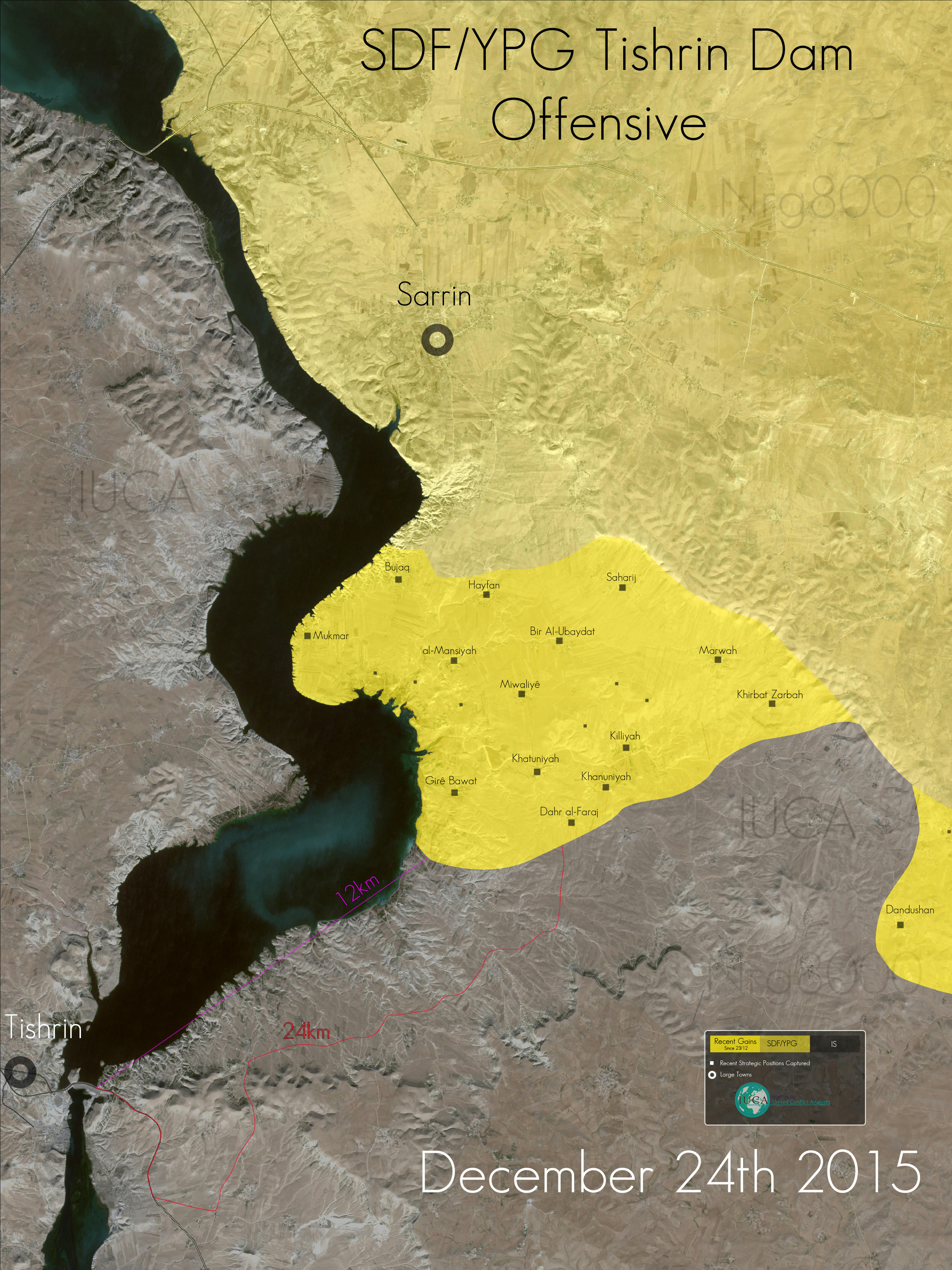
Recent SDF gains in tishrin dam area http://www.mediafire.com/convkey/8425/2bo992uvac9kwsbzg.jpg Deniz2694 ( talk) 18:33, 24 December 2015 (UTC)
 Not done This off-site picture does not have a clear and specific edit that you want to incorporate in to the module, had you had the permissions. The change can continue to be discussed in general below. —
xaosflux
Talk
17:26, 25 December 2015 (UTC)
Not done This off-site picture does not have a clear and specific edit that you want to incorporate in to the module, had you had the permissions. The change can continue to be discussed in general below. —
xaosflux
Talk
17:26, 25 December 2015 (UTC)
- Let's not even forget that we can't use maps, regardless if they're biased or not, per rules (see above talk page.)-- Damirgraffiti |☺What's Up?☺ 02:18, 26 December 2015 (UTC)
South Damascus
In AlMasdar it is reported that IS 8and maybe other groups) are leaving South Damascus for other destinations. Presumly SAA will take control of the area. Some change should be in the detailed map but I do not know exactly which ones. Paolowalter ( talk) 22:00, 24 December 2015 (UTC)
- Simultaneously 2000 ISIS and 1575 of their families left south of Damascus in agreement with government.
source
Sûriyeya (
talk)
18:10, 25 December 2015 (UTC)
- The entire area should be changed to purple (truce) for now. Once it is completely cleared of rebel/ISIL forces, it should be changed to pink to indicate Syrian Government control. LightandDark2000 ( talk) 03:57, 26 December 2015 (UTC)
Reasons for the replacement of the label "Kurds (Including Affiliates)" by "Syrian Democratic Forces (QSD)"
I'm proposing that the yellow labels on this map and similar ones at Wikipedia be changed from the ethnic designation "Kurds (Including Affiliates)" to the military force and political designation "Syrian Democratic Forces (QSD)". It violates accepted ideas of fairness to label other forces in Syria based on their political position or military identity and to label this single region based on its majority ethnic identity. This sole ethnic designation on the map also plays into the hands of both the Assad regime's divisive policies and to divisive agendas in regional and global powers. It reflects a mentality that people in the region itself have seemingly rejected (see New York Times report at http://www.nytimes.com/2015/11/29/magazine/a-dream-of-utopia-in-hell.html ), and it does not reflect the Enlightenment values of an encyclopedia. Upon the creation of the national assembly (the MSD) in Syria last week as the political arm of the QSD, a resolution was released mentioning no single ethnic identity (see http://anfenglish.com/kurdistan/final-resolution-of-the-democratic-syria-congress-released ), and the current composition of this assembly is indicative of its pluralistic nature (see http://anfenglish.com/kurdistan/executive-board-of-democratic-syria-assembly-elected ). Local, canton-level, and national-assembly level political leaders are expounding upon the pluralistic reality of their assembly and its forces in the face of great hardship and intrigue. One dramatic example is at http://www.diclehaber.com/en/news/content/view/487809 . A designation of "Kurds (Including Affiliates)" also does not reflect the complex reality on the ground that elements of the QSD can and do utilize their ethnic composition to meet tactical and strategic goals (see the careful and correct usage of all terms involving Kurds and Arabs in their proper local context at http://www.reuters.com/article/us-mideast-crisis-usa-syria-exclusive-idUSKBN0U006Y20151217 ). I haven't been able to find a map yet with the label change that I'm requesting, but I believe this is due to two facts. Insufficient time has passed for the change to sink in to mass media (The QSD is two months old, and the MSD is one week old), and the region is inaccessible to outside reporters but it does have a few local media outlets that (based on the New York Times report above) can be expected to be free and fair. With these problems, it's understandable that the designation "Kurds (Including Affiliates)" was the best choice until now. It's a safe bet that similar editorial conversations are being held elsewhere. There is no reason for Wikipedia to wait until news outlets reflect neutral reality on their maps. 73.149.16.54 ( talk) 19:46, 17 December 2015 (UTC)
I'm still against this SDF color for rebels in Raqqa province. It doesn't make any sense at all. As most people who are looking at this map consider "yellow" to represent Kurdish forces like the YPG/YPJ, and not rebels at all. I don't want to believe that 10 months of work that we invested by finding sources and sources for Raqqa province, and every village, now just goes straight into the dumbster just because some users wanted "something new". The problem is, that SDF is a coalition of groups, and not a group itself, and even thought rebels have around 15 groups inside, the YPG still makes 90% of the soldiers because they have 60 000 of them, and basically whatever happens, it will be marked as under SDF control. This is basically against the rules because by using that logic, we can remove every grey color from the map, because Al Nusra is part of the Jaish Fatah coalition, of which 80% of the groups are Rebels (IF/FSA), and whatever happens, it should go under lime control, right ? Of course not, that's why we always try to find other sources after Jaish Fateh captured something, we find out which groups did it. We don't do that for the SDF because the idea is quite the opposite.
- While this won't be a problem for Hasaka, where Rebels don't really have much presence, but the Raqqa region is full of various FSA, Arab or any other non Kurd afiliated groups. We spent 10 months to edit that province, for every village a source, somewere even marking it as under solo rebel control. Now everything is changed in 2 minutes, i don't want to believe that.
- Basically, Jaish Thuwar Raqqa and Jaish Qujaja (Arab tribes) say that they have over 10 000 members in Raqqa and that they are only participating under SDF banner in Hasaka, and not in Raqqa. This may be true because almost every village around Tell Abyad and Ein Eyes was under joint or rebel control.
- My opinion would be
- 1) Hasaka province can stay the same
- 2) Raqqa province should be changed as it was, we continue to edit that as we used to do, Rebels and YPG seperated. I mean for example what if Rebels capture Raqqa town alone, will it be marked under yellow SDF control, even if Kurds did not participate ?
DuckZz ( talk) 21:24, 17 December 2015 (UTC)
- I don't object on changing the name. and I agree on removing the grey color and switching it to green. Helmy1453 ( talk) 14:08, 18 December 2015 (UTC)
No ! You're not objective, we all hate Al Nusra but the grey color needs to stay as we need to make a distinction between them and Rebels. The same as wee need to make the distinction between Rebels and Kurdish forces (YPG/YPJ etc). That's why Raqqa province needs to go back as it was. DuckZz ( talk) 16:08, 18 December 2015 (UTC)
- "we all hate Al Nusra " If that is not the definition of Pro openion vandalizm then what is ? You hate AL-Nusra should not guide how you edit this page. you hate Al-Nusra shouldn't make you distinguish them on no basis what so ever. I agree with you the only reason AL-Nusra has a seperate color is that many admins here can't seperate thier political openion about hating a sertain faction from facts driving a control map on the ground. And when it comes to green or gray color control this map is actually childish funny. Helmy1453 ( talk) 16:42, 18 December 2015 (UTC)
No, because being objective in this way means that even thought i don't like someone, i want to write about them and I want to show them, everything according to rules. Being not objective would be if I said "I hate Nusra, and i also think we can remove the grey color". Which isn't the case. But Nusra is just an example of why we should change back Raqqa and keep editing it as it was, with either Kurdish, Rebel or Joint control. DuckZz ( talk) 23:30, 18 December 2015 (UTC)
- I disagree that the yellow icon should be renamed as 'SDF', because of the fact that in many cases it is solely the YPG conducting operations, and making the yellow icon become SDF suggests that there is a lot more Arab rebel involvement in the Kurdish region, when in reality the region is administrated almost unilaterally by local Kurdish authorities. I am sceptical that rebels would actually hold administrative control over the areas in the designated SDF-held region and therefore think that the designation of them as part of the Kurdish affiliates is justified however appreciate that other editors disagree with this: notably DuckZz. Prohibited Area ( talk) 22:46, 19 December 2015 (UTC)
I have changed my opinion on the designation of the yellow icon. Given that most reports on YPG offensives now specify them as the SDF I agree that
![]() should be changed to SDF. However I propose that it also be specified that the majority of the SDF are Kurdish, as the fact that the yellow icon originated from the Kurdish YPG should be retained in the map. Therefore:
should be changed to SDF. However I propose that it also be specified that the majority of the SDF are Kurdish, as the fact that the yellow icon originated from the Kurdish YPG should be retained in the map. Therefore:
Prohibited Area ( talk) 15:07, 26 December 2015 (UTC)
Darayya got smaller not bigger!!!
the city of Darayya has beenn made 3 times bigger than what it actually is sinnce the last Edit, East Ghouta is about half the sizee it currently is on this map and the Area south of Daraya (Big green circle with Red locations captured) is also not the reality of the situation is the Damascus map going to be made accurate, source Darayya: http://www.almasdarnews.com/article/syrian-army-advances-at-the-strategic-city-of-darayya-in-rural-damascus/ . Same with the Daraa map totally wrong and outdated the SAA have captured 90% of the city and are right beside the old Border crossing?? — Preceding unsigned comment added by 213.94.235.52 ( talk) 14:36, 23 December 2015 (UTC)
Insurgent presence in Darayya seems is a bit exaggerated probability need a correction
Here is other section about it /info/en/?search=Talk:Cities_and_towns_during_the_Syrian_Civil_War#Seems_Insurgent_.28Green.29_presence_is_too_exaggerated_in_Darayya_.28Damascus_map.29 — Preceding unsigned comment added by 190.204.159.103 ( talk) 02:00, 24 December 2015 (UTC)
According to Al-Jazeera article here Moadamiya is surrounded by SAA, therefor areas between Daraya and Moadamiya can´t be under opposition control. According to the article it does neither seems like Moadamiya should be under peace (purple). Rhocagil ( talk) 16:17, 27 December 2015 (UTC)
Tishrin Dam
[ [3]] Tishrin Dam reportedly captured by SDF per pro-Kurdish source. Does anyone have any reliable or neutral sources on the offensive that we can use to edit the module? Prohibited Area ( talk) 11:06, 26 December 2015 (UTC)
- SDF captured Tishrin Dam and 8 other villages “Beer Shamal, Beer Bakar, Abdakly, Tal Banat, Khashkash Saghir, Khashkash Kabir, Weisy and Muwailah” after besieging the dam.
source
Sûriyeya (
talk)
15:45, 26 December 2015 (UTC)
- Before capturing the Tishreen Dam, the Syrian Democratic Forces and the YPG captured several villages: Al-Shalash, Al-Khabar, Bur Shmaal, Bur Bakkar, ‘Abd-Kileye, Tal Al-Binat, Khashkash Al-Sagheer, Khashkash Al-Kabeer, and Al-Waysi near the vast Euphrates River. U.S. backed Syrian Democratic Forces capture the Tishreen Dam in western Raqqa Sûriyeya ( talk) 11:41, 27 December 2015 (UTC)
- Is Shalash a typo for Shallal? Roboskiye ( talk) 21:27, 27 December 2015 (UTC)
Manbij/Al Bab/Jarablus dot sizes
Recently Al Bab city dot was increased, I am not sure of whether it goes along with the stablished city sizes but it's misleading when looking at the map that Manbij, a city with almost double population and size than al Bab, is shown as an smaller town. Same goes for Jarablus which is shown as a town the same size of Manbij despite being actually smaller even than Kobani. Shouldnt there be a change to reflect those facts?
Source: http://wikimapia.org/#lang=en&lat=36.463815&lon=37.787476&z=11&m=b&permpoly=1655911
190.67.227.91 ( talk) 19:19, 28 December 2015 (UTC)
- We put the size for dot on based size of population of town or village:
- Under 5,000 is size 6
- 5000 to 19,999 is size 8
- 20,000 to 49,999 is size 10
- 50,000 to 99,999 is size 12
- Above 100,000 is size 14 these figures are shown here here Module:Syrian Civil War detailed map:Dot size for cities & towns.
- And I proved sources which confirm the size of population for some towns for which I'm changed size of dots. Sûriyeya ( talk) 10:13, 29 December 2015 (UTC)
Jarablus has 11'000 inhabitants so it should be size 8 and not 10 as it is now and Al-Bab has 63'000 inhabitants so it should be size 12 and not 14. --
Cavendish21 (
talk)
10:35, 29 December 2015 (UTC)
-
Cavendish21 Population of Al Bab 130,000.
here
here and Tadef (population:34,700)
here
here
Sûriyeya (
talk)
15:01, 29 December 2015 (UTC)
- Population of Jarablus (25,000). here here Sûriyeya ( talk) 15:04, 29 December 2015 (UTC)
Sûriyeya Ok thanks for the links! Then it's the Wikipedia page of these two cities which should be updated. Cavendish21 ( talk) 16:25, 29 December 2015 (UTC)
Why are we using mapcarta and arrivedin links who don't provide any reliable sources and even end up as circular sources in the case of arrivedin (all references lead back to wikipedia)? Only reliable data is the 2004 census which is used in this page:
/info/en/?search=List_of_cities_in_Syria
It shows Manbij as a city with almost 100000 inhabitans and al Bab as a city with 60000, which fits the sizes of both cities in satellite photos.
190.67.227.91 ( talk) 17:32, 29 December 2015 (UTC)
Semi-protected edit request on 29 December 2015
This
edit request to
Module:Syrian Civil War detailed map has been answered. Set the |answered= or |ans= parameter to no to reactivate your request. |
Mahin is under Syrian control
88.119.205.90 ( talk) 14:49, 29 December 2015 (UTC)
- SOHR said that the Mahin,Huwwarin and Hadath SAA-held. SOHR Sûriyeya ( talk) 17:07, 29 December 2015 (UTC)
- Yes, why is it not changed to yellow? Waiting for SOHR-confirmation? There were two articles on 29th. First one only in English speaking about clashes in Mahin: http://www.syriahr.com/en/?p=41612, but after it an arabic article spoke about SAA taking most of the town: http://www.syriahr.com/?p=148385 Mughira1395 ( talk) 01:19, 30 December 2015 (UTC)
Ok... has just been changed! :-) Mughira1395 ( talk) 01:21, 30 December 2015 (UTC)
- Mahin, Hadath and Huwwareen taken SAA.
here
here
here SAA advance toward the town of Qaryatayn.
source
Sûriyeya (
talk)
08:53, 30 December 2015 (UTC)
- Yea, it's very confirmed now. Why is it still black? MesmerMe ( talk) 09:47, 30 December 2015 (UTC)
- I don't understand the maps anymore: Change was done on this map (Syria + Iraq): /info/en/?search=Template:Syrian_and_Iraqi_insurgency_detailed_map, but not on the Syrian map (of this talk-site): /info/en/?search=Cities_and_towns_during_the_Syrian_Civil_War Mughira1395 ( talk) 14:03, 30 December 2015 (UTC)
Hadath and Huwareen
New report from SOHR said that the SAA advance near the town Mahin and restoring of control over village of Hadath. SOHR SOHR Sûriyeya ( talk) 08:06, 25 December 2015 (UTC)
- SAA retake Huwwarin from ISIS. source Sûriyeya ( talk) 18:52, 27 December 2015 (UTC)
- SAA Retake Maheen from ISIS. Al Masdar News reported. 29 December 2015 — Preceding unsigned comment added by 195.142.178.68 ( talk) 15:00, 30 December 2015 (UTC)
- Please update Maheen color black to red — Preceding unsigned comment added by 195.142.178.68 ( talk) 15:04, 30 December 2015 (UTC)
Turkish border: Qalah Mazra'ah, Harjala, Dahla (Yarubiya)
ISIS takes control over 5 towns on turkish border, but only 3 are named: http://www.almasdarnews.com/article/isis-captures-3-villages-from-the-turkish-backed-islamists-in-northern-aleppo/ and http://www.syriahr.com/?p=148572 Mughira1395 ( talk) 14:20, 30 December 2015 (UTC)
- Por-rebel source also claim that ISIS retake the villages Qarah Kubri, Dudiyan and Qazal Mazra‘ah(Ghazal). source and SOHR said ISIS take Harjala, Dahla. source FoXrEpOrTeR ( talk) 15:16, 30 December 2015 (UTC)
mahin
SAA Captured Mahin
http://www.rfi.fr/moyen-orient/20151230-syrie-feroces-combats-autour-cheikh-meskin — Preceding unsigned comment added by 2.4.228.84 ( talk) 18:41, 30 December 2015 (UTC)
Harjala to be black
Whoever changed the towns on the turkish border to black: Harjala has also to be changed (see postings above). Mughira1395 ( talk) 21:29, 30 December 2015 (UTC)
Latakia: Toros and Bayt Ablaq
The town Toros and Bayt Ablaq are marked red since a long time but all maps (pro-government and pro-opp) reports them as rebels' hands. The front line appears to be a little more west. I propose to change them to green. Paolowalter ( talk) 08:55, 30 December 2015 (UTC)
- Paolowalter Probably you are right! But according to the rule of #2"Copying from maps is strictly prohibited" we can't use data from maps. Only for indicat the location towns, villages and other points but not for chage of them status. Sûriyeya ( talk) 11:14, 30 December 2015 (UTC)
- I know the rules. But it has always been possible make changes of locations that felt behind the lines even if they are not quoted as taken by the opposite party. That clearly is the case. We are short of info since a long time because the from has been quite for a while. I still insist that they should be changed. On the other hand no map show them as SAA held, and that should be taken into account. Paolowalter ( talk) 22:00, 30 December 2015 (UTC)
Sheikh Maskin
SAA captured the city just now. Sources: https://twitter.com/Ald_Aba/status/682175914965336065 https://twitter.com/IvanSidorenko1/status/682173746682171392 https://twitter.com/miladvisor/status/682175213186973697 We probably need to waith for a non-Twitter source, but it seems to be fairly confirmed. MesmerMe ( talk) 12:43, 30 December 2015 (UTC)
- Source: http://www.almasdarnews.com/article/22353/ But there seems to be some minor fighting in the outskirts of the city, and I am therefore hesitant to already change it to SAA held. MesmerMe ( talk) 12:53, 30 December 2015 (UTC)
The anti syrian observatory for beheaders rights must confirmed it! — Preceding unsigned comment added by 190.204.159.103 ( talk) 13:12, 30 December 2015 (UTC)
- Earlier other reliable sources also said that the SAA take most part of the city. here here here Sûriyeya ( talk) 14:50, 30 December 2015 (UTC)
- Pro opp. source Syrian Rebellion Observatory also said that the Most of Sheikh_Miskin has fallen. SAA retake most of the city. source Sûriyeya ( talk) 18:19, 30 December 2015 (UTC)
Definitely not 100% SAA held, western part of the town is fsa/nusra. Totholio ( talk) 18:40, 30 December 2015 (UTC)
- Contradictory info, some part (SW) could still be under rebels' control. Paolowalter ( talk) 22:00, 30 December 2015 (UTC)
End year summary
What were the biggest changes during this year? What were the suprises ? What do you predict for the next year? Another indescisive one or some kind of political solution can be reached ? Oroszka ( talk) 14:46, 30 December 2015 (UTC)
Russian Intervention and Rebel takeover of Idlib,ISIS seizure of Palmyra,Major YPG gains. Alhanuty ( talk) 23:00, 30 December 2015 (UTC)
Massive counter-offensive of ISIS in Raqqa
Opp. and kurdish sources confirm that the ISIS launched the massive counter-offensive in Raqqa and retake Ayn Issa, Brigade 93, Fatisa, Shergirat and some other points. source source source source source source Later, the Kurdish forces regain Shergirat from ISIS. source Sûriyeya ( talk) 17:46, 30 December 2015 (UTC)
- Opposition sources and som Kurdish said that the ISIS recaptured Ayn Issa, Brigade 93, Fatisa, Shergirat
source
source
source
source
source
source and reliable source confirmed that the ISIS captured Ayn Issa after clashes with SDF.
source Later opp.source confirmed that the with support of International Coalition, the Kurdish forces regain the village of Shergirat from ISIS.
source And
LightandDark2000 in the rule #2 clearly states that:Copying from maps is strictly prohibited. Maps from mainstream media are approximate and therefore unreliable for any edit. Maps from amateur sources are below the standards of Wikipedia for any edit. They violate WP:RS and
WP:CIRCULAR.
WP:RS: “Anyone can create a personal web page or publish their own book, and also claim to be an expert in a certain field. For that reason, self-published media, such as books, patents, newsletters, personal websites, open wikis, personal or group blogs, Internet forum postings, and tweets, are largely not acceptable as sources.” Source: Wikipedia:Verifiability#Self-published_sources
WP:CIRCULAR: “Do not use websites that mirror Wikipedia content or publications that rely on material from Wikipedia as sources.” - Also in rule #3 clear said that:WP:POV pushing and intentional misinterpretation of sources will not be tolerated. If you are not sure about what the source is saying (or its reliability), post it on the talk page first so that it would be discussed. But you make changes on map on based the sources that dont support your actions. Sûriyeya ( talk) 10:02, 31 December 2015 (UTC)
- Hawarnews says that Ayn Issa town was cleared from ISIS. Source ... And no any Kurdish news sites does not says that the Ayn Issa seized by ISIS. Bruskom talk to me 11:17, 31 December 2015 (UTC)
- Ayn Issa was turned yellow without waiting the outcome of the discussion. Hawarnews is in arabic and the automatic translation is far from clear. AlMasdar reports the town captured by IS. In presence of contradictory or ambigouos sources we should out it contested. Paolowalter ( talk) 13:20, 31 December 2015 (UTC)
- Bruskom PaolowalterAs said the opposition source only SDF(mainly YPG) clashes against ISIS in Ayn Issa and its surroundings. source And that the heavy clashes still ongoing in Ayn_Isa as some ISIS terrorists are still trapped in the town after their failed offensive against SDF. Some ISIS terrorists are inside few buildings in S-W of the town Ayn_Issa anf SDF are trying to secure the area today. source source Sûriyeya ( talk) 15:12, 31 December 2015 (UTC)
- All sources are from twitter and heavily biased and in any case reports fighting in the city. As far as reliable sources are concerned the town is contested. Paolowalter ( talk) 17:15, 31 December 2015 (UTC)
Mansura
According to pro-gov and SOHRMansura is rebel held not contested. Lists129 ( talk) 02:50, 1 January 2016 (UTC)
- Lists129 I put village Mansura to green on based data from SOHR and pro gov. source. Sûriyeya ( talk) 14:02, 1 January 2016 (UTC)
Reasons for the replacement of the label "Opposition" by "Riyadh Opposition"
I'm proposing that the green labels on this map and similar ones at Wikipedia be changed from the overly broad and ambiguous designation "Opposition" to the specific and factually correct designation "Riyadh Opposition". UN Security Council resolution 2254 endorsed a road map for a peace process in Syria between the government and opposition members with no further specification of which groups were or were not to be included in the opposition (See http://www.un.org/press/en/2015/sc12171.doc.htm ). The UN Secretary-General's welcome and the statements of John Kerry, Secretary of State of the US, both described the Riyadh conference as containing a broad spectrum/cross-section of opposition groups without describing the Riyadh Opposition as "the opposition." Sergey Lavrov of the Russian Federation explicitly negated the idea that the Riyadh Opposition was the opposition when he pointed out that "The Vienna format was the only one that brought together all influential players to find a sustainable and fair settlement through talks with the government and the 'whole span' of the opposition." Basah Ja'afari of Syria pointed out the importance of not "repeating failed assumptions that had caused destruction in more than one country." The 'whole span' of the opposition referred to by Lavrov would include the opposition that met in Derik to form the Syrian Democratic Council (MSD) as the political wing of the Syrian Democratic Forces (QSD). As noted by ARA News at https://www.youtube.com/watch?v=V7AwRYHp1m8 , "Both conferences [Riyadh and Derik] aimed at unifying the ranks of the dispersed Syrian opposition." In addition to this proposal, a neutral map would require the correct designation of areas affiliated with both oppositions. Therefore, I am withdrawing my previous proposal (which was not accepted) to replaced the yellow label "Kurds (Including Affiliates)" by "Syrian Democratic Forces (QSD)." This label would have been apt from December 10 (the date of the formation of the MSD) to December 18 (the date of the passage of the UN Resolution). Instead, I am proposing that yellow areas be labeled "Derik Opposition." These yellow "Derik Opposition" labels and green "Riyadh Opposition" labels would provide proper and neutral contrast to the international reader between land held by opposition groups associated with the Derik and Riyadh conferences until their possible consolidation into a single opposition or some other possible outcome in preparation for peace talks currently planned for January 25, 2016 in Geneva. Additional material that may assist editors with this decision is at http://www.ipsnews.net/2015/12/analysis-kurdish-led-peace-conference-is-best-hope-for-syria/ , http://www.madaniya.info/2015/12/21/haytham-manna-la-resolution-de-l-onu-etape-essentielle-pour-une-solution-politique/ , and http://aranews.org/2015/12/%D9%87%D9%8A%D8%A6%D8%A9-%D8%A7%D9%84%D8%AA%D9%86%D8%B3%D9%8A%D9%82-%D8%AA%D8%AF%D8%A7%D9%81%D8%B9-%D9%81%D9%8A-%D8%A8%D9%8A%D8%A7%D9%86-%D8%B9%D9%86-%D9%88%D8%AD%D8%AF%D8%A7%D8%AA/ . 73.149.16.54 ( talk) 07:58, 27 December 2015 (UTC)
- Opposing this. "Opposition," groups are any groups dedicated to, and fighting for, the overthrow of the Syrian regime. Who they are, and what their ideologies may be, are irrelevant. "Opposition," includes all forces, with the exception of al-Nusra and the Islamic State, because of their constant fighting with other opposition groups, necessitating the distinction. Calling the opposition the, "Riyadh Opposition," would be too broad. Not all groups, who are not IS or al-Nusra, were represented at the conference. If you want to call them the, "Riyadh Opposition," we would need to take the time to find out what towns or areas are held by what groups, and label them accordingly, so this, "Riyadh Opposition," does not include any groups that did not have a chance to make their voices head at the Riyadh Conference. Calling them the, "Riyadh Opposition," would also cause a flame war, here, as it could be misconstrued as bias towards or against that side in this conflict. To save people headaches, and to make sure this map remains objective, I'm staunchly against any chance to the opposition forces on this map being renamed. DaJesuZ ( talk) 09:37, 28 December 2015 (UTC)
- I also oppose this. Riyadh does not control the opposition, merely supports it. By this logic, the Opposition could be technically classified as: Riyadh, Ankara or Doha Opposition, all have the same level of support for the rebels. Prohibited Area ( talk) 21:25, 28 December 2015 (UTC)
- I oppose this. We should not hair splitting the oppositions affiliations based on political statement that have little to do with what happens on ground. I do not like even the distinction green/gray. In practice they are mixed throughout most of the country. Only SDF, that is YPG plus other smaller groups have their own clear autonomous status.
Paolowalter (
talk)
09:05, 30 December 2015 (UTC)
- Paolowalter I agree with you gey/green is bad bad idea in this map. I hope someday we can agree to flip all grey to green, I will give you one example modto of south west Idlib is controlled by Jund Al-Aqsa Saraqib for example which is a group more rdaical than AL-Nusra and have good relationship with Islamic sate, they even left Jaish Alfath for that reason (refusing to fight Islamic State) . Still Saraqib is half green half grey which is tatally wrong, but any way if you try to distinguish groups that are fully coexisting you will be in complete disorder which is the case here Helmy1453 ( talk) 16:19, 2 January 2016 (UTC)
E Hama
SAA advance in E Hama. -- Hogg 22 ( talk) 17:37, 31 December 2015 (UTC)
- SAA take 7 villages. source Sûriyeya ( talk) 21:17, 31 December 2015 (UTC)
- SOHR also comfirmed that the SAA advance south-east of Hama and captured villages. here here Sûriyeya ( talk) 13:46, 1 January 2016 (UTC)
- Additional progress of SAA AlMasdar even if the text is quite confused and talk of Damascus countryside. The location taken by SAA are Zour Al-Siwas, Al-Qantara and Al-Karmish near Al-Salamiyah. I cannor locate them, is anybody able? Paolowalter ( talk) 12:25, 2 January 2016 (UTC)
- Source said the SAA captured the villages of Zour Al-Siwas, Al-Qantara (not the province),and Al-Karmish near the strategic town of Al-Salamiyah in southeastern Hama. here Also SOHR said that the SAA retake village of Ramliyah and that rebels shelled SAA-held villages of Ramliyah, Al Kafat and Tall Dara. here here here Sûriyeya ( talk) 18:35, 2 January 2016 (UTC)
SOHR states than Qubbat al Kurdi is being shelld by SAA. It is likely controlled by rebels. Paolowalter ( talk) 19:09, 2 January 2016 (UTC)
-
Paolowalter Maybe it is the incorrect report because this report on Arabic
here was removed.
here
Sûriyeya (
talk)
19:28, 2 January 2016 (UTC)
- Opp. source also confirmed that the SAA captured the village of Ramliyah. here Sûriyeya ( talk) 19:41, 2 January 2016 (UTC)
Exclude Kweires from Aleppo details map
Maybe its better to exclude kweires airbase from the Aleppo detail map and handle it in the main map 85.15.42.246 ( talk) 06:55, 28 December 2015 (UTC)
- Absolutely. But, in order to avoid long discussions with users outside our group, we could just make a cropped version of the image and use it here, and leave original image as it is. --
Hogg 22 (
talk)
06:16, 30 December 2015 (UTC)
- Yes, perhaps this option would be best. LightandDark2000 ( talk) 20:45, 30 December 2015 (UTC)
- Absolutely, I think that whoever is able should do it restricting the detailed map to the city proper.
Paolowalter (
talk)
08:57, 30 December 2015 (UTC)
- The full map should be included, because the exact frontline there can be somewhat confusing at times, and the map better explains the exact ground situation better than any number of dots or cluttered locations could. Without the full map, I actually feel blind in that area; I could imagine the frontline situation east of Aleppo city in a number of different manners, but I doubt that any one of them would be as accurate as the real situation on the ground. I believe that the same could be said for most of the people who view the module, especially newcomers or those who infrequently visit the page. The module looks much better with the full map inscribed; it just needs some new updates in the area.
LightandDark2000 (
talk)
20:34, 30 December 2015 (UTC)
- Shouldn't there be a strong consensus for such a major change? If people decided to keep making such massive shifts without actual consensus, then no one would be able to have any say in the changes suggested, and the map would soon become confusing. LightandDark2000 ( talk) 20:45, 30 December 2015 (UTC)
- The full map should be included, because the exact frontline there can be somewhat confusing at times, and the map better explains the exact ground situation better than any number of dots or cluttered locations could. Without the full map, I actually feel blind in that area; I could imagine the frontline situation east of Aleppo city in a number of different manners, but I doubt that any one of them would be as accurate as the real situation on the ground. I believe that the same could be said for most of the people who view the module, especially newcomers or those who infrequently visit the page. The module looks much better with the full map inscribed; it just needs some new updates in the area.
LightandDark2000 (
talk)
20:34, 30 December 2015 (UTC)
If the detailed map blocks edits of this map, it should be reduced, of course - it is ofted delayed and approximate. However, I'd propose to put the color points over the detailed map as well - it would be the better solution, as all the detailed maps include areas outside the respective large cities, and cover small settlements that should be specified on this map, in my opinion, no matter if they are over a detailed map or not. Dr Bug (Vladimir V. Medeyko) 09:20, 3 January 2016 (UTC)
Unjustified edit & childish reverting
Paolowalter why are you keep making an unsjtified edit and childish reverting??? Stop this,there are no reliable sources which can confirm this contradictory edit of your's. Lists129 ( talk) 00:33, 2 January 2016 (UTC)
- My edit are fully justified because you changed the status of SYSACCO plant without source. It has been red for a while and no source has claimed it changed status. Rather than offending, provide sources.
Paolowalter (
talk)
11:31, 2 January 2016 (UTC)
- Paolowalter I provided sources for this change but I can say the same for you're only source was your words let me qoute "SYSACCO plant changed to IS held without source.It has been red for a while" so it is an unjustified edit,it doesn't matter how long it was red on the map but who controls it that's the point and no reliable source was provided that this plant is SAA held it's even immpossible to be SAA held without capturing the 2 villages nearby and the production facility.if i offended you i apologize. Lists129 ( talk) 17:22, 2 January 2016 (UTC)
- On the detiled map Aleppo tha are from the base to the plant is red since 15 Nov 2015. The change was done by MrPenguin20 on reliable source but I cannot remind which ones. Also [4] reports this area (including the two villages you mention under SAA control). Paolowalter ( talk) 17:47, 2 January 2016 (UTC)
-
Paolowalter
Lists129 For now we are do not have the specific data(but not only the maps) which can confirm who controls SYSACCO Chemical Plant. So that I see best solution removed this plant or provide specific data about status of this plant(SAA-held or ISIS-held).
Sûriyeya (
talk)
18:11, 2 January 2016 (UTC)
-
Paolowalter how can you not remember the source but the editor who made the change?? Also do you have any realiable source that can confrim that this area are SAA held dont show me a map based on wikipedia made by wiki editors.
Lists129 (
talk)
18:19, 2 January 2016 (UTC)
- Here's the source that Paolowalter most probably mentioned above: "Sisako is targetted by SAA and its allies" [5] (13.11), "SAA imposed full control over Sisako" [6] 16.11, and "they are still combatting" [7] (18.11). Dr Bug (Vladimir V. Medeyko) 08:52, 3 January 2016 (UTC)
-
Paolowalter how can you not remember the source but the editor who made the change?? Also do you have any realiable source that can confrim that this area are SAA held dont show me a map based on wikipedia made by wiki editors.
Lists129 (
talk)
18:19, 2 January 2016 (UTC)
- Lists129 Paolowalter Dr Bug (Vladimir V. Medeyko) According to the data from reliable source (but not from the unreliable maps) the SYSACCO Chemical Factory of contested between SAA and ISIS after SAA advance on 4.5km along the Aleppo-Raqqa Highway. [8] [9] [10] Kuweires offensive (September–November 2015) Firstly we need remove villages Al-Jaberiyah, Kuweires Gharbi and Production Facility which are was add on map without any sources. And secondly we must marked the SYSACCO Chemical Factory as contested or remove because we not have data which confirm that Factory still ISIS-held or they now SAA-held. Sûriyeya ( talk) 11:29, 3 January 2016 (UTC)
![[4]](/info/en/?search=Kuweires_offensive_%28September%E2%80%93November_2015%29#/media/File:Aleppo_Offensives_2015.svg)
I reread all the sources above based on which the detailed map was updated. They show clearly that the front line runs at the SYSACCO plant. The conquer of SYSACCO plant was stated clearly (followed by statements about clashing 'at' the plant). This information leads to the conclusion taht SAA control west of the airport till SYSACCO plant along th eroad to Aleppo and the black points hould go red (as theay has been in the detailed map since a while). The plant is likely red but it is on the front line, a black semicircle is fine. Bottom line: we should simply reproduce the status that used to be on the map before the removal without modification. Paolowalter ( talk) 13:36, 3 January 2016 (UTC)
- Paolowalter I agree with you because your arguments it very convincing and their confirms data from the reliable source. Lets do this! Sûriyeya ( talk) 15:36, 3 January 2016 (UTC)
@ Sûriyeya: Al-Jaberiyah, Kuweires Gharbi and Production Facility were always Isis held all that area was Isis held until Kweris Offensive no source said that they were captured if these villages were captured then AL-Masdar 100% would confrim it. Lists129 ( talk) 18:28, 3 January 2016 (UTC)
- Source said that the during the offensive SAA advance on 4.5km along the Aleppo-Raqqa Highway and seizing the chemical production facility after an intense series of firefights with the ISIS and that later SAA captured SYSACOO Chemical Factory. [11] [12] [13] Ok I Agree that probably Kuweires Gharbi still ISIS-held but village Al-Jaberiyah located on highway where SAA advance and take SYSACOO Factory. But SAA can't advance toward SYSACCO Factory if previously they not take Al-Jaberiyah. Also I found data from anti-SAA source for 12 November where was indicated that SAA captured the Thermal Station near the Kuweires Airport. source probably here. Paolowalter Lists129 Guys we need accept a compromise solution. Honestly , I'm want do everything in the according with rules and, therefore I want find a compromise solution. So that I waiting for your suggestions. Sûriyeya ( talk) 19:10, 3 January 2016 (UTC)
-
Sûriyeya My suggestion is:Remove this 2 villages the plant and the production facility from the map until a relaible source can confirm 100% who is in controll.
Lists129 (
talk)
23:15, 3 January 2016 (UTC)
- I changed Al-Jaberiyah ( wikimapia) to IS based on pro-gov source (Dec 17th 2015). I carefully read all news and I didn't find any mention of this village before or after this sana.sy article. Frankly, all this talk about SAA controling areas wesdt of Kweires by pro-gov sources were extremenly fuzzy and contradictory, compared to, for example, clear situation N of Kweires. I would prefer to see it black. SAA might have captured it once, for short time, and then noone reported about retreat. -- Hogg 22 ( talk) 09:29, 4 January 2016 (UTC)
-
Hogg 22 Thank's for help! I hope together we will solve this issue.
Sûriyeya (
talk)
11:19, 4 January 2016 (UTC)
- One more think. I just found this dispute over Dakwanah. This village is under IS control, based on Al-Masdar article from Dec 7 which says: "ISIS has been able to launch counter-offensives on certain villages; notably Jabboul, Umm al-Mara, Halabiyah and Dakwanah. The latter 3 were succesfully recaptured". -- Hogg 22 ( talk) 13:59, 4 January 2016 (UTC)
Yarmouk Martyr's Brigade
YMB has renounced ties to ISIL [ [14]] hence should we not change the areas held by the group to green? Prohibited Area ( talk) 13:38, 1 January 2016 (UTC)
- But on their statemant we can see flag of Islamic State. Also they not say that they loyal to rebels Southern Front but many sources confirm that they fight against rebels and Al Nusra.
Sûriyeya (
talk)
13:52, 1 January 2016 (UTC)
- It's not they first statement form this faction that denies ties with Isis,they also declare it's independent and changing back to green it's not a good idea as they still are clashing with Al-Nusra so we should wait for more sources about this case.
Lists129 (
talk)
14:25, 1 January 2016 (UTC)
- Sûriyeya Lists129 The Flag of Tawheed is not unique to ISIL, other groups such as Al Qaeda have used it in the past. If they have repeatedly renounced affiliation to ISIL then we shouldn't be labelling them as such. Al-Nusra also fights against other opposition groups and multiple groups work independently from each other. Therefore keeping them as under ISIL is unjustified. Prohibited Area ( talk) 16:17, 1 January 2016 (UTC)
- It's not they first statement form this faction that denies ties with Isis,they also declare it's independent and changing back to green it's not a good idea as they still are clashing with Al-Nusra so we should wait for more sources about this case.
Lists129 (
talk)
14:25, 1 January 2016 (UTC)
- Prohibited Area I know about this flag that other factions are using it,I am saying that this faction is clashing with Al-Nusra and changing it to green it means that they are on the same side with the rebels but they statement say the opposite and label themself Independent so my suggestion is to propose a new ICON(color) for them. Lists129 ( talk) 16:48, 1 January 2016 (UTC)
- If they, Yarmouk, states, on their own website, that they are not affiliated with the Islamic State, they should not be labeled as such. I'm with Prohibited Area in that a group simply using the flag of Tahweed does not mean they are, in any way, affiliated with IS, other groups do it as well, two that immediately come to mind would be Boko Haram and al-Shabab (I'm using Boko Haram because they used they flag long before any hint at being aligned with, or a part of, IS). This group does, however, have constant clashes with the Southern From and al-Nusra, so it may need it's own colour, though, we already have several colours in use, so that could just make things more confusing, though, other groups, such as Ahrar ash-Sham, do clash with other Opposition groups, so integrating them with the green areas of the map wouldn't be a bad idea, regardless, they should not be labeled as being part of the Islamic State. DaJesuZ ( talk) 18:34, 1 January 2016 (UTC)
Nothing should be changed. Reliable reporter Aymen Tamimi already showed in various articles how ISIS propaganda works. This same group said that they don't see any difference between them and ISIS and that they wont fight against them. They see that ISIS is the true ideology in Syria, according to their facebook articles. Basically if they don't fight against ISIS (even say they wouldn't), but fight against Nusra, FSA, IF and every other rebel groups, then we can assume that their only using the "Im not ISIS" propaganda because of the civilians that live under their control. DuckZz ( talk) 18:45, 1 January 2016 (UTC)
- I'm opposed to finding a new colour icon for YMB, although I think it would be better if we had different colours for the Salafist and Moderate Islamist Rebels, I appreciate this would be a difficult task and hence think that settling for a singular colour to represent all rebel opposition groups is appropriate. YMB is a rebel opposition group, it itself has stated it is not a part of IS therefore it shouldn't be designated as such. Therefore it has to be placed under the green colour of the Syrian Opposition.
DuckZz do you have a source that can undoubtedly prove that YMB is a part of ISIL?
Lists129 Inter-rebel fighting is common amongst the rebel forces, YMB wouldn't be an exception if we did place it under the designation of Syrian Opposition forces; the fact that it's independent of other rebel groups also isn't an exception in the conflict as there are many other rebel groups which act independently which we have labelled as being a part of the Syrian Opposition. We should not have double standards and hence YMB must become part of the Syrian Opposition green colour.
Prohibited Area (
talk)
19:17, 1 January 2016 (UTC)
- Prohibited Area but they are not in the umbrella of any faction like other rebel and islamists faction are and also they are completly Independent and they opponents aren't just Al-Nusra,SAA but the S.Opposition faction to so we cant just make it part of the S.Opposition. Lists129 ( talk) 18:40, 2 January 2016 (UTC)
- Why not make it part of the Southern Front of the FSA? Are they part of the FSA? No, but we do group many other organizations in with the main opposition groups. Let's look at Jaysh al-Islam, for example: Their ideology and actions do not vary very much from the Islamic State's, but we do not group them in with IS, and instead put them in with the mainstream opposition. We do this for convenience, and because they work towards the same goal as the FSA; the overthrow of Bashar al-Assad. I don't see the issue with grouping them in with the SF. DaJesuZ ( talk) 21:20, 1 January 2016 (UTC)
- And have many confirmation that they allies ISIS. But if we follow your logic
DaJesuZ, then we can also equate and ISIS to rebels because they also fighting against the Assad. Need a more weighty reasons to change.
Sûriyeya (
talk)
22:33, 1 January 2016 (UTC)
- al-Nusra, Sûriyeya, has aided the Islamic State on several occasions, with some members, with one particular instance in Dier ez-Zoir (don't have a link, as it was AGES ago), leaving the organization and defecting to IS. The reason we separate the more mainstream rebels from IS and al-Nusra is because of the constant fighting, and lack of agreement between the organizations. All three are dedicated to Bashar's ouster, however, all have stated that they have, and are not willing to compromise with others about, their ideology and intentions for what they want Syria to be, once this war is over. Another reason we cannot group IS in with the more moderate rebels is because of the fact that IS does not have one particular group it is at war with, it has several, which it has declared, which include, but are not limited to, the Syrian regime, the Iraqi regime, the YPG, Iraqi Kurdistan, the more mainstream rebels in Syria, and all others who do not adhere to their interpretation of Sharia. SOME kind of action needs to be taken, in regard to this. Grouping them in with IS is a massive POV edit by the page. DaJesuZ ( talk) 01:36, 2 January 2016 (UTC)
- DaJesuZ You talk a lot but you not provide any facts confirming that the group should be joined with rebel forces from the Southern front. Thay only said that they independent but their actions refute this because when rebels from Southern Front try advance against Army the units from Yarmouk Martyr's Brigade attacked on rebels from another side. The reliable reporter Aymen Tamimi already showed in various articles how ISIS propaganda works. This same group said that they don't see any difference between them and ISIS and that they wont fight against them. They see that ISIS is the true ideology in Syria, according to their facebook articles. Basically if they don't fight against ISIS (even say they wouldn't), but fight against Nusra, FSA, IF and every other rebel groups, then we can assume that their only using the "Im not ISIS" propaganda because of the civilians that live under their control. Sûriyeya ( talk) 09:21, 2 January 2016 (UTC)
Alright then, Sûriyeya, would you oppose the joining of Jaysh al-Fatah with the Islamic State? What about Jabhat al-Nusra, Jaysh al-Islam, or Ahrar ash-Sham? All of these groups share, entirely, the SAME ideology as IS. My point is that there are MANY Islamist organizations in this war that we group in with the (green) mainstream opposition, and until about a year ago, Jabhat al-Nusra was grouped in with them as well. You have two options: Go by a double standard, and list them as being part of them Islamic State, or follow the rules of the page, and quit saying that you believe they are a part of IS. They aren't, and until you provide something that actually states they are, which you have not done, and only provided something saying that they believed they were a group devoted to IS (this is their POV, which edits cannot be based on). I'm going to change their colour to lime in the next few hours, whenever our ISP fixes our connection. If you change them back, Sûriyeya, you're being reported for going by a double standard, and POV editing. DaJesuZ ( talk) 18:48, 2 January 2016 (UTC)
-
DaJesuZ Firstly as said the
Lists129 It's not they first statement form this faction that denies ties with Isis,they also declare it's independent and changing back to green it's not a good idea as they still are clashing with Al-Nusra so we should wait for more sources about this case. Also as said
DuckZz Nothing should be changed. Reliable reporter
Aymen Tamimi already showed in various articles how ISIS propaganda works. This same group said that they don't see any difference between them and ISIS and that they wont fight against them. They see that ISIS is the true ideology in Syria, according to their facebook articles. Basically if they don't fight against ISIS (even say they wouldn't), but fight against Nusra, FSA, IF and every other rebel groups, then we can assume that their only using the "Im not ISIS" propaganda because of the civilians that live under their control. Also on their statemant we can see flag of Islamic State. So that many source confirm that they allies of ISIS. But you are just provide the statement the accuracy of which is still not confirmed in which claim that Yarmouk Martyr's Brigade independent from ISIS. But they fight against rebels from Southern front. So we can do any actions only on based reliable data which said that Yarmouk Martyr's Brigade not allies of ISIS but allies of rebels or on based collective consensus. But you can't do such important decisions of alone.
Sûriyeya (
talk)
19:09, 2 January 2016 (UTC)
- DaJesuZ Yarmouk Martyrs Brigade it is a part of ISIS. see this Sûriyeya ( talk) 19:14, 2 January 2016 (UTC)
Your repetitiveness isn't going to be entertained. I'm changing the icons. Also, provide something other than Wikipedia source to back up something on Wikipedia. Nice circular logic, bro. DaJesuZ ( talk) 20:17, 2 January 2016 (UTC)
- DaJesuZ Prohibited Area Lists129 New confirmation that the Yarmouk Martyr's Brigade it is a allies of ISIS. Today SOHR clear said that the clashes renewed between Jabhat Al-Nusra (al-Qaeda in Levant) and the rebel and Islamic factions against Suhada’a al-Yarmouk Brigade who swore allegiance to the “Islamic State” in the vicinity of Saham al-Jawlan dam area in the western countryside of Daraa. here Sûriyeya ( talk) 09:50, 3 January 2016 (UTC)
I think YMB should be labeled black. However we maybe should add an explanation into the legend, that all factons colors include their close allies as well. Dr Bug (Vladimir V. Medeyko) 10:12, 3 January 2016 (UTC)
- I disagree that we should edit the legend. However I think we should maintain YMB under the current designation as ISIL given that they are closer to ISIL than the opposition, which I hadn't fully appreciated. Given that they fight the opposition however have proclaimed that they won't fight ISIL I think that that is justification enough for their current designation.
Prohibited Area (
talk)
15:44, 3 January 2016 (UTC)
- Sûriyeya Well... I think the best thing is to let YMB the black icon for now,beacause they intentions are not really clear enough since they are clashing with Nusra. DaJesuZ also labeling them as SRF it's not a good idea,beacause they are not rebels they are islamists or jihadists who bear the flag of tawheed flag,I dont know an FSA faction hold the tawheed flag. Lists129 ( talk) 16:59, 3 January 2016 (UTC)
- Lists129 how many times must it be said... The flag of Tahweed has nothing to do with what group these people are a part of. There are many groups who have variations of the flag, around the world, including al-Shabab and Boko Haram (who used it long before they swore allegiance to the Islamic State). There are many groups in the Syrian conflict who use variations of the flag al-Qaeda uses, but we do not list them as being part of al-Nusra, nor do we create an entirely new groups dedicated to, "al-Qaeda-linked militant groups."
- Yes, Yarmouk is in a near constant conflict with the Southern Front and al-Nusra, however, other militant groups are as well. What Sûriyeya is suggesting is that we leave them the way they are, which is only justified by a single group's belief that they are a part of IS. Sorry bruh, but we need a little more tongo on. We have nothing suggesting they are a part of the Islamic State, other than Wikipedia articles, which cannot be used to validate a Wikipedia article, and one guy's subjective opinion that the group in question is a part of IS. No. Go find something better than that, and come back when you can prove, without a doubt, that this group is a part of Daesh. DaJesuZ ( talk) 21:04, 3 January 2016 (UTC)
-
DaJesuZ
here I cant find YMB anywhere on the FSA umbrella or Islamists.
Lists129 (
talk)
23:13, 3 January 2016 (UTC)
- DaJesuZ You probably poorly understood all our confirmations and ignore all facts you continue say nonsense. SOHR clear said that the clashes renewed between Jabhat Al-Nusra (al-Qaeda in Levant) and the rebel and Islamic factions against Suhada’a al-Yarmouk Brigade who swore allegiance to the “Islamic State” in the vicinity of Saham al-Jawlan dam area in the western countryside of Daraa. here Reliable source clear said that they allies of ISIS but you still ignore this fact. Also opposition source also confirmed that the Yarmouk Martyr's Brigade it is allies of ISIS. here Sûriyeya ( talk) 09:50, 4 January 2016 (UTC)
- New report from SOHR that the clashes took place between Suhada’a al-Yarmouk Brigade who swore allegiance to the “Islamic State” against Jabhat Al-Nusra (al-Qaeda in Levant) and the rebel and Islamic factions in the vicinity of Sahm dam in the western countryside of Daraa. here Sûriyeya ( talk) 11:18, 4 January 2016 (UTC)
- Lists129, not released by a reliable source. I'd trust it if it were released by a reliable source we all agreed we could trust, however, this does bring my point up, again: Name one difference in the ideology of Ansar al-Sharia, Jaysh al-Islam, or Ahrar ash-Sham, and then compare those ideologies with the Islamic State. They all match up. The groups here have absolutely no difference in their intentions regarding Syria's future, however, we separate IS from them because of the constant fighting. We separate them because of their struggle against one another for power. My point in stating all this is that just because they say something to the effect of, "ISIS is the true ideology," does NOT mean they are a part of ISIS. ISIS and al-Qaeda have the EXACT SAME ideology, but separated because of a power struggle, resulting in the breaking up of the organization into ISIL, and al-Qaeda. Because they do share the same views, why are they marked as being a totally independent organization? I realize this argument can be someone refuted by saying, "Well, YMB is always fighting with other rebel groups around it, so we should separate them," but then why do we not separate Ahrar ash-Sham from the more mainstream opposition, along with al-Nusra, and Jaysh al-Fatah? Again, this double standard needs to end.
- So, Sûriyeya, YMB should be marked as being a part of IS? Says who? You? I doubt you're an authority on the matter. Quit holding a double standard. Either alter the map, and represent all groups fairly and equally, or do what we did with other Islamist groups who are in a near-constant conflict with other members of the opposition, and group them in with the mainstream opposition. DaJesuZ ( talk) 13:15, 4 January 2016 (UTC)
-
DaJesuZ You are realy idiot or pretend? Its not I said that they allies of ISIS it is a reliable source SOHR said that Yarmouk Martyr's Brigade swore allegiance to the “Islamic State”
here
here also
Lists129
here and
DuckZz
here provide data which clear prove that the Yarmouk Martyr's Brigade is not a part of Southern front(FSA). Or that they did not even allies rebel factions which fight against SAA. YMB fights against rebels but not against SAA. We are all provide you clear confirmations that the YMB swore allegiance to the “Islamic State” and accuse us of bias only for the fact that we have provided you the reliable data that you openly reject. It is not the we it is you use double standard.
Sûriyeya (
talk)
13:40, 4 January 2016 (UTC)
- Sûriyeya, I'm the idiot? Bruh, duz u evin engrish? Whether they swore allegiance to the Islamic State in the past is now irrelevant. We have information, from THEM, on THEIR website, that they have broken off ties with them. You are not providing anything proving they are, by any means, an extension of the Islamic State. The group isn't part of IS. If they are, prove it. All of what you just cited is dated, by some time. The information we have to go on now refutes all older information. Jesus Christ. You give me headaches. I can feel my brain cells commuting suicide while I talk to you. The world wouldn't've lost anything if you went away in the Arab Spring. DaJesuZ ( talk) 16:29, 4 January 2016 (UTC)
Ruweisat Al-Qubayb
AlMasdar reported that SAA took Ruweisat Al-Qubayb; it is clearly identified as close to Qassab. On [15] this location is identified as Hill Kabit. Does it correspond to Khbatlis? It makes sense but I cannot be sure. Any opinion? Paolowalter ( talk) 21:47, 4 January 2016 (UTC)
- Someone added it on wikimapia. I tried to geolocate images and it is here, on a hill just south of position on wikimapia. -- Hogg 22 ( talk) 22:33, 4 January 2016 (UTC)
- The source mention clearly a village, while in the position you report and on the one indicated in wikimapia there is no village.
Paolowalter (
talk)
23:10, 4 January 2016 (UTC)
- OK, but photos are taken from somewhere around the center of
this map. --
Hogg 22 (
talk)
08:40, 5 January 2016 (UTC)
- Hogg 22 Paolowalter This source here just made mistake when said that Ruweisat Al-Qubayb it is a village this just a hill and this confirm other sources. here here Sûriyeya ( talk) 10:24, 5 January 2016 (UTC)
- OK, but photos are taken from somewhere around the center of
this map. --
Hogg 22 (
talk)
08:40, 5 January 2016 (UTC)
Mahajah
From BosnjoBoy there is a suggestion that Mahajah is under truce. That has been a long standing question, any suggestion it might be true? Paolowalter ( talk) 22:40, 4 January 2016 (UTC)
- I also not see clear data that this town rebels-held or that clashes inside him. Probably they was put to rebels-held on based the erroneous data. Sûriyeya ( talk) 09:23, 5 January 2016 (UTC)
I really have no idea what does "truce" even mean ? If a village/town is not contested, it doesn't mean its under a truce, but only that there are no clashes inside or outside. By your logic, we can remove every green/red dot from the map and replace it with purple, because in those areas there haven't been any clashes reported for lets say 7 months. A truce means when there's really a signed truce on papper where both sides clearly say that, like in Al-Waer or districts in Damascus. Mahajah is not contested obviously because rebels can cut the main supply road, and not because there's a truce. DuckZz ( talk) 18:09, 5 January 2016 (UTC)
- Sûriyeya Mahajjah is under rebel control - I don't know whether or not rebels fully control it. DuckZz I disagree as there can be formal and informal 'truces' such as the informal truce between the PYD and regime in Hasakah and formal truce between Rebels and regime in Zabadani-Fuah. If a location is under contested control however there is an absence of clashes I think it is appropriate to label it as under a truce. Prohibited Area ( talk) 16:53, 6 January 2016 (UTC)
- Prohibited Area Here source said that the Mahajah in Daraa province is under a truce. here Also earlier this source was used as a reliable in another discussion. Talk:Cities and towns during the Syrian Civil War/Archive 52 this source was one of sources on based which town was marked as rebels-held. And for now we not have the data which can provide that the town is rebels-held. Sûriyeya ( talk) 17:09, 6 January 2016 (UTC)
North Homs, South Hama
According to this Syrian army reporter, our map doesn't make any sense and rebels control various areas. He says that rebels control it since 2013 so i really have no idea how to find sources to back this up ? If I find any source saying "Gov. is shelling rebels on location x and y" I will source this section to justife the edit, since we usually don't change location just because Gov. shelled an area (as we know it might happen cuz of accident). DuckZz ( talk) 14:58, 2 January 2016 (UTC)
- But all opposition maps show that this area under SAA long time. here here here here plus new map from reliable source showed that this area SAA-held. here here Also According to the rule of editing #2:
Copying from maps is strictly prohibited. Maps from mainstream media are approximate and therefore unreliable for any edit. Maps from amateur sources are below the standards of Wikipedia for any edit. They violate WP:RS and
WP:CIRCULAR.
WP:RS: “Anyone can create a personal web page or publish their own book, and also claim to be an expert in a certain field. For that reason, self-published media, such as books, patents, newsletters, personal websites, open wikis, personal or group blogs, Internet forum postings, and tweets, are largely not acceptable as sources.” Source:
Wikipedia:Verifiability#Self-published_sources
WP:CIRCULAR: “Do not use websites that mirror Wikipedia content or publications that rely on material from Wikipedia as sources.” So
DuckZz we can't use any maps as a reliable source.
Sûriyeya (
talk)
15:44, 2 January 2016 (UTC)
- We do not need to be lectured on wikipedia rules every time there is a discussion. Evidently the presence of rebels in SE Hama was underestimated. Maybe it is still underestimated, but I cannot tell which red location should go green. Apparently all maps were wrong, even if I remember one with a large green salient in this area. Now we have just to watch and monitor the situation. Paolowalter ( talk) 16:54, 2 January 2016 (UTC)
- SOHR said that Army shelled Rastan from Engineering Batallion north of city but map showe this area under control of rebels. So that let's follow the rules of editing. Sûriyeya ( talk) 15:48, 2 January 2016 (UTC)
- No need to be rude about it Suriyeya, let's try to have a civil discussion here okay?
- SOHR also said early that the Islamic battalions targeted with mortars regime bastions in al-Rastan city, reports of losses in regime forces. here As said opp. source SAA still present in Al Bassell(Rastan) National Hospital and rebels sometimes shelled this Hospital. here But on this map some guy which made this map said that this area rebels-held since 2013. So that on this map too many very serious mistakes. And according to the rules of edit "Copying from maps is strictly prohibited" Sûriyeya ( talk) 16:33, 2 January 2016 (UTC)
- Also SOHR confirmed that the villag of
Taqsis SAA-held.
here but on map this town the rebels-held since 2013. So
DuckZz as I said this map is a unreliable and can't be use in any cases. I agree that on our map there are some mistakes but we should not create new ones on based data from the map which contains a lot of mistakes.
Sûriyeya (
talk)
16:59, 2 January 2016 (UTC)
- I just have to say that sometimes using maps is the best solution to make this template 100% correct but not always,There were 2 map 1 from pro-gov and 1 from pro-opp who showed the same situation on the southren Hama and showed all this places as rebel held until now that are being captured by SAA but to many heavily biased editor alwayas were hard-headed and insisted to show the correct situation. Lists129 ( talk) 18:08, 2 January 2016 (UTC)
- Lists129 Not should be no exceptions of the rules. According to the rule of editing #2:
Copying from maps is strictly prohibited. Maps from mainstream media are approximate and therefore unreliable for any edit. Maps from amateur sources are below the standards of Wikipedia for any edit. They violate WP:RS and
WP:CIRCULAR.
WP:RS: “Anyone can create a personal web page or publish their own book, and also claim to be an expert in a certain field. For that reason, self-published media, such as books, patents, newsletters, personal websites, open wikis, personal or group blogs, Internet forum postings, and tweets, are largely not acceptable as sources.” Source:
Wikipedia:Verifiability#Self-published_sources
WP:CIRCULAR: “Do not use websites that mirror Wikipedia content or publications that rely on material from Wikipedia as sources.” So that all maps it is not the reliable sources, and use of any maps as a source for editing "strictly prohibited". Guys we dont need spoil our map on the basis of data from unreliable amateur maps. So that all edits on based data from maps will be reverted.
Sûriyeya (
talk)
18:00, 2 January 2016 (UTC)
I was reading about Taqsis a week ago, it was "contested" for months with nusra/fsa infiltrating at night and SAA regaining it in the day. That's why different sources put it green/red. There was reports from pro SAA today that it is stormed right now so... They can flank now from the north. Totholio ( talk) 22:18, 6 January 2016 (UTC)
Tell Abyad
Some sources earlier reported about conflict between YPG and of Raqqa revolution brigade. here And that the Raqqa Revolutionaries' brigades HQ in the TalAbyad is totally surrounded by YPG. here And the later I also saw the report from opp. source that the YPG gave to the members from the Raqqa revolution brigade 48 hours that be leave city or they all will be arested the YPG. Guys maybe you have more data about the situation in this city. Because opp. source said that the Kurdish forces arrested the some people in the town of Tal Abyad without any of reasons. here and Kurdish source said that the Turkish air force units targeted Syrian-Kurdish sites in this area near the Syrian-Turkish border crossing in northern Syria. here Sûriyeya ( talk) 13:02, 5 January 2016 (UTC)
- But according to the opp. sources for now only Kurdish forces controlled the town Tall Abyad.
here
here
here
Sûriyeya (
talk)
13:23, 5 January 2016 (UTC)
- Either way how doeas that affect our map ? Helmy1453 ( talk) 16:23, 5 January 2016 (UTC)
It doesn't, because we have "new rules". Fix it by getting back the joint control icon, problems fixed. If not, i will have to change a lot of areas in north Raqqa according to our rules. DuckZz ( talk) 18:44, 5 January 2016 (UTC)
mixed control won't be accurate,Liwa Thuwar Al-Raqqa and their affiliated Clan army are independent and are senior,unlike the others who are junior partners,i think marking liwa Thuwar Al-Raqqa areas green will make it good. Alhanuty ( talk) 03:31, 6 January 2016 (UTC)
- firstly we can't use maps as a source rule#2 2- Copying from maps is strictly prohibited. and secondly rebels lost Ayn Issa,Brigade 93,Fatisah, Shar Karak & Shuweyhan,Abdo and Ayn Issa Grain Silos when ISIS launch counteroffensive source source source source source source Later, the Kurdish forces regain this point from ISIS. source source Sûriyeya ( talk) 07:45, 6 January 2016 (UTC)
And as we cant use all maps as a source: Rule#2 Copying from maps is strictly prohibited. Maps from mainstream media are approximate and therefore unreliable for any edit. Maps from amateur sources are below the standards of Wikipedia for any edit. They violate WP:RS and
WP:CIRCULAR.
WP:RS: “Anyone can create a personal web page or publish their own book, and also claim to be an expert in a certain field. For that reason, self-published media, such as books, patents, newsletters, personal websites, open wikis, personal or group blogs, Internet forum postings, and tweets, are largely not acceptable as sources.” Source:
Wikipedia:Verifiability#Self-published_sources
WP:CIRCULAR: “Do not use websites that mirror Wikipedia content or publications that rely on material from Wikipedia as sources.”
So we can marked as rebels-held only the villages of Zanbaq, Khirbat ar Ruzz, Damishliyah, Ali Bajliyah about which source said
here
here and plus rebels lost the Ayn Issa,Brigade 93,Fatisah, Shar Karak & Shuweyhan,Abdo and Ayn Issa Grain Silos but Kurdish forces retake from ISIS.
Sûriyeya (
talk)
07:59, 6 January 2016 (UTC)
-
DuckZz I support your action when you put to the rebels-held villages of Zanbaq, Khirbat ar Ruzz, Damishliyah, Ali Bajliyah and Dughaniyah as source said(but not based the data from Map"the use of maps prohibited")
here
here but as I said rebels lost Ayn Issa,Brigade 93,Fatisah, Shar Karak & Shuweyhan,Abdo and Ayn Issa Grain Silos when ISIS launch counteroffensive
source
source
source
source
source
source Later, the Kurdish forces regain this point from ISIS.
source
source So that I ask you not break the rules and not use the maps as a source.
Sûriyeya (
talk)
09:29, 6 January 2016 (UTC)
- DuckZz But I dont understand why Bruskom again put these villages as the Kurds-held. Sûriyeya ( talk) 09:31, 6 January 2016 (UTC)
Another source confirms Bosno maps and gives accurate discription of the rebel held zone http://www.shahbapress.com/news/2499/%D9%82%D9%8A%D8%A7%D8%AF%D9%8A_%D9%81%D9%8A_%D8%AC%D8%A8%D9%87%D8%A9_%D8%AB%D9%88%D8%A7%D8%B1_%D8%A7%D9%84%D8%B1%D9%82%D8%A9_%D9%82%D9%88%D8%A7%D8%AA_%D8%B3%D9%88%D8%B1%D9%8A%D8%A7_%D8%A7%D9%84%D8%AF%D9%8A%D9%85%D9%82%D8%B1%D8%A7%D8%B7%D9%8A%D8%A9_%D9%85%D9%8A%D9%84%D9%8A%D8%B4%D9%8A%D8%A7%D8%AA_%D8%AA%D8%A7%D8%A8%D8%B9%D8%A9_%D9%84%D9%86%D8%B8%D8%A7%D9%85_%D8%A7%D9%84%D8%A7%D8%B3%D8%AF.html Alhanuty ( talk) 12:42, 6 January 2016 (UTC)
- Alhanuty You are probably right but only about some villages (Zanbaq,Ali Bajliyah,Khirbat ar Ruzz,Marouda Tahtani,Dughaniyah,Damishliyah,Wasita) but rebels lost the Ayn Issa,Brigade 93,Fatisah, Shar Karak & Shuweyhan,Abdo and Ayn Issa Grain Silos source source source source source source and Kurdish forces again retake them from ISIS. source source Sûriyeya ( talk) 15:09, 6 January 2016 (UTC)
- Actually fighters in Khirbet al-Ruz and Hawija shifted alliance and joined SDF: http://hawarnews.com/%D8%A7%D9%86%D8%B4%D9%82%D8%A7%D9%82-100-%D8%B9%D9%86%D8%B5%D8%B1-%D9%85%D9%86-%D9%84%D9%88%D8%A7%D8%A1-%D8%AB%D9%88%D8%A7%D8%B1-%D8%A7%D9%84%D8%B1%D9%82%D8%A9-%D9%88%D8%A7%D9%86%D8%B6%D9%85%D8%A7/ Roboskiye ( talk) 15:57, 6 January 2016 (UTC)
Alhanuty Sûriyeya Roboskiye DuckZz Helmy1453 Liwa al Raqqa has apparently disbanded after an alleged YPG blockade of the Arab-held territories in Tell Abyad (this may explain why the area collapsed so easily in last week's Ein Issa offensive). In any regard should we now change the remaining towns back to SDF? http://syriadirect.org/news/tribes%E2%80%99-army-disbands-in-north-amidst-accusations-of-ypg-blockade/ Prohibited Area ( talk) 18:32, 6 January 2016 (UTC)
- Prohibited Area You are right becasue I also saw this report but in other source. Sûriyeya ( talk) 19:03, 6 January 2016 (UTC)
Roboskiye
Sûriyeya
Prohibited Area
I didn't wanted to do this, but now you see why we should change back things as they were before. With this i mean the thing how we describe the SDF-rebel relations in Raqqa province. Instead of using the joint control icon, and describing whether a place is captured by both rebels and Kurds, or Kurds alone etc, we now have this problem, where we have rebels as being part of SDF and other groups going solo.
- This is how we should do it, some areas under joint, other under solo YPG control. Problem solved, no useless discussions. Now for your sources :
- *1 I don't use his (Bosnjo) map as a source, but the villages he mentioned, and as you can see he wanted to mention them all but the space was required, in this case we can copy the names from the map (which is actually an infograph)
- 2 This source only talks about clashes, nothing else.
- 3 This source indicated mthat Kurds control the 93.brigade, ok.
- 4 These sources1, source2, source3 are either pro-government, pro-Kurdish or only support my edit.
5* This source is only talking about Kurdish related things, and may support that Ayn Isa should go under joint control, as other sources said that FSA withdrew from the village, but before that saying they never where there, so it only means they dont want to talk about them, but only when something negative happens.
- Also, BosnjSinj reporter never said that Liwa Thuwar Raqqa controls these areas, but the Tribal army which is a tottaly different group and is not part of the SDF. Also, this same group said what villages they control in Raqqa province, but sadly their account always gets deleted from facebook.
- Is there actually a single opinion, or reasonable argument of why the hell shouldn't we change the old way od editing back ? That would solve all the problems, is a group part of the SDF, not important, captured by both rebels and Kurds, put it to joint control, are they part of the SDF, again not important. Problem solved hmmmm DuckZz ( talk) 19:07, 6 January 2016 (UTC)
- DuckZz About Ayn Issa: here source said that the YPG/YPJ repelling ISIS(Daesh) attacks in Ayn Issa. ANHA(Hawar News) here Also pro-ppsition source clear said that the contrary to some the maps and tweets, Thuwar Raqqa or Jaysh al-Ashair(rebels) not control the villages or the ciy Ayn Issa. Only SDF (mainly YPG) control these villages. here Sûriyeya ( talk) 19:50, 6 January 2016 (UTC)
Sûriyeya That wasn't my main question. If i agree with you, could you then agree with me about changing, or to say it better, bringing back the old way (in my opinion better) of editing the Raqqa province, where the SDF represents a coalition, and not a color itself. Read again what i wrote. DuckZz ( talk) 20:18, 6 January 2016 (UTC)
-
DuckZz I agree with you that the rebels also presents in Raqqa province and they are helped YPG regain some areas from ISIS. But I think that it is a bad solution put as under the joint control YPG and rebels the big towns which was retaken from ISIS such Ayn Issa, Tall Abyad, Suluk and some other. But I agree with you that some villages maybe under jointly control and some villages as said Bosno only under control the some of rebel gropups. Many source confirmed that these town only under control of YPG/YPJ. But we can or marked some villages as under jointly control or put some villages as this said Bosno as rebels-held.
Sûriyeya (
talk)
20:40, 6 January 2016 (UTC)
- If I understood DuckZz correctly, he means:
- SDF control = yellow
- Joint SDF+non-SDF = yellow-green
- Non-SDF = green.
- Roboskiye ( talk) 20:45, 6 January 2016 (UTC)
Roboskiye No you did not understand me. SDF coalition is basically the same as former Burkan Firat, which means YPG/YPJ + Rebels (in Raqqa province). When a town/village was being captured, we marked it as according to which groups did it, worked fine, Soluk was captured by YPG, Tall Abyad by both rebels and Kurds, Sarrin by Kurds, Ayn Issa by both etc etc. Worked fine. This is how it should like look. I need some support, because basically editors either don't care or show small support to change this back. DuckZz ( talk) 21:15, 6 January 2016 (UTC)
- SOHR said that the city of Tall Abyad controlled by YPG. here Sûriyeya ( talk) 08:00, 7 January 2016 (UTC)
Unreasonable changes!
I'm on 100 percent support Kurds and their armed forces but why we made so much of edits without the sources. We should adhere to the basic rules and do not do unreasonable changes on map. Source just said that a land mine from Daesh remnants was exploded in village of Sai Kol. But on based this report we put to the SDF-held some the villages and some mountains to the west of village Tishrin. Guys we must stop to make edits without the sources which can provid these edits. So this all unjustified changes. here here Guys this violation the rules #3"POV pushing and intentional misinterpretation of sources will not be tolerated(If you are not sure about what the source is saying post it on the talk page first so that it would base discussed)". Sûriyeya– ( talk) 15:49, 30 December 2015 (UTC)
-
Sûriyeya this is why we have the talk page but what can we do when many biased editors use biased and misinterpretate sources.Also I want that every editor to use english based sources beacause this is not arabic wiki and many other editors dont understand what the source is saying.
Lists129 (
talk)
17:41, 30 December 2015 (UTC)
- Sûriyeya, I also complained here on the same user. Please revert all unsourced changes without any discussion with him since he is too stubborn to understand the problem. I will revert too and I'm calling all the others to do the same. If problem persists, we will contact an admin. In that case, please support solving the problem one way or another. -- Hogg 22 ( talk) 20:42, 30 December 2015 (UTC)
-
Sûriyeya this is why we have the talk page but what can we do when many biased editors use biased and misinterpretate sources.Also I want that every editor to use english based sources beacause this is not arabic wiki and many other editors dont understand what the source is saying.
Lists129 (
talk)
17:41, 30 December 2015 (UTC)
- I am convinced that since nobody like IS, black dots are removed too easily. We must report the reality on the ground not our taste. Paolowalter ( talk) 22:00, 30 December 2015 (UTC)
While many people do not understand or read Arabic, Arabic sources are the best ones we have to report the situation on the ground. Now, we do have translators, which helps out, but we CANNOT use English sources, unless they can be confirmed via reliable Arabic or Syrian ones, as there is great room for error, translation mistakes, POV pushing, etc. We're not using English sources. DaJesuZ ( talk) 05:15, 31 December 2015 (UTC)
- DaJesuZ If any editor has any doughts about a translator I will be happy to help. I can translate any Arabic source with persesion. Helmy1453 ( talk) 16:33, 2 January 2016 (UTC)
- There is no rule about the language used to convey information in sources. If the original source is english speaking (e.g. journalst on ground) it is fine (same statement if it is in another understandable language: french, german, spanish etc.). Many sources, e.g. AlMasdar provide directly translations in several languages, therefore we consider them as correct. SOHR also provides it in english directly, even if they have been sometimes corrupted. Better use sources in english written directly by the source than relying on google translation. Of course a good knowledge of aran is mostly welcome.
Paolowalter (
talk)
19:06, 2 January 2016 (UTC)
- Well, this is, after all, English wikipedia, it would be a bit strange to forbid using English-language sources ;). -- Hogg 22 ( talk) 08:58, 7 January 2016 (UTC)
palmyra
SAA Captured Al Bayarat
/info/en/?search=Timeline_of_the_Syrian_Civil_War_(January%E2%80%93April_2016)
- For now village marked as under SAA and also source said that the ISIS retreated to Palmyra. Sûriyeya ( talk) 14:51, 7 January 2016 (UTC)
Syrian Army advance in Latakkia
Pro-government source SANA said that the SAA advance and captured the al-Daghdaghan farm and Rweiset Abu Ghannam, Rweiset al-Sheikh Salman, village al-Sarraf, Jabal al-Hara, Bait Fares Mount and a number of strategic hills in the northern countryside of Lattakia. here And SOHR also said that the SAA and Hezbollah advance and take control of the Ruwayssat Abu Ghannam and the al-Daghdaghan, several hills and the new points in Jabal Turkmen(Turkmen Mountains) SOHR Sûriyeya ( talk) 16:22, 7 January 2016 (UTC)
- Also reliable source said that SAA imposed full control over the Ruweisat Abu Ghannam, Ruweisat Al-Sheikh Salman, Jabal Al-Hurrah, Jabal Beit Fares, and Al-Saraf and also points 465, 292, 387, 344, 489, and 296 in Jabal Turkmen(Turkmen Mountains) in the northern countryside of Lattakia. here Sûriyeya ( talk) 16:57, 7 January 2016 (UTC)
Changing Yellow to SDF
Basically a continuation of the last [ [16]] as a concise decision was not obviously made on whether to change yellow to SDF. Basically I propose:
Does anyone oppose this change? Prohibited Area ( talk) 18:24, 29 December 2015 (UTC)
- I don't necessarily oppose this, but I do have an issue with them being labeled, "SDF, and that's that Afrin and Hasakah cantons are entirely controlled by the Kurds, so think separation of Kurds and FSA is needed, especially in ar/al-Raqqa, where the FSA has played a big part in taking the area back. DaJesuZ ( talk) 19:39, 29 December 2015 (UTC)
DaJesuZ Prohibited Area Please read what I wrote to Tradedia admin here. We have a big problem. Now look at this report from a reliable reporter that we use for several years so far. He says that Rebels are mostly part of the SDF while there're some areas which aren't under SDF but completely under Rebel control (Jaish Ashair, who don't want to join SDF). This can be confirmed by pro-rebel sources from the same group and their statements, protests against YPG in those areas (1 civilian got recently killed), large convoys driving after new members finnished weekly training etc. Now again read what I wrote to Tradedia. The SDF is a coalition, and not a group, and can't change the meaning of the map. The same as Jaish Fatah is a coalition, which Nusra is part off, and that doesn't mean we can remove grey dots from the entire map just because Nusra contains only 30% of members.
- Leave Hasaka area as it is, because our previous discussions were primaly about its problem
- Change back Raqqa province as it was, and we continue editing it according to sources whether and how much Rebels did participate, being members of SDF or not, doesn't matter. The more time goes, the more problem we will have, for example when Manbij, Jarabulus and Raqqa towns are captured, it will basically scare of 20% of the people who view this map because they would be confuzed about big Arab towns (Raqqa) going yellow. DuckZz ( talk) 20:35, 29 December 2015 (UTC)
- Basially, YPG, YPJ, MSF, Jabhat al-Akrad, Asayish, HPC etc are different names for the same thing. These together with a dozen of non-Islamist militant groups (established/supported/armed by PYD) form what is nowadays called SDF. I really don't know where in Raqqa is not under SDF control, as many tribal gangs who were not happy with SDF left for Gaziantep or remain powerless in some remote areas probably still in northern Raqqa. Moreover, over the past week, hundreds of fighters from these anti-SDF groups deserted and joined to SDF. So as said before, yellow should be something like: SDF (led by Rojava administration).
- As with Jabhat al-Nusra being grey, it can happily be reverted to green as unlike ISIS there is no significant difference between al-Nusra and the rest of FSA. And according to all evidence Jabhat al-Nusra are Islamists exactly as the rest of FSA. Roboskiye ( talk) 21:37, 29 December 2015 (UTC)
- Absolutely correct. Grey-green splitting has little if any relevance on the ground. Paolowalter ( talk) 09:08, 30 December 2015 (UTC)
Prohibited Area I´m not opposing your idea, but as DuckZz mentions there can be a problems. As of what I´ve hear and according to this source (sep-2015) Thuwar al-Raqqa is in administrative power in Ayn Issa. Thou they are members of Burkan Al-Furat I´ve reed many conflicting tweets and articles that they are not members of SDF. I´m not sure of any of this, but I think it´s worth mentioning. Should it be true, Ayn Issa should go green. Rhocagil ( talk) 00:19, 30 December 2015 (UTC)
As I told already. Yellow should not be marked as Kurds. Kurds is a population not a party. They should be labelled YPG in the past.Now YPG operates with other groups under the SDF banner and therefore yellow <-> SDF. All other details are too subtle or questionable to be incorporated in the map. Once for ever yellow and green are completely different: green is fighting to overthrow the government, yellow not,is fighting against IS and often other islamist group. Paolowalter ( talk) 09:14, 30 December 2015 (UTC)
- DaJesuZ None of the Kurdish cantons are unilaterally controlled by the YPG. What is your concern over the labelling of SDF?
- DuckZz Why is it against the rules to label yellow as a coalition? As long as the label is clear over whom it represents, I don't think it matters what the actual label is or represents. In regards to Al-Nusra I have no opinion on whether it is better to keep it or remove it from the map, however I would say removing it is unnecessary at the moment. The towns which were changed to yellow control during the 'edit' were all joint yellow-green control therefore suggesting that the rebels present were a part of SDF. Therefore the twitter source you presented would have conflicted with our map regardless of whether the edit would have been made. However assuming sources are reliable, if a town is held partially or unilaterally by non-SDF rebels in any region currently labelled as under Kurdish control, it should rightly be edited to show that it is held by rebels non-SDF. I think you exaggerating that people will be dis-encouraged by the map if it remains SDF as yellow. Also why would it be confusing in Jarabulus, Manbij etc were labelled as Kurdish held? Seen as SDF would have most likely contributed to the capture of the respective cities which is predominantly Kurdish, also northern Aleppo is a Kurdish region. The same applies to Raqqa.
- Rhocagil JaT is a part of SDF. If non-SDF rebels are present in any location that is falsely shown as under unilateral SDF control, I agree it should become green or yellow-green.
Basically all my proposal consists of is a rewording of the current designation of the yellow icon. Issues raised here seem to not concern the proposal but the earlier edit made which changed all areas as Green-Yellow to yellow assuming that they were all part of SDF, such issues I am happy to continue to discuss. However solely in regards to my proposal can I make the edit so that:
Prohibited Area ( talk) 16:13, 30 December 2015 (UTC)
I cannot follow all these detailed discussion and I am not sure I want. The proposal should be:
-
 =
SDF (Majority [[People's Protection Units|YPG)
Paolowalter (
talk)
22:00, 30 December 2015 (UTC)
=
SDF (Majority [[People's Protection Units|YPG)
Paolowalter (
talk)
22:00, 30 December 2015 (UTC)
-
=
SDF (Majority
YPG)
Rhocagil (
talk)
01:08, 31 December 2015 (UTC)
- Alright, so you want to make the yellow icon represent the SDF, correct? As stated earlier, the majority of the more moderate rebel groups, including the FSA, one of the largest contenders in the war, which would necessitate the change of many village colors, to show a single alliance, the SDF, which could take quite a long time, and could further complicate the map.
- The Kurds, here, DOES refer to a military and political party in this conflict, as they are for the creation of either a kurdiah state, or an autonomous area, not to be administered by the Syrian government, meaning making them their own icon is perfectly fine.
- There are a few complications that arise from keeping things the way they are, though. Should other alliances be broken up, to where each individual group making them up is represented? If so, that causes more work for us.
- I don't really take a stance on this. I just see too many things that can g wrong with either decision. — Preceding unsigned comment added by DaJesuZ ( talk • contribs) 05:09, 31 December 2015 (UTC)
-
= Kurds
SDF is the only a umbrella organization. Majority of them are Kurds. World knows this war is as between Kurds, Rebels, ISIS and Syria. Bruskom ( talk) 01:57, 3 January 2015 (UTC)
- I'd be happy with any of "Kurds and allies", "SDF and Kurds", "SDF and allies" etc. Banak ( talk) 02:32, 3 January 2016 (UTC)
- '
=
SDF / Rojava(n forces) ' or
- '
=
SDF ' or
- '
=
SDF (Majority
YPG) '.
- It's wrong in a lot of ways to represent this conflict as a conflict between Arabs and Kurds. It is not.
- It's a conflict between anti-secular/anti-democratic Salafists (Daesh, Nusra, Ahrar,..) that have Arabs, Turkmen and even Kurds in their ranks and a coalition (SDF) of all ethnics in Rojava (Kurds, Assyrians, Arabs, Turkmens and other) that support secular democratic confederalism.
- In all Rojavan institutions all ethnics are represented, multiple languages and religions are recognised as official. SDF/Rojava is all about safeguarding ethnic minorities in Syria in a system of secular democratic confederalism which stops the circle of one ethnic, ruling, abusing and oppressing another.
- It's about ending the system in where Assad's Allawites rule over, oppress and abuse Arabs and Kurds; Turks rule over, oppress and abuse Kurds; Salafists rule over, oppress and abuse Women, Christians, Jezidi, Kurds, Atheïst,... -- Niele~enwiki ( talk) 04:18, 3 January 2016 (UTC)
- I thought that the issue was settled in favour of
'
![]() =
SDF (Majority
YPG) '.
Absolutely to avoid using ethnic labels like 'Kurds'. We have to represent military and political groups not ethnical ones.
Paolowalter (
talk)
13:28, 3 January 2016 (UTC)
=
SDF (Majority
YPG) '.
Absolutely to avoid using ethnic labels like 'Kurds'. We have to represent military and political groups not ethnical ones.
Paolowalter (
talk)
13:28, 3 January 2016 (UTC)
- Opp.source SDF on 90% consists of YPG/YPJ units. source Sûriyeya ( talk) 17:36, 3 January 2016 (UTC)
How exactly is the issue settled? it ignored the essence of the wiki page!
The kurds (whether a political party or a militant group) CONTROLLED large land and many yellow dots PRIOR to the formation of the SDF. Everyone here knows this, they flew ONE flag, and it is a kurdish flag. Those areas shold remain yellow as they have been for several years. Obviously, for instance Hasakah city is controlled by three parties: Kurds, SAA, and Assyrians (NOT SDF). And the Ifrin canton has only ONE FLAG so far the kurdish flag (NOT SDF). The distinction is clear, we all know this for years and the designation was - and should still be - clear.
The new allied SDF force (with kurds being part, or majority of it) has liberated a different set of dots than the Yellow dots prior to the creation of the SDF. We will lose the essence of who controls what (which is what the map is Exactly about) if we combine the Pre-SDF yellow dots with the newly liberated from ISIS dots.
The situation is clear, the original yellow dots (Pre-SDF) are not enemies of the Syrian Government (They do not oppose ASSAD being a president, they just want certain future autonomy of some sort, and they fight along the SAA in Al-Hasakh Governate), people in Qamishly or Hasakah are not fighting each other, there is no need for truce there either because they are not Opposing one another; the original yellow dots are Power-Vaccum Control due to the SAA leaving the area for other business elsewhere. SDF is not that, and all SDF control dots should have their own color.
What SDF control is DIFFERENT and Mutually Exclusive from what the YPG controls. Designate them differently.
- Support -
=
Rojava (SDF) SDF is technically the joint military force of Rojava, including the YPG/YPG and allies. Even though some of the allies are Arab and Turkmen, they are not part of the Syrian Opposition (neither FSA, not Islamic Front, not any other body affiliated with the Syrian Coalition or Syrian National Council).
GreyShark (
dibra)
20:25, 7 January 2016 (UTC)
GreyShark, thank you for adding further to the discussion.
This map can not use double standards; it has been amazingly accurate and rational. Look at the city of Idlib as an example; it is ran by the army of conquest (which includes multiple forces just as the SDF includes multiple forces) but is designated by a two-color dot. Why aren't all other dots in Idlib being designated the same way? Simple, because although they fight along each other, JAN, FSA, IF, etc. control other territories already each on its own - besides the territories they control together under one army.
The same standard should be applied here to the newly established yellow dots!
Rojava is a specific geographical region, Tal Abyad is not part of the Rojava region, and it is controlled by SDF (which include a Rovaja power in it 'the YPG'), it is not controlled by the YPG alone. Again, on the other hand, Qameshly, is not controlled by SDF, and neither is Hasakah, the yellow areas in these cities are Controlled ONLY by YGP. The kurds did not cede all which they control to the power of the established SDF (this is the entire point of discussion)! Yes the kurds make up 80% of the SDF and that is simply because they do not need to protect the Rojava anymore (the front lines are far from the areas that are under their control only, but no; SDF does not control all which the kurds control. Again, let's not use a fallacy for this; Mainly, because there are vast areas controlled ONLY by the YPG and not the SDF, YGP control and SDF control are not the same.
- SOHR clear said that the city of Tall Abyad controlled by YPG.
here
Sûriyeya (
talk)
11:51, 8 January 2016 (UTC)
- Also Rojava it is a Syrian Kurdistan with the capital of city Qamishli. Rojava consists of the four cantons of (from east to west) Jazira, Tell Abyad, Kobani, and Afrin. source Rojava is not officially recognized as autonomous by the government of Syria. source Sûriyeya ( talk) 12:00, 8 January 2016 (UTC)
Look, i know that tall abyad is controlled by YPG (FOR NOW) but that doesn't make it Rojava (which is a certain geographical place). Okay, Tishreen Dam is controlled by SDF, is it also now considered Rojava? There are Stricktly arab towns in Raqqa gov. and the YPG took control over them soon after Kubani (they were near Tal Abyad too, does that make them part of Rojava? NO.
Also, your sources do not specify anything regarding my point. The source mentioned above does not explain anything about Rojava's supposed 4 areas!
Again: This map can not use double standards; it has been accurate and rational until it made all the dots into yellow. Not all YPG is All SDF, there are places that YPG controls ALONE. AGAIN: Look at the city of Idlib as an example; it is ran by the army of conquest (which includes multiple forces just as the SDF includes multiple forces) but is designated by a two-color dot. Why aren't all other dots in Idlib gov. being designated the same way? Simple, because although they fight along each other, JAN, FSA, IF, etc. control other territories already each on its own - besides the territories they control together under one army.
Please use critical thinking. You need to distinguish between ROJAVA, YPG, and SDF. There terms are not interchangeble.
- DuckZz, And we are shocked as to the degree of your anti-Kurdism. You appear to be too annoyed upon involvement of the Kurds in the whole war. You have no problem with Alewite or Shia controlling for instance Tadmur or Deir al-Zur and hence turning them to red, but cannot tolerate advancements by SDF. Furthermore, you are really misunderstanding/misrepresenting the facts too: Read this 10 times, maybe you will get it at last:
- YPG is SDF. (It is. Did not you know that? How you can deny that?)
- There are places that YPG controls alone. Yes that's true because YPG is the biggest and actually the one that established SDF.
- Idlib is a very bad example, as it is a failed mess. It is Idlib that needs modifications not SDF controlled-area. Roboskiye ( talk) 09:19, 9 January 2016 (UTC)
Najjarah contested
This
edit request has been answered. Set the |answered= or |ans= parameter to no to reactivate your request. |
Najjarah is Aleppo is contested according to SOHR, not SAA-held. [17] PutItOnAMap ( talk) 08:28, 8 January 2016 (UTC)
- After the several attemps the ISIS to retake Najjara SAA take over village Najjara and they also seize the Najarah-Ayishah axis.
source
Sûriyeya (
talk)
09:33, 8 January 2016 (UTC)
- Also in the report on Arabic SOHR said that the clashes was around the village of Najjara not inside.
here
Sûriyeya (
talk)
09:40, 8 January 2016 (UTC)
- SOHR later also said that the clashes continued between ISIS against SAA and allies near the SAA-held village of Najjara in the eastern countryside of Aleppo. here Sûriyeya ( talk) 18:22, 8 January 2016 (UTC)
- Also in the report on Arabic SOHR said that the clashes was around the village of Najjara not inside.
here
Sûriyeya (
talk)
09:40, 8 January 2016 (UTC)
 Not done: According to the page's protection level you should be able to
edit the page yourself. If you seem to be unable to, please reopen the request with further details.
Mz7 (
talk)
20:23, 8 January 2016 (UTC)
Not done: According to the page's protection level you should be able to
edit the page yourself. If you seem to be unable to, please reopen the request with further details.
Mz7 (
talk)
20:23, 8 January 2016 (UTC)- PutItOnAMap Relaible source said that the village of Najjarah under control of SAA. here And SOHR said that Najjarah SAA-held. here And SOHR earlier only said that the clashes was near the village of Najjarah. here So before edit map you need was be read the sources and commens on the talk page. Sûriyeya ( talk) 19:43, 9 January 2016 (UTC)
ISIS presence on Lebanon/Syria border
Is there still a ISIS presence in this area? Haven't heard anything in a while.
No there is not, was cleared by Hezbollah months ago but it is just kept here to please the ISIS supporters who edit this map, which is many.
- If you can provide a reliable source which can confirm IS is no longer present/operates in Qalamoun then please provide it and we will make the appropriate edit. In addition can you sign your future posts. Prohibited Area ( talk) 13:27, 9 January 2016 (UTC)
- I have seen at least two times references to clashes between SAA/Hezbollah and IS in the Qara area in Qalamoun. Actually the reason of IS attack in Mahin was to connect to this area and cut Syria in two parts. For example this map reports IS presence at the border https://twitter.com/EdmapsCom/status/679881618182529024 and pro-gov https://www.facebook.com/syria24english/posts/954742034561579 and https://twitter.com/FedFirmian/status/661936001053536257. But there is little fighting so reports are rare. Paolowalter ( talk) 17:55, 9 January 2016 (UTC)
To reinforce what Paolowalter said, there is still fighting Qalamoun. [18] SAA probably haven't put as much effort into clearing it yet because they have other more strategic areas to focus on. PutItOnAMap ( talk) 19:09, 9 January 2016 (UTC)
- ISIS still presence in mountain area near the town Qara. So that on map still located the icon which showed that ISIS still present in this area. Sûriyeya ( talk) 19:52, 9 January 2016 (UTC)
If they have positions actually in the town according to the source I linked above, shouldn't we at least mark Qara as contested? PutItOnAMap ( talk) 21:46, 9 January 2016 (UTC)
-
PutItOnAMap Some times report from SOHR with some mistakes. SOHR wanted to said SAF strike ISIS in area of the town Qara as he said many times before. Also SOHR said in Qara but this also can be Qara countryside or Qara mountair. So no one confirmation that the ISIS onside this town. As this was when you probide report from SOHR wher was said that clshes in Najjarah bit in report on Arabic SOHR said that clashes near this village.
Sûriyeya (
talk)
22:53, 9 January 2016 (UTC)
- PutItOnAMap the regime forces targeted positions for the “Islamic State” So as I said earlier SOHR some times made mistakes in the translated reports. In this report on Arabic was said that the regime forces targeted positions of the “Islamic State” in Jarrod Qalamoun area (Qalamoun mountains) here not inside the town Qara. So I was right ISIS located only mountain area in Qalamoun. Sûriyeya ( talk) 23:06, 9 January 2016 (UTC)
Some IS's underestimations?
I know there is a rule against the use of other maps to edit this, but maybe sometimes they pose questions that deserve at least to be discussed...specifically, this https://twitter.com/CizireCanton/status/684841781335330817 6th January map by Kurdish source Cizire Canton shows IS still has a presence SE Tishrin Dam near the border with Raqqa province, and here we have to the opposite all coloured in yellow( also in the Raqqa province territory in continuity with that, heading to Issa, we have some yellow dots that according to Kurdish source should be black); then, Deir ez-Zor city: does this al-Masdar map show IS in control on all of Saqr Island and al Jafra? We show them under SAA... https://twitter.com/TheArabSource/status/684961574541344768 ...but I have to say I am not sure how to read the map; Palmyra countryside: we show SAA at the gates of the city, but SOHR and al-Masdar talk about clashes in al-Dawwa and al-Bayarat( the latter only in these days captured by Syrian Army according to Masdar, here is red by a month or more), that are near Tadmur but not at its entrances... Fab8405 ( talk) 15:13, 9 January 2016 (UTC)
- SAA retake Al Bayarat and ISIS retrated to the city of Palmyra. source And no clashes in al-Dawwa area. And as said the opp. source the clashes only in the outskirt of Al Dawa area here Sometimes ISIS trying attack the army checkpoints from north. Sûriyeya ( talk) 17:15, 9 January 2016 (UTC)
- We not use the maps as a source. Rules of edit: Copying from maps is strictly prohibited. Maps from mainstream media are approximate and therefore unreliable for any edit. Maps from amateur sources are below the standards of Wikipedia for any edit. They violate WP:RS and WP:CIRCULAR.
WP:RS: “Anyone can create a personal web page or publish their own book, and also claim to be an expert in a certain field. For that reason, self-published media, such as books, patents, newsletters, personal websites, open wikis, personal or group blogs, Internet forum postings, and tweets, are largely not acceptable as sources.” Source: Wikipedia:Verifiability#Self-published_sources
WP:CIRCULAR: “Do not use websites that mirror Wikipedia content or publications that rely on material from Wikipedia as sources.” here Sûriyeya ( talk) 17:36, 9 January 2016 (UTC)
According to Al Masdar news SAA have taken Kadin and hills north of it and are bombarding Salma . 86.135.155.225 ( talk) 12:17, 10 January 2016 (UTC)
Qadiriyah
Since LightandDark2000 ( talk · contribs) regularly deletes all my questions on his talk page, I will ask him here (now and in the future), so it can stay visible:
- LightandDark2000, could You please point me to the sentence in the article Tenê 5 K.M ji bo Bendavê Teşrîn maye! that You used as a reference for changing village of Qadiriyah (article needs disambiguation page :) ) to yellow? Also, since you used kurdish-language source, tell us do You speak Kurdish language?-- Hogg 22 ( talk) 18:00, 27 December 2015 (UTC)
Also, I would like that the same user explain this edit. I don't see any proof that YPG took Aldbshih. It is somewhere between YPG held Khirbat Hadlah (Khirbet Hadla) and Tishrin Dam but dam could have been reached from north, not necessarily from the east.
This user was already blocked for a month for breaking the rules and I won't hesitate to call an admin again. -- Hogg 22 ( talk) 18:11, 27 December 2015 (UTC)
- I want just to clarify that aldbshih (or actually: al-Dibsiyah) is not at lat = "36.3294", long = "38.5844" but here: http://wikimapia.org/#lang=en&lat=36.324617&lon=38.337801&z=16&m=b Roboskiye ( talk) 21:39, 27 December 2015 (UTC)
- I had my reasons, involving 3 sources I had seen. I believe that my argument as it is right now is moot, so I will withhold it until I believe it has become relevant enough to mention. But from what I had gleaned, it appeared that there were 2 axis of advance by the SDF forces, from the north and the east (after clashes with ISIL forces near Khirbet Hadla). BTW, please be careful. It appears that you made at least 2 reverts within a day, and I want to caution you against violating the sanctions, because so many users got blocked this year (and the year before) for treading beyond the red line. By the way, please refrain from using threats, like you did in your last post. Wikipedia is a place for positive contributions, not attacking or harassing other editors. LightandDark2000 ( talk) 07:14, 28 December 2015 (UTC)
Sources for any change must be cited. You can't simply say, "I saw something, somewhere, saying (x)." Doing this means that anyone can just say, "I saw something staying that (insert town name here) was taken by (insert group user supports here)." This doesn't work. Also, I'm calling you a hypocrite, LightDark. You caution someone against threatening you, then mentioning that this person has committed a bannable offense. DaJesuZ ( talk) 10:10, 28 December 2015 (UTC)
- Could someone who spears Arabic check this edit and see if source justifies the edit. -- Hogg 22 ( talk) 19:38, 29 December 2015 (UTC)
https://www.facebook.com/Raqqa.Sl/posts/1118451118166138 https://www.facebook.com/LCCSy/posts/1286663958027404 those two sources,the first source reports helicopter landing in Sykol,the other one reports a land mine from Daesh remnants was exploded in #SyKol village. notice it clearly states a landmine from Daesh remnent 3 martyrs were reported,if ISIS was in the village it would have reported Landmine exploded and killed ISIS fighter,the key is remnent,Remnent is only used in the case the ruling power isn't in the area,which clearly proves that the village is controlled by the other side (SDF-YPG),and it is impossible that the SDF rules such an isolated village without securing the surrounding villages,plus Hawarnews confirms that YPG has launched an assault to clear villages west of Ayn Issa. Alhanuty ( talk) 22:11, 30 December 2015 (UTC)
-
Alhanuty, I'm reverting
your edit (
original edit. Sorry, but I only see mention of village of Sykol (which I will leave yellow, although this is far from enough for change black to yellow). Please don't take too much freedom in "reading between lines" from sources. --
Hogg 22 (
talk)
14:29, 4 January 2016 (UTC)
- Don't revert,every source is confirming it,alot of maps are confirming it. Alhanuty ( talk) 14:31, 4 January 2016 (UTC)
- How can YPG control it,if ISIS controls the surrounding.
Alhanuty (
talk)
14:32, 4 January 2016 (UTC)
- Alhanuty, We have no idea who controls area between Sykol and Khirbet Hadla so Sykol doesn't have to be surrounded. Regarding Your claim that sources confirm SDF control villages/peaks Dibsiyah, Bir al-Ama, Abu Safayah, Shallal, Jubb al-Qidarah, Abdul Kulaib cliffs, Khirbet Hadla and al-Haymar, please specify source for each of them. If source is not in English, please copy corresponding text in Arabic and give us English translation. -- Hogg 22 ( talk) 15:09, 4 January 2016 (UTC)
Here are the villages, one by one:
- Dibsiyah:
- Bir al-Ama:
- Abu Safayah:
- Shallal:
- Jubb al-Qidarah:
- Abdul Kulaib cliffs:
- Khirbet Hadla:
- al-Haymar:
- It is hard to mention all these villages,no source mentions all villages they mention the important ones.
Alhanuty (
talk)
16:42, 4 January 2016 (UTC)
- So, villages are not mentioned by name and You somehow came to conclusion that they are under SDF control. Please, explain how did Yopu come to conclusion that exactly these villages were taken. You must understand that arguments You gave so far are not nearly enough to justify Your edits. If You don't give us concrete answer, we will just have to revert Your edits. Thanks for understanding. -- Hogg 22 ( talk) 17:37, 4 January 2016 (UTC)
P.S. I found two villages names Sykol: Siyahah (Saykul) and Saykul / Ma'rufah.
I just found news on Twitter that SDF liberated 5 villages. The biggest one is Qadiriyah, the one from the title of our conversation. Here is the map that shows exactly where these 5 villages are. The map is wikimapia printscreen with frontline visible. The frontline is obviously made based on our map. You can see that villages that are taken by SDF today are looooooong way from "our" frontline which proves that "our" frontline has nothing to do with reality. So, please, let's stop painting everything to yellow without good source. I recommend to paint black everything south of Qadiriyah. -- Hogg 22 ( talk) 17:48, 4 January 2016 (UTC)
- And this is what twitter users think of us: Wiki is not neutral/pro-YPG. -- Hogg 22 ( talk) 18:11, 4 January 2016 (UTC)
https://www.facebook.com/Raqqa.Sl/posts/1122835967727653 villages between Qadiriyah and Sykol under YPG control via https://www.facebook.com/Raqqa.Sl/posts/1122835967727653 for locations west of Sykol,you can change them to black,but the area exactly between Sykol and Qadiriyah to stay yellow,plus this government map proves that Sykol is in the way south at the border with Raqqa http://aleppo.moh.gov.sy/img_areas/reef/3enal3arab/3enal3arab.jpg . Alhanuty ( talk) 18:46, 4 January 2016 (UTC)
-
Alhanuty
Hogg 22 Today SDF take the villages of Qadrya, Ali Shumary, Husainya, Tarakaa, Abu Shahin, Al-Habsawi.
source
source
source
source
source but I only find (Abu Shahin, Al-Habsawi) but can't find the rest of the village. Maybe you can help.
Sûriyeya (
talk)
20:03, 4 January 2016 (UTC)
- Sûriyeya, Qadrya = Qadiriyah, I can't find the rest (Ali Shumary, Husainya, Tarakaa) either. Sometimes it helps to follow multiple twitter news sources because different users can report the same news with different transliteration of Arabic names, which might give You an alternative "route" to identifying villages. -- Hogg 22 ( talk) 20:48, 4 January 2016 (UTC)
- SDF retake Kerdoşan, Kadriye Şêx, Ali Şemarî, Ebu Majd. source Sûriyeya ( talk) 11:24, 5 January 2016 (UTC)
-
Alhanuty
Hogg 22 Today SDF take the villages of Qadrya, Ali Shumary, Husainya, Tarakaa, Abu Shahin, Al-Habsawi.
source
source
source
source
source but I only find (Abu Shahin, Al-Habsawi) but can't find the rest of the village. Maybe you can help.
Sûriyeya (
talk)
20:03, 4 January 2016 (UTC)
- Hogg 22 So if SDF only yesterday taken the village of Kerdoshan,Qadiriyah,Al-Mustarihah and some other the villages. Areas where located these villages earlier have been wrongly marked as SDF-held. And this the indirect indication the fact that villages of Marwana, Jubb al-Qidarah, Shallal, Al Haymar, Sykol and Khirbet Hadla still ISIS-held. Or at least some of them. Sûriyeya ( talk) 11:59, 5 January 2016 (UTC)
Based on this discussion, I will, for now, leave Sykol yellow, as well as villages between Sykol and Qadiriyah, but I will put back to black villages west of it. If You someone wants to change them to yellow, please use a valid source, and, in case source doesn't explicitly say "village x is under SDF control", write a short explanation here. Thanks for understanding. -- Hogg 22 ( talk) 08:48, 7 January 2016 (UTC)
- I changed [19] [20] Jubb al-Qidarah, al-Haymar, Shallal, Abdul Kulaib cliffs, Abu Safayah, Dibsiyah, Bir al-Ama, Marwan to IS. -- Hogg 22 ( talk) 08:56, 7 January 2016 (UTC)
-
Hogg 22 Also for now the opposition source reported about clashes between Kurdish Units and ISIS in the village Qadiriyah to the south the town of Sarrin.
here
Sûriyeya (
talk)
13:39, 7 January 2016 (UTC)
- Hogg 22 Also opp. source said later that the ISIS announce conquering the village of Qadiriyah to the south the town of Sarrin this morning after three days of battles with Syrian Democratic Forces. here here but still no independent confirmation of this data. We only know about clashes inside of this village. Sûriyeya ( talk) 14:19, 8 January 2016 (UTC)
- Hogg 22 Also I think that this village Sykol which on the map marked as SDF-held still ISIS-held as they located in ara which is under control of ISIS but thid source by which we put this village as the SDF-held probably said about this village Saykul near Qadiriyah and Abu Majid. But we probably make mistake because the source not say that the SDF took new village but simply said that several people were killed by a mine left over from ISIS. Also, this village Saykul located near the villages of Qadiriya and Abu Majid which was taken SDF only several days ago but this village Sykol located deep in area which still controlled ISIS and also today ISIS retake Qadiriyah. And I think that it would be logical to correct an inaccuracy on the map. Sûriyeya ( talk) 17:43, 8 January 2016 (UTC)
- Also SDF confirmed that their fighters pulled out from the villages of Qadiriyah, Marwan, Dibsiyah, ABu Sufayah and Al-Barudiyah south of Kobani. source source Sûriyeya ( talk) 20:38, 11 January 2016 (UTC)
Semi-protected edit request on 12 January 2016
This
edit request to
Module:Syrian Civil War detailed map has been answered. Set the |answered= or |ans= parameter to no to reactivate your request. |
Acording to the online news agency Al-Masdar News the city of Salma in Latakia has been taken by the Syrian government along with some other areas around it, please rectify the map, by updating the colors of the areas. 2001:8A0:FB80:4301:8098:9C3E:73FF:FBD2 ( talk) 13:56, 12 January 2016 (UTC)
Also Jarjisah near ar-Rastan [21] - 84.223.133.151 ( talk) 14:06, 12 January 2016 (UTC)
- SOHR also said that Jarjisah taken SAA. here here Sûriyeya ( talk) 17:15, 12 January 2016 (UTC)
Facebook and twitter
A lot of recent modifications were done relying on private, unknown or biased facebook or twitter sources that cannot be accepted. I strongly invite to self-revert. I have already reported to the page manager to take some action. Paolowalter ( talk) 22:28, 11 January 2016 (UTC)
![]() Comment: I remember every editor here that use of social media (Twitter, Facebook, Reddit, YouTube, etc...) as a reliable source is strictly FORBIDDEN by Wikipedia rules. It can be only accepted if the source origin is a worldwide-recognized expert on the issue, and only if its agreed by consensus by the rest of editors. Some users seems to not know that or worse, to know but ignore it, so I've started some weeks ago to delete every content based on social media on any page related to the Syrian civil war. So you're warned. Regards,--
HC
PUNXKID
23:53, 12 January 2016 (UTC)
Comment: I remember every editor here that use of social media (Twitter, Facebook, Reddit, YouTube, etc...) as a reliable source is strictly FORBIDDEN by Wikipedia rules. It can be only accepted if the source origin is a worldwide-recognized expert on the issue, and only if its agreed by consensus by the rest of editors. Some users seems to not know that or worse, to know but ignore it, so I've started some weeks ago to delete every content based on social media on any page related to the Syrian civil war. So you're warned. Regards,--
HC
PUNXKID
23:53, 12 January 2016 (UTC)
Ithriyah Oil Pumping & Electric stations
There's a report here that the SAA won control of the "Ithriyah Oil Pumping Station and the Ithriyah Electrical Station near the formerly contested town of Ithriyah" which are "only a few kilometers away from the nearby Al-Raqqa Governorate". None of these seems to be on the map. Perhaps they can be added in? Esn ( talk) 03:21, 13 January 2016 (UTC)
- Esn I think that it is a former Oil Pumping station. here on map marked as Military Checkpoint "Burj At-Taghtiyah" but this object is close to the Oil fields and the Oil pipeline is suitable to him.Maps of the Syrian pipelines: here here here here(I not use any maps for edit only for golocation) Sûriyeya ( talk) 07:51, 13 January 2016 (UTC)
| This is an archive of past discussions. Do not edit the contents of this page. If you wish to start a new discussion or revive an old one, please do so on the current talk page. |
| Archive 50 | ← | Archive 55 | Archive 56 | Archive 57 | Archive 58 | Archive 59 | Archive 60 |
Sarrin
What does that mean? Who is in Sarrin now? http://www.almasdarnews.com/article/syrian-democratic-forces-begin-a-major-offensive-to-capture-the-tishreen-dam-in-al-raqqa/ Mughira1395 ( talk) 10:16, 21 December 2015 (UTC)
Also seeing this across social media apparently there has been towns/villages in their control all this time near the Dam. Shows how good this map is totally isis biased and Fake Syrian Army biased. — Preceding unsigned comment added by 83.71.80.201 ( talk) 13:23, 21 December 2015 (UTC)
Source is inaccurate, Sarrin is still controlled by SDF, if they had lost it we would have heard. Also [ [1]] from a week ago. Prohibited Area ( talk) 17:15, 21 December 2015 (UTC)
- Source just made mistake how this can do any other source.
Sûriyeya (
talk)
11:06, 22 December 2015 (UTC)
- The source may be wanted to say that before YPG can attack on Tishrin dam they need fully secured the Sarrin countryside. Because many sources said that ISIS still try advance and reentered in the town Sarrin and retake him. Now clashes between YPG and ISIS in the village of Mal'ah and near Bujag to south of Sarrin. source source source and ISIS many times try advance toward Sarrin from Najam Castle. Sûriyeya ( talk) 11:45, 22 December 2015 (UTC)
http://ypgrojava.com/en/2015/12/24/effective-operations-carried-out-hours-after-enduring-qsd-campaign-aimed-at-confronting-daesh-in-southern-kobane/ — Preceding unsigned comment added by 176.233.229.189 ( talk) 17:08, 24 December 2015 (UTC)
Sna'a neighbourhood in Deir Ezzor
Islamic state sources Twitter claim fully control over Sana'a negberhood in Dar'a . keep an eye on verifications whenever possible. Pro-red sources has not confirmed niether denied yet. Helmy1453 ( talk) 20:48, 23 December 2015 (UTC)
-
Helmy1453 It is not in the city of Dara it is in the city of Deir ez Zor. And it is only ISIS claim.
Sûriyeya (
talk)
21:32, 23 December 2015 (UTC)
- Helmy1453 Islamic State say they took full control of Al-Sinaa (Industrial) neighborhood in Deir Ez zor. here but government source said government forces had been able to push ISIS back. source Sûriyeya ( talk) 21:43, 23 December 2015 (UTC)
-
Sûriyeya It's confirmed by reliable
source,that this neighborhood is fully captured,and also the map should be updated in that part.
Lists129 (
talk)
21:55, 23 December 2015 (UTC)
-
Helmy1453 This not reliable source it is pro-opp. anti-SAA source. He said: "ISIS media outlet reported today that the group gained full control over Al- Sinaa (the Industrial) neighbourhood of the city of Deir Ezzor, following a violent offensive which was preceded by triple VBIED attacks targeting the regime’s positions inside the neighbourhood."
here So need confirmation from reliable source.
Sûriyeya (
talk)
22:07, 23 December 2015 (UTC)
-
Helmy1453 Reliable
source said that After failed assault on the Al-Sina’a, Al-Rusafa, Al-‘Amal, and the Old Airport Districts and heavy casualties(over 40 units) ISIS withdraw to safer areas leaving behind much of their heavy armory and weaponry to the SAA and NDF.
Sûriyeya (
talk)
10:53, 24 December 2015 (UTC)
- Sûriyeya the link to your source was not working. Fixed it. On another note a non-partisan source ( Dailystar) wrote that the industrial center distric has been taken by ISIS. But they base their news on the pro-opp and ISIS sources. Caret initio et fine ( talk) 11:50, 24 December 2015 (UTC)
-
Helmy1453 Reliable
source said that After failed assault on the Al-Sina’a, Al-Rusafa, Al-‘Amal, and the Old Airport Districts and heavy casualties(over 40 units) ISIS withdraw to safer areas leaving behind much of their heavy armory and weaponry to the SAA and NDF.
Sûriyeya (
talk)
10:53, 24 December 2015 (UTC)
-
Helmy1453 This not reliable source it is pro-opp. anti-SAA source. He said: "ISIS media outlet reported today that the group gained full control over Al- Sinaa (the Industrial) neighbourhood of the city of Deir Ezzor, following a violent offensive which was preceded by triple VBIED attacks targeting the regime’s positions inside the neighbourhood."
here So need confirmation from reliable source.
Sûriyeya (
talk)
22:07, 23 December 2015 (UTC)
- Sources from the 137th Brigade have confirmed that the SAA is in control of the Al-Sina'a District of Deir Ez zor.
source
Sûriyeya (
talk)
14:37, 24 December 2015 (UTC)
- Sûriyeya SOHR confrims that Isis has captured the neighborhood,and advancing in Rusafa neighborhood [2] and I think that this offensive by Isis has to do something with the deal between the Goverment and Isis in Damascus SOHR.We have to pay close attention on this. Lists129 ( talk) 20:46, 24 December 2015 (UTC)
Semi-protected edit request on 24 December 2015
This
edit request to
Module:Syrian Civil War detailed map has been answered. Set the |answered= or |ans= parameter to no to reactivate your request. |
Recent SDF gains in tishrin dam area http://www.mediafire.com/convkey/8425/2bo992uvac9kwsbzg.jpg Deniz2694 ( talk) 18:33, 24 December 2015 (UTC)
- Not done This off-site picture does not have a clear and specific edit that you want to incorporate in to the module, had you had the permissions. The change can continue to be discussed in general below. —
xaosflux
Talk
17:26, 25 December 2015 (UTC)
- Let's not even forget that we can't use maps, regardless if they're biased or not, per rules (see above talk page.)-- Damirgraffiti |☺What's Up?☺ 02:18, 26 December 2015 (UTC)
South Damascus
In AlMasdar it is reported that IS 8and maybe other groups) are leaving South Damascus for other destinations. Presumly SAA will take control of the area. Some change should be in the detailed map but I do not know exactly which ones. Paolowalter ( talk) 22:00, 24 December 2015 (UTC)
- Simultaneously 2000 ISIS and 1575 of their families left south of Damascus in agreement with government.
source
Sûriyeya (
talk)
18:10, 25 December 2015 (UTC)
- The entire area should be changed to purple (truce) for now. Once it is completely cleared of rebel/ISIL forces, it should be changed to pink to indicate Syrian Government control. LightandDark2000 ( talk) 03:57, 26 December 2015 (UTC)
Reasons for the replacement of the label "Kurds (Including Affiliates)" by "Syrian Democratic Forces (QSD)"
I'm proposing that the yellow labels on this map and similar ones at Wikipedia be changed from the ethnic designation "Kurds (Including Affiliates)" to the military force and political designation "Syrian Democratic Forces (QSD)". It violates accepted ideas of fairness to label other forces in Syria based on their political position or military identity and to label this single region based on its majority ethnic identity. This sole ethnic designation on the map also plays into the hands of both the Assad regime's divisive policies and to divisive agendas in regional and global powers. It reflects a mentality that people in the region itself have seemingly rejected (see New York Times report at http://www.nytimes.com/2015/11/29/magazine/a-dream-of-utopia-in-hell.html ), and it does not reflect the Enlightenment values of an encyclopedia. Upon the creation of the national assembly (the MSD) in Syria last week as the political arm of the QSD, a resolution was released mentioning no single ethnic identity (see http://anfenglish.com/kurdistan/final-resolution-of-the-democratic-syria-congress-released ), and the current composition of this assembly is indicative of its pluralistic nature (see http://anfenglish.com/kurdistan/executive-board-of-democratic-syria-assembly-elected ). Local, canton-level, and national-assembly level political leaders are expounding upon the pluralistic reality of their assembly and its forces in the face of great hardship and intrigue. One dramatic example is at http://www.diclehaber.com/en/news/content/view/487809 . A designation of "Kurds (Including Affiliates)" also does not reflect the complex reality on the ground that elements of the QSD can and do utilize their ethnic composition to meet tactical and strategic goals (see the careful and correct usage of all terms involving Kurds and Arabs in their proper local context at http://www.reuters.com/article/us-mideast-crisis-usa-syria-exclusive-idUSKBN0U006Y20151217 ). I haven't been able to find a map yet with the label change that I'm requesting, but I believe this is due to two facts. Insufficient time has passed for the change to sink in to mass media (The QSD is two months old, and the MSD is one week old), and the region is inaccessible to outside reporters but it does have a few local media outlets that (based on the New York Times report above) can be expected to be free and fair. With these problems, it's understandable that the designation "Kurds (Including Affiliates)" was the best choice until now. It's a safe bet that similar editorial conversations are being held elsewhere. There is no reason for Wikipedia to wait until news outlets reflect neutral reality on their maps. 73.149.16.54 ( talk) 19:46, 17 December 2015 (UTC)
I'm still against this SDF color for rebels in Raqqa province. It doesn't make any sense at all. As most people who are looking at this map consider "yellow" to represent Kurdish forces like the YPG/YPJ, and not rebels at all. I don't want to believe that 10 months of work that we invested by finding sources and sources for Raqqa province, and every village, now just goes straight into the dumbster just because some users wanted "something new". The problem is, that SDF is a coalition of groups, and not a group itself, and even thought rebels have around 15 groups inside, the YPG still makes 90% of the soldiers because they have 60 000 of them, and basically whatever happens, it will be marked as under SDF control. This is basically against the rules because by using that logic, we can remove every grey color from the map, because Al Nusra is part of the Jaish Fatah coalition, of which 80% of the groups are Rebels (IF/FSA), and whatever happens, it should go under lime control, right ? Of course not, that's why we always try to find other sources after Jaish Fateh captured something, we find out which groups did it. We don't do that for the SDF because the idea is quite the opposite.
- While this won't be a problem for Hasaka, where Rebels don't really have much presence, but the Raqqa region is full of various FSA, Arab or any other non Kurd afiliated groups. We spent 10 months to edit that province, for every village a source, somewere even marking it as under solo rebel control. Now everything is changed in 2 minutes, i don't want to believe that.
- Basically, Jaish Thuwar Raqqa and Jaish Qujaja (Arab tribes) say that they have over 10 000 members in Raqqa and that they are only participating under SDF banner in Hasaka, and not in Raqqa. This may be true because almost every village around Tell Abyad and Ein Eyes was under joint or rebel control.
- My opinion would be
- 1) Hasaka province can stay the same
- 2) Raqqa province should be changed as it was, we continue to edit that as we used to do, Rebels and YPG seperated. I mean for example what if Rebels capture Raqqa town alone, will it be marked under yellow SDF control, even if Kurds did not participate ?
DuckZz ( talk) 21:24, 17 December 2015 (UTC)
- I don't object on changing the name. and I agree on removing the grey color and switching it to green. Helmy1453 ( talk) 14:08, 18 December 2015 (UTC)
No ! You're not objective, we all hate Al Nusra but the grey color needs to stay as we need to make a distinction between them and Rebels. The same as wee need to make the distinction between Rebels and Kurdish forces (YPG/YPJ etc). That's why Raqqa province needs to go back as it was. DuckZz ( talk) 16:08, 18 December 2015 (UTC)
- "we all hate Al Nusra " If that is not the definition of Pro openion vandalizm then what is ? You hate AL-Nusra should not guide how you edit this page. you hate Al-Nusra shouldn't make you distinguish them on no basis what so ever. I agree with you the only reason AL-Nusra has a seperate color is that many admins here can't seperate thier political openion about hating a sertain faction from facts driving a control map on the ground. And when it comes to green or gray color control this map is actually childish funny. Helmy1453 ( talk) 16:42, 18 December 2015 (UTC)
No, because being objective in this way means that even thought i don't like someone, i want to write about them and I want to show them, everything according to rules. Being not objective would be if I said "I hate Nusra, and i also think we can remove the grey color". Which isn't the case. But Nusra is just an example of why we should change back Raqqa and keep editing it as it was, with either Kurdish, Rebel or Joint control. DuckZz ( talk) 23:30, 18 December 2015 (UTC)
- I disagree that the yellow icon should be renamed as 'SDF', because of the fact that in many cases it is solely the YPG conducting operations, and making the yellow icon become SDF suggests that there is a lot more Arab rebel involvement in the Kurdish region, when in reality the region is administrated almost unilaterally by local Kurdish authorities. I am sceptical that rebels would actually hold administrative control over the areas in the designated SDF-held region and therefore think that the designation of them as part of the Kurdish affiliates is justified however appreciate that other editors disagree with this: notably DuckZz. Prohibited Area ( talk) 22:46, 19 December 2015 (UTC)
I have changed my opinion on the designation of the yellow icon. Given that most reports on YPG offensives now specify them as the SDF I agree that
![]() should be changed to SDF. However I propose that it also be specified that the majority of the SDF are Kurdish, as the fact that the yellow icon originated from the Kurdish YPG should be retained in the map. Therefore:
should be changed to SDF. However I propose that it also be specified that the majority of the SDF are Kurdish, as the fact that the yellow icon originated from the Kurdish YPG should be retained in the map. Therefore:
Prohibited Area ( talk) 15:07, 26 December 2015 (UTC)
Darayya got smaller not bigger!!!
the city of Darayya has beenn made 3 times bigger than what it actually is sinnce the last Edit, East Ghouta is about half the sizee it currently is on this map and the Area south of Daraya (Big green circle with Red locations captured) is also not the reality of the situation is the Damascus map going to be made accurate, source Darayya: http://www.almasdarnews.com/article/syrian-army-advances-at-the-strategic-city-of-darayya-in-rural-damascus/ . Same with the Daraa map totally wrong and outdated the SAA have captured 90% of the city and are right beside the old Border crossing?? — Preceding unsigned comment added by 213.94.235.52 ( talk) 14:36, 23 December 2015 (UTC)
Insurgent presence in Darayya seems is a bit exaggerated probability need a correction
Here is other section about it /info/en/?search=Talk:Cities_and_towns_during_the_Syrian_Civil_War#Seems_Insurgent_.28Green.29_presence_is_too_exaggerated_in_Darayya_.28Damascus_map.29 — Preceding unsigned comment added by 190.204.159.103 ( talk) 02:00, 24 December 2015 (UTC)
According to Al-Jazeera article here Moadamiya is surrounded by SAA, therefor areas between Daraya and Moadamiya can´t be under opposition control. According to the article it does neither seems like Moadamiya should be under peace (purple). Rhocagil ( talk) 16:17, 27 December 2015 (UTC)
Tishrin Dam
[ [3]] Tishrin Dam reportedly captured by SDF per pro-Kurdish source. Does anyone have any reliable or neutral sources on the offensive that we can use to edit the module? Prohibited Area ( talk) 11:06, 26 December 2015 (UTC)
- SDF captured Tishrin Dam and 8 other villages “Beer Shamal, Beer Bakar, Abdakly, Tal Banat, Khashkash Saghir, Khashkash Kabir, Weisy and Muwailah” after besieging the dam.
source
Sûriyeya (
talk)
15:45, 26 December 2015 (UTC)
- Before capturing the Tishreen Dam, the Syrian Democratic Forces and the YPG captured several villages: Al-Shalash, Al-Khabar, Bur Shmaal, Bur Bakkar, ‘Abd-Kileye, Tal Al-Binat, Khashkash Al-Sagheer, Khashkash Al-Kabeer, and Al-Waysi near the vast Euphrates River. U.S. backed Syrian Democratic Forces capture the Tishreen Dam in western Raqqa Sûriyeya ( talk) 11:41, 27 December 2015 (UTC)
- Is Shalash a typo for Shallal? Roboskiye ( talk) 21:27, 27 December 2015 (UTC)
Manbij/Al Bab/Jarablus dot sizes
Recently Al Bab city dot was increased, I am not sure of whether it goes along with the stablished city sizes but it's misleading when looking at the map that Manbij, a city with almost double population and size than al Bab, is shown as an smaller town. Same goes for Jarablus which is shown as a town the same size of Manbij despite being actually smaller even than Kobani. Shouldnt there be a change to reflect those facts?
Source: http://wikimapia.org/#lang=en&lat=36.463815&lon=37.787476&z=11&m=b&permpoly=1655911
190.67.227.91 ( talk) 19:19, 28 December 2015 (UTC)
- We put the size for dot on based size of population of town or village:
- Under 5,000 is size 6
- 5000 to 19,999 is size 8
- 20,000 to 49,999 is size 10
- 50,000 to 99,999 is size 12
- Above 100,000 is size 14 these figures are shown here here Module:Syrian Civil War detailed map:Dot size for cities & towns.
- And I proved sources which confirm the size of population for some towns for which I'm changed size of dots. Sûriyeya ( talk) 10:13, 29 December 2015 (UTC)
Jarablus has 11'000 inhabitants so it should be size 8 and not 10 as it is now and Al-Bab has 63'000 inhabitants so it should be size 12 and not 14. --
Cavendish21 (
talk)
10:35, 29 December 2015 (UTC)
-
Cavendish21 Population of Al Bab 130,000.
here
here and Tadef (population:34,700)
here
here
Sûriyeya (
talk)
15:01, 29 December 2015 (UTC)
- Population of Jarablus (25,000). here here Sûriyeya ( talk) 15:04, 29 December 2015 (UTC)
Sûriyeya Ok thanks for the links! Then it's the Wikipedia page of these two cities which should be updated. Cavendish21 ( talk) 16:25, 29 December 2015 (UTC)
Why are we using mapcarta and arrivedin links who don't provide any reliable sources and even end up as circular sources in the case of arrivedin (all references lead back to wikipedia)? Only reliable data is the 2004 census which is used in this page:
/info/en/?search=List_of_cities_in_Syria
It shows Manbij as a city with almost 100000 inhabitans and al Bab as a city with 60000, which fits the sizes of both cities in satellite photos.
190.67.227.91 ( talk) 17:32, 29 December 2015 (UTC)
Semi-protected edit request on 29 December 2015
This
edit request to
Module:Syrian Civil War detailed map has been answered. Set the |answered= or |ans= parameter to no to reactivate your request. |
Mahin is under Syrian control
88.119.205.90 ( talk) 14:49, 29 December 2015 (UTC)
- SOHR said that the Mahin,Huwwarin and Hadath SAA-held. SOHR Sûriyeya ( talk) 17:07, 29 December 2015 (UTC)
- Yes, why is it not changed to yellow? Waiting for SOHR-confirmation? There were two articles on 29th. First one only in English speaking about clashes in Mahin: http://www.syriahr.com/en/?p=41612, but after it an arabic article spoke about SAA taking most of the town: http://www.syriahr.com/?p=148385 Mughira1395 ( talk) 01:19, 30 December 2015 (UTC)
Ok... has just been changed! :-) Mughira1395 ( talk) 01:21, 30 December 2015 (UTC)
- Mahin, Hadath and Huwwareen taken SAA.
here
here
here SAA advance toward the town of Qaryatayn.
source
Sûriyeya (
talk)
08:53, 30 December 2015 (UTC)
- Yea, it's very confirmed now. Why is it still black? MesmerMe ( talk) 09:47, 30 December 2015 (UTC)
- I don't understand the maps anymore: Change was done on this map (Syria + Iraq): /info/en/?search=Template:Syrian_and_Iraqi_insurgency_detailed_map, but not on the Syrian map (of this talk-site): /info/en/?search=Cities_and_towns_during_the_Syrian_Civil_War Mughira1395 ( talk) 14:03, 30 December 2015 (UTC)
Hadath and Huwareen
New report from SOHR said that the SAA advance near the town Mahin and restoring of control over village of Hadath. SOHR SOHR Sûriyeya ( talk) 08:06, 25 December 2015 (UTC)
- SAA retake Huwwarin from ISIS. source Sûriyeya ( talk) 18:52, 27 December 2015 (UTC)
- SAA Retake Maheen from ISIS. Al Masdar News reported. 29 December 2015 — Preceding unsigned comment added by 195.142.178.68 ( talk) 15:00, 30 December 2015 (UTC)
- Please update Maheen color black to red — Preceding unsigned comment added by 195.142.178.68 ( talk) 15:04, 30 December 2015 (UTC)
Turkish border: Qalah Mazra'ah, Harjala, Dahla (Yarubiya)
ISIS takes control over 5 towns on turkish border, but only 3 are named: http://www.almasdarnews.com/article/isis-captures-3-villages-from-the-turkish-backed-islamists-in-northern-aleppo/ and http://www.syriahr.com/?p=148572 Mughira1395 ( talk) 14:20, 30 December 2015 (UTC)
- Por-rebel source also claim that ISIS retake the villages Qarah Kubri, Dudiyan and Qazal Mazra‘ah(Ghazal). source and SOHR said ISIS take Harjala, Dahla. source FoXrEpOrTeR ( talk) 15:16, 30 December 2015 (UTC)
mahin
SAA Captured Mahin
http://www.rfi.fr/moyen-orient/20151230-syrie-feroces-combats-autour-cheikh-meskin — Preceding unsigned comment added by 2.4.228.84 ( talk) 18:41, 30 December 2015 (UTC)
Harjala to be black
Whoever changed the towns on the turkish border to black: Harjala has also to be changed (see postings above). Mughira1395 ( talk) 21:29, 30 December 2015 (UTC)
Latakia: Toros and Bayt Ablaq
The town Toros and Bayt Ablaq are marked red since a long time but all maps (pro-government and pro-opp) reports them as rebels' hands. The front line appears to be a little more west. I propose to change them to green. Paolowalter ( talk) 08:55, 30 December 2015 (UTC)
- Paolowalter Probably you are right! But according to the rule of #2"Copying from maps is strictly prohibited" we can't use data from maps. Only for indicat the location towns, villages and other points but not for chage of them status. Sûriyeya ( talk) 11:14, 30 December 2015 (UTC)
- I know the rules. But it has always been possible make changes of locations that felt behind the lines even if they are not quoted as taken by the opposite party. That clearly is the case. We are short of info since a long time because the from has been quite for a while. I still insist that they should be changed. On the other hand no map show them as SAA held, and that should be taken into account. Paolowalter ( talk) 22:00, 30 December 2015 (UTC)
Sheikh Maskin
SAA captured the city just now. Sources: https://twitter.com/Ald_Aba/status/682175914965336065 https://twitter.com/IvanSidorenko1/status/682173746682171392 https://twitter.com/miladvisor/status/682175213186973697 We probably need to waith for a non-Twitter source, but it seems to be fairly confirmed. MesmerMe ( talk) 12:43, 30 December 2015 (UTC)
- Source: http://www.almasdarnews.com/article/22353/ But there seems to be some minor fighting in the outskirts of the city, and I am therefore hesitant to already change it to SAA held. MesmerMe ( talk) 12:53, 30 December 2015 (UTC)
The anti syrian observatory for beheaders rights must confirmed it! — Preceding unsigned comment added by 190.204.159.103 ( talk) 13:12, 30 December 2015 (UTC)
- Earlier other reliable sources also said that the SAA take most part of the city. here here here Sûriyeya ( talk) 14:50, 30 December 2015 (UTC)
- Pro opp. source Syrian Rebellion Observatory also said that the Most of Sheikh_Miskin has fallen. SAA retake most of the city. source Sûriyeya ( talk) 18:19, 30 December 2015 (UTC)
Definitely not 100% SAA held, western part of the town is fsa/nusra. Totholio ( talk) 18:40, 30 December 2015 (UTC)
- Contradictory info, some part (SW) could still be under rebels' control. Paolowalter ( talk) 22:00, 30 December 2015 (UTC)
End year summary
What were the biggest changes during this year? What were the suprises ? What do you predict for the next year? Another indescisive one or some kind of political solution can be reached ? Oroszka ( talk) 14:46, 30 December 2015 (UTC)
Russian Intervention and Rebel takeover of Idlib,ISIS seizure of Palmyra,Major YPG gains. Alhanuty ( talk) 23:00, 30 December 2015 (UTC)
Massive counter-offensive of ISIS in Raqqa
Opp. and kurdish sources confirm that the ISIS launched the massive counter-offensive in Raqqa and retake Ayn Issa, Brigade 93, Fatisa, Shergirat and some other points. source source source source source source Later, the Kurdish forces regain Shergirat from ISIS. source Sûriyeya ( talk) 17:46, 30 December 2015 (UTC)
- Opposition sources and som Kurdish said that the ISIS recaptured Ayn Issa, Brigade 93, Fatisa, Shergirat
source
source
source
source
source
source and reliable source confirmed that the ISIS captured Ayn Issa after clashes with SDF.
source Later opp.source confirmed that the with support of International Coalition, the Kurdish forces regain the village of Shergirat from ISIS.
source And
LightandDark2000 in the rule #2 clearly states that:Copying from maps is strictly prohibited. Maps from mainstream media are approximate and therefore unreliable for any edit. Maps from amateur sources are below the standards of Wikipedia for any edit. They violate WP:RS and
WP:CIRCULAR.
WP:RS: “Anyone can create a personal web page or publish their own book, and also claim to be an expert in a certain field. For that reason, self-published media, such as books, patents, newsletters, personal websites, open wikis, personal or group blogs, Internet forum postings, and tweets, are largely not acceptable as sources.” Source: Wikipedia:Verifiability#Self-published_sources
WP:CIRCULAR: “Do not use websites that mirror Wikipedia content or publications that rely on material from Wikipedia as sources.” - Also in rule #3 clear said that:WP:POV pushing and intentional misinterpretation of sources will not be tolerated. If you are not sure about what the source is saying (or its reliability), post it on the talk page first so that it would be discussed. But you make changes on map on based the sources that dont support your actions. Sûriyeya ( talk) 10:02, 31 December 2015 (UTC)
- Hawarnews says that Ayn Issa town was cleared from ISIS. Source ... And no any Kurdish news sites does not says that the Ayn Issa seized by ISIS. Bruskom talk to me 11:17, 31 December 2015 (UTC)
- Ayn Issa was turned yellow without waiting the outcome of the discussion. Hawarnews is in arabic and the automatic translation is far from clear. AlMasdar reports the town captured by IS. In presence of contradictory or ambigouos sources we should out it contested. Paolowalter ( talk) 13:20, 31 December 2015 (UTC)
- Bruskom PaolowalterAs said the opposition source only SDF(mainly YPG) clashes against ISIS in Ayn Issa and its surroundings. source And that the heavy clashes still ongoing in Ayn_Isa as some ISIS terrorists are still trapped in the town after their failed offensive against SDF. Some ISIS terrorists are inside few buildings in S-W of the town Ayn_Issa anf SDF are trying to secure the area today. source source Sûriyeya ( talk) 15:12, 31 December 2015 (UTC)
- All sources are from twitter and heavily biased and in any case reports fighting in the city. As far as reliable sources are concerned the town is contested. Paolowalter ( talk) 17:15, 31 December 2015 (UTC)
Mansura
According to pro-gov and SOHRMansura is rebel held not contested. Lists129 ( talk) 02:50, 1 January 2016 (UTC)
- Lists129 I put village Mansura to green on based data from SOHR and pro gov. source. Sûriyeya ( talk) 14:02, 1 January 2016 (UTC)
Reasons for the replacement of the label "Opposition" by "Riyadh Opposition"
I'm proposing that the green labels on this map and similar ones at Wikipedia be changed from the overly broad and ambiguous designation "Opposition" to the specific and factually correct designation "Riyadh Opposition". UN Security Council resolution 2254 endorsed a road map for a peace process in Syria between the government and opposition members with no further specification of which groups were or were not to be included in the opposition (See http://www.un.org/press/en/2015/sc12171.doc.htm ). The UN Secretary-General's welcome and the statements of John Kerry, Secretary of State of the US, both described the Riyadh conference as containing a broad spectrum/cross-section of opposition groups without describing the Riyadh Opposition as "the opposition." Sergey Lavrov of the Russian Federation explicitly negated the idea that the Riyadh Opposition was the opposition when he pointed out that "The Vienna format was the only one that brought together all influential players to find a sustainable and fair settlement through talks with the government and the 'whole span' of the opposition." Basah Ja'afari of Syria pointed out the importance of not "repeating failed assumptions that had caused destruction in more than one country." The 'whole span' of the opposition referred to by Lavrov would include the opposition that met in Derik to form the Syrian Democratic Council (MSD) as the political wing of the Syrian Democratic Forces (QSD). As noted by ARA News at https://www.youtube.com/watch?v=V7AwRYHp1m8 , "Both conferences [Riyadh and Derik] aimed at unifying the ranks of the dispersed Syrian opposition." In addition to this proposal, a neutral map would require the correct designation of areas affiliated with both oppositions. Therefore, I am withdrawing my previous proposal (which was not accepted) to replaced the yellow label "Kurds (Including Affiliates)" by "Syrian Democratic Forces (QSD)." This label would have been apt from December 10 (the date of the formation of the MSD) to December 18 (the date of the passage of the UN Resolution). Instead, I am proposing that yellow areas be labeled "Derik Opposition." These yellow "Derik Opposition" labels and green "Riyadh Opposition" labels would provide proper and neutral contrast to the international reader between land held by opposition groups associated with the Derik and Riyadh conferences until their possible consolidation into a single opposition or some other possible outcome in preparation for peace talks currently planned for January 25, 2016 in Geneva. Additional material that may assist editors with this decision is at http://www.ipsnews.net/2015/12/analysis-kurdish-led-peace-conference-is-best-hope-for-syria/ , http://www.madaniya.info/2015/12/21/haytham-manna-la-resolution-de-l-onu-etape-essentielle-pour-une-solution-politique/ , and http://aranews.org/2015/12/%D9%87%D9%8A%D8%A6%D8%A9-%D8%A7%D9%84%D8%AA%D9%86%D8%B3%D9%8A%D9%82-%D8%AA%D8%AF%D8%A7%D9%81%D8%B9-%D9%81%D9%8A-%D8%A8%D9%8A%D8%A7%D9%86-%D8%B9%D9%86-%D9%88%D8%AD%D8%AF%D8%A7%D8%AA/ . 73.149.16.54 ( talk) 07:58, 27 December 2015 (UTC)
- Opposing this. "Opposition," groups are any groups dedicated to, and fighting for, the overthrow of the Syrian regime. Who they are, and what their ideologies may be, are irrelevant. "Opposition," includes all forces, with the exception of al-Nusra and the Islamic State, because of their constant fighting with other opposition groups, necessitating the distinction. Calling the opposition the, "Riyadh Opposition," would be too broad. Not all groups, who are not IS or al-Nusra, were represented at the conference. If you want to call them the, "Riyadh Opposition," we would need to take the time to find out what towns or areas are held by what groups, and label them accordingly, so this, "Riyadh Opposition," does not include any groups that did not have a chance to make their voices head at the Riyadh Conference. Calling them the, "Riyadh Opposition," would also cause a flame war, here, as it could be misconstrued as bias towards or against that side in this conflict. To save people headaches, and to make sure this map remains objective, I'm staunchly against any chance to the opposition forces on this map being renamed. DaJesuZ ( talk) 09:37, 28 December 2015 (UTC)
- I also oppose this. Riyadh does not control the opposition, merely supports it. By this logic, the Opposition could be technically classified as: Riyadh, Ankara or Doha Opposition, all have the same level of support for the rebels. Prohibited Area ( talk) 21:25, 28 December 2015 (UTC)
- I oppose this. We should not hair splitting the oppositions affiliations based on political statement that have little to do with what happens on ground. I do not like even the distinction green/gray. In practice they are mixed throughout most of the country. Only SDF, that is YPG plus other smaller groups have their own clear autonomous status.
Paolowalter (
talk)
09:05, 30 December 2015 (UTC)
- Paolowalter I agree with you gey/green is bad bad idea in this map. I hope someday we can agree to flip all grey to green, I will give you one example modto of south west Idlib is controlled by Jund Al-Aqsa Saraqib for example which is a group more rdaical than AL-Nusra and have good relationship with Islamic sate, they even left Jaish Alfath for that reason (refusing to fight Islamic State) . Still Saraqib is half green half grey which is tatally wrong, but any way if you try to distinguish groups that are fully coexisting you will be in complete disorder which is the case here Helmy1453 ( talk) 16:19, 2 January 2016 (UTC)
E Hama
SAA advance in E Hama. -- Hogg 22 ( talk) 17:37, 31 December 2015 (UTC)
- SAA take 7 villages. source Sûriyeya ( talk) 21:17, 31 December 2015 (UTC)
- SOHR also comfirmed that the SAA advance south-east of Hama and captured villages. here here Sûriyeya ( talk) 13:46, 1 January 2016 (UTC)
- Additional progress of SAA AlMasdar even if the text is quite confused and talk of Damascus countryside. The location taken by SAA are Zour Al-Siwas, Al-Qantara and Al-Karmish near Al-Salamiyah. I cannor locate them, is anybody able? Paolowalter ( talk) 12:25, 2 January 2016 (UTC)
- Source said the SAA captured the villages of Zour Al-Siwas, Al-Qantara (not the province),and Al-Karmish near the strategic town of Al-Salamiyah in southeastern Hama. here Also SOHR said that the SAA retake village of Ramliyah and that rebels shelled SAA-held villages of Ramliyah, Al Kafat and Tall Dara. here here here Sûriyeya ( talk) 18:35, 2 January 2016 (UTC)
SOHR states than Qubbat al Kurdi is being shelld by SAA. It is likely controlled by rebels. Paolowalter ( talk) 19:09, 2 January 2016 (UTC)
-
Paolowalter Maybe it is the incorrect report because this report on Arabic
here was removed.
here
Sûriyeya (
talk)
19:28, 2 January 2016 (UTC)
- Opp. source also confirmed that the SAA captured the village of Ramliyah. here Sûriyeya ( talk) 19:41, 2 January 2016 (UTC)
Exclude Kweires from Aleppo details map
Maybe its better to exclude kweires airbase from the Aleppo detail map and handle it in the main map 85.15.42.246 ( talk) 06:55, 28 December 2015 (UTC)
- Absolutely. But, in order to avoid long discussions with users outside our group, we could just make a cropped version of the image and use it here, and leave original image as it is. --
Hogg 22 (
talk)
06:16, 30 December 2015 (UTC)
- Yes, perhaps this option would be best. LightandDark2000 ( talk) 20:45, 30 December 2015 (UTC)
- Absolutely, I think that whoever is able should do it restricting the detailed map to the city proper.
Paolowalter (
talk)
08:57, 30 December 2015 (UTC)
- The full map should be included, because the exact frontline there can be somewhat confusing at times, and the map better explains the exact ground situation better than any number of dots or cluttered locations could. Without the full map, I actually feel blind in that area; I could imagine the frontline situation east of Aleppo city in a number of different manners, but I doubt that any one of them would be as accurate as the real situation on the ground. I believe that the same could be said for most of the people who view the module, especially newcomers or those who infrequently visit the page. The module looks much better with the full map inscribed; it just needs some new updates in the area.
LightandDark2000 (
talk)
20:34, 30 December 2015 (UTC)
- Shouldn't there be a strong consensus for such a major change? If people decided to keep making such massive shifts without actual consensus, then no one would be able to have any say in the changes suggested, and the map would soon become confusing. LightandDark2000 ( talk) 20:45, 30 December 2015 (UTC)
- The full map should be included, because the exact frontline there can be somewhat confusing at times, and the map better explains the exact ground situation better than any number of dots or cluttered locations could. Without the full map, I actually feel blind in that area; I could imagine the frontline situation east of Aleppo city in a number of different manners, but I doubt that any one of them would be as accurate as the real situation on the ground. I believe that the same could be said for most of the people who view the module, especially newcomers or those who infrequently visit the page. The module looks much better with the full map inscribed; it just needs some new updates in the area.
LightandDark2000 (
talk)
20:34, 30 December 2015 (UTC)
If the detailed map blocks edits of this map, it should be reduced, of course - it is ofted delayed and approximate. However, I'd propose to put the color points over the detailed map as well - it would be the better solution, as all the detailed maps include areas outside the respective large cities, and cover small settlements that should be specified on this map, in my opinion, no matter if they are over a detailed map or not. Dr Bug (Vladimir V. Medeyko) 09:20, 3 January 2016 (UTC)
Unjustified edit & childish reverting
Paolowalter why are you keep making an unsjtified edit and childish reverting??? Stop this,there are no reliable sources which can confirm this contradictory edit of your's. Lists129 ( talk) 00:33, 2 January 2016 (UTC)
- My edit are fully justified because you changed the status of SYSACCO plant without source. It has been red for a while and no source has claimed it changed status. Rather than offending, provide sources.
Paolowalter (
talk)
11:31, 2 January 2016 (UTC)
- Paolowalter I provided sources for this change but I can say the same for you're only source was your words let me qoute "SYSACCO plant changed to IS held without source.It has been red for a while" so it is an unjustified edit,it doesn't matter how long it was red on the map but who controls it that's the point and no reliable source was provided that this plant is SAA held it's even immpossible to be SAA held without capturing the 2 villages nearby and the production facility.if i offended you i apologize. Lists129 ( talk) 17:22, 2 January 2016 (UTC)
- On the detiled map Aleppo tha are from the base to the plant is red since 15 Nov 2015. The change was done by MrPenguin20 on reliable source but I cannot remind which ones. Also [4] reports this area (including the two villages you mention under SAA control). Paolowalter ( talk) 17:47, 2 January 2016 (UTC)
-
Paolowalter
Lists129 For now we are do not have the specific data(but not only the maps) which can confirm who controls SYSACCO Chemical Plant. So that I see best solution removed this plant or provide specific data about status of this plant(SAA-held or ISIS-held).
Sûriyeya (
talk)
18:11, 2 January 2016 (UTC)
-
Paolowalter how can you not remember the source but the editor who made the change?? Also do you have any realiable source that can confrim that this area are SAA held dont show me a map based on wikipedia made by wiki editors.
Lists129 (
talk)
18:19, 2 January 2016 (UTC)
- Here's the source that Paolowalter most probably mentioned above: "Sisako is targetted by SAA and its allies" [5] (13.11), "SAA imposed full control over Sisako" [6] 16.11, and "they are still combatting" [7] (18.11). Dr Bug (Vladimir V. Medeyko) 08:52, 3 January 2016 (UTC)
-
Paolowalter how can you not remember the source but the editor who made the change?? Also do you have any realiable source that can confrim that this area are SAA held dont show me a map based on wikipedia made by wiki editors.
Lists129 (
talk)
18:19, 2 January 2016 (UTC)
- Lists129 Paolowalter Dr Bug (Vladimir V. Medeyko) According to the data from reliable source (but not from the unreliable maps) the SYSACCO Chemical Factory of contested between SAA and ISIS after SAA advance on 4.5km along the Aleppo-Raqqa Highway. [8] [9] [10] Kuweires offensive (September–November 2015) Firstly we need remove villages Al-Jaberiyah, Kuweires Gharbi and Production Facility which are was add on map without any sources. And secondly we must marked the SYSACCO Chemical Factory as contested or remove because we not have data which confirm that Factory still ISIS-held or they now SAA-held. Sûriyeya ( talk) 11:29, 3 January 2016 (UTC)
I reread all the sources above based on which the detailed map was updated. They show clearly that the front line runs at the SYSACCO plant. The conquer of SYSACCO plant was stated clearly (followed by statements about clashing 'at' the plant). This information leads to the conclusion taht SAA control west of the airport till SYSACCO plant along th eroad to Aleppo and the black points hould go red (as theay has been in the detailed map since a while). The plant is likely red but it is on the front line, a black semicircle is fine. Bottom line: we should simply reproduce the status that used to be on the map before the removal without modification. Paolowalter ( talk) 13:36, 3 January 2016 (UTC)
- Paolowalter I agree with you because your arguments it very convincing and their confirms data from the reliable source. Lets do this! Sûriyeya ( talk) 15:36, 3 January 2016 (UTC)
@ Sûriyeya: Al-Jaberiyah, Kuweires Gharbi and Production Facility were always Isis held all that area was Isis held until Kweris Offensive no source said that they were captured if these villages were captured then AL-Masdar 100% would confrim it. Lists129 ( talk) 18:28, 3 January 2016 (UTC)
- Source said that the during the offensive SAA advance on 4.5km along the Aleppo-Raqqa Highway and seizing the chemical production facility after an intense series of firefights with the ISIS and that later SAA captured SYSACOO Chemical Factory. [11] [12] [13] Ok I Agree that probably Kuweires Gharbi still ISIS-held but village Al-Jaberiyah located on highway where SAA advance and take SYSACOO Factory. But SAA can't advance toward SYSACCO Factory if previously they not take Al-Jaberiyah. Also I found data from anti-SAA source for 12 November where was indicated that SAA captured the Thermal Station near the Kuweires Airport. source probably here. Paolowalter Lists129 Guys we need accept a compromise solution. Honestly , I'm want do everything in the according with rules and, therefore I want find a compromise solution. So that I waiting for your suggestions. Sûriyeya ( talk) 19:10, 3 January 2016 (UTC)
-
Sûriyeya My suggestion is:Remove this 2 villages the plant and the production facility from the map until a relaible source can confirm 100% who is in controll.
Lists129 (
talk)
23:15, 3 January 2016 (UTC)
- I changed Al-Jaberiyah ( wikimapia) to IS based on pro-gov source (Dec 17th 2015). I carefully read all news and I didn't find any mention of this village before or after this sana.sy article. Frankly, all this talk about SAA controling areas wesdt of Kweires by pro-gov sources were extremenly fuzzy and contradictory, compared to, for example, clear situation N of Kweires. I would prefer to see it black. SAA might have captured it once, for short time, and then noone reported about retreat. -- Hogg 22 ( talk) 09:29, 4 January 2016 (UTC)
-
Hogg 22 Thank's for help! I hope together we will solve this issue.
Sûriyeya (
talk)
11:19, 4 January 2016 (UTC)
- One more think. I just found this dispute over Dakwanah. This village is under IS control, based on Al-Masdar article from Dec 7 which says: "ISIS has been able to launch counter-offensives on certain villages; notably Jabboul, Umm al-Mara, Halabiyah and Dakwanah. The latter 3 were succesfully recaptured". -- Hogg 22 ( talk) 13:59, 4 January 2016 (UTC)
Yarmouk Martyr's Brigade
YMB has renounced ties to ISIL [ [14]] hence should we not change the areas held by the group to green? Prohibited Area ( talk) 13:38, 1 January 2016 (UTC)
- But on their statemant we can see flag of Islamic State. Also they not say that they loyal to rebels Southern Front but many sources confirm that they fight against rebels and Al Nusra.
Sûriyeya (
talk)
13:52, 1 January 2016 (UTC)
- It's not they first statement form this faction that denies ties with Isis,they also declare it's independent and changing back to green it's not a good idea as they still are clashing with Al-Nusra so we should wait for more sources about this case.
Lists129 (
talk)
14:25, 1 January 2016 (UTC)
- Sûriyeya Lists129 The Flag of Tawheed is not unique to ISIL, other groups such as Al Qaeda have used it in the past. If they have repeatedly renounced affiliation to ISIL then we shouldn't be labelling them as such. Al-Nusra also fights against other opposition groups and multiple groups work independently from each other. Therefore keeping them as under ISIL is unjustified. Prohibited Area ( talk) 16:17, 1 January 2016 (UTC)
- It's not they first statement form this faction that denies ties with Isis,they also declare it's independent and changing back to green it's not a good idea as they still are clashing with Al-Nusra so we should wait for more sources about this case.
Lists129 (
talk)
14:25, 1 January 2016 (UTC)
- Prohibited Area I know about this flag that other factions are using it,I am saying that this faction is clashing with Al-Nusra and changing it to green it means that they are on the same side with the rebels but they statement say the opposite and label themself Independent so my suggestion is to propose a new ICON(color) for them. Lists129 ( talk) 16:48, 1 January 2016 (UTC)
- If they, Yarmouk, states, on their own website, that they are not affiliated with the Islamic State, they should not be labeled as such. I'm with Prohibited Area in that a group simply using the flag of Tahweed does not mean they are, in any way, affiliated with IS, other groups do it as well, two that immediately come to mind would be Boko Haram and al-Shabab (I'm using Boko Haram because they used they flag long before any hint at being aligned with, or a part of, IS). This group does, however, have constant clashes with the Southern From and al-Nusra, so it may need it's own colour, though, we already have several colours in use, so that could just make things more confusing, though, other groups, such as Ahrar ash-Sham, do clash with other Opposition groups, so integrating them with the green areas of the map wouldn't be a bad idea, regardless, they should not be labeled as being part of the Islamic State. DaJesuZ ( talk) 18:34, 1 January 2016 (UTC)
Nothing should be changed. Reliable reporter Aymen Tamimi already showed in various articles how ISIS propaganda works. This same group said that they don't see any difference between them and ISIS and that they wont fight against them. They see that ISIS is the true ideology in Syria, according to their facebook articles. Basically if they don't fight against ISIS (even say they wouldn't), but fight against Nusra, FSA, IF and every other rebel groups, then we can assume that their only using the "Im not ISIS" propaganda because of the civilians that live under their control. DuckZz ( talk) 18:45, 1 January 2016 (UTC)
- I'm opposed to finding a new colour icon for YMB, although I think it would be better if we had different colours for the Salafist and Moderate Islamist Rebels, I appreciate this would be a difficult task and hence think that settling for a singular colour to represent all rebel opposition groups is appropriate. YMB is a rebel opposition group, it itself has stated it is not a part of IS therefore it shouldn't be designated as such. Therefore it has to be placed under the green colour of the Syrian Opposition.
DuckZz do you have a source that can undoubtedly prove that YMB is a part of ISIL?
Lists129 Inter-rebel fighting is common amongst the rebel forces, YMB wouldn't be an exception if we did place it under the designation of Syrian Opposition forces; the fact that it's independent of other rebel groups also isn't an exception in the conflict as there are many other rebel groups which act independently which we have labelled as being a part of the Syrian Opposition. We should not have double standards and hence YMB must become part of the Syrian Opposition green colour.
Prohibited Area (
talk)
19:17, 1 January 2016 (UTC)
- Prohibited Area but they are not in the umbrella of any faction like other rebel and islamists faction are and also they are completly Independent and they opponents aren't just Al-Nusra,SAA but the S.Opposition faction to so we cant just make it part of the S.Opposition. Lists129 ( talk) 18:40, 2 January 2016 (UTC)
- Why not make it part of the Southern Front of the FSA? Are they part of the FSA? No, but we do group many other organizations in with the main opposition groups. Let's look at Jaysh al-Islam, for example: Their ideology and actions do not vary very much from the Islamic State's, but we do not group them in with IS, and instead put them in with the mainstream opposition. We do this for convenience, and because they work towards the same goal as the FSA; the overthrow of Bashar al-Assad. I don't see the issue with grouping them in with the SF. DaJesuZ ( talk) 21:20, 1 January 2016 (UTC)
- And have many confirmation that they allies ISIS. But if we follow your logic
DaJesuZ, then we can also equate and ISIS to rebels because they also fighting against the Assad. Need a more weighty reasons to change.
Sûriyeya (
talk)
22:33, 1 January 2016 (UTC)
- al-Nusra, Sûriyeya, has aided the Islamic State on several occasions, with some members, with one particular instance in Dier ez-Zoir (don't have a link, as it was AGES ago), leaving the organization and defecting to IS. The reason we separate the more mainstream rebels from IS and al-Nusra is because of the constant fighting, and lack of agreement between the organizations. All three are dedicated to Bashar's ouster, however, all have stated that they have, and are not willing to compromise with others about, their ideology and intentions for what they want Syria to be, once this war is over. Another reason we cannot group IS in with the more moderate rebels is because of the fact that IS does not have one particular group it is at war with, it has several, which it has declared, which include, but are not limited to, the Syrian regime, the Iraqi regime, the YPG, Iraqi Kurdistan, the more mainstream rebels in Syria, and all others who do not adhere to their interpretation of Sharia. SOME kind of action needs to be taken, in regard to this. Grouping them in with IS is a massive POV edit by the page. DaJesuZ ( talk) 01:36, 2 January 2016 (UTC)
- DaJesuZ You talk a lot but you not provide any facts confirming that the group should be joined with rebel forces from the Southern front. Thay only said that they independent but their actions refute this because when rebels from Southern Front try advance against Army the units from Yarmouk Martyr's Brigade attacked on rebels from another side. The reliable reporter Aymen Tamimi already showed in various articles how ISIS propaganda works. This same group said that they don't see any difference between them and ISIS and that they wont fight against them. They see that ISIS is the true ideology in Syria, according to their facebook articles. Basically if they don't fight against ISIS (even say they wouldn't), but fight against Nusra, FSA, IF and every other rebel groups, then we can assume that their only using the "Im not ISIS" propaganda because of the civilians that live under their control. Sûriyeya ( talk) 09:21, 2 January 2016 (UTC)
Alright then, Sûriyeya, would you oppose the joining of Jaysh al-Fatah with the Islamic State? What about Jabhat al-Nusra, Jaysh al-Islam, or Ahrar ash-Sham? All of these groups share, entirely, the SAME ideology as IS. My point is that there are MANY Islamist organizations in this war that we group in with the (green) mainstream opposition, and until about a year ago, Jabhat al-Nusra was grouped in with them as well. You have two options: Go by a double standard, and list them as being part of them Islamic State, or follow the rules of the page, and quit saying that you believe they are a part of IS. They aren't, and until you provide something that actually states they are, which you have not done, and only provided something saying that they believed they were a group devoted to IS (this is their POV, which edits cannot be based on). I'm going to change their colour to lime in the next few hours, whenever our ISP fixes our connection. If you change them back, Sûriyeya, you're being reported for going by a double standard, and POV editing. DaJesuZ ( talk) 18:48, 2 January 2016 (UTC)
-
DaJesuZ Firstly as said the
Lists129 It's not they first statement form this faction that denies ties with Isis,they also declare it's independent and changing back to green it's not a good idea as they still are clashing with Al-Nusra so we should wait for more sources about this case. Also as said
DuckZz Nothing should be changed. Reliable reporter
Aymen Tamimi already showed in various articles how ISIS propaganda works. This same group said that they don't see any difference between them and ISIS and that they wont fight against them. They see that ISIS is the true ideology in Syria, according to their facebook articles. Basically if they don't fight against ISIS (even say they wouldn't), but fight against Nusra, FSA, IF and every other rebel groups, then we can assume that their only using the "Im not ISIS" propaganda because of the civilians that live under their control. Also on their statemant we can see flag of Islamic State. So that many source confirm that they allies of ISIS. But you are just provide the statement the accuracy of which is still not confirmed in which claim that Yarmouk Martyr's Brigade independent from ISIS. But they fight against rebels from Southern front. So we can do any actions only on based reliable data which said that Yarmouk Martyr's Brigade not allies of ISIS but allies of rebels or on based collective consensus. But you can't do such important decisions of alone.
Sûriyeya (
talk)
19:09, 2 January 2016 (UTC)
- DaJesuZ Yarmouk Martyrs Brigade it is a part of ISIS. see this Sûriyeya ( talk) 19:14, 2 January 2016 (UTC)
Your repetitiveness isn't going to be entertained. I'm changing the icons. Also, provide something other than Wikipedia source to back up something on Wikipedia. Nice circular logic, bro. DaJesuZ ( talk) 20:17, 2 January 2016 (UTC)
- DaJesuZ Prohibited Area Lists129 New confirmation that the Yarmouk Martyr's Brigade it is a allies of ISIS. Today SOHR clear said that the clashes renewed between Jabhat Al-Nusra (al-Qaeda in Levant) and the rebel and Islamic factions against Suhada’a al-Yarmouk Brigade who swore allegiance to the “Islamic State” in the vicinity of Saham al-Jawlan dam area in the western countryside of Daraa. here Sûriyeya ( talk) 09:50, 3 January 2016 (UTC)
I think YMB should be labeled black. However we maybe should add an explanation into the legend, that all factons colors include their close allies as well. Dr Bug (Vladimir V. Medeyko) 10:12, 3 January 2016 (UTC)
- I disagree that we should edit the legend. However I think we should maintain YMB under the current designation as ISIL given that they are closer to ISIL than the opposition, which I hadn't fully appreciated. Given that they fight the opposition however have proclaimed that they won't fight ISIL I think that that is justification enough for their current designation.
Prohibited Area (
talk)
15:44, 3 January 2016 (UTC)
- Sûriyeya Well... I think the best thing is to let YMB the black icon for now,beacause they intentions are not really clear enough since they are clashing with Nusra. DaJesuZ also labeling them as SRF it's not a good idea,beacause they are not rebels they are islamists or jihadists who bear the flag of tawheed flag,I dont know an FSA faction hold the tawheed flag. Lists129 ( talk) 16:59, 3 January 2016 (UTC)
- Lists129 how many times must it be said... The flag of Tahweed has nothing to do with what group these people are a part of. There are many groups who have variations of the flag, around the world, including al-Shabab and Boko Haram (who used it long before they swore allegiance to the Islamic State). There are many groups in the Syrian conflict who use variations of the flag al-Qaeda uses, but we do not list them as being part of al-Nusra, nor do we create an entirely new groups dedicated to, "al-Qaeda-linked militant groups."
- Yes, Yarmouk is in a near constant conflict with the Southern Front and al-Nusra, however, other militant groups are as well. What Sûriyeya is suggesting is that we leave them the way they are, which is only justified by a single group's belief that they are a part of IS. Sorry bruh, but we need a little more tongo on. We have nothing suggesting they are a part of the Islamic State, other than Wikipedia articles, which cannot be used to validate a Wikipedia article, and one guy's subjective opinion that the group in question is a part of IS. No. Go find something better than that, and come back when you can prove, without a doubt, that this group is a part of Daesh. DaJesuZ ( talk) 21:04, 3 January 2016 (UTC)
-
DaJesuZ
here I cant find YMB anywhere on the FSA umbrella or Islamists.
Lists129 (
talk)
23:13, 3 January 2016 (UTC)
- DaJesuZ You probably poorly understood all our confirmations and ignore all facts you continue say nonsense. SOHR clear said that the clashes renewed between Jabhat Al-Nusra (al-Qaeda in Levant) and the rebel and Islamic factions against Suhada’a al-Yarmouk Brigade who swore allegiance to the “Islamic State” in the vicinity of Saham al-Jawlan dam area in the western countryside of Daraa. here Reliable source clear said that they allies of ISIS but you still ignore this fact. Also opposition source also confirmed that the Yarmouk Martyr's Brigade it is allies of ISIS. here Sûriyeya ( talk) 09:50, 4 January 2016 (UTC)
- New report from SOHR that the clashes took place between Suhada’a al-Yarmouk Brigade who swore allegiance to the “Islamic State” against Jabhat Al-Nusra (al-Qaeda in Levant) and the rebel and Islamic factions in the vicinity of Sahm dam in the western countryside of Daraa. here Sûriyeya ( talk) 11:18, 4 January 2016 (UTC)
- Lists129, not released by a reliable source. I'd trust it if it were released by a reliable source we all agreed we could trust, however, this does bring my point up, again: Name one difference in the ideology of Ansar al-Sharia, Jaysh al-Islam, or Ahrar ash-Sham, and then compare those ideologies with the Islamic State. They all match up. The groups here have absolutely no difference in their intentions regarding Syria's future, however, we separate IS from them because of the constant fighting. We separate them because of their struggle against one another for power. My point in stating all this is that just because they say something to the effect of, "ISIS is the true ideology," does NOT mean they are a part of ISIS. ISIS and al-Qaeda have the EXACT SAME ideology, but separated because of a power struggle, resulting in the breaking up of the organization into ISIL, and al-Qaeda. Because they do share the same views, why are they marked as being a totally independent organization? I realize this argument can be someone refuted by saying, "Well, YMB is always fighting with other rebel groups around it, so we should separate them," but then why do we not separate Ahrar ash-Sham from the more mainstream opposition, along with al-Nusra, and Jaysh al-Fatah? Again, this double standard needs to end.
- So, Sûriyeya, YMB should be marked as being a part of IS? Says who? You? I doubt you're an authority on the matter. Quit holding a double standard. Either alter the map, and represent all groups fairly and equally, or do what we did with other Islamist groups who are in a near-constant conflict with other members of the opposition, and group them in with the mainstream opposition. DaJesuZ ( talk) 13:15, 4 January 2016 (UTC)
-
DaJesuZ You are realy idiot or pretend? Its not I said that they allies of ISIS it is a reliable source SOHR said that Yarmouk Martyr's Brigade swore allegiance to the “Islamic State”
here
here also
Lists129
here and
DuckZz
here provide data which clear prove that the Yarmouk Martyr's Brigade is not a part of Southern front(FSA). Or that they did not even allies rebel factions which fight against SAA. YMB fights against rebels but not against SAA. We are all provide you clear confirmations that the YMB swore allegiance to the “Islamic State” and accuse us of bias only for the fact that we have provided you the reliable data that you openly reject. It is not the we it is you use double standard.
Sûriyeya (
talk)
13:40, 4 January 2016 (UTC)
- Sûriyeya, I'm the idiot? Bruh, duz u evin engrish? Whether they swore allegiance to the Islamic State in the past is now irrelevant. We have information, from THEM, on THEIR website, that they have broken off ties with them. You are not providing anything proving they are, by any means, an extension of the Islamic State. The group isn't part of IS. If they are, prove it. All of what you just cited is dated, by some time. The information we have to go on now refutes all older information. Jesus Christ. You give me headaches. I can feel my brain cells commuting suicide while I talk to you. The world wouldn't've lost anything if you went away in the Arab Spring. DaJesuZ ( talk) 16:29, 4 January 2016 (UTC)
Ruweisat Al-Qubayb
AlMasdar reported that SAA took Ruweisat Al-Qubayb; it is clearly identified as close to Qassab. On [15] this location is identified as Hill Kabit. Does it correspond to Khbatlis? It makes sense but I cannot be sure. Any opinion? Paolowalter ( talk) 21:47, 4 January 2016 (UTC)
- Someone added it on wikimapia. I tried to geolocate images and it is here, on a hill just south of position on wikimapia. -- Hogg 22 ( talk) 22:33, 4 January 2016 (UTC)
- The source mention clearly a village, while in the position you report and on the one indicated in wikimapia there is no village.
Paolowalter (
talk)
23:10, 4 January 2016 (UTC)
- OK, but photos are taken from somewhere around the center of
this map. --
Hogg 22 (
talk)
08:40, 5 January 2016 (UTC)
- Hogg 22 Paolowalter This source here just made mistake when said that Ruweisat Al-Qubayb it is a village this just a hill and this confirm other sources. here here Sûriyeya ( talk) 10:24, 5 January 2016 (UTC)
- OK, but photos are taken from somewhere around the center of
this map. --
Hogg 22 (
talk)
08:40, 5 January 2016 (UTC)
Mahajah
From BosnjoBoy there is a suggestion that Mahajah is under truce. That has been a long standing question, any suggestion it might be true? Paolowalter ( talk) 22:40, 4 January 2016 (UTC)
- I also not see clear data that this town rebels-held or that clashes inside him. Probably they was put to rebels-held on based the erroneous data. Sûriyeya ( talk) 09:23, 5 January 2016 (UTC)
I really have no idea what does "truce" even mean ? If a village/town is not contested, it doesn't mean its under a truce, but only that there are no clashes inside or outside. By your logic, we can remove every green/red dot from the map and replace it with purple, because in those areas there haven't been any clashes reported for lets say 7 months. A truce means when there's really a signed truce on papper where both sides clearly say that, like in Al-Waer or districts in Damascus. Mahajah is not contested obviously because rebels can cut the main supply road, and not because there's a truce. DuckZz ( talk) 18:09, 5 January 2016 (UTC)
- Sûriyeya Mahajjah is under rebel control - I don't know whether or not rebels fully control it. DuckZz I disagree as there can be formal and informal 'truces' such as the informal truce between the PYD and regime in Hasakah and formal truce between Rebels and regime in Zabadani-Fuah. If a location is under contested control however there is an absence of clashes I think it is appropriate to label it as under a truce. Prohibited Area ( talk) 16:53, 6 January 2016 (UTC)
- Prohibited Area Here source said that the Mahajah in Daraa province is under a truce. here Also earlier this source was used as a reliable in another discussion. Talk:Cities and towns during the Syrian Civil War/Archive 52 this source was one of sources on based which town was marked as rebels-held. And for now we not have the data which can provide that the town is rebels-held. Sûriyeya ( talk) 17:09, 6 January 2016 (UTC)
North Homs, South Hama
According to this Syrian army reporter, our map doesn't make any sense and rebels control various areas. He says that rebels control it since 2013 so i really have no idea how to find sources to back this up ? If I find any source saying "Gov. is shelling rebels on location x and y" I will source this section to justife the edit, since we usually don't change location just because Gov. shelled an area (as we know it might happen cuz of accident). DuckZz ( talk) 14:58, 2 January 2016 (UTC)
- But all opposition maps show that this area under SAA long time. here here here here plus new map from reliable source showed that this area SAA-held. here here Also According to the rule of editing #2:
Copying from maps is strictly prohibited. Maps from mainstream media are approximate and therefore unreliable for any edit. Maps from amateur sources are below the standards of Wikipedia for any edit. They violate WP:RS and
WP:CIRCULAR.
WP:RS: “Anyone can create a personal web page or publish their own book, and also claim to be an expert in a certain field. For that reason, self-published media, such as books, patents, newsletters, personal websites, open wikis, personal or group blogs, Internet forum postings, and tweets, are largely not acceptable as sources.” Source:
Wikipedia:Verifiability#Self-published_sources
WP:CIRCULAR: “Do not use websites that mirror Wikipedia content or publications that rely on material from Wikipedia as sources.” So
DuckZz we can't use any maps as a reliable source.
Sûriyeya (
talk)
15:44, 2 January 2016 (UTC)
- We do not need to be lectured on wikipedia rules every time there is a discussion. Evidently the presence of rebels in SE Hama was underestimated. Maybe it is still underestimated, but I cannot tell which red location should go green. Apparently all maps were wrong, even if I remember one with a large green salient in this area. Now we have just to watch and monitor the situation. Paolowalter ( talk) 16:54, 2 January 2016 (UTC)
- SOHR said that Army shelled Rastan from Engineering Batallion north of city but map showe this area under control of rebels. So that let's follow the rules of editing. Sûriyeya ( talk) 15:48, 2 January 2016 (UTC)
- No need to be rude about it Suriyeya, let's try to have a civil discussion here okay?
- SOHR also said early that the Islamic battalions targeted with mortars regime bastions in al-Rastan city, reports of losses in regime forces. here As said opp. source SAA still present in Al Bassell(Rastan) National Hospital and rebels sometimes shelled this Hospital. here But on this map some guy which made this map said that this area rebels-held since 2013. So that on this map too many very serious mistakes. And according to the rules of edit "Copying from maps is strictly prohibited" Sûriyeya ( talk) 16:33, 2 January 2016 (UTC)
- Also SOHR confirmed that the villag of
Taqsis SAA-held.
here but on map this town the rebels-held since 2013. So
DuckZz as I said this map is a unreliable and can't be use in any cases. I agree that on our map there are some mistakes but we should not create new ones on based data from the map which contains a lot of mistakes.
Sûriyeya (
talk)
16:59, 2 January 2016 (UTC)
- I just have to say that sometimes using maps is the best solution to make this template 100% correct but not always,There were 2 map 1 from pro-gov and 1 from pro-opp who showed the same situation on the southren Hama and showed all this places as rebel held until now that are being captured by SAA but to many heavily biased editor alwayas were hard-headed and insisted to show the correct situation. Lists129 ( talk) 18:08, 2 January 2016 (UTC)
- Lists129 Not should be no exceptions of the rules. According to the rule of editing #2:
Copying from maps is strictly prohibited. Maps from mainstream media are approximate and therefore unreliable for any edit. Maps from amateur sources are below the standards of Wikipedia for any edit. They violate WP:RS and
WP:CIRCULAR.
WP:RS: “Anyone can create a personal web page or publish their own book, and also claim to be an expert in a certain field. For that reason, self-published media, such as books, patents, newsletters, personal websites, open wikis, personal or group blogs, Internet forum postings, and tweets, are largely not acceptable as sources.” Source:
Wikipedia:Verifiability#Self-published_sources
WP:CIRCULAR: “Do not use websites that mirror Wikipedia content or publications that rely on material from Wikipedia as sources.” So that all maps it is not the reliable sources, and use of any maps as a source for editing "strictly prohibited". Guys we dont need spoil our map on the basis of data from unreliable amateur maps. So that all edits on based data from maps will be reverted.
Sûriyeya (
talk)
18:00, 2 January 2016 (UTC)
I was reading about Taqsis a week ago, it was "contested" for months with nusra/fsa infiltrating at night and SAA regaining it in the day. That's why different sources put it green/red. There was reports from pro SAA today that it is stormed right now so... They can flank now from the north. Totholio ( talk) 22:18, 6 January 2016 (UTC)
Tell Abyad
Some sources earlier reported about conflict between YPG and of Raqqa revolution brigade. here And that the Raqqa Revolutionaries' brigades HQ in the TalAbyad is totally surrounded by YPG. here And the later I also saw the report from opp. source that the YPG gave to the members from the Raqqa revolution brigade 48 hours that be leave city or they all will be arested the YPG. Guys maybe you have more data about the situation in this city. Because opp. source said that the Kurdish forces arrested the some people in the town of Tal Abyad without any of reasons. here and Kurdish source said that the Turkish air force units targeted Syrian-Kurdish sites in this area near the Syrian-Turkish border crossing in northern Syria. here Sûriyeya ( talk) 13:02, 5 January 2016 (UTC)
- But according to the opp. sources for now only Kurdish forces controlled the town Tall Abyad.
here
here
here
Sûriyeya (
talk)
13:23, 5 January 2016 (UTC)
- Either way how doeas that affect our map ? Helmy1453 ( talk) 16:23, 5 January 2016 (UTC)
It doesn't, because we have "new rules". Fix it by getting back the joint control icon, problems fixed. If not, i will have to change a lot of areas in north Raqqa according to our rules. DuckZz ( talk) 18:44, 5 January 2016 (UTC)
mixed control won't be accurate,Liwa Thuwar Al-Raqqa and their affiliated Clan army are independent and are senior,unlike the others who are junior partners,i think marking liwa Thuwar Al-Raqqa areas green will make it good. Alhanuty ( talk) 03:31, 6 January 2016 (UTC)
- firstly we can't use maps as a source rule#2 2- Copying from maps is strictly prohibited. and secondly rebels lost Ayn Issa,Brigade 93,Fatisah, Shar Karak & Shuweyhan,Abdo and Ayn Issa Grain Silos when ISIS launch counteroffensive source source source source source source Later, the Kurdish forces regain this point from ISIS. source source Sûriyeya ( talk) 07:45, 6 January 2016 (UTC)
And as we cant use all maps as a source: Rule#2 Copying from maps is strictly prohibited. Maps from mainstream media are approximate and therefore unreliable for any edit. Maps from amateur sources are below the standards of Wikipedia for any edit. They violate WP:RS and
WP:CIRCULAR.
WP:RS: “Anyone can create a personal web page or publish their own book, and also claim to be an expert in a certain field. For that reason, self-published media, such as books, patents, newsletters, personal websites, open wikis, personal or group blogs, Internet forum postings, and tweets, are largely not acceptable as sources.” Source:
Wikipedia:Verifiability#Self-published_sources
WP:CIRCULAR: “Do not use websites that mirror Wikipedia content or publications that rely on material from Wikipedia as sources.”
So we can marked as rebels-held only the villages of Zanbaq, Khirbat ar Ruzz, Damishliyah, Ali Bajliyah about which source said
here
here and plus rebels lost the Ayn Issa,Brigade 93,Fatisah, Shar Karak & Shuweyhan,Abdo and Ayn Issa Grain Silos but Kurdish forces retake from ISIS.
Sûriyeya (
talk)
07:59, 6 January 2016 (UTC)
-
DuckZz I support your action when you put to the rebels-held villages of Zanbaq, Khirbat ar Ruzz, Damishliyah, Ali Bajliyah and Dughaniyah as source said(but not based the data from Map"the use of maps prohibited")
here
here but as I said rebels lost Ayn Issa,Brigade 93,Fatisah, Shar Karak & Shuweyhan,Abdo and Ayn Issa Grain Silos when ISIS launch counteroffensive
source
source
source
source
source
source Later, the Kurdish forces regain this point from ISIS.
source
source So that I ask you not break the rules and not use the maps as a source.
Sûriyeya (
talk)
09:29, 6 January 2016 (UTC)
- DuckZz But I dont understand why Bruskom again put these villages as the Kurds-held. Sûriyeya ( talk) 09:31, 6 January 2016 (UTC)
Another source confirms Bosno maps and gives accurate discription of the rebel held zone http://www.shahbapress.com/news/2499/%D9%82%D9%8A%D8%A7%D8%AF%D9%8A_%D9%81%D9%8A_%D8%AC%D8%A8%D9%87%D8%A9_%D8%AB%D9%88%D8%A7%D8%B1_%D8%A7%D9%84%D8%B1%D9%82%D8%A9_%D9%82%D9%88%D8%A7%D8%AA_%D8%B3%D9%88%D8%B1%D9%8A%D8%A7_%D8%A7%D9%84%D8%AF%D9%8A%D9%85%D9%82%D8%B1%D8%A7%D8%B7%D9%8A%D8%A9_%D9%85%D9%8A%D9%84%D9%8A%D8%B4%D9%8A%D8%A7%D8%AA_%D8%AA%D8%A7%D8%A8%D8%B9%D8%A9_%D9%84%D9%86%D8%B8%D8%A7%D9%85_%D8%A7%D9%84%D8%A7%D8%B3%D8%AF.html Alhanuty ( talk) 12:42, 6 January 2016 (UTC)
- Alhanuty You are probably right but only about some villages (Zanbaq,Ali Bajliyah,Khirbat ar Ruzz,Marouda Tahtani,Dughaniyah,Damishliyah,Wasita) but rebels lost the Ayn Issa,Brigade 93,Fatisah, Shar Karak & Shuweyhan,Abdo and Ayn Issa Grain Silos source source source source source source and Kurdish forces again retake them from ISIS. source source Sûriyeya ( talk) 15:09, 6 January 2016 (UTC)
- Actually fighters in Khirbet al-Ruz and Hawija shifted alliance and joined SDF: http://hawarnews.com/%D8%A7%D9%86%D8%B4%D9%82%D8%A7%D9%82-100-%D8%B9%D9%86%D8%B5%D8%B1-%D9%85%D9%86-%D9%84%D9%88%D8%A7%D8%A1-%D8%AB%D9%88%D8%A7%D8%B1-%D8%A7%D9%84%D8%B1%D9%82%D8%A9-%D9%88%D8%A7%D9%86%D8%B6%D9%85%D8%A7/ Roboskiye ( talk) 15:57, 6 January 2016 (UTC)
Alhanuty Sûriyeya Roboskiye DuckZz Helmy1453 Liwa al Raqqa has apparently disbanded after an alleged YPG blockade of the Arab-held territories in Tell Abyad (this may explain why the area collapsed so easily in last week's Ein Issa offensive). In any regard should we now change the remaining towns back to SDF? http://syriadirect.org/news/tribes%E2%80%99-army-disbands-in-north-amidst-accusations-of-ypg-blockade/ Prohibited Area ( talk) 18:32, 6 January 2016 (UTC)
- Prohibited Area You are right becasue I also saw this report but in other source. Sûriyeya ( talk) 19:03, 6 January 2016 (UTC)
Roboskiye
Sûriyeya
Prohibited Area
I didn't wanted to do this, but now you see why we should change back things as they were before. With this i mean the thing how we describe the SDF-rebel relations in Raqqa province. Instead of using the joint control icon, and describing whether a place is captured by both rebels and Kurds, or Kurds alone etc, we now have this problem, where we have rebels as being part of SDF and other groups going solo.
- This is how we should do it, some areas under joint, other under solo YPG control. Problem solved, no useless discussions. Now for your sources :
- *1 I don't use his (Bosnjo) map as a source, but the villages he mentioned, and as you can see he wanted to mention them all but the space was required, in this case we can copy the names from the map (which is actually an infograph)
- 2 This source only talks about clashes, nothing else.
- 3 This source indicated mthat Kurds control the 93.brigade, ok.
- 4 These sources1, source2, source3 are either pro-government, pro-Kurdish or only support my edit.
5* This source is only talking about Kurdish related things, and may support that Ayn Isa should go under joint control, as other sources said that FSA withdrew from the village, but before that saying they never where there, so it only means they dont want to talk about them, but only when something negative happens.
- Also, BosnjSinj reporter never said that Liwa Thuwar Raqqa controls these areas, but the Tribal army which is a tottaly different group and is not part of the SDF. Also, this same group said what villages they control in Raqqa province, but sadly their account always gets deleted from facebook.
- Is there actually a single opinion, or reasonable argument of why the hell shouldn't we change the old way od editing back ? That would solve all the problems, is a group part of the SDF, not important, captured by both rebels and Kurds, put it to joint control, are they part of the SDF, again not important. Problem solved hmmmm DuckZz ( talk) 19:07, 6 January 2016 (UTC)
- DuckZz About Ayn Issa: here source said that the YPG/YPJ repelling ISIS(Daesh) attacks in Ayn Issa. ANHA(Hawar News) here Also pro-ppsition source clear said that the contrary to some the maps and tweets, Thuwar Raqqa or Jaysh al-Ashair(rebels) not control the villages or the ciy Ayn Issa. Only SDF (mainly YPG) control these villages. here Sûriyeya ( talk) 19:50, 6 January 2016 (UTC)
Sûriyeya That wasn't my main question. If i agree with you, could you then agree with me about changing, or to say it better, bringing back the old way (in my opinion better) of editing the Raqqa province, where the SDF represents a coalition, and not a color itself. Read again what i wrote. DuckZz ( talk) 20:18, 6 January 2016 (UTC)
-
DuckZz I agree with you that the rebels also presents in Raqqa province and they are helped YPG regain some areas from ISIS. But I think that it is a bad solution put as under the joint control YPG and rebels the big towns which was retaken from ISIS such Ayn Issa, Tall Abyad, Suluk and some other. But I agree with you that some villages maybe under jointly control and some villages as said Bosno only under control the some of rebel gropups. Many source confirmed that these town only under control of YPG/YPJ. But we can or marked some villages as under jointly control or put some villages as this said Bosno as rebels-held.
Sûriyeya (
talk)
20:40, 6 January 2016 (UTC)
- If I understood DuckZz correctly, he means:
- SDF control = yellow
- Joint SDF+non-SDF = yellow-green
- Non-SDF = green.
- Roboskiye ( talk) 20:45, 6 January 2016 (UTC)
Roboskiye No you did not understand me. SDF coalition is basically the same as former Burkan Firat, which means YPG/YPJ + Rebels (in Raqqa province). When a town/village was being captured, we marked it as according to which groups did it, worked fine, Soluk was captured by YPG, Tall Abyad by both rebels and Kurds, Sarrin by Kurds, Ayn Issa by both etc etc. Worked fine. This is how it should like look. I need some support, because basically editors either don't care or show small support to change this back. DuckZz ( talk) 21:15, 6 January 2016 (UTC)
- SOHR said that the city of Tall Abyad controlled by YPG. here Sûriyeya ( talk) 08:00, 7 January 2016 (UTC)
Unreasonable changes!
I'm on 100 percent support Kurds and their armed forces but why we made so much of edits without the sources. We should adhere to the basic rules and do not do unreasonable changes on map. Source just said that a land mine from Daesh remnants was exploded in village of Sai Kol. But on based this report we put to the SDF-held some the villages and some mountains to the west of village Tishrin. Guys we must stop to make edits without the sources which can provid these edits. So this all unjustified changes. here here Guys this violation the rules #3"POV pushing and intentional misinterpretation of sources will not be tolerated(If you are not sure about what the source is saying post it on the talk page first so that it would base discussed)". Sûriyeya– ( talk) 15:49, 30 December 2015 (UTC)
-
Sûriyeya this is why we have the talk page but what can we do when many biased editors use biased and misinterpretate sources.Also I want that every editor to use english based sources beacause this is not arabic wiki and many other editors dont understand what the source is saying.
Lists129 (
talk)
17:41, 30 December 2015 (UTC)
- Sûriyeya, I also complained here on the same user. Please revert all unsourced changes without any discussion with him since he is too stubborn to understand the problem. I will revert too and I'm calling all the others to do the same. If problem persists, we will contact an admin. In that case, please support solving the problem one way or another. -- Hogg 22 ( talk) 20:42, 30 December 2015 (UTC)
-
Sûriyeya this is why we have the talk page but what can we do when many biased editors use biased and misinterpretate sources.Also I want that every editor to use english based sources beacause this is not arabic wiki and many other editors dont understand what the source is saying.
Lists129 (
talk)
17:41, 30 December 2015 (UTC)
- I am convinced that since nobody like IS, black dots are removed too easily. We must report the reality on the ground not our taste. Paolowalter ( talk) 22:00, 30 December 2015 (UTC)
While many people do not understand or read Arabic, Arabic sources are the best ones we have to report the situation on the ground. Now, we do have translators, which helps out, but we CANNOT use English sources, unless they can be confirmed via reliable Arabic or Syrian ones, as there is great room for error, translation mistakes, POV pushing, etc. We're not using English sources. DaJesuZ ( talk) 05:15, 31 December 2015 (UTC)
- DaJesuZ If any editor has any doughts about a translator I will be happy to help. I can translate any Arabic source with persesion. Helmy1453 ( talk) 16:33, 2 January 2016 (UTC)
- There is no rule about the language used to convey information in sources. If the original source is english speaking (e.g. journalst on ground) it is fine (same statement if it is in another understandable language: french, german, spanish etc.). Many sources, e.g. AlMasdar provide directly translations in several languages, therefore we consider them as correct. SOHR also provides it in english directly, even if they have been sometimes corrupted. Better use sources in english written directly by the source than relying on google translation. Of course a good knowledge of aran is mostly welcome.
Paolowalter (
talk)
19:06, 2 January 2016 (UTC)
- Well, this is, after all, English wikipedia, it would be a bit strange to forbid using English-language sources ;). -- Hogg 22 ( talk) 08:58, 7 January 2016 (UTC)
palmyra
SAA Captured Al Bayarat
/info/en/?search=Timeline_of_the_Syrian_Civil_War_(January%E2%80%93April_2016)
- For now village marked as under SAA and also source said that the ISIS retreated to Palmyra. Sûriyeya ( talk) 14:51, 7 January 2016 (UTC)
Syrian Army advance in Latakkia
Pro-government source SANA said that the SAA advance and captured the al-Daghdaghan farm and Rweiset Abu Ghannam, Rweiset al-Sheikh Salman, village al-Sarraf, Jabal al-Hara, Bait Fares Mount and a number of strategic hills in the northern countryside of Lattakia. here And SOHR also said that the SAA and Hezbollah advance and take control of the Ruwayssat Abu Ghannam and the al-Daghdaghan, several hills and the new points in Jabal Turkmen(Turkmen Mountains) SOHR Sûriyeya ( talk) 16:22, 7 January 2016 (UTC)
- Also reliable source said that SAA imposed full control over the Ruweisat Abu Ghannam, Ruweisat Al-Sheikh Salman, Jabal Al-Hurrah, Jabal Beit Fares, and Al-Saraf and also points 465, 292, 387, 344, 489, and 296 in Jabal Turkmen(Turkmen Mountains) in the northern countryside of Lattakia. here Sûriyeya ( talk) 16:57, 7 January 2016 (UTC)
Changing Yellow to SDF
Basically a continuation of the last [ [16]] as a concise decision was not obviously made on whether to change yellow to SDF. Basically I propose:
Does anyone oppose this change? Prohibited Area ( talk) 18:24, 29 December 2015 (UTC)
- I don't necessarily oppose this, but I do have an issue with them being labeled, "SDF, and that's that Afrin and Hasakah cantons are entirely controlled by the Kurds, so think separation of Kurds and FSA is needed, especially in ar/al-Raqqa, where the FSA has played a big part in taking the area back. DaJesuZ ( talk) 19:39, 29 December 2015 (UTC)
DaJesuZ Prohibited Area Please read what I wrote to Tradedia admin here. We have a big problem. Now look at this report from a reliable reporter that we use for several years so far. He says that Rebels are mostly part of the SDF while there're some areas which aren't under SDF but completely under Rebel control (Jaish Ashair, who don't want to join SDF). This can be confirmed by pro-rebel sources from the same group and their statements, protests against YPG in those areas (1 civilian got recently killed), large convoys driving after new members finnished weekly training etc. Now again read what I wrote to Tradedia. The SDF is a coalition, and not a group, and can't change the meaning of the map. The same as Jaish Fatah is a coalition, which Nusra is part off, and that doesn't mean we can remove grey dots from the entire map just because Nusra contains only 30% of members.
- Leave Hasaka area as it is, because our previous discussions were primaly about its problem
- Change back Raqqa province as it was, and we continue editing it according to sources whether and how much Rebels did participate, being members of SDF or not, doesn't matter. The more time goes, the more problem we will have, for example when Manbij, Jarabulus and Raqqa towns are captured, it will basically scare of 20% of the people who view this map because they would be confuzed about big Arab towns (Raqqa) going yellow. DuckZz ( talk) 20:35, 29 December 2015 (UTC)
- Basially, YPG, YPJ, MSF, Jabhat al-Akrad, Asayish, HPC etc are different names for the same thing. These together with a dozen of non-Islamist militant groups (established/supported/armed by PYD) form what is nowadays called SDF. I really don't know where in Raqqa is not under SDF control, as many tribal gangs who were not happy with SDF left for Gaziantep or remain powerless in some remote areas probably still in northern Raqqa. Moreover, over the past week, hundreds of fighters from these anti-SDF groups deserted and joined to SDF. So as said before, yellow should be something like: SDF (led by Rojava administration).
- As with Jabhat al-Nusra being grey, it can happily be reverted to green as unlike ISIS there is no significant difference between al-Nusra and the rest of FSA. And according to all evidence Jabhat al-Nusra are Islamists exactly as the rest of FSA. Roboskiye ( talk) 21:37, 29 December 2015 (UTC)
- Absolutely correct. Grey-green splitting has little if any relevance on the ground. Paolowalter ( talk) 09:08, 30 December 2015 (UTC)
Prohibited Area I´m not opposing your idea, but as DuckZz mentions there can be a problems. As of what I´ve hear and according to this source (sep-2015) Thuwar al-Raqqa is in administrative power in Ayn Issa. Thou they are members of Burkan Al-Furat I´ve reed many conflicting tweets and articles that they are not members of SDF. I´m not sure of any of this, but I think it´s worth mentioning. Should it be true, Ayn Issa should go green. Rhocagil ( talk) 00:19, 30 December 2015 (UTC)
As I told already. Yellow should not be marked as Kurds. Kurds is a population not a party. They should be labelled YPG in the past.Now YPG operates with other groups under the SDF banner and therefore yellow <-> SDF. All other details are too subtle or questionable to be incorporated in the map. Once for ever yellow and green are completely different: green is fighting to overthrow the government, yellow not,is fighting against IS and often other islamist group. Paolowalter ( talk) 09:14, 30 December 2015 (UTC)
- DaJesuZ None of the Kurdish cantons are unilaterally controlled by the YPG. What is your concern over the labelling of SDF?
- DuckZz Why is it against the rules to label yellow as a coalition? As long as the label is clear over whom it represents, I don't think it matters what the actual label is or represents. In regards to Al-Nusra I have no opinion on whether it is better to keep it or remove it from the map, however I would say removing it is unnecessary at the moment. The towns which were changed to yellow control during the 'edit' were all joint yellow-green control therefore suggesting that the rebels present were a part of SDF. Therefore the twitter source you presented would have conflicted with our map regardless of whether the edit would have been made. However assuming sources are reliable, if a town is held partially or unilaterally by non-SDF rebels in any region currently labelled as under Kurdish control, it should rightly be edited to show that it is held by rebels non-SDF. I think you exaggerating that people will be dis-encouraged by the map if it remains SDF as yellow. Also why would it be confusing in Jarabulus, Manbij etc were labelled as Kurdish held? Seen as SDF would have most likely contributed to the capture of the respective cities which is predominantly Kurdish, also northern Aleppo is a Kurdish region. The same applies to Raqqa.
- Rhocagil JaT is a part of SDF. If non-SDF rebels are present in any location that is falsely shown as under unilateral SDF control, I agree it should become green or yellow-green.
Basically all my proposal consists of is a rewording of the current designation of the yellow icon. Issues raised here seem to not concern the proposal but the earlier edit made which changed all areas as Green-Yellow to yellow assuming that they were all part of SDF, such issues I am happy to continue to discuss. However solely in regards to my proposal can I make the edit so that:
Prohibited Area ( talk) 16:13, 30 December 2015 (UTC)
I cannot follow all these detailed discussion and I am not sure I want. The proposal should be:
-
=
SDF (Majority [[People's Protection Units|YPG)
Paolowalter (
talk)
22:00, 30 December 2015 (UTC)
-
=
SDF (Majority
YPG)
Rhocagil (
talk)
01:08, 31 December 2015 (UTC)
- Alright, so you want to make the yellow icon represent the SDF, correct? As stated earlier, the majority of the more moderate rebel groups, including the FSA, one of the largest contenders in the war, which would necessitate the change of many village colors, to show a single alliance, the SDF, which could take quite a long time, and could further complicate the map.
- The Kurds, here, DOES refer to a military and political party in this conflict, as they are for the creation of either a kurdiah state, or an autonomous area, not to be administered by the Syrian government, meaning making them their own icon is perfectly fine.
- There are a few complications that arise from keeping things the way they are, though. Should other alliances be broken up, to where each individual group making them up is represented? If so, that causes more work for us.
- I don't really take a stance on this. I just see too many things that can g wrong with either decision. — Preceding unsigned comment added by DaJesuZ ( talk • contribs) 05:09, 31 December 2015 (UTC)
-
= Kurds
SDF is the only a umbrella organization. Majority of them are Kurds. World knows this war is as between Kurds, Rebels, ISIS and Syria. Bruskom ( talk) 01:57, 3 January 2015 (UTC)
- I'd be happy with any of "Kurds and allies", "SDF and Kurds", "SDF and allies" etc. Banak ( talk) 02:32, 3 January 2016 (UTC)
- '
=
SDF / Rojava(n forces) ' or
- '
=
SDF ' or
- '
=
SDF (Majority
YPG) '.
- It's wrong in a lot of ways to represent this conflict as a conflict between Arabs and Kurds. It is not.
- It's a conflict between anti-secular/anti-democratic Salafists (Daesh, Nusra, Ahrar,..) that have Arabs, Turkmen and even Kurds in their ranks and a coalition (SDF) of all ethnics in Rojava (Kurds, Assyrians, Arabs, Turkmens and other) that support secular democratic confederalism.
- In all Rojavan institutions all ethnics are represented, multiple languages and religions are recognised as official. SDF/Rojava is all about safeguarding ethnic minorities in Syria in a system of secular democratic confederalism which stops the circle of one ethnic, ruling, abusing and oppressing another.
- It's about ending the system in where Assad's Allawites rule over, oppress and abuse Arabs and Kurds; Turks rule over, oppress and abuse Kurds; Salafists rule over, oppress and abuse Women, Christians, Jezidi, Kurds, Atheïst,... -- Niele~enwiki ( talk) 04:18, 3 January 2016 (UTC)
- I thought that the issue was settled in favour of
'
![]() =
SDF (Majority
YPG) '.
Absolutely to avoid using ethnic labels like 'Kurds'. We have to represent military and political groups not ethnical ones.
Paolowalter (
talk)
13:28, 3 January 2016 (UTC)
=
SDF (Majority
YPG) '.
Absolutely to avoid using ethnic labels like 'Kurds'. We have to represent military and political groups not ethnical ones.
Paolowalter (
talk)
13:28, 3 January 2016 (UTC)
- Opp.source SDF on 90% consists of YPG/YPJ units. source Sûriyeya ( talk) 17:36, 3 January 2016 (UTC)
How exactly is the issue settled? it ignored the essence of the wiki page!
The kurds (whether a political party or a militant group) CONTROLLED large land and many yellow dots PRIOR to the formation of the SDF. Everyone here knows this, they flew ONE flag, and it is a kurdish flag. Those areas shold remain yellow as they have been for several years. Obviously, for instance Hasakah city is controlled by three parties: Kurds, SAA, and Assyrians (NOT SDF). And the Ifrin canton has only ONE FLAG so far the kurdish flag (NOT SDF). The distinction is clear, we all know this for years and the designation was - and should still be - clear.
The new allied SDF force (with kurds being part, or majority of it) has liberated a different set of dots than the Yellow dots prior to the creation of the SDF. We will lose the essence of who controls what (which is what the map is Exactly about) if we combine the Pre-SDF yellow dots with the newly liberated from ISIS dots.
The situation is clear, the original yellow dots (Pre-SDF) are not enemies of the Syrian Government (They do not oppose ASSAD being a president, they just want certain future autonomy of some sort, and they fight along the SAA in Al-Hasakh Governate), people in Qamishly or Hasakah are not fighting each other, there is no need for truce there either because they are not Opposing one another; the original yellow dots are Power-Vaccum Control due to the SAA leaving the area for other business elsewhere. SDF is not that, and all SDF control dots should have their own color.
What SDF control is DIFFERENT and Mutually Exclusive from what the YPG controls. Designate them differently.
- Support -
=
Rojava (SDF) SDF is technically the joint military force of Rojava, including the YPG/YPG and allies. Even though some of the allies are Arab and Turkmen, they are not part of the Syrian Opposition (neither FSA, not Islamic Front, not any other body affiliated with the Syrian Coalition or Syrian National Council).
GreyShark (
dibra)
20:25, 7 January 2016 (UTC)
GreyShark, thank you for adding further to the discussion.
This map can not use double standards; it has been amazingly accurate and rational. Look at the city of Idlib as an example; it is ran by the army of conquest (which includes multiple forces just as the SDF includes multiple forces) but is designated by a two-color dot. Why aren't all other dots in Idlib being designated the same way? Simple, because although they fight along each other, JAN, FSA, IF, etc. control other territories already each on its own - besides the territories they control together under one army.
The same standard should be applied here to the newly established yellow dots!
Rojava is a specific geographical region, Tal Abyad is not part of the Rojava region, and it is controlled by SDF (which include a Rovaja power in it 'the YPG'), it is not controlled by the YPG alone. Again, on the other hand, Qameshly, is not controlled by SDF, and neither is Hasakah, the yellow areas in these cities are Controlled ONLY by YGP. The kurds did not cede all which they control to the power of the established SDF (this is the entire point of discussion)! Yes the kurds make up 80% of the SDF and that is simply because they do not need to protect the Rojava anymore (the front lines are far from the areas that are under their control only, but no; SDF does not control all which the kurds control. Again, let's not use a fallacy for this; Mainly, because there are vast areas controlled ONLY by the YPG and not the SDF, YGP control and SDF control are not the same.
- SOHR clear said that the city of Tall Abyad controlled by YPG.
here
Sûriyeya (
talk)
11:51, 8 January 2016 (UTC)
- Also Rojava it is a Syrian Kurdistan with the capital of city Qamishli. Rojava consists of the four cantons of (from east to west) Jazira, Tell Abyad, Kobani, and Afrin. source Rojava is not officially recognized as autonomous by the government of Syria. source Sûriyeya ( talk) 12:00, 8 January 2016 (UTC)
Look, i know that tall abyad is controlled by YPG (FOR NOW) but that doesn't make it Rojava (which is a certain geographical place). Okay, Tishreen Dam is controlled by SDF, is it also now considered Rojava? There are Stricktly arab towns in Raqqa gov. and the YPG took control over them soon after Kubani (they were near Tal Abyad too, does that make them part of Rojava? NO.
Also, your sources do not specify anything regarding my point. The source mentioned above does not explain anything about Rojava's supposed 4 areas!
Again: This map can not use double standards; it has been accurate and rational until it made all the dots into yellow. Not all YPG is All SDF, there are places that YPG controls ALONE. AGAIN: Look at the city of Idlib as an example; it is ran by the army of conquest (which includes multiple forces just as the SDF includes multiple forces) but is designated by a two-color dot. Why aren't all other dots in Idlib gov. being designated the same way? Simple, because although they fight along each other, JAN, FSA, IF, etc. control other territories already each on its own - besides the territories they control together under one army.
Please use critical thinking. You need to distinguish between ROJAVA, YPG, and SDF. There terms are not interchangeble.
- DuckZz, And we are shocked as to the degree of your anti-Kurdism. You appear to be too annoyed upon involvement of the Kurds in the whole war. You have no problem with Alewite or Shia controlling for instance Tadmur or Deir al-Zur and hence turning them to red, but cannot tolerate advancements by SDF. Furthermore, you are really misunderstanding/misrepresenting the facts too: Read this 10 times, maybe you will get it at last:
- YPG is SDF. (It is. Did not you know that? How you can deny that?)
- There are places that YPG controls alone. Yes that's true because YPG is the biggest and actually the one that established SDF.
- Idlib is a very bad example, as it is a failed mess. It is Idlib that needs modifications not SDF controlled-area. Roboskiye ( talk) 09:19, 9 January 2016 (UTC)
Najjarah contested
This
edit request has been answered. Set the |answered= or |ans= parameter to no to reactivate your request. |
Najjarah is Aleppo is contested according to SOHR, not SAA-held. [17] PutItOnAMap ( talk) 08:28, 8 January 2016 (UTC)
- After the several attemps the ISIS to retake Najjara SAA take over village Najjara and they also seize the Najarah-Ayishah axis.
source
Sûriyeya (
talk)
09:33, 8 January 2016 (UTC)
- Also in the report on Arabic SOHR said that the clashes was around the village of Najjara not inside.
here
Sûriyeya (
talk)
09:40, 8 January 2016 (UTC)
- SOHR later also said that the clashes continued between ISIS against SAA and allies near the SAA-held village of Najjara in the eastern countryside of Aleppo. here Sûriyeya ( talk) 18:22, 8 January 2016 (UTC)
- Also in the report on Arabic SOHR said that the clashes was around the village of Najjara not inside.
here
Sûriyeya (
talk)
09:40, 8 January 2016 (UTC)
- Not done: According to the page's protection level you should be able to
edit the page yourself. If you seem to be unable to, please reopen the request with further details.
Mz7 (
talk)
20:23, 8 January 2016 (UTC)
- PutItOnAMap Relaible source said that the village of Najjarah under control of SAA. here And SOHR said that Najjarah SAA-held. here And SOHR earlier only said that the clashes was near the village of Najjarah. here So before edit map you need was be read the sources and commens on the talk page. Sûriyeya ( talk) 19:43, 9 January 2016 (UTC)
ISIS presence on Lebanon/Syria border
Is there still a ISIS presence in this area? Haven't heard anything in a while.
No there is not, was cleared by Hezbollah months ago but it is just kept here to please the ISIS supporters who edit this map, which is many.
- If you can provide a reliable source which can confirm IS is no longer present/operates in Qalamoun then please provide it and we will make the appropriate edit. In addition can you sign your future posts. Prohibited Area ( talk) 13:27, 9 January 2016 (UTC)
- I have seen at least two times references to clashes between SAA/Hezbollah and IS in the Qara area in Qalamoun. Actually the reason of IS attack in Mahin was to connect to this area and cut Syria in two parts. For example this map reports IS presence at the border https://twitter.com/EdmapsCom/status/679881618182529024 and pro-gov https://www.facebook.com/syria24english/posts/954742034561579 and https://twitter.com/FedFirmian/status/661936001053536257. But there is little fighting so reports are rare. Paolowalter ( talk) 17:55, 9 January 2016 (UTC)
To reinforce what Paolowalter said, there is still fighting Qalamoun. [18] SAA probably haven't put as much effort into clearing it yet because they have other more strategic areas to focus on. PutItOnAMap ( talk) 19:09, 9 January 2016 (UTC)
- ISIS still presence in mountain area near the town Qara. So that on map still located the icon which showed that ISIS still present in this area. Sûriyeya ( talk) 19:52, 9 January 2016 (UTC)
If they have positions actually in the town according to the source I linked above, shouldn't we at least mark Qara as contested? PutItOnAMap ( talk) 21:46, 9 January 2016 (UTC)
-
PutItOnAMap Some times report from SOHR with some mistakes. SOHR wanted to said SAF strike ISIS in area of the town Qara as he said many times before. Also SOHR said in Qara but this also can be Qara countryside or Qara mountair. So no one confirmation that the ISIS onside this town. As this was when you probide report from SOHR wher was said that clshes in Najjarah bit in report on Arabic SOHR said that clashes near this village.
Sûriyeya (
talk)
22:53, 9 January 2016 (UTC)
- PutItOnAMap the regime forces targeted positions for the “Islamic State” So as I said earlier SOHR some times made mistakes in the translated reports. In this report on Arabic was said that the regime forces targeted positions of the “Islamic State” in Jarrod Qalamoun area (Qalamoun mountains) here not inside the town Qara. So I was right ISIS located only mountain area in Qalamoun. Sûriyeya ( talk) 23:06, 9 January 2016 (UTC)
Some IS's underestimations?
I know there is a rule against the use of other maps to edit this, but maybe sometimes they pose questions that deserve at least to be discussed...specifically, this https://twitter.com/CizireCanton/status/684841781335330817 6th January map by Kurdish source Cizire Canton shows IS still has a presence SE Tishrin Dam near the border with Raqqa province, and here we have to the opposite all coloured in yellow( also in the Raqqa province territory in continuity with that, heading to Issa, we have some yellow dots that according to Kurdish source should be black); then, Deir ez-Zor city: does this al-Masdar map show IS in control on all of Saqr Island and al Jafra? We show them under SAA... https://twitter.com/TheArabSource/status/684961574541344768 ...but I have to say I am not sure how to read the map; Palmyra countryside: we show SAA at the gates of the city, but SOHR and al-Masdar talk about clashes in al-Dawwa and al-Bayarat( the latter only in these days captured by Syrian Army according to Masdar, here is red by a month or more), that are near Tadmur but not at its entrances... Fab8405 ( talk) 15:13, 9 January 2016 (UTC)
- SAA retake Al Bayarat and ISIS retrated to the city of Palmyra. source And no clashes in al-Dawwa area. And as said the opp. source the clashes only in the outskirt of Al Dawa area here Sometimes ISIS trying attack the army checkpoints from north. Sûriyeya ( talk) 17:15, 9 January 2016 (UTC)
- We not use the maps as a source. Rules of edit: Copying from maps is strictly prohibited. Maps from mainstream media are approximate and therefore unreliable for any edit. Maps from amateur sources are below the standards of Wikipedia for any edit. They violate WP:RS and WP:CIRCULAR.
WP:RS: “Anyone can create a personal web page or publish their own book, and also claim to be an expert in a certain field. For that reason, self-published media, such as books, patents, newsletters, personal websites, open wikis, personal or group blogs, Internet forum postings, and tweets, are largely not acceptable as sources.” Source: Wikipedia:Verifiability#Self-published_sources
WP:CIRCULAR: “Do not use websites that mirror Wikipedia content or publications that rely on material from Wikipedia as sources.” here Sûriyeya ( talk) 17:36, 9 January 2016 (UTC)
According to Al Masdar news SAA have taken Kadin and hills north of it and are bombarding Salma . 86.135.155.225 ( talk) 12:17, 10 January 2016 (UTC)
Qadiriyah
Since LightandDark2000 ( talk · contribs) regularly deletes all my questions on his talk page, I will ask him here (now and in the future), so it can stay visible:
- LightandDark2000, could You please point me to the sentence in the article Tenê 5 K.M ji bo Bendavê Teşrîn maye! that You used as a reference for changing village of Qadiriyah (article needs disambiguation page :) ) to yellow? Also, since you used kurdish-language source, tell us do You speak Kurdish language?-- Hogg 22 ( talk) 18:00, 27 December 2015 (UTC)
Also, I would like that the same user explain this edit. I don't see any proof that YPG took Aldbshih. It is somewhere between YPG held Khirbat Hadlah (Khirbet Hadla) and Tishrin Dam but dam could have been reached from north, not necessarily from the east.
This user was already blocked for a month for breaking the rules and I won't hesitate to call an admin again. -- Hogg 22 ( talk) 18:11, 27 December 2015 (UTC)
- I want just to clarify that aldbshih (or actually: al-Dibsiyah) is not at lat = "36.3294", long = "38.5844" but here: http://wikimapia.org/#lang=en&lat=36.324617&lon=38.337801&z=16&m=b Roboskiye ( talk) 21:39, 27 December 2015 (UTC)
- I had my reasons, involving 3 sources I had seen. I believe that my argument as it is right now is moot, so I will withhold it until I believe it has become relevant enough to mention. But from what I had gleaned, it appeared that there were 2 axis of advance by the SDF forces, from the north and the east (after clashes with ISIL forces near Khirbet Hadla). BTW, please be careful. It appears that you made at least 2 reverts within a day, and I want to caution you against violating the sanctions, because so many users got blocked this year (and the year before) for treading beyond the red line. By the way, please refrain from using threats, like you did in your last post. Wikipedia is a place for positive contributions, not attacking or harassing other editors. LightandDark2000 ( talk) 07:14, 28 December 2015 (UTC)
Sources for any change must be cited. You can't simply say, "I saw something, somewhere, saying (x)." Doing this means that anyone can just say, "I saw something staying that (insert town name here) was taken by (insert group user supports here)." This doesn't work. Also, I'm calling you a hypocrite, LightDark. You caution someone against threatening you, then mentioning that this person has committed a bannable offense. DaJesuZ ( talk) 10:10, 28 December 2015 (UTC)
- Could someone who spears Arabic check this edit and see if source justifies the edit. -- Hogg 22 ( talk) 19:38, 29 December 2015 (UTC)
https://www.facebook.com/Raqqa.Sl/posts/1118451118166138 https://www.facebook.com/LCCSy/posts/1286663958027404 those two sources,the first source reports helicopter landing in Sykol,the other one reports a land mine from Daesh remnants was exploded in #SyKol village. notice it clearly states a landmine from Daesh remnent 3 martyrs were reported,if ISIS was in the village it would have reported Landmine exploded and killed ISIS fighter,the key is remnent,Remnent is only used in the case the ruling power isn't in the area,which clearly proves that the village is controlled by the other side (SDF-YPG),and it is impossible that the SDF rules such an isolated village without securing the surrounding villages,plus Hawarnews confirms that YPG has launched an assault to clear villages west of Ayn Issa. Alhanuty ( talk) 22:11, 30 December 2015 (UTC)
-
Alhanuty, I'm reverting
your edit (
original edit. Sorry, but I only see mention of village of Sykol (which I will leave yellow, although this is far from enough for change black to yellow). Please don't take too much freedom in "reading between lines" from sources. --
Hogg 22 (
talk)
14:29, 4 January 2016 (UTC)
- Don't revert,every source is confirming it,alot of maps are confirming it. Alhanuty ( talk) 14:31, 4 January 2016 (UTC)
- How can YPG control it,if ISIS controls the surrounding.
Alhanuty (
talk)
14:32, 4 January 2016 (UTC)
- Alhanuty, We have no idea who controls area between Sykol and Khirbet Hadla so Sykol doesn't have to be surrounded. Regarding Your claim that sources confirm SDF control villages/peaks Dibsiyah, Bir al-Ama, Abu Safayah, Shallal, Jubb al-Qidarah, Abdul Kulaib cliffs, Khirbet Hadla and al-Haymar, please specify source for each of them. If source is not in English, please copy corresponding text in Arabic and give us English translation. -- Hogg 22 ( talk) 15:09, 4 January 2016 (UTC)
Here are the villages, one by one:
- Dibsiyah:
- Bir al-Ama:
- Abu Safayah:
- Shallal:
- Jubb al-Qidarah:
- Abdul Kulaib cliffs:
- Khirbet Hadla:
- al-Haymar:
- It is hard to mention all these villages,no source mentions all villages they mention the important ones.
Alhanuty (
talk)
16:42, 4 January 2016 (UTC)
- So, villages are not mentioned by name and You somehow came to conclusion that they are under SDF control. Please, explain how did Yopu come to conclusion that exactly these villages were taken. You must understand that arguments You gave so far are not nearly enough to justify Your edits. If You don't give us concrete answer, we will just have to revert Your edits. Thanks for understanding. -- Hogg 22 ( talk) 17:37, 4 January 2016 (UTC)
P.S. I found two villages names Sykol: Siyahah (Saykul) and Saykul / Ma'rufah.
I just found news on Twitter that SDF liberated 5 villages. The biggest one is Qadiriyah, the one from the title of our conversation. Here is the map that shows exactly where these 5 villages are. The map is wikimapia printscreen with frontline visible. The frontline is obviously made based on our map. You can see that villages that are taken by SDF today are looooooong way from "our" frontline which proves that "our" frontline has nothing to do with reality. So, please, let's stop painting everything to yellow without good source. I recommend to paint black everything south of Qadiriyah. -- Hogg 22 ( talk) 17:48, 4 January 2016 (UTC)
- And this is what twitter users think of us: Wiki is not neutral/pro-YPG. -- Hogg 22 ( talk) 18:11, 4 January 2016 (UTC)
https://www.facebook.com/Raqqa.Sl/posts/1122835967727653 villages between Qadiriyah and Sykol under YPG control via https://www.facebook.com/Raqqa.Sl/posts/1122835967727653 for locations west of Sykol,you can change them to black,but the area exactly between Sykol and Qadiriyah to stay yellow,plus this government map proves that Sykol is in the way south at the border with Raqqa http://aleppo.moh.gov.sy/img_areas/reef/3enal3arab/3enal3arab.jpg . Alhanuty ( talk) 18:46, 4 January 2016 (UTC)
-
Alhanuty
Hogg 22 Today SDF take the villages of Qadrya, Ali Shumary, Husainya, Tarakaa, Abu Shahin, Al-Habsawi.
source
source
source
source
source but I only find (Abu Shahin, Al-Habsawi) but can't find the rest of the village. Maybe you can help.
Sûriyeya (
talk)
20:03, 4 January 2016 (UTC)
- Sûriyeya, Qadrya = Qadiriyah, I can't find the rest (Ali Shumary, Husainya, Tarakaa) either. Sometimes it helps to follow multiple twitter news sources because different users can report the same news with different transliteration of Arabic names, which might give You an alternative "route" to identifying villages. -- Hogg 22 ( talk) 20:48, 4 January 2016 (UTC)
- SDF retake Kerdoşan, Kadriye Şêx, Ali Şemarî, Ebu Majd. source Sûriyeya ( talk) 11:24, 5 January 2016 (UTC)
-
Alhanuty
Hogg 22 Today SDF take the villages of Qadrya, Ali Shumary, Husainya, Tarakaa, Abu Shahin, Al-Habsawi.
source
source
source
source
source but I only find (Abu Shahin, Al-Habsawi) but can't find the rest of the village. Maybe you can help.
Sûriyeya (
talk)
20:03, 4 January 2016 (UTC)
- Hogg 22 So if SDF only yesterday taken the village of Kerdoshan,Qadiriyah,Al-Mustarihah and some other the villages. Areas where located these villages earlier have been wrongly marked as SDF-held. And this the indirect indication the fact that villages of Marwana, Jubb al-Qidarah, Shallal, Al Haymar, Sykol and Khirbet Hadla still ISIS-held. Or at least some of them. Sûriyeya ( talk) 11:59, 5 January 2016 (UTC)
Based on this discussion, I will, for now, leave Sykol yellow, as well as villages between Sykol and Qadiriyah, but I will put back to black villages west of it. If You someone wants to change them to yellow, please use a valid source, and, in case source doesn't explicitly say "village x is under SDF control", write a short explanation here. Thanks for understanding. -- Hogg 22 ( talk) 08:48, 7 January 2016 (UTC)
- I changed [19] [20] Jubb al-Qidarah, al-Haymar, Shallal, Abdul Kulaib cliffs, Abu Safayah, Dibsiyah, Bir al-Ama, Marwan to IS. -- Hogg 22 ( talk) 08:56, 7 January 2016 (UTC)
-
Hogg 22 Also for now the opposition source reported about clashes between Kurdish Units and ISIS in the village Qadiriyah to the south the town of Sarrin.
here
Sûriyeya (
talk)
13:39, 7 January 2016 (UTC)
- Hogg 22 Also opp. source said later that the ISIS announce conquering the village of Qadiriyah to the south the town of Sarrin this morning after three days of battles with Syrian Democratic Forces. here here but still no independent confirmation of this data. We only know about clashes inside of this village. Sûriyeya ( talk) 14:19, 8 January 2016 (UTC)
- Hogg 22 Also I think that this village Sykol which on the map marked as SDF-held still ISIS-held as they located in ara which is under control of ISIS but thid source by which we put this village as the SDF-held probably said about this village Saykul near Qadiriyah and Abu Majid. But we probably make mistake because the source not say that the SDF took new village but simply said that several people were killed by a mine left over from ISIS. Also, this village Saykul located near the villages of Qadiriya and Abu Majid which was taken SDF only several days ago but this village Sykol located deep in area which still controlled ISIS and also today ISIS retake Qadiriyah. And I think that it would be logical to correct an inaccuracy on the map. Sûriyeya ( talk) 17:43, 8 January 2016 (UTC)
- Also SDF confirmed that their fighters pulled out from the villages of Qadiriyah, Marwan, Dibsiyah, ABu Sufayah and Al-Barudiyah south of Kobani. source source Sûriyeya ( talk) 20:38, 11 January 2016 (UTC)
Semi-protected edit request on 12 January 2016
This
edit request to
Module:Syrian Civil War detailed map has been answered. Set the |answered= or |ans= parameter to no to reactivate your request. |
Acording to the online news agency Al-Masdar News the city of Salma in Latakia has been taken by the Syrian government along with some other areas around it, please rectify the map, by updating the colors of the areas. 2001:8A0:FB80:4301:8098:9C3E:73FF:FBD2 ( talk) 13:56, 12 January 2016 (UTC)
Also Jarjisah near ar-Rastan [21] - 84.223.133.151 ( talk) 14:06, 12 January 2016 (UTC)
- SOHR also said that Jarjisah taken SAA. here here Sûriyeya ( talk) 17:15, 12 January 2016 (UTC)
Facebook and twitter
A lot of recent modifications were done relying on private, unknown or biased facebook or twitter sources that cannot be accepted. I strongly invite to self-revert. I have already reported to the page manager to take some action. Paolowalter ( talk) 22:28, 11 January 2016 (UTC)
![]() Comment: I remember every editor here that use of social media (Twitter, Facebook, Reddit, YouTube, etc...) as a reliable source is strictly FORBIDDEN by Wikipedia rules. It can be only accepted if the source origin is a worldwide-recognized expert on the issue, and only if its agreed by consensus by the rest of editors. Some users seems to not know that or worse, to know but ignore it, so I've started some weeks ago to delete every content based on social media on any page related to the Syrian civil war. So you're warned. Regards,--
HC
PUNXKID
23:53, 12 January 2016 (UTC)
Comment: I remember every editor here that use of social media (Twitter, Facebook, Reddit, YouTube, etc...) as a reliable source is strictly FORBIDDEN by Wikipedia rules. It can be only accepted if the source origin is a worldwide-recognized expert on the issue, and only if its agreed by consensus by the rest of editors. Some users seems to not know that or worse, to know but ignore it, so I've started some weeks ago to delete every content based on social media on any page related to the Syrian civil war. So you're warned. Regards,--
HC
PUNXKID
23:53, 12 January 2016 (UTC)
Ithriyah Oil Pumping & Electric stations
There's a report here that the SAA won control of the "Ithriyah Oil Pumping Station and the Ithriyah Electrical Station near the formerly contested town of Ithriyah" which are "only a few kilometers away from the nearby Al-Raqqa Governorate". None of these seems to be on the map. Perhaps they can be added in? Esn ( talk) 03:21, 13 January 2016 (UTC)
- Esn I think that it is a former Oil Pumping station. here on map marked as Military Checkpoint "Burj At-Taghtiyah" but this object is close to the Oil fields and the Oil pipeline is suitable to him.Maps of the Syrian pipelines: here here here here(I not use any maps for edit only for golocation) Sûriyeya ( talk) 07:51, 13 January 2016 (UTC)