| This is an archive of past discussions. Do not edit the contents of this page. If you wish to start a new discussion or revive an old one, please do so on the current talk page. |
| Archive 50 | ← | Archive 54 | Archive 55 | Archive 56 | Archive 57 | Archive 58 | → | Archive 60 |
al-Aziziyah
village al-Aziziyah still not taken of rebels still under control by SAA. source SOHR source source source 37.52.29.85 ( talk) 07:34, 30 November 2015 (UTC)
Yellow
Could you please think over the "Yellow" color ? It is indeed very hard to distinguish this color in a background map which ist itself almost yellow ( light Yellowish beige). I think a more forceful color ( yellowish orange) ist much better to see and is not far from this accustomed yellow.to compare:
compare
--
212.75.52.4 (
talk)
08:45, 27 November 2015 (UTC)MapMaker
Your proposal is much better.
- I agree. We should change to proposed colour. Prohibited Area ( talk) 16:09, 27 November 2015 (UTC)
- Agree too. Iraq map would need changes for consistency too then. Ariskar ( talk) 17:30, 27 November 2015 (UTC)
- It´s a good idea. Rhocagil ( talk) 23:51, 27 November 2015 (UTC)
- I am fine with the proposal. Paolowalter ( talk) 09:38, 29 November 2015 (UTC)
- And who is going to do this ? -- 212.75.52.4 ( talk) 11:12, 30 November 2015 (UTC)MapMaker
- Easier solution: lighten the background color of the map. Roboskiye ( talk) 16:28, 30 November 2015 (UTC)
- Roboskiye I agree. How would we do that? Prohibited Area ( talk) 17:12, 30 November 2015 (UTC)
- Then we must change all Maps for Iraq, Yemen, Iraq-Syria and Syria with Paint-Applications. But changing the Yellow-Dots can be made one time, and deployed programmatically and is a very flexible Soluton.-- 212.75.52.4 ( talk) 08:59, 1 December 2015 (UTC)MapMaker
- If changing the shade of dots is easier, then it's OK for me. Yellow is a color of YPG flag while orange seems too much like red which is SAA's color. I propose a stronger yellow than current yellow but not too close to orange as proposed above. Roboskiye ( talk) 09:28, 1 December 2015 (UTC)
- It is good if the colors somehow fit the flag colors, but nevertheless, it is a matter of definition. F.e. Jibhat-Nusrat ist gray, has nothing to do with their colors. Therefore I vote for yellowish orange, very close to yellow but not so light.
AND: here is a new encahced road map (some more roads) : enhanced1 -- 212.75.52.4 ( talk) 10:36, 1 December 2015 (UTC)MapMaker
Conflict between rebels and YPG/SDF in nothern Aleppo countryside
Rebels give deadline in the 48 hours for YPG in order that they to withdraw from the 7 villages Maryamayn, Inab, Qanbrya, Tatmarash, Shawarighat, Tanab, Al-Kishta'ar in Aleppo countryside. Charles Lister source source pro-opposition source said that the rebels will use force to retake from YPG these villages source source also pro-opposition source said that the YPG is trying to storm FSA-Held village of Malikiyah near Azaz. source source and attacking villages of Ziyarah and Turabiyah source source 37.52.24.241 ( talk) 19:10, 26 November 2015 (UTC)
- Pro-opposition news chanel Qasioun News reported about clashes between rebels and Syrian Democratic Forces(SDF) in outskirt of the towns Malikiyah and Al-Kishta'ar in countryside of Aleppo. Qasioun News 37.52.24.241 ( talk) 19:34, 26 November 2015 (UTC)
-
Al-Masdar are reporting too now. Should we mark/ put the villages out on the map as contested (lime-yellow/ yellow-grey)?
Rhocagil (
talk)
21:26, 26 November 2015 (UTC)
- It should be yellow-grey(if there will be more fighting without truce in the coming day). Cause mainly YPG fights Al nusra, there are FSA groups on both sides. Totholio ( talk) 21:40, 26 November 2015 (UTC)
- This statemet is equivalent to saying that FSA does not exist anymore. I put yellow green, if yellow gray is considered better, I have no objections, it is fine for me. On the other hand I wonder the logic of yellow-green dots elsewhere under the banner of SDF. Paolowalter ( talk) 22:27, 26 November 2015 (UTC)
- Then put yellow-grey.
Paolowalter As for the logic about yellow-green under the banner of SDF I could go for a total new color for SDF or just put SDF beside Kurds in the description of the yellow dot ("Kurds & SDF"), but that´s not up to me to decide.
Rhocagil (
talk)
23:10, 26 November 2015 (UTC)
- According to YPG officials they are only clashing in Sheikh Maqsood meanwhile it is Thuwar vs nusra in north Aleppo so it should be green-grey :D Totholio ( talk) 08:18, 27 November 2015 (UTC)
- Reliable and pro-opposition sources earlier said that Jaysh al-Thuwar together with YPG was trying to storm FSA-held village of Al-Malikiyah source source source And today kurdish source said that Jaysh al-Thuwar liberated the village of Al-Malikiyah from the Al-Nusra and Ahrar Al-Sham and strengthen its position on the road between Aleppo and Azaz. Hawar News So we can't put this village as under control YPG and FSA. 46.201.74.151 ( talk) 11:48, 27 November 2015 (UTC)
- Most starnge SOHR posting [SOHR
http://www.syriahr.com/en/2015/11/continued-clashes-in-aleppo-countryside-3/], it mentions clashes 'between regime forces and rebels around al-Malkia village near A’zaz and around Faisal near Kashtaar'. The clashes are likely YPG rebels, apparently SOHR is treating YPG as allied of the government.
Paolowalter (
talk)
12:41, 27 November 2015 (UTC)
- Also pro-opposition source said that the rebels claimed to retake villages of Kashtaar and Mezre from YPG and that clashes still ongoing in the village of the Malikiya. here So all sources confirmed that it is the conflict between YPGand their allies against the rebels from FSA and their allies but not SDF against Al Nusra. 46.201.74.151 ( talk) 13:30, 27 November 2015 (UTC) Paolowalter ( talk) 21:01, 27 November 2015 (UTC)
- DuckZz changed Al-Kishta'ar and Ziyarah to green/gray without reliable sources, unknown or twitter. Please revert them, I cannot without breaking 1RR because I reverted his change in Sheik Miskin. Paolowalter ( talk) 21:01, 27 November 2015 (UTC)
Latest news from Al-Masdar SDF fronted by Jaysh Al-Thuwar takes Malikiya. Rhocagil ( talk) 00:12, 28 November 2015 (UTC)
- It says it was YPG+Thuwar vs fsa+nusra, it can't be yellow/green half circle.
Totholio (
talk)
07:50, 28 November 2015 (UTC)
- SDF led by Jaysh Al-Thuwar captured the villages of Al-Malkiyah, Al-Faysal from the joint forces the FSA/Al-Nusra/Ahrar Al-Sham. source source Also following the loss of both Al-Faysal and Al-Malkiyah, the Free Syrian Army’s leadership issued a statement that condemned the Syrian Democratic Forces for cooperating with the Russians. source source So for now clear that SDF it is enemy of Syrian rebels including FSA, Anhar Al Sham and Al Nusra. And we cant put villages in Aleppo province which taken SDF as under control of SDF and FSA/allies because SDF retake these villages from FSA/allies+Al Nusra. 37.52.29.233 ( talk) 09:24, 28 November 2015 (UTC)
- Rhocagil Paolowalter DuckZz Totholio SOHR reported that violent clashes continue between Syrian Democratic Forces composed of units ( YPG, YPJ, Euphrates Volcano ,Jaysh al-Thuwar, Al-Sanadid Forces Syriac Military Council) against Islamic factions and Al-Nusra in Kashtaar,Tanab, and other areas in A’zaz in the northern countryside. SOHR SOHR 37.52.29.233 ( talk) 12:18, 28 November 2015 (UTC)
- Paolowalter Does THIS mean that you want to change all the "yellow+lime half circles" in Kobane and Hasakah to yellow? I find no "all inclusive" logic in your edit. Rhocagil ( talk) 13:56, 28 November 2015 (UTC)
- The recent change of alliance made clear that YPG and FSA (or whatever goes under green color) are allies. SDF consists of YPG plus some small groups previously associated to rebels (green) that now are fighting against FSA and Al-Nusra and are supported b yRussain air force. At some point SOHR called them 'regime forces'. I suggest that locations controlled by SDF (only YPG or with some other groups) goes yellow without creating additional ambiguity with the mixed control Yellow-Green.
Paolowalter (
talk)
15:35, 28 November 2015 (UTC)
- Rhocagil Paolowalter DuckZz Totholio Pro-opposition source clear said that the opposition factions regain control of the villages of Malkiya and Tenb after fierce battles with Syria Democratic Forces." here So these data confirmed that some rebels(as Jaysh Al Thuwar) joined to SDF which is was created on base of kurdish forces the YPG,YPJ and Syriac Military Council. And other rebels now fight against SDF in Aleppo province. 37.52.29.233 ( talk) 19:08, 28 November 2015 (UTC)
- Also Kurdih source said that still ongoing attacks with support of artillery and tanks by Ahrar Al Sham, Al Nusra and allies around Azaz. SDF defending the village of Al-Kishta'ar.
ANHA
37.52.29.233 (
talk)
19:28, 28 November 2015 (UTC)
- Most units the
Syrian Democratic Forces it is the Kurdish forces plus some rebel groups but most it is Kurdish units. But now some of big rebel groups such as Ahrar ash-Sham, al-Nusra and some other smaller rebel groups for now fight against SDF. And Free Syrian Army also now acted against Kurdish forces and on based these data we can said that Free Syrian Army also against SDF in Aleppo province.
Charles Lister
source
Qasioun News
source
source
37.52.29.233 (
talk)
19:52, 28 November 2015 (UTC)
- Rhocagil Paolowalter DuckZz Totholio Selocan49 SDF declared they control of 9 new villages in northern Aleppo after a series of firefights with the Islamist rebels of the FSA, Al-Nusra”, and Harakat Ahrar Al-Sham.The villages captured by the SDF in the last 48 hours are the following: Al-Faysal, Al-Malkiyah,Kashta’ar, Tanab,Maryamayn,Mirash,Maryamayn Inab,Shawarss,Al-Shawarighat. source source I think that we need the new color for SDF. 37.52.30.223 ( talk) 07:59, 29 November 2015 (UTC)
- I think that yellow used for YPG should be used also for SDF. YPG is the backbone of SDF. It makes no sense and is unpractical to distinguish between them. Therefore all purpoted yellow-green should go yellow.
Paolowalter (
talk)
09:38, 29 November 2015 (UTC)
- Rhocagil Paolowalter DuckZz Totholio Selocan49 Also here Rebels declare regained several villages here for YPG & allies. video source So at this point, we all must recognize that the Syrian rebels are fight against the Kurdish forces. Rebels against SDF. 37.52.30.223 ( talk) 12:45, 29 November 2015 (UTC)
- Most units the
Syrian Democratic Forces it is the Kurdish forces plus some rebel groups but most it is Kurdish units. But now some of big rebel groups such as Ahrar ash-Sham, al-Nusra and some other smaller rebel groups for now fight against SDF. And Free Syrian Army also now acted against Kurdish forces and on based these data we can said that Free Syrian Army also against SDF in Aleppo province.
Charles Lister
source
Qasioun News
source
source
37.52.29.233 (
talk)
19:52, 28 November 2015 (UTC)
- Rhocagil Paolowalter DuckZz Totholio Selocan49 U.S backed Fateh Halab/FSA claim to have captured villages of Kashtar and Taneb during clashes with U.S backed SDF/YPG. source video video source source source Also pro-FSA source said that the rebels retake the villages of Malikiya, Tanab, Maryamayn and Anab from Jaysh al Thuwar(SDF) and said thatthe number of Jaysh al Thuwar (SDF) fighters surrendered to rebels. source source SyrianI Rebels (FSA & Fatah Halab Op Room) against SDF in Aleppo province. video Rebels now fighting with YPG/SDF using Hell Cannon. video Pro-opp. source said that SDF forces claiming they took back Maryamain and Anab from rebels coalition and advancing toward Azaz-Aleppo road. here Also Pro-opp. source said that clashes still ongoing near the Azaz-Aleppo road as YPG are reinforcing secular FSA against the islamist FSA and salafi forces. hre Kurdish source reported that locals in villages around Azaz/Afrin says jihadists, many foreigners,are killing civilians and urging SDF/YPG to intervene. here Also locals also say many of those who attacked Jaish al-Thuwwar are the Turks and other foreigners,backed by Turkey. here So for now it became clear that most of rebel goups including parts of Free Syrian Army now clashes jointly with Al Nusra and Islamic groups against YPG/SDF/Jaysh Al Thuwar. So it is of end of cooperation between rebels/FSA and YPG/SDF. So in the Aleppo province we need put in yellow color villages which take YPG/SDF/Jaysh Al Thuwar from rebels but not as green+yellow. 37.52.30.223 ( talk) 14:16, 29 November 2015 (UTC)
- SOHR said that Russian warplanes bombed places near the town of Deir Jamal, in conjunction with clashes between Rebels/Islamic factions/Al Nusra against Jaysh Al Thuwar in the Azaz countryside to north of Aleppo and confirmed that the Islamic factions and Al Nusra take control of the village Maryamayn. SOHR 37.52.30.223 ( talk) 15:19, 29 November 2015 (UTC)
- rebels from FSA burn the flag of the SDF after capturing 2 Kurdish villages. video 37.52.30.223 ( talk) 17:26, 29 November 2015 (UTC)
- I would support and encourage SDF and Euphrates Volcano to be changed to Yellow as long as the Yellow Dot mentions that some areas are controlled by them and specifies the coalition. Prohibited Area ( talk) 17:56, 29 November 2015 (UTC)
-
Prohibited Area I fully agree with you one that! Like this in the description under the map (
 = Kurds &
SDF )
Rhocagil (
talk)
18:09, 29 November 2015 (UTC)
= Kurds &
SDF )
Rhocagil (
talk)
18:09, 29 November 2015 (UTC)
-
Rhocagil More liek this (in my opinion): (
= Kurds (Including EV and SDF).
Prohibited Area (
talk)
20:52, 29 November 2015 (UTC)
- Rhocagil yes that works too, but EV are supposed to be a part of SDF, or do you mean likt this because Thuwar al Raqqa might only be a part of EV and not SDF (messy shit). Anyway, that fine with me. Rhocagil ( talk) 21:21, 29 November 2015 (UTC)
-
Rhocagil More liek this (in my opinion): (
http://aranews.org/2015/11/ypg-%D8%AA%D8%A3%D8%B3%D8%B1-%D8%A3%D8%B1%D8%A8%D8%B9%D8%A9-%D9%85%D9%86-%D9%85%D8%B3%D9%84%D8%AD%D9%8A-%D8%A7%D9%84%D9%86%D8%B5%D8%B1%D8%A9-%D9%88%D8%A3%D8%AD%D8%B1%D8%A7%D8%B1-%D8%A7%D9%84%D8%B4/ Maryamayn reportedly recaptured by Afrin SDF according to ARA. Can I make edit? Prohibited Area ( talk) 17:22, 30 November 2015 (UTC)
- https://twitter.com/archicivilians/status/671678342786121728 Rebels reportedly control Anab and Tanab, both of which are indicated as partially or fully controlled by YPG according to our map. Prohibited Area ( talk) 17:10, 1 December 2015 (UTC)
Arafat (Arafit) change to SAA
Breaking: Syrian Army Captures the Strategic Village of Arafat in Northeast Latakia
Syrian Army Captures Jabal Kashkar in Northern #Latakia . --
212.75.52.4 (
talk)
11:48, 1 December 2015 (UTC)MapMaker
- Arafit is
 Done. --
Hogg 22 (
talk)
12:08, 1 December 2015 (UTC)
Done. --
Hogg 22 (
talk)
12:08, 1 December 2015 (UTC)
- SOHR said that SAA captured Arafit, Raweesat Sheikhou,Tel Sultan. SOHR FoXrEpOrTeR ( talk) 17:03, 1 December 2015 (UTC)
- SAA taking full control over the villages of Arafit and Ruwayssat Shekhu, Tal al-Sultan in the area of al-Jeb al-Ahmar, in the northern countryside of Latakia. SOHR 37.53.148.162 ( talk) 19:39, 1 December 2015 (UTC)
Russian Airbases on Map
It will be very interesting to see the locations of russian airbases ( there will be 2 of them soon) and russian marine base. As a symbole, a ' Red Star'( the sigh of Russian Air Force) can be used. -- 212.75.52.4 ( talk) 09:35, 2 December 2015 (UTC)MapMaker
ISIS advance against rebels in northern countryside of Aleppo
Pro-opp. news source Qasioun News said that the ISIS advance against rebels in northern countryside of Aleppo and capture the villages of Kafrah and Jarez. here Also other pro opp. source said that ISIS also capture the village of Al Bel. here SOHR also reported that ISIS capture villag Kafrah and other villages near with the village of Kufrah. SOHR SOHR 46.200.247.232 ( talk) 10:37, 2 December 2015 (UTC)
Anab
Regarding this edit: https://en.wikipedia.org/?title=Module%3ASyrian_Civil_War_detailed_map&type=revision&diff=693329332&oldid=693293217 I must inform that the guy who owns this archicivilians blog is extremely pro-salafi FSA/JaN and this is evident for instance in his twitter account. The village of Anab is under YPG control as stated in this ANHA repport (+with images) where a delegation from Afrin visits Anab and its surrounding Maryamain: http://hawarnews.com/%D9%88%D9%81%D8%AF-%D9%8A%D8%B2%D9%88%D8%B1-%D9%82%D8%B1%D9%8A%D8%AA%D9%8A-%D9%85%D8%B1%D9%8A%D9%85%D9%8A%D9%86-%D9%88%D8%A3%D9%86%D8%A7%D8%A8/ Roboskiye ( talk) 08:26, 2 December 2015 (UTC) Roboskiye
- Thank you for informing me. i did the edit based on a request on this talk page that no one objected on. I supposed no objections meen consenses. Helmy1453 ( talk) 14:27, 2 December 2015 (UTC)
Kanaker, Damascus
I believe that this town is, and always was, under rebel control since 2011. It was changed once back but i can't remember why. Since that, it is shown as under rebel control on every map published for that region. We can't copy maps. There are no clashes in this town, and that'y why every source is months old, for example on SOHR. Dunno what to say. DuckZz ( talk) 23:02, 1 December 2015 (UTC)
- Only biased pro-opp. sources claimed that Kanaker under control by rebels. SOHR never said this.
46.200.247.232 (
talk)
10:44, 2 December 2015 (UTC)
- I thought reed in Al-Masdar (not sure) that there are actually a truce there. Rhocagil ( talk) 18:37, 2 December 2015 (UTC)
Homs – al-Waer
Don't be in a rush to change something, but there seems to be a (at least agreed) deal for rebels to pull out of this place and be safely moved to other rebel-held places. So the control of this town will eventually change to Syrian government...after the implementation fo the deal http://news.yahoo.com/syria-deal-rebels-leave-last-homs-district-governor-131754086.html Be cautious because the deal is not implemented yet, so currently the control is mostly from rebels(or mixed)...this might change any time soon
- When the deal is done it should be Government & Opposition stable mixed control (truce) not red if I understand correctly the rules
Helmy1453 (
talk)
17:28, 1 December 2015 (UTC)
- :: Not truce. Under the agreement, rebels will leave the Al Waer area and arrive to areas which under control of rebels in the provinces of Idlib and Hama. And this area of the city of Homs will stay under control of the Syrian army. 37.53.148.162 ( talk) 18:24, 1 December 2015 (UTC)
It should be put under truce for now and then changed to red when all whatever opposition forces have left. Rhocagil ( talk) 19:16, 2 December 2015 (UTC)
- When opposition troops withdraw from al-Wa'er should we remove the locations from the map. Al-Wa'er is a district of Homs city and therefore would be included with the icon for Homs. We don't show all the districts of Homs on the map therefore it is illogical to maintain this one. This suburb was only shown because of the rebel presence in the suburb, and prevented us from changing the city icon to contested. Prohibited Area ( talk) 08:43, 3 December 2015 (UTC)
Then all the small isis and Fake Syrian Army villages should be all removed that are not near a frontline, too many SAA held areas are vanishing from the map such as the Eastern Damascus countryside which has several large towns are shown on other maps but ISIS and Fake syrian army supporters remove them from our map here. Stop distorting the fucking maps.
Tiyas Airport has been renamed T4?
According to this, "Iran is preparing two squadrons of Sukhoi to engage the war in Syria. These will be stationed at the T4 Syrian military airport in Homs, very close to Palmyra (Tadmur), previously known as Tiyas."
Should the name be changed, then? Maybe with the old one kept in brackets? Esn ( talk) 06:47, 3 December 2015 (UTC)
T4 is nick name of the airbase because T4 Pumping Station is nearby. -- Hogg 22 ( talk) 10:48, 3 December 2015 (UTC)
Tell Dadin
SOHR said that SAA retake Tell Dadin. SOHR 46.201.223.212 ( talk) 10:06, 3 December 2015 (UTC)
+ SAA and allies capture Jbel al-Arbin and Tel al-Bakkarah. -- 212.75.52.4 ( talk) 10:44, 3 December 2015 (UTC)MapMaker
- Yes.
source
46.201.223.212 (
talk)
12:36, 3 December 2015 (UTC)
- Assad's forces regain control of Tall Bakkara and Tall Banjirah in the southern suburbs of Aleppo. here FoXrEpOrTeR ( talk) 16:10, 3 December 2015 (UTC)
SAA near Kweiris airbase
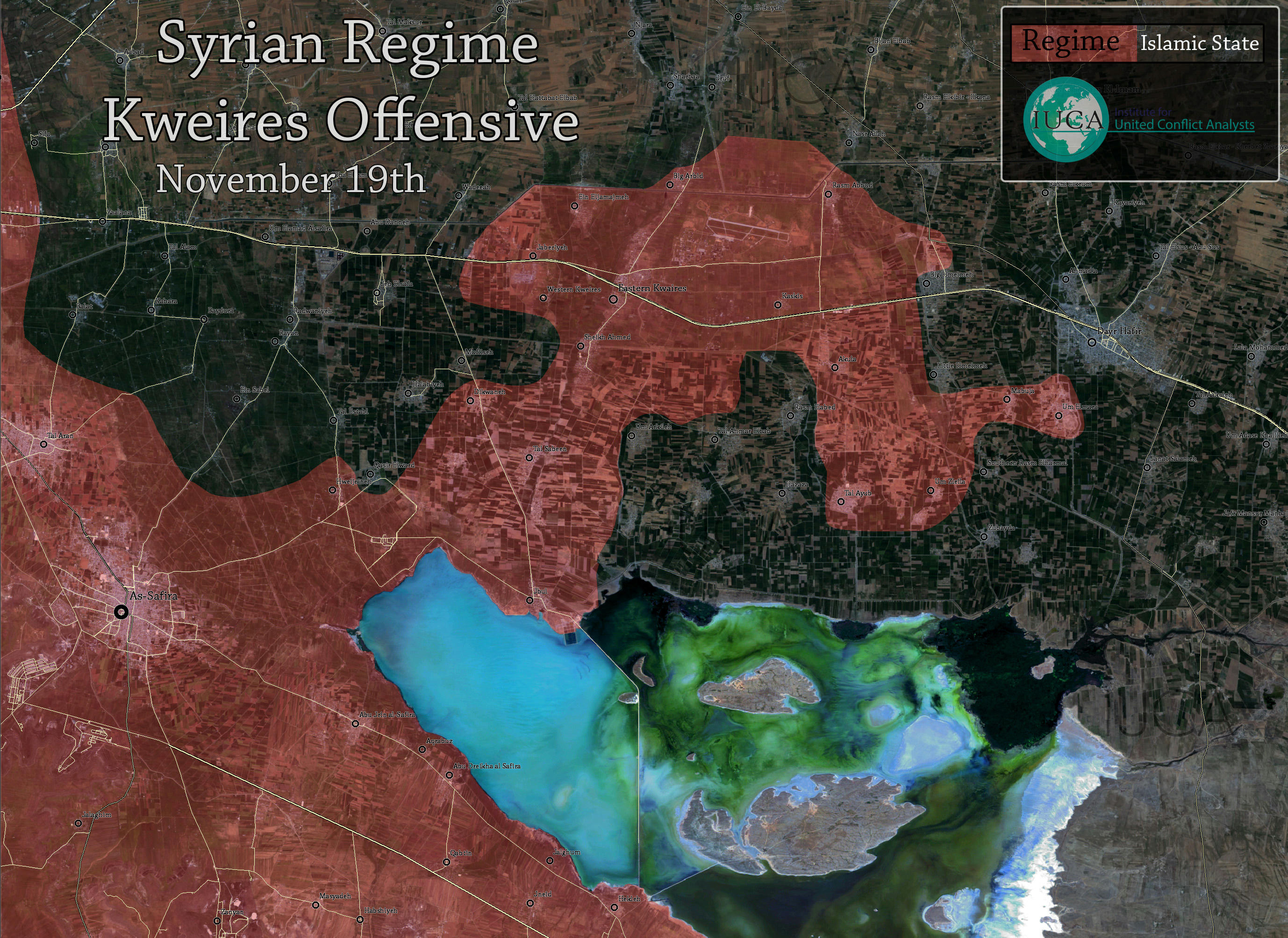
All pro SAA maps are way more modest with SAA gains near Kweiris airport compared to this map. I know maps made by pro gov/opp are not reliable source but masdar is saying the same http://s3.img7.ir/00Ab3.jpg Aqulah captured, not even close to Deir Hafer http://www.almasdarnews.com/article/tiger-forces-expand-the-buffer-zone-around-the-kuweires-military-airport-rasm-al-abid-grain-silos-captured/ Totholio ( talk) 18:13, 1 December 2015 (UTC)
- Here maps from opposition sources
here
here These maps show a completely different situation. So we must to comply the rules of editing according to which we cant use the maps as the reliable source for editing. Also this source
here not support data from this map
here Source clear said that Aqula and Aqula Farms, Tall Humaymah, under SAA also source said that the SAA is now within 5km from the western district of Deir Hafer.
here
37.53.148.162 (
talk)
18:40, 1 December 2015 (UTC)
- You are linking 2 week old maps,ofcourse the masdar source is supporting the data, without Aqulah it's impossible to control anything towards the south specially Tell Ayyub
Totholio (
talk)
19:24, 1 December 2015 (UTC)
- SOHR confirmed that the SAA advance in surroundings of the village Rasm Aboud and take control of the Rasm Aboud granaries. SOHR 37.53.148.162 ( talk) 19:47, 1 December 2015 (UTC)
-
Totholio But I think you are right about Tell Ayyub.
37.53.148.162 (
talk)
19:51, 1 December 2015 (UTC)
- SOHR report is from yesterday, I'm not saying SAA is on the back foot there, definitely not, just 1-2 villages not yet captured which is shown red on the map. Totholio ( talk) 16:49, 2 December 2015 (UTC)
- Totholio Governmnet source confirmed that the Tell Ayyoub and Umm Zulaylah to south of Aqulah still under ISIS. source 46.201.223.212 ( talk) 17:46, 3 December 2015 (UTC)
- You are linking 2 week old maps,ofcourse the masdar source is supporting the data, without Aqulah it's impossible to control anything towards the south specially Tell Ayyub
Totholio (
talk)
19:24, 1 December 2015 (UTC)
Baraghedeh changes to IS
ISIS "captured" from Islamists town of Baraghedeh, Northern Aleppo. -- 212.75.52.4 ( talk) 13:06, 3 December 2015 (UTC)MapMaker
- ISIS forces take control of Baragheda village in the northern suburbs of Aleppo.
here
FoXrEpOrTeR (
talk)
16:08, 3 December 2015 (UTC)
- SOHR said that ISIS take village Baragheda to north of Aleppo near Syrian-Turkish border. SOHR 46.201.223.212 ( talk) 17:24, 3 December 2015 (UTC)
- Rebels retake Baragheda from ISIS. here FoXrEpOrTeR ( talk) 19:07, 3 December 2015 (UTC)
Shaatat tribes(pro SAA) support SDF in Hasakah
Pro-opp. source (Local Coordination Committees of Syrıa) said that the today reinforcements arrived from the Shaatat tribes(loyal to Assad) for fight along with the SDF against ISIS in Shaddadi to south of city Hasakah. here here 46.201.223.212 ( talk) 21:37, 2 December 2015 (UTC)
I seen that too so how can rebel affiliates (apparently) fight along side Syrian Arab Army soldiers that these tribes men are basically, as they have fought with the republican guard in Hasakah and Deri El Zoir, I think all SDF half green half yellow should just be made yellow it seems its mostly ypg and very little "rebels" if any. — Preceding unsigned comment added by 213.94.232.61 ( talk) 12:08, 3 December 2015 (UTC)
The SDF has al Arab component of some 5000 to 7000 men. Those groups belong either to the Free Syrian Army of to local tribal forces. They are as following:
1. Kobani: Burkan al-Furat operations room 2. Raqqah province: Liwa Thuwar Raqqa (hundreds of fighters) and Burkan al-Furat 3. Hasakah province: some FSA (mainly Liwa Tahrir Souriya) and the local Arab Al-Sanadeed Force (1700 fighters)
I think we should make a new color for the SDF. The only problem is that the Kurds won't be an autonomous entity that way, whilst the YPG is the strongest component of the SDF. So, green-yellow dots should be put into place as long as we don't have a true SDF color. — Preceding unsigned comment added by 84.24.43.183 ( talk) 18:16, 3 December 2015 (UTC)
This discussion was done before, the conclusion is that SDF is represented by yellow. Green-yellow is a lie because the green here has nothing to do with the green of the rest of Syria. YPG (not kurds) fight under the banner of SDF now, so yellow means SDF and only YPG. That simple. Paolowalter ( talk) 19:06, 3 December 2015 (UTC)
- SDF consist on 90% from Kurdish forces YPG,YPJ and former FSA group Jaysh al-Thuwar(Revolutionary Army) which is now in alliance with YPG/SDF. So that editors agreed put icon for SDF in yellow color. Kurdish fighters play a dominant role in SDF. The SDF group is led by the main Kurdish fighting force in Syria, the known as the YPG. The Star FoXrEpOrTeR ( talk) 08:28, 4 December 2015 (UTC)
Katf Al-Ziyarah
Al Masdar states that Katf Al-Ziyarah was captured by SAA. It is not clear if it means Az Ziyārah or, as suggested on twitter Katf Al-Ziyarah in north Latakia. Any idea? Paolowalter ( talk) 12:56, 4 December 2015 (UTC)
- Paolowalter SAA takes control of Ketf Al-Ziyarah in NE Latakia countryside. here here here source Location: here here 46.201.223.212 ( talk) 14:12, 4 December 2015 (UTC)
Belligrant Colors
there are some difficulties showing SDF advances on the map while we have some rebels including ahrar sham fighting other rebels SDF (green vs green).
maybe its the time we make some changes in alliances. I think there are two types of rebels. those who ally JAN and those who are not. we can find some rebels including ahrar sham, jaysh al islam, jund al aghsa, zinki etc. whom often coordinate alnusra fighting kurds and SAA.and they never fought alnusra. maybe they better be grey or a variant of grey.
at the other side we can find moderate rebels (frankly they are a few on the map) including SDF. they could be green or any other color. 85.15.42.246 ( talk) 05:33, 29 November 2015 (UTC)
Question ...Does the SDF fight against the SAA .If not can they be classified as rebels?
Yes they can, since they reject the regime administration and rule their held areas independently from the regime
Well that maybe your interpritaton but they seem to kill more FSA and I.S. than Government Army troops . 86.178.102.85 ( talk) 15:23, 29 November 2015 (UTC)
- For now clear that SDF and Rebels/FSA no more allies at the moment they are enemies. Opposition sources confirmed that Rebels/FSA now fight against SDF. source video video source source source source source video video here hre here here Also rebels burned flags of SDF(offshoot of YPG) in Aleppo countryside. here [1] Pro opp. source said that for now the worst attitude betweeb the FSA and YPG (as SDF) since the beginning of war, after failed SDF offensive backed of Russian Air Force against rebels in Aleppo province. source 37.52.30.223 ( talk) 18:14, 29 November 2015 (UTC)
We don't care about that. Rebel groups fight against each other, so what ? Both are still rebels and their tensions should not care us. Our map shows the clashes between Rebels/Gov./Kurds and ISIS, everything else is just too detailed and not for this map, as this map is made to understand the Syrian conflict under normal conditions, for normal people. The current clashes between FSA and FSA under SDF coalition is just politic and nothing else. Ignore it and keep editing the map based on rules. DuckZz ( talk) 18:33, 29 November 2015 (UTC)
Hardly read something more nonsense. Once former FSA and FSA (if it still exists) fight with each other they are not in the same alliance anymore. Furthermore SDF is not fighting anymore (or as YPG has never fought) the government, the situation changes rapidly. As far as I can judge, government and SDF are de facto allies. They fight th esame enemies: IS, Al-Nusra, FSA (whatever that means), Turkey and Sausi Arabia. They are both supported by Russia. The only difference is that SDF is somehow backed by USA while government is opposed. Paolowalter ( talk) 20:04, 29 November 2015 (UTC)
We can add this to the description under the map: "
![]() = Kurds (Including
EV &
SDF )" or we can add: "
= Kurds (Including
EV &
SDF )" or we can add: "
![]() EV &
SDF ". (ping!
Prohibited Area). And
DuckZz this is one of the most important things that have happened on the ground since the Russian intervention and maybe also a result of it, so this tension care the situation a alot.
Rhocagil (
talk)
01:58, 30 November 2015 (UTC)
EV &
SDF ". (ping!
Prohibited Area). And
DuckZz this is one of the most important things that have happened on the ground since the Russian intervention and maybe also a result of it, so this tension care the situation a alot.
Rhocagil (
talk)
01:58, 30 November 2015 (UTC)
- Im opposed to the
for kurds + SDF. SDF is part of rebels supporting by world powers and may engage in the next government, while kurds might have some kind of autonomy in the next government. then their territory color should be clear and different from the others. Im oppose to the
 for the SDF too until the other rebels who help and coordinate Al-Nusra have the same color (green). soon in the future world powers will clarify terrorist and non-terrorist rebels and we have to make our map ready to indicate these facts.
85.15.42.246 (
talk)
07:08, 30 November 2015 (UTC)
for the SDF too until the other rebels who help and coordinate Al-Nusra have the same color (green). soon in the future world powers will clarify terrorist and non-terrorist rebels and we have to make our map ready to indicate these facts.
85.15.42.246 (
talk)
07:08, 30 November 2015 (UTC)
- I have long been seeking a solution for this problem and got a very good solution. The original secular FSA who have now shrunk to small groups allied with YPG under umbrella name of SDF should retain their green color, while the salafist/islamist jihadi groups fighting for Sharia law such as Ahrar ash-Sham and their brethren should be labelled in a light grey, as apposed to Jabhat al-Nusra who are labelled in dark grey (could be further darkened a little bit more than it is now) and ISIS in black.
Roboskiye (
talk)
16:18, 30 November 2015 (UTC)
-
Roboskiye That´s an acceptable move to, but maybe a darker green for Ahrar and company. But I´m still in favor of
for SDF
Rhocagil (
talk)
16:37, 30 November 2015 (UTC)
-
Roboskiye That´s an acceptable move to, but maybe a darker green for Ahrar and company. But I´m still in favor of
- I have long been seeking a solution for this problem and got a very good solution. The original secular FSA who have now shrunk to small groups allied with YPG under umbrella name of SDF should retain their green color, while the salafist/islamist jihadi groups fighting for Sharia law such as Ahrar ash-Sham and their brethren should be labelled in a light grey, as apposed to Jabhat al-Nusra who are labelled in dark grey (could be further darkened a little bit more than it is now) and ISIS in black.
Roboskiye (
talk)
16:18, 30 November 2015 (UTC)
- Im opposed to the
-
Roboskiye SOHR clear said that clashes continued between Kurdish SDF and rebels around Kashtaar and al-Malkia in A’zaz countryside what killed 10 rebels and 8 SDF.
SOHR So SDF it is the Kurdish forces plus Jaysh al Thuwar which joint to Kurds in their fight against rebels. Rebels/FSA now fight against SDF and rebels burned flags of SDF(offshoot of YPG) in Aleppo countryside.
here
[2] So we need use
for kurds + SDF.
37.52.29.85 (
talk)
16:45, 30 November 2015 (UTC)
- About one third of YPG are non-ethnic Kurds, mostly secular or leftist Arabs. Moreover, about two thirds of non-YPG groups who are active inside SDF are ethnic Arabs. For example, in recent clashes in northern Aleppo several ethnic Arab members of SDF got killed or beheaded by islamists FSA. So yellow does not necessarily represent Kurdish. Roboskiye ( talk) 16:56, 30 November 2015 (UTC)
- I agree with
Roboskiye, we should use different colours for Salafist Rebels and 'Moderate Rebels'. The Moderates should retain the light-green icon whilst the Salafists and Radical Islamists should be given a dark-green colour. I also think that SDF should be identified as Kurdish because of its strong connections and affiliations to the YPG, however the yellow symbol should specify that it includes SDF, which includes Arabic, non-Kurdish, fighters which constitute a minority of the SDF. Such as
= Kurds (Including
SDF non-Kurdish fighters]].
Prohibited Area (
talk)
17:12, 30 November 2015 (UTC)
- I agree with
Roboskiye, we should use different colours for Salafist Rebels and 'Moderate Rebels'. The Moderates should retain the light-green icon whilst the Salafists and Radical Islamists should be given a dark-green colour. I also think that SDF should be identified as Kurdish because of its strong connections and affiliations to the YPG, however the yellow symbol should specify that it includes SDF, which includes Arabic, non-Kurdish, fighters which constitute a minority of the SDF. Such as
- The solution is as following:
-
= YPG/YPJ
-
= SDF
-
 = Secular FSA
 -
 = Islamist FSA
 -
 = al-Nusra
 - Roboskiye ( talk) 17:26, 30 November 2015 (UTC)
-
Roboskiye Very good idea. For now it is the best solution. Good job!
37.52.29.85 (
talk)
17:54, 30 November 2015 (UTC)
- It´s a somewhat good proposition, but i would like the forum to specify witch are the "secular FSA"? in my view the only secular FSA is the ones that have joined up in SDF. Anyway I would not consider use of the light grey (it blends in a little bit to well in the map background). I would prefer something more dark green and like this
-
 = Ahrar ash-Sham/ Islamist FSA
Rhocagil ( talk) 20:11, 30 November 2015 (UTC)
All FSA are islamits they snackbaring all time and forced women to wearing Vein when they are
Syrian army and Kurds are secular but Kudrs are separatits Kurds just controlled the so called SDF
- Most, but not all. There are over a dozen of smaller groups who have survived islamists pressure/conquest. Currently most secular FSA are operating in areas close to YPG control, though there is another one emerging in south with US support. I think there are even a number of secular FSA pockets in western Syria too. Roboskiye ( talk) 20:13, 30 November 2015 (UTC)
- Well I agree to this, just use another color then this grey on
.
Rhocagil (
talk)
20:20, 30 November 2015 (UTC)
- The reason for choosing grey is it is a shade of black, similar to dark grey (al-Nusra) and solid black (ISIS), indicating that all these groups are islamist and fighting more or less for the same aim: an Islamic political entity ruled by Sharia law. We can choose another shade of grey as shown in this page:
Shades of gray. Silver for Islamist FSA and dimgray for Jabhat al-Nusra.
Roboskiye (
talk)
20:32, 30 November 2015 (UTC)
- "slategray" then maybe, as long as it has contrast to the maps background color. Rhocagil ( talk) 20:44, 30 November 2015 (UTC)
- The reason for choosing grey is it is a shade of black, similar to dark grey (al-Nusra) and solid black (ISIS), indicating that all these groups are islamist and fighting more or less for the same aim: an Islamic political entity ruled by Sharia law. We can choose another shade of grey as shown in this page:
Shades of gray. Silver for Islamist FSA and dimgray for Jabhat al-Nusra.
Roboskiye (
talk)
20:32, 30 November 2015 (UTC)
- I disagree using
for SDF. I propose:
-
= Kurdish Forces (Including Kurdish Affiliates:
SDF Coalition)
-
= Moderate Rebels
-
= Salafists
-
= Al-Nusra
The yellow dot should also include a notation mentioning the fact there are non-Kurdish fighters embedded in SDF coalition which are classed as yellow. We should decide on which rebels that hold territory should be classed as 'Salafists' [Radical Rebels] and which should be 'moderate' opposition. We should then link the list to the key. Prohibited Area ( talk) 20:45, 30 November 2015 (UTC)
-
Should be specifically 'Kurdish Forces' and not YPG as the icon already encompasses Kurdish-affiliated Sutoro, Christian and Assyrian militia and if the planned update goes ahead, it will also include the SDF.
Prohibited Area (
talk)
20:49, 30 November 2015 (UTC)
- I strongly disagree using the word "moderate" it´s subjective word. What is "moderate" according to Saudi Arabia is no way "moderate" to me. "Secular" is a better word.
Rhocagil (
talk)
20:55, 30 November 2015 (UTC)
- I agree. However again secular may be inaccurate to describe the rebels in question. Secular implies that they are not Islamist when in fact i'm quite confident 100% of rebel groups are Islamists - however others more so than others. I think we need a different adjective for the 'moderate'-'secular' rebels. Prohibited Area ( talk) 21:09, 30 November 2015 (UTC)
- Should we keep
as Syrian Opposition, and only add
= Salafists. This would prevent us from inaccurately describing the 'moderate' forces.
Prohibited Area (
talk)
21:17, 30 November 2015 (UTC)
- I strongly disagree using the word "moderate" it´s subjective word. What is "moderate" according to Saudi Arabia is no way "moderate" to me. "Secular" is a better word.
Rhocagil (
talk)
20:55, 30 November 2015 (UTC)
-
Therefore:
-
= Kurdish Forces (Including
Kurdish Affiliates)
-
= Syrian Opposition
-
= Salafists
-
= Al-Nusra
Can we also amend Armed Groups in Syrian War to detail Salafist and Syrian Opposition groups and use that as a reference for the key. Prohibited Area ( talk) 21:20, 30 November 2015 (UTC)
I say this is a stupid idea. and will be waist of time and effort and unmaintainable. I longtime apposed the seperate color for Al-Nusra and here it is going even worse. And all nusra vs FSA control on our map is wrong. no other map has this distinction . Nusra exists everware in green are and in small groups. no single evidence of them controlling any land with no othergroup presence. the map is perfect as it is. clashes between kurds and rebels is clear no need for more colors if there are some arabs between kurgs so what they are still kurds domilated Helmy1453 ( talk) 21:41, 30 November 2015 (UTC)
-
Helmy1453 It´s important to show that the Kurdish force is more then a kurdish force because "moderate" FSA join them in SDF, even if kurds are majority. And according to me we can mark all green dots grey because I se al elements that collaborate with Al-Nusra as Al-Nusra. But thats my private opinion and here we need a big consensus. But the absolut minimum change should be to explain yellow as *
= Kurdish Forces (Including
Kurdish Affiliates)
Rhocagil (
talk)
21:59, 30 November 2015 (UTC)
- And red is more than just SAA still it is one color. one team means one color this discussin happened when people wanted seperate color for Hezbulah . and we agreed that as long as they are the same team as SAA and not clashing with them then they are all red. the same some groups go and fight with Kerds fine let them all be yellow, call them kurds+SDF but they are not rebels. let me put it this way if they are not bombed by Russian and SAA flights they are not rebels or opposition and they should not be green Helmy1453 ( talk) 22:23, 30 November 2015 (UTC)
- Jabhat al-Nusra who is allied to salafist FSA has its own color but not non-salafist FSA who are considered as infidels and robbers by salafist FSA, and therefore at fierce fighting with eachother?! BTW The non-salafist FSA should not be marked with same color as their enemies i.e. Salafist FSA. Maybe simply yellow? Then comes the complicated question: what about other non-salafist FSA elsewhere in Syria?
- Regarding Hezbullah, it is not a separate belligerent allied to SAA, but it is a supporter of SAA, who fights on behalf of SAA. So Hezbullah does not need a specific color other than red.
Roboskiye (
talk)
08:31, 1 December 2015 (UTC)
- "Then comes the complicated question: what about other non-salafist FSA elsewhere in Syria? " It is not complicated it is simple. Salafie or not Orthodux Russian or Extremist Shiaa Iraninan Militia doesn't make difference. the map is not to describe my or your political Idea. All what you want is to POV this map . Stop pushing your political agenda on the map to support Assad ans Russian point of view. It is simple this map is Control situation on land. groups that fight together and controls together gets the same color. All oppsition including Al-nusra are fighting together and shariong control on the land they should be the same color (green). Kurds and SDF fights together and rule together they get the same color (Yellow). and the same for red and black simple . THERE IS NO CLASHES BETWEEN SALAFIE AND MODERATE FSA . they are allies and work and control together. co fightuing and coexisting, these are the facts and should bee ALL SAME COLOR.
-
Roboskiye
Helmy1453
Rhocagil
Prohibited Area Need villages of Malikia, Tatumrash, Shawarghet el Arz, Tanab and Al Kishta as undr contol of
Islamist FSA. Pro opposition source confirmed this
source And I agree with this propose from
Prohibited Area:
-
= Kurdish Forces (Including Kurdish Affiliates:
SDF Coalition)
-
= Moderate Rebels
-
= Salafists
-
= Al-Nusra
- It will clarify the map. 37.53.148.162 ( talk) 19:09, 1 December 2015 (UTC)
- FSA retake the Grain Silos in northern Aleppo from SDF/YPG video from rebels. 37.53.148.162 ( talk) 19:18, 1 December 2015 (UTC)
This is a stupid idea and it will ruin the map. This is wikipedia and not twitter where trolls and underage kids have disqusions about "goatfuckers and the difference between 2 million rebel groups, islamists, bit less, more less, less more, terrorists, extremists, moderate, less moderate". Please spare us this nonsense and keep editing the map as it this. DuckZz ( talk) 23:00, 1 December 2015 (UTC)
- What do we do when rebels clash with each other then, as in North Aleppo right now? Given this map is meant to make an accurate portrayal of the conflict, we would be omitting a conflict in the war.
Prohibited Area (
talk)
11:41, 2 December 2015 (UTC)
- . Prohibited Area I answered this question already twenty times ? don't you even read? THERE IS NO CLASH BETWEEN REBELS in North Aleppo. Clashes are between rebels and SDF which no rebel consider as part of rebels. the Russia supports SDF and don't consider it part of rebels, Goverment doesn't attack them and doaes't count them as rebels . THEY DONT FIGHT SAA and don't count themselfs as rebels. They have a color which is yellow. put a notation on yellow saung kurds and SDF . perid problem solved. no need for any more colors. what is wrong with you perople ?? ( talk) thank you . Helmy1453 DuckZz 14:22, 2 December 2015 (UTC)
- What do we do when rebels clash with each other then, as in North Aleppo right now? Given this map is meant to make an accurate portrayal of the conflict, we would be omitting a conflict in the war.
Prohibited Area (
talk)
11:41, 2 December 2015 (UTC)
It seams that at least there is a consensus of this *
![]() = Kurdish Forces (&
SDF Coalition)
Rhocagil (
talk)
18:34, 2 December 2015 (UTC)
= Kurdish Forces (&
SDF Coalition)
Rhocagil (
talk)
18:34, 2 December 2015 (UTC)
-
Helmy1453 So the coalition Jaysh al-Thuwar, which is a part of the FSA, and consist of formers members of the FSA Hazzm and SRF Movements is not a rebel group? OK, thanks for the clarification. Also there were recent clashes between AaS and another rebel group in southern Idlib, however the clashes probably subsided and were major.
Prohibited Area (
talk)
21:05, 2 December 2015 (UTC)
- Prohibited Area Bashar Al Assad himself sated that some former FSA members and entire groups from Rif-Dimashk joined him in fighting ISIS and now are fighting with him in Lazkia battles. So According to your logic these are rebels and should be stated as green ??? also FSA has many former SAA ofisers that changed sides so according to your logic these should be red ??? you are talking nonsense. former FSA groups changed sides and jouned SDF forming coalition Jaysh al-Thuwar they are out of rebles . they are yellow now something different , rebels fight government these are defecto allies of government . end of discussion. Helmy1453 ( talk) 13:34, 3 December 2015 (UTC)
-
Helmy1453 So the coalition Jaysh al-Thuwar, which is a part of the FSA, and consist of formers members of the FSA Hazzm and SRF Movements is not a rebel group? OK, thanks for the clarification. Also there were recent clashes between AaS and another rebel group in southern Idlib, however the clashes probably subsided and were major.
Prohibited Area (
talk)
21:05, 2 December 2015 (UTC)
All insurgents are except the Kurds are islamists
Al Qaeda (Nusra) have minor or major presence in all areas controlled by the Insurgents the SDF is totally controlled by the Kurds- — Preceding unsigned comment added by 201.210.138.186 ( talk) 21:49, 2 December 2015 (UTC)
- We cannot use ethnic term to name political and military factions in this war. Kurds are present in all fighting parties. Of course many, maybe the majority, support the YPG. On the other hand, since the beginning some non kurds joined YPG as well. That is more evident now with the formation of SDF. Therefore we must adopt
= SDF (including YPG). Some previous rebels forces joined SDF (like Jaysh al Thuwar) and apparently are supported by Russia. In practice those group changed side, their goal is not anymore the overthrow the government but fight IS and other rebel groups. As to the suggestion to distinguish between Salafist, Non-Salafist, secular FSA, it simply makes no sense. There is no such a distinction on the ground, even if we agreed there is no way we can sort which area is occupied by whom. Conclusion: once we turn all yellow-green to yellow (SDF) the map is fine.
Paolowalter (
talk)
08:39, 3 December 2015 (UTC)
- As stated above by other contributors, there seems to be a consensus of changing yellow-green to yellow. The description for yellow should be:
= YPG (including SDF).
Roboskiye (
talk)
09:22, 3 December 2015 (UTC)
-
Paolowalter,
Roboskiye Fine, I think it´s better like this
= Kurdish Forces (&
SDF Coalition) Kurds are majority, anyway included link to SDF would be preferred.
Rhocagil (
talk)
12:11, 3 December 2015 (UTC)
- Roboskiye I agree with your statment Helmy1453 ( talk) 13:40, 3 December 2015 (UTC)
-
Paolowalter,
Roboskiye Fine, I think it´s better like this
- As stated above by other contributors, there seems to be a consensus of changing yellow-green to yellow. The description for yellow should be:
I have edited the template to that
![]() = Kurds (Including
Affiliates. I will await furthermore discussion and overall consensus on whether to expand these edits so that
File:Disc plain green dark.svg = Salafists and
File:Dot lime green.svg = Moderate Rebels.
Prohibited Area (
talk)
15:02, 3 December 2015 (UTC)
= Kurds (Including
Affiliates. I will await furthermore discussion and overall consensus on whether to expand these edits so that
File:Disc plain green dark.svg = Salafists and
File:Dot lime green.svg = Moderate Rebels.
Prohibited Area (
talk)
15:02, 3 December 2015 (UTC)
- Prohibited Area Thank you for the edit. Onequesion Ayn Issa grain soils is still green is that on porpuse or that was an error. Just want to make sure before making wrong edits. Helmy1453 ( talk) 15:55, 3 December 2015 (UTC)
Such the good and intresting solution in this issue. Allah bless of Kurds! Sûriyeya ( talk) 16:52, 3 December 2015 (UTC)
- Helmy1453 I'm not sure on who controls the silos however presumably it would be under Euphrates Volcano (SDF) control. I will change it to yellow. Thanks for pointing that out. Prohibited Area ( talk) 19:06, 3 December 2015 (UTC)
- Same goes for SMC inside Hasaka and Qamishli city maps. It is currently shown as blue but in fact it is a member of SDF. Roboskiye ( talk) 21:28, 3 December 2015 (UTC)
I'm still against this. Rebel factions have clashed in the past, yet we still count them as rebels. Furthermore, the claim that all non-SDF rebels are extremists is incredibly biased, and some of the comments here seem suspiciously opinionated. We cannot let bias or our own personal opinion take precedence over fact. Plus, the Kurd's relationship with the government is mixed at best. The same goes for their relationship with the rebels. I see no reason for the change in color. Anasaitis ( talk) 20:09, 3 December 2015 (UTC)
- Roboskiye Helmy1453 Rhocagil Prohibited Area The last confirmation that we need use yellow color for SDF it is that SDF comprises nearly the 40,000 fighters source and most of them are 30,000 units from the YPG. source plus YPJ and Jaysh Al Tuwar which joined to YPG. 46.201.223.212 ( talk) 13:46, 4 December 2015 (UTC)
If we should not add more colors to the map it would be logical to include all of the
Jaish al-Fatah operation room under the color
![]() of Al-Nusra. They are all co-operating and they all are in favor of a sharia-state.
Rhocagil (
talk)
00:41, 5 December 2015 (UTC)
of Al-Nusra. They are all co-operating and they all are in favor of a sharia-state.
Rhocagil (
talk)
00:41, 5 December 2015 (UTC)
why al-Qaeda's allies are green?
I mean MWAA, JAAD, and other groups not presented in SRCC. It will be much more logical if they will be displayed gray as JaN. - 81.177.127.236 ( talk) 20:02, 3 December 2015 (UTC)
- Anhar Al Sham, Jund Al Aqsa and Junud Al Sham it is allies of Al Nusra. NOW News NOW News 46.201.223.212 ( talk) 08:52, 4 December 2015 (UTC)
- Yes it would be perfectly logical to display those as grey, in fact all of the Jaish al-Fatah operation room Rhocagil ( talk) 00:33, 5 December 2015 (UTC)
Yes of course, then remove the green color, replace is with grey because we know Al Qaida makes up 90% of rebels and 9% are other jihady groups, 1% are foreign moderates which we should mark as green in 1 or 2 villages. Now go back to twitter and spit your anger somewere else. DuckZz ( talk) 01:30, 5 December 2015 (UTC)
Yes of course. Make everything grey, because the entire of northern Syria is in the hands of throat-cutters (sarcasm). No, wait, even better: make everything black and quote Russian sources, because they are bombing Islamic State in Latakia and Idlib! So, back to the real world and objectivity: bad idea. — Preceding unsigned comment added by 84.24.43.183 ( talk) 13:40, 5 December 2015 (UTC)
- You both are not funny, 90% of fsa is working with al qaeda. Everyone knows there are no moderates Totholio ( talk) 19:52, 5 December 2015 (UTC)
Government force advance in North Latakia
SAA captured the al Frolloq forests and Tall Ghazalah Hill in the northern countryside of Latakia. SOHR FoXrEpOrTeR ( talk) 11:14, 6 December 2015 (UTC)
eastern Ghouta
Regime forces with support Hizbullah seize over wide areas in Marej in eastern Ghouta after intense clashes with opposition forces. source 46.201.223.212 ( talk) 18:48, 6 December 2015 (UTC)
Al Sooda, Latakia, Green??
Al Sooda in Latakia is green but is a newly added village of last month and was added green with no source, every map I see pro opp and pro gov this is not shown as rebel held, it is a very small village, why would they bypass this small village on a main supply route to take a bigger town? Plus all the force in that area. Just making the case that it is highly unlikely this is rebel held. — Preceding unsigned comment added by 213.94.239.182 ( talk) 16:30, 7 December 2015 (UTC)
- Map of this area available in the last month are somehow contradictory between themselves in this area.
Some maps report e.g. Turus and Bayt Ablak rebel controlled. Paolowalter ( talk) 22:52, 7 December 2015 (UTC)
The coordinate of Al Sooda are lat = "35.803", long = "35.981" that on wikimapia corresponds to [Karabacakli http://wikimapia.org/#lang=it&lat=35.803057&lon=35.980997&z=15&m=b&show=/33804611/Karabacakli]. The name is wrong the possession dubious, the village is tiny and of no particular relevance: I support removing it. Paolowalter ( talk) 23:14, 7 December 2015 (UTC)
Twitter reports of Mughayriyah taken by SAA no confirmation yet . 86.135.154.68 ( talk) 17:30, 7 December 2015 (UTC)
Peto Lucem had this as rebel held on the 21st November https://pbs.twimg.com/media/CUWHh0lWwAArlmz.jpg Conservative Thinker ( talk) 17:40, 7 December 2015 (UTC)
- SAA\NDF captured village Mughayriyah to north-east of villag Kafr Dulbah. source FoXrEpOrTeR ( talk) 18:23, 7 December 2015 (UTC)
https://twitter.com/miladvisor/status/673934729884901376 reports that SAA pulled out shortly after taking it. Paolowalter ( talk) 23:14, 7 December 2015 (UTC)
- Wikimapia is very unreliable (specially) in this area. I saw some recently added hills, switched to terrain mode and found a valley there! Whoever is adding these data is not very precise. I recommend detailed check before using wikimapia data. --
Hogg 22 (
talk)
07:00, 8 December 2015 (UTC)
- Reliable source said that the SAA advance in Latakia and captured Burj Al-Qasab, the strategic village of ‘Ikko, the small villages of Bouz Al-Khirbat, Beit Fares, and Al-Mughayriyah, Point 1154 and Point 1112 near the southern perimeter of Kabani. source FoXrEpOrTeR ( talk) 07:56, 8 December 2015 (UTC)
Red and Yellow icons for Oil/gas
There is a redundant shade of black in red and yellow icons for oil/gas which gives the wrong impression as if they are under siege by ISIS. Can someone correct this by changing the current icons to the respective monochromatic colors. Roboskiye ( talk) 16:29, 8 December 2015 (UTC)
- Agreed. It is a bit confusing. ArchPope Sextus VI ( talk) 19:25, 8 December 2015 (UTC)
- wanted to say that comment longtime ago, but feard overloading the admins who can do it. Helmy1453 ( talk) 21:01, 8 December 2015 (UTC)
SAA readvance south Aleppo
Government forces captured villages of Khalasah, Al Hamra, Zaytan, Qal`ajiyah and most part of Birnah. SOHR source source source FoXrEpOrTeR ( talk) 13:48, 7 December 2015 (UTC)
- Didn't we already have Khalasah and Al Hamra under SAA control anyway? This means that they were under rebel control until today, in contradiction to previous al-Masdar reports? Schluppo ( talk) 17:26, 7 December 2015 (UTC)
It was taken by rebels last week but not reported on much . 86.135.154.68 ( talk) 17:54, 7 December 2015 (UTC)
- Schluppo Sometims situation may change too fast, and not always possible to keep track of all changes on the ground. FoXrEpOrTeR ( talk) 18:20, 7 December 2015 (UTC)
Rebels take full control of Banes [3]. Also there is conflicting information about control of Birnah in two al-Masdar articles from today: 14 hours ago: SAA control 80 percent of village Burnah. [4]. 12 hours ago: Birnah is "islamist-held" [5]. I would propose to go with the latest article, that is, the article stating that Birnah is islamist-held. Schluppo ( talk) 21:51, 8 December 2015 (UTC)
- I agree to keep Birnah contested for the time being and wait for a reliable source to cleary and unambigously report on the matter. Schluppo ( talk) 22:16, 8 December 2015 (UTC)
Semi-protected edit request on 5 December 2015
This
edit request to
Module:Syrian Civil War detailed map has been answered. Set the |answered= or |ans= parameter to no to reactivate your request. |
"YPG (and Affiliates" should be changed to "YPG (and Affiliates)" or even better to "YPG and allies" given that SDF is an alliance (as stated on their wikipedia page) and affiliate isn't that clear as to what it means. Formagella ( talk) 22:53, 5 December 2015 (UTC)
- Done. Schluppo ( talk) 07:16, 6 December 2015 (UTC)
SDF are only a force of 2000 (If that) men mixed in with around 40,000 Kurds, just because someone makes a wiki page doesn't mean its factual. This map would be to complicated if we started adding all the various groups that make up Syrian Armys alliance, which many have forces much larger such as Hezbollah estimated 15000-20000 where is their colour? Or the IRGC 10000 where is their colour? — Preceding unsigned comment added by 213.94.237.246 ( talk) 23:17, 5 December 2015 (UTC)
- SDF comprises nearly the 40,000 fighters source and most of them are 30,000 units from the YPG. source plus YPJ Also SAA have 178,000 fighters source Hezbollah (4,000-5,000 in Syria) and more then 1,000 Quds forces all these part of governmnent forces under the supervision of the Syrian army and they jointly with SAA hold areas and we use for them the red color. Since we use green for all the rebel groups such as: FSA(more 40,000), Islamic Front(40,000-60,000) and some others. With the exception of such as: Anhar Al Sham, Jund Al Aqsa and Junud Al Sham it is allies of Al Nusra. source source for these groups we use grey color. FoXrEpOrTeR ( talk) 11:11, 6 December 2015 (UTC)
- Wouldn't it be better to just use "SDF" in the legend? ArchPope Sextus VI ( talk) 01:40, 10 December 2015 (UTC)
YPG advance ahainst al Nusra/Ahrar al-Sham to north Aleppo
Clashes broke out between the Kurdish fighters and al-Nusra militants in the villages of Tanb, Kashatar and al-Malikiya north of Aleppo. Also Al Nusra/Ahrar al-Sham bombing the YPG-held village of Shawargha. source Sûriyeya ( talk) 10:26, 9 December 2015 (UTC)
This is pro-Kurdish source. can't be used as an evidence for kurdish gains. do you have pro-rebel or pro-government source ? Helmy1453 ( talk) 16:05, 9 December 2015 (UTC)
- Generally speaking that is right, but wasn't aranews considered 'relaible source' so that all news from it could be used? Paolowalter ( talk) 16:49, 9 December 2015 (UTC)
- Honestly I never heard of aranews before. who considered it a 'relaible source' ? I know that per this page AL-Masdar and SOHR are the only confirmed reliable source no matter what side they report advances to .
Helmy1453 (
talk)
17:17, 9 December 2015 (UTC)
- ARA News it is Kurdish pro-FSA and pro-YPG source but clear anti-SAA source. 178.94.222.47 ( talk) 20:59, 9 December 2015 (UTC)
- The source says SDF advances againist Al-Qaida in northern Alleoppo. So it considers all non SDF rebels Al-Qaida or Islamic State. They are clearly pro Kurds. and can't be used for kurdish advances. If pro rebel or pro-government states these advances I will accept it. otherwise I can brign pro Islamic sorces claiming they still control Tal-Abiad.
Helmy1453 (
talk)
21:45, 9 December 2015 (UTC)
-
Prohibited Area Why don't you just put the entire green on map to black based on RT claims that Russain airstrikes is tageting Islamic state in Idlib and Aleppo. your edits moving rrandom cities to gray is really really unacceptable.
Helmy1453 (
talk)
21:53, 9 December 2015 (UTC)
- Helmy1453 I didn't realise this discussion was occuring. I would identify ARA News as a reliable source for editing, and has been used for Kurdish advances in the Hasakah region therefore I presumed it was also acceptable in any other region of Syria, especially when anti-Kurdish sources specifically do not state there losses to protect morale, the only reliable way of representing the war is to use biased sources as long as they are reliable. RT, isn't reliable. Prohibited Area ( talk) 09:31, 10 December 2015 (UTC)
-
Prohibited Area Why don't you just put the entire green on map to black based on RT claims that Russain airstrikes is tageting Islamic state in Idlib and Aleppo. your edits moving rrandom cities to gray is really really unacceptable.
Helmy1453 (
talk)
21:53, 9 December 2015 (UTC)
Homs - Al-Waer district
According to Al-Masdar, rebels and the Army managed to agree in leaving of rebels the district thus all Homs is under control of the Syrian goverment. The rebels have yet to leave the area, but there are no clashes [6]. Oroszka ( talk) 20:18, 2 December 2015 (UTC)
For now it should probably be marked as under truce. Rhocagil ( talk) 18:39, 2 December 2015 (UTC)
Change to cease fire if we no have more news will be change to contested again the next days -- LogFTW ( talk) 22:06, 2 December 2015 (UTC)
Al-Waer is under truce for sometimes till evacuation is completed. Once evacuation is completed, it goes to red, see e.g. http://www.dailystar.com.lb/News/Middle-East/2015/Dec-02/325534-deal-reached-for-last-holdouts-to-exit-homs.ashx. Paolowalter ( talk) 08:07, 3 December 2015 (UTC)
- Paolowalter Rhocagil Oroszka [ according to this] some rebels will remain in al-Waer following truce and therefore the suburb should remain contested or under joint control of rebels and govt. Prohibited Area ( talk) 19:27, 10 December 2015 (UTC)
I think the area now is considered reconciled. The rebell parts that didn't agree to were transferred to Idleb. The rebell part that did agree stays and will act as some kind of protector to the peace-agreement. Thera are other areas like this around Damascus. The area should not be marked as contested it should be marked as under peace (purple) or as government (red). Rhocagil ( talk) 21:51, 10 December 2015 (UTC)
- In practical reason at the end of the period it should go red because the truce is a thinly veiled form of surrender. But honestly it does not matter much. The war is over in al-Waer. Paolowalter ( talk) 23:22, 10 December 2015 (UTC)
Mahin and Huwwarin
Here SOHR stats SAA bombed the two towns... http://www.syriahr.com/en/2015/12/clashes-in-homs-and-lattakia-countrysides/ ...maybe they really said "around" them and this was a bad translation, or the two towns are back in IS hands? Not clear, need to read the original Arabic... Fab8405 ( talk) 11:02, 10 December 2015 (UTC)
- SOHR said that ISIS racaptured Mahin and Huwwarin.
source
Sûriyeya (
talk)
12:03, 10 December 2015 (UTC)
- Pro-Gov. source also confirmed that the ISIS captured Mahin and claim that clashes still ongoing in Huwareen. Al Khabar Sûriyeya ( talk) 14:21, 10 December 2015 (UTC)
IS-sources claim that IS took Jabal al-Hazzm (aka Hizam Hills) near Sadad, but we have to wait for reliable sources to report on the situation in this area. Schluppo ( talk) 17:36, 11 December 2015 (UTC)
Tell Ayyoub and Umm Zulaylah south-east of Kweiris Airbase
According to our map (and based on previous al-Masdar reports), SAA controls these two villages for several weeks. Of course we cannot use the folowing pro-SAA map as a source, but it shows current pro-government claims: https://twitter.com/PetoLucem/status/675063271653810178. So I think it is appropriate to doubt whether SAA really controls these two villages, and in fact, anything south-east of Aqulah farms. We should look out for reliable information about actual control on these locations. Also I would like to note: al-Masdar is reporting a lot of fishy or at least ambigous information in the recent weeks. Schluppo ( talk) 00:10, 11 December 2015 (UTC)
- I'am telling this since weeks... there was 0 footage from Tell Ayyoub
Totholio (
talk)
09:37, 11 December 2015 (UTC)
- Some times the SANA also said that it is ISIS-held towns. Sûriyeya ( talk) 10:28, 11 December 2015 (UTC)
Multiple pro-Government sources have these villages as ISIS held. I do consider al-Masdar reliable but they are not perfect (no source is) and the evidence is pretty clear that they have got this wrong. Conservative Thinker ( talk) 12:01, 11 December 2015 (UTC)
Seams like they should be changed to black for now. Rhocagil ( talk) 18:59, 11 December 2015 (UTC)
Goverment forces capture the ISIS town of Om Twaynah
Source [7] Mr.User200 ( talk) 13:02, 11 December 2015 (UTC)
- SAA captured villages of Umm Twaynah,Zanuba and al-Qatshyeh. source source Sûriyeya ( talk) 11:47, 12 December 2015 (UTC)
Syrian Civil War detailed map: Dating the map
Posted 12/9/2015. The map says "This page was last modified on 12 November 2015, at 07:28," whereas that is clearly not true, per JPG and "talk page" discussion. Is there not a better way of dating changes and identifying significant changes that have occurred than digging through the debates on the "talk page?" My suggestion is that the map page should be undated, and that in place of the date near the page bottom there should be a link to a "log page" summarizing significant changes, minimally with dates and description of change. For example, I had to dig deep to understand that the color changes south of Hasakah and in northwest Raqqah province are due, apparently, to a change in definitions, not a change in territorial control. --- Thanks, PNA PaulNalabama ( talk) 23:03, 9 December 2015 (UTC)
- One can find the detailed editing history here. Dr Bug (Vladimir V. Medeyko) 13:58, 13 December 2015 (UTC)
Latakias Border with Turkey in control of The Syrian Arab Army.
The situation in Latakia North along the border has been fully controlled by the SAA, lack of updates over the last three weeks means there is now 7-10 strategic hilltops and around 20 towns and villages along this route that are not shown in Syrian Armys control,,Not even on the map, I bet if it were some Al queda FSA group though it would be updated instantly. Al masdar has been active in stating most of these villages over the last 3 weeks, why has latakia not been updated??? just blanks where the SAA have been advancing??? and This map just looks the same for the last year in Latakia area even though in the last 3 weeks over 170 km squared captured here:
http://en.alalam.ir/news/1768499
http://sana.sy/en/?p=63906 — Preceding unsigned comment added by 213.94.238.111 ( talk) 17:41, 12 December 2015 (UTC)
- I and others update quite regularly the map relying mostly on Al Masdar. In some cases it is difficult to locate the positions of hills and villages, in other I did not mind changing small hills close to toher positions in order not to clutter the map. The sources you quote are heavily biased pro-government and cannot be used. If you have reliable sources reporting change of control not recorded on the map please post them here. Paolowalter ( talk) 22:28, 13 December 2015 (UTC)
A useful resource for maintaining this map.
I've made this kmz file. It's useful for both making sure that the cities and towns marked on this map are in the right place and also for identifying cities that we have overlooked. I don't know Arabic so it's hard for me to find sources on these cities but it might be useful for someone else. Some of these cities are really obviously under one groups control because all of the surrounding cities for a very long way are controlled by that group. Anyways, I hope you guys find it useful. ArchPope Sextus VI ( talk) 19:18, 11 December 2015 (UTC)
Oh, also, it updates automatically when the png file is updated. ArchPope Sextus VI ( talk) 19:19, 11 December 2015 (UTC)
- I am an arabic speaker. If you need help finding any source or anything i am glad to help you. I can't check your file now as in my work they block dropbox but i will see it over the weekend
Helmy1453 (
talk)
20:36, 11 December 2015 (UTC)
- Well, one thing that I've noticed is that the city of Anadan appears to absent from the map. I've done some research, and based on this webpage it seems that it is rebel held. I know that there have been reports of Anadan being a ghost town, but based on this webpage there are definitely people still living there. It's pretty recent too. The article's a bit ambiguous about whether Anadan is completely controlled by rebels, though, and I'm also not sure if it's of a high enough quality to be used as a source and I was wondering if there are some higher quality articles in Arabic on the subject. ArchPope Sextus VI ( talk) 01:32, 13 December 2015 (UTC)
- ArchPope Sextus VI just plugging Anadan in arbic numerous news comes about firce russina airstrikes on Anadan that indicates a preparation for a major attack on this area in the next few days. 1 This source though is a Govermental syrain source stating that Anadan is rebel held and that the syrian airforces are sticking it destoing millions of terrorists in area bala bla bla. So ya Arabic sources both sides states it as green for now, untill we see what that comming attack will lead to. Helmy1453 ( talk) 14:58, 14 December 2015 (UTC)
Government force advance to south of Aleppo
SAA captured the villages of Abu Ruwayl, Sa'ibiyah,Murayqis,Dulamah,Qurayhah,Al Sahibiya. source source source source Sûriyeya ( talk) 21:55, 12 December 2015 (UTC)
- Once again we already had Sa'ibiyah under SAA control since several weeks but in fact SAA took it only today.
Schluppo (
talk)
13:04, 12 December 2015 (UTC)
- Schluppo I researching the history of editing and earlier Sa'ibiyah was marked as under SAA without any sources. Sûriyeya ( talk) 13:44, 12 December 2015 (UTC)
- SAA also recaptured Banes. source SOHR Sûriyeya ( talk) 10:25, 13 December 2015 (UTC)
Green-Yellow color map huge change
Someone changed every joint rebel-YPG icon to yellow color in the entire Raqqa and Hasaka province. This is the biggest edit on this map since its creation and no source was provided. We had no discussion on the talk page about it, only few troll arguments and nothing was agreed about that. 13 rebel groups are part of the SDF in Hasaka province, 5 rebels groups are part of the Burkan Firat coalition in Raqqa province, 2 are working separately.......... The user who made this edid should be lifetime banned. DuckZz ( talk) 14:11, 5 December 2015 (UTC)
- This topic was discussed in depth and agreed by most if not all editors. You can find the arguments above.
Calling trolls all the editors who joined the discussion is extremly offensive and should bring you to lifetime ban. In summary: the few (former rebels) groups that joined YPG to form SDF basically abndoned their original agenda of fighting the government and are dedicated to fight ISIS and sometimes other rebel groups like in northern Aleppo. Paolowalter ( talk) 16:14, 5 December 2015 (UTC)
- DuckZz Here are the main discussion on this topic here And here confirmation that we need use yellow color for SDF it is that SDF comprises nearly the 40,000 fighters source and most of them are 30,000 units from the YPG. source plus YPJ and Jaysh Al Tuwar which joined to YPG. 46.201.223.212 ( talk) 17:33, 5 December 2015 (UTC)
The SDF has no presence in Raqqa province. The SDF was created and operates in Hasaka. Liwa Thuwar Raqqa stated that they work independently in Raqqa province and that they have 6 000 members (i don't care if true or not) and Burkan Firat still exists in Raqqa province and they control Ayn Isa, Tell Abyad and Sarrin. Every rebel group from Raqqa said that they are a FSA group but not linked with other rebels in Aleppo. They deserv their own color, they are not Kurds, not Kurdish groups. Joint control is a must in Raqqa province, while i agree for Hasaka that we should not mark every village as under joint control, until we have 100% source. Raqqa should be changed ... i do not believe you actually did this. DuckZz ( talk) 18:23, 5 December 2015 (UTC)
- Totholio I dleted your comment for using in appropriate language. we agreed on not usinh terrorists behaders or Assad filthy dogs in this page. please abide to rules Helmy1453 ( talk) 14:53, 7 December 2015 (UTC)
DuckZz The edit was agreed by the majority of editors on the basis of the clashes between FSA factions in north Aleppo making it hard to distinguish between the various factions. Therefore we adapted the map so that the yellow icon represented the Kurds including the affiliated Syrian Democratic Forces. Euphrates Volcano is also a part of this SDF therefore the yellow-green icons in Aleppo and Raqqa governorates were also changed to yellow, which indicates either Kurdish or SDF control. Prohibited Area ( talk) 23:22, 5 December 2015 (UTC)
Prohibited Area You're making a big mistake. 60% of the discussion wasn't about Raqqa at all, you discussed about because no color was changed to dark green or smth like that, other arguments around 20% were about Hasaka, and .. somehow i do agree because the YPG is the main faction there and the color should stay yellow, until we find an Kurdish source where it says that "rebels" alone captured something. But Raqqa wasn't mentioned at all and that's a huge mistake. Rebels gained a lot since Kobane, and Thuwar Raqqa brigade stated and repeated itself that they have at least 6 000 soldiers now and are working seperately, and according to them, they captured Tell Abyad alone (hard to believe but still) also SOHR stated that Rebels captured the 93.brigade near Ayn Issa, and the town was captured by both Rebels and Kurds. Basically Raqqa province is full with various rebel groups, some of them are part of Burkan Firat, others arent, and this province is important for rebels more than Kurds, and it's crazy to mark everthing with yellow where under the description yellow stands for "Kurds" which is crazy. I hear a lot of complainment about this change, from twitter to facebook, from both opposition members and even Kurds. This map can't show the situation like this. JUST LOOK AT THIS, he's a reliable reporter and we use him as a source. What will happen is rebels capture Raqqa, it goes yellow too ? I mean what the hell. Change Raqqa province as it was, and it will be fine, because Hasaka itself is a big edit, and you have my approval because i find it OK, but changing 2 provinces is too big for 1 edit. I edit this map for 2 years now, and believe me i want only the best for this map. DuckZz ( talk) 00:04, 6 December 2015 (UTC)
Couldn't this dispute be solved by changing the color to something besides yellow or green. Maybe purple? It seems to me DuckZz's main concern is that yellow has been used on this map to represent the Kurds, so it's confusing to extend it to non-Kurdish groups. A color change would solve that. ArchPope Sextus VI ( talk) 08:35, 6 December 2015 (UTC)
We should avoid making the map more complicated than necessary. There are so many different revel groups and factions that we could have about 20 different colours but each time one is added things just become more confusing. All we need is
Government + Allies = Red, ISIS = Black, Kurds + Allies = Yellow, Main Rebels = Green
Having a separate colour for Nusra is pointless because they fight alongside numerous other rebel groups on almost every front. Trying to differentiate which towns are controlled solely by Kurds and which are controlled by Kurds and Rebels is an exercise in futility. Keep it simple. Conservative Thinker ( talk) 11:49, 6 December 2015 (UTC)
DuckZz I didn't realise that there were rebel forces operating in Aleppo and Raqqa not part of Euphrates Volcano. Why rebel groups are these? If you can provide a source for their control of partial control over towns in the respective governorates then I agree they should be changed to to mixed control. Prohibited Area ( talk) 11:52, 6 December 2015 (UTC)
Prohibited Area No you don't understand. The Raqqa province was edited for more than 11 months now, every village was backed with at least 2 sources (SOHR in most cases) and you can't really expect me now to find again 200 sources for every edit i want to make in Raqqa....SDF was created 1 month ago, and before that, everything in Raqqa is the same as today, you can't change everythinh because now there's 1 new coalition. To make this more understandable, you can now change every black spot to green, why ? Well because ISIS was an allie with rebels in 2014, but now working seperatel. Same logic. Or why don't you change every grey dot with green, because now Nusra is inside the Jaish Fateh coalition, a groups with 80% groups considered as rebels, and not Nusra. Same logic. Green represents rebels, it doesn't matter in what coalition, group or operation room they are, it's not like they changed their identity, i mean for Raqqa alone they said for themselvs that they are the true opposition groups, not like other "FSA" group which are allied with islamists in Idlib and Hama. They lime-yellow color was made just for Raqqa province, to solve that problem, and now you're are ignoring that by creating another problem that doesn't exist, it doesn't exist because it's already solved, by the joint icon, and 11 months of work. Now you're basically reverting 11 months of work with 1 edit. That's crazy and the biggest mistake for this map. Change back Raqqa province as it was, nobody is complaining about that but Hasaka, and i already told you that i don't see a problem with that, and you thought that by changing 1 province, you need to change everything else, which isn't true. DuckZz ( talk) 16:54, 6 December 2015 (UTC)
- DuckZz Most of the villages controlled by rebels and Kurds in Raqqa and Aleppo were a part of the Euphrates Volcano coalition, which is a part of the SDF. The icon for joint control was no longer necessary as the yellow icon now represents control by the Kurds or such affiliates: Syrian Democratic Forces. We shouldn't apply different standards to each governorate, therefore villages in Raqqa and Aleppo that were captured by rebels affiliated with birkan al furat should remain yellow. Prohibited Area ( talk) 17:22, 6 December 2015 (UTC)
Prohibited Area 99 % of the people who look at this map consider yellow to represent only Kurds/YPG. Which makes sense. I mean why don't you remove the grey color I ask you ? Al Nusra is inside Jaish Fatah coalition, together with 6 other groups which are considered as rebels, same logic. Your agrumeents don't make any sense, and you are considering your opinion to represent new standards that doesn't exist and make no sense. I ask you now, when Raqqa town is captured, how it will be marked, as yellow ? Wouldn't that be too funny ? Both Ayn Issa and Tell Abyad town are under local rebel control (Arab) with no YPG presence inside, no FSA presence also. You are actually also breaking the rules, why ? Well because the colors of this map represent only 1 side of the conflict, which means either 1 group is considered as 1 and it can fight against other group. Which means, government forces are always red, it doesn't matter if they fight against rebels, kurds, or if they are under some truce pact. Yellow represents Kurdish forces, not Kurds in general, why, well because you can then mark yellow towns which are under government control, but those soldiers are Kurds, like around Kweirs airport. Kurds are also Jabal Akrad, Jaish Thuwar, Division 16 etc, they are rebels and we mark them green. The SDF is a coalition of 20 groups, and not a group itself, you are breaking the rules if you mark them as a seperate color. If SDF captures something, we need to consider which group exactly did it, if not, mark it yellow. Raqqa province is finnished, with 11 months of work, if a village was captured by rebels, you can't mark it now under SDF yellow control, 4 months after just because you like it. This is not my opinino and it deservs it's own section.
- Please sign your posts in future. Presumably this is DuckZz. First of all the key is there to show which colour represents which: the yellow is clearly labelled as Kurds (Including Affiliates, therefore that should rule out confusion to those using the map. I don't oppose removing the grey colour, I didn't partake in the discussion to add it in the first place, however I believed it was added because of its affiliations with al-Qaeda and it had been recently targeted by OIR. I don't see why the colour should be removed either, it adds more detail to the map which I think is useful and makes this map unique amongst others. Secondly I don't understand why marking Raqqa as yellow would be funny, presuming it had been captured by SDF which is majority Kurdish. Thirdly I don't understand your latter argument - red does not solely encompass the SAA it also includes loyalists forces such as the SDF as well as mercenaries amongst others, therefore making it similar to a coalition. Alike SDF, I don't know where the rule that you can't label a colour according to a coalition originates from either. Prohibited Area ( talk) 17:30, 7 December 2015 (UTC)
- DuckZz Prohibited Area I agree with Conservative Thinker and ArchPope Sextus VI . Lets stop fighting and think for a second. WHAT IS THE POINT OF COLORS . what does a color represent ? it doesn't represent reliegon as red has shiaa, cristians and athiests in it, not ethinity not ideology as black and some green has same idelogy . what a color represt is a side in a war. a group fighting together controlling together coexisting together . if two groups shares the same battels and dosn't have major clashes and coexists peacfully they get the same color. now we have two major inconsistencies here in this mape that are due to editors political views and not facts. fisrt is having the yellow color for kurs and it's affiliation which makes it looks like any kurds. This color should change and the wording under it must be more clear that these are no longer kurds color. these are the group that fights againist Black basically and some green but they are in good terms with some other green and all red. DuckZz If you say AL-Rakka rebels are green let me ask you this did they have a single battle agaist red ? no . does Russia bombs them ? no does SAA air forces strike them ? no . Russain foriegn minister had clearly said he has no problem supporting them with air strikes . so these cannot be green any more. these are the new color. the second ionconstence in this map is Al-Nusra grey color. this is verry verry wrong. Al-nusra is a part of green has alway been . they have different idelogy so what . Hisbullah and SAA and iraninan and iraqi Millitia all has completely differnt ideologys and goals yet they all are red and they al must be red as long as they fight the same battles and coexist peacfully. Conclusion change yellow to some other color and change wordings to I don't know what maybe modereate rebels and kurds, US backed rebels and kurds I don't know whatever wording I am fine. but something represnts the team correctly and remove grey color make it green again. Helmy1453 ( talk) 15:20, 7 December 2015 (UTC)
- That Jabhat al Nusra should have green color is a valid point considering how al-Nusra and other islamists are interrelated in every aspect. However, SDF should retain its yellow color as there is no reason to change it to orange or pink! Moreover one can change the description of yellow to what suggested earlier in the talk page, something like SDF (including bla bla) or simply SDF.
Roboskiye (
talk)
15:55, 7 December 2015 (UTC)
- I don't care about the color but some may argie is that red and green came from different flag colors. black is Islamic State falg color yellow is Kurds flag color. What is the SDF flag color I guess green like original FSA flag. anyway my point is I am trying to satisfy all sides .
Helmy1453 (
talk)
16:47, 7 December 2015 (UTC)
- Yellow:
/info/en/?search=Syrian_Democratic_Forces#/media/File:Flag_of_Syrian_Democratic_Forces.svg
Roboskiye (
talk)
16:53, 7 December 2015 (UTC)
- I oppose changing Al-Nusra back to green because: 1) It adds more detail to the map, making it more unique. 2) In the international community al-Nusra is often separated from the rest of the rebel groups because of its affiliation to al-Qaeda there making it distinct and raising the argument it should have its own independent colour. 3) Nusra has often clashes with other rebel groups eg. Hazzm and SRF. Prohibited Area ( talk) 17:30, 7 December 2015 (UTC)
-
Roboskiye makes a very good point. The SDF's flag is yellow, so it only makes sense that their color on the map should be yellow. I'm definitely convinced that they should remain yellow on the map now.
ArchPope Sextus VI (
talk)
18:04, 7 December 2015 (UTC)
- 1) It adds more detail to the map, making it more unique, ectra details are confusing so it might be a negative pooint not posotive. 2)In the international community al-Nusra is often separated from the rest of the rebel groups because of its affiliation to al-Qaeda, That is ideology or political openion ect but not control on land, Hizbullah is a terrorsit organization for many countries YPG is for others all that doesn't mean any thing. simmilar groups fighting together coexisting peacfully is what it matters for the map. 3)Nusra has often clashes with other rebel groups eg. Hazzm and SRF, This is a valid point, but my openion is these clashes are not often and minorand doesn't justify seperate color. Helmy1453 ( talk) 18:08, 7 December 2015 (UTC)
- Maybe the better way is to let Al-Nusra and allies (ahrar,...) be grey in Idlib and around and make SDF be yellow-green around Raqqa. by the way world powers and neighbours are going to meet soon again in Newyork. We can wait and see the results of the summit and after that make a discussion about the colours. this way we are just repeating the ideas in each topic in talk page. and i'm agree to yellow-green for SDF till the discussion. 85.15.42.246 ( talk) 05:53, 8 December 2015 (UTC)
- Yellow:
/info/en/?search=Syrian_Democratic_Forces#/media/File:Flag_of_Syrian_Democratic_Forces.svg
Roboskiye (
talk)
16:53, 7 December 2015 (UTC)
- I don't care about the color but some may argie is that red and green came from different flag colors. black is Islamic State falg color yellow is Kurds flag color. What is the SDF flag color I guess green like original FSA flag. anyway my point is I am trying to satisfy all sides .
Helmy1453 (
talk)
16:47, 7 December 2015 (UTC)
- That Jabhat al Nusra should have green color is a valid point considering how al-Nusra and other islamists are interrelated in every aspect. However, SDF should retain its yellow color as there is no reason to change it to orange or pink! Moreover one can change the description of yellow to what suggested earlier in the talk page, something like SDF (including bla bla) or simply SDF.
Roboskiye (
talk)
15:55, 7 December 2015 (UTC)
- SDF in Raqqa: Here is images of ceremony for 30 ethnic Arabs who have joined YPG in northern Raqa. The SDF flag is officially flown at the ceremony:
- A) http://www.hawarnews.com/%D8%A7%D9%86%D8%B6%D9%85%D8%A7%D9%85-30-%D9%85%D9%82%D8%A7%D8%AA%D9%84-%D9%85%D9%86-%D8%A7%D9%84%D9%85%D9%83%D9%88%D9%86-%D8%A7%D9%84%D8%B9%D8%B1%D8%A8%D9%8A-%D8%A5%D9%84%D9%89-%D8%B5%D9%81%D9%88/
- B) http://hawarnews.com/%D9%85%D9%82%D8%A7%D8%AA%D9%84%D9%88%D9%86-%D9%85%D9%86-%D8%A7%D9%84%D9%85%D9%83%D9%88%D9%86-%D8%A7%D9%84%D8%B9%D8%B1%D8%A8%D9%8A%D8%B3%D9%86%D8%AF%D8%A7%D9%81%D8%B9-%D8%B9%D9%86-%D9%83%D9%84-%D8%B4/#prettyPhoto
- Roboskiye ( talk) 16:41, 8 December 2015 (UTC)
Ugh! I knew it! People are once again letting their personal opinions effect their judgement of facts. That "discussion" as you call it was so full of bias that it makes some of the heated arguements on the ISIL page look perfectly legitimate? And when did this discussion turn into an arguement over the color of Al Nusra on the map? That isn't what this discussion is about! Either someone is easily distracted or they're trying to distract everyone from the main point of this discussion! Can we please get back on track? If the reports of fighting between rebel factions over an alliance with the Kurds was what caused this bias and propaganda filled arguement, then why has no one mentioned the truce that was declared? Sources for this information are on several pages related to the subject. They state that all but one of the rebel groups agreed to abide by the truce. I would get them myself, but it seems that someone needs to watch this page to make sure that it stays true to the facts. As I said before, the "discussion" mentioned in this topic was full of bias. For one thing, the opinions were entirely one-sided, with an inclination towards supporting either Assad's viewpoints or the Kurds. There was even a "God bless the Kurds" comment near the conclusion. Such a comment has nothing to do with the discussion, contributes nothing to the arguement being made, and is a clear indication of the editor's personel view of the Kurds. The rest of the "discussion" was full of similar remarks, like "the government doesn't consider them allies", or some insult aimed at those who disagreed. This new section seems to have the exact same problems. The talk page is for discussing FACTS, not OPINIONS! We don't stray from the topics at hand, and we don't resort to mudslinging and petty insults! Can we please discuss this civilly? I apologize if this comment seems harsh or aggressive, but enough is enough! Now then, I'd like to point out that arguing these rebels shouldn't be green just because they haven't fought the government in Al-Raqqah is ridiculous, there are no governemnt forces anywhere near the joint Kurd-rebel positions in the province for them to fight. The government barely has any presence in Al-Raqqah Governate. As for Russia, we all know very well that Russia is bombing both the rebels and ISIL. That Russian plane that was shot down was nowhere near ISIL controlled territory. The only reason Russia isn't bombing the rebels is because they are with the Kurds, which the Russians seem be somewhat supportive of, though their primary focus is supporting government forces. The Russians will not risk bombing the Kurds just to kill the rebel factions of the coalition. That would be a foolish move that would jeopardize Russia's relationship with the Kurds and worsen the already unstable political situation. You're going to need better evidence than that to support your views. Anasaitis ( talk) 19:26, 14 December 2015 (UTC)
Northern Hammah
I see Pro-oppositon sources stating control over Masasinah, Mahruqah and Hissa. and Pro-red sources claiming that SAA regained control over all points lost. All my sources are in arabic 1 2 3. but keep and eye on these three villages, if any news come up. Helmy1453 ( talk) 16:33, 14 December 2015 (UTC)
-
Helmy1453 SOHR yesterday said that rebels captured villages Masasinah, Buwaydah and Zilin checkpoint.
SOHR But today SOHR said that SAA recaptured the villages of Masasinah, Buwaydah and Zilin checkpoint.
SOHR So reliable source said that SAA regain all points which they lost yesterday. Some opposition source said that this was hit and run attack.
Sûriyeya (
talk)
21:04, 14 December 2015 (UTC)
- pro opp. source said that the SAA backed by Russian warplanes retake over the areas which was taken by rebels yesterday in the northern suburb of Hama. source this also confirmed reliable source. source plus SAA also captured Tall Huwarin. source source Sûriyeya ( talk) 12:59, 15 December 2015 (UTC)
Road in Latakia
After the addition of Jabal al-Nuba it is evident that the road drawn on the map in the Latakia are positioned uncorrectly. [wikimapia.org/#lang=en&lat=35.691182&lon=36.075668&z=14&m=b Jabal-al-Nuba] is positioned just east of the Latakia Jisr Shughur, while on our map it is much further east. Furthermore Qasab appears on the east of the road while it is on the west. Is it possible to correct it? Paolowalter ( talk) 08:24, 16 December 2015 (UTC)
Kafrah black?
Hi, I just saw that Kafrah (southeast Idlib province) is marked black. By mistake? Mughira1395 ( talk) 14:53, 17 December 2015 (UTC)
- Mughira1395 It was village Kafrah near the town Sawran to north of city Aleppo I just indicate incorrect coordinates. I have already corrected this mistake. Sûriyeya ( talk) 15:43, 17 December 2015 (UTC)
Marj as sultan
Several posting e.g. [8] and [twitter.com/islamicworldupd/status/676346089642065920 islamicworld ] point to the base of Marj as Sultan in East Ghouta fully taken by SAA. I have seen some news also SOHR reports SAA advance [www.syriahr.com/en/2015/12/violent-clashes-in-marj-al-sultan-airport-in-the-eastern-ghouta-and-casualties-in-the-airstrikes-on-harasta-and-clashes-in-the-northern-countryside-of-latakia/ SOHR]. It is time to turn red the north military airport and enlarge the government controlled area on the detailed map. Opinions? Paolowalter ( talk) 10:19, 14 December 2015 (UTC)
- Many pro-gov sources also are posting about this.
[9].
Lists129 (
talk)
11:32, 14 December 2015 (UTC)
-
Lists129
Paolowalter Opp.source said that the SAA captured over town of Marj Sultan in eastern Ghouta, after fierce clashes against the Syrian rebels.
source
Sûriyeya (
talk)
12:38, 14 December 2015 (UTC)
- Opp.source confirmed SAA recaptured the town Marj al Sultan. StepAgency SY 46.201.162.214 ( talk) 13:31, 14 December 2015 (UTC)
-
Lists129
Paolowalter Opp.source said that the SAA captured over town of Marj Sultan in eastern Ghouta, after fierce clashes against the Syrian rebels.
source
Sûriyeya (
talk)
12:38, 14 December 2015 (UTC)
- Many pro-gov sources also are posting about this.
[9].
Lists129 (
talk)
11:32, 14 December 2015 (UTC)
- SOHR: SAA managed to control the town Marj Sultan and its airport amid unconfirmed reports from most of the fighters withdrew from the town and the airport. SOHR SOHR 46.201.162.214 ( talk) 15:35, 14 December 2015 (UTC)
- AlMasdar contradicts claims that SAA fully took control of whole the town and the northern base. I am a bit puzzled. Paolowalter ( talk) 17:18, 14 December 2015 (UTC)
Paolowalter SAA advance in Eastern Ghouta and captured the town of Marj al Sultan and Marj al-Sultan air base in the eastern suburb of Damascus known as Eastern Ghouta, and which was held by rebels for the past three years. source source source source 46.201.162.214 ( talk) 20:53, 14 December 2015 (UTC)
Pro-opposition sources 1 claim rebels regained control over Marj Al-Sultan airport. the problem is they don't specify if they are talking about northen , southern or both the airporst. anyway this is still all pro-opessions sources and SOHR haven't anounced it yet. just tought to post some heads ups. Helmy1453 ( talk) 18:38, 15 December 2015 (UTC)
-
Helmy1453 But source within the pro-government militia تولد that the Syrian army and militia had managed to establish a security zone around the airbase.
source So for now we wait confirmation from independent sources.
Sûriyeya (
talk)
22:13, 15 December 2015 (UTC)
-
Helmy1453 Pro-Opposition source said that the local activists confirmed that Assad's forces again captured the Marj Sultan military airport which was liberated yesterday by rebels.
source
Sûriyeya (
talk)
17:25, 16 December 2015 (UTC)
- Helmy1453 Reliable source also said that SAA captured the strategic Helicopter Airfields, Helicopter Airbase, the village of Marj Al-Sultan, the main Helicopter Military Base and the P-35 Radar Base that is situated to the north of Marj Al-Sultan. And this led to control of Syrian army on all the Marj Al-Sultan area in the Eastern Ghouta area. source Sûriyeya ( talk) 17:38, 16 December 2015 (UTC)
-
Helmy1453 Pro-Opposition source said that the local activists confirmed that Assad's forces again captured the Marj Sultan military airport which was liberated yesterday by rebels.
source
Sûriyeya (
talk)
17:25, 16 December 2015 (UTC)
Now confirmed with video. source — Preceding unsigned comment added by 105.98.131.160 ( talk) 20:36, 16 December 2015 (UTC)
- Video of the Syrian TV channels. here here Sûriyeya ( talk) 20:47, 16 December 2015 (UTC)
- Sûriyeya What you mentinoed above is true and i know it but this looks like a boiling area. and this suorce 1 (Which in my openion is verry reliable for ghouta news)claims that rebel regain control over the airport. it looks like both sides are switching control over it every couple of hours. I think putting is as contested makes more sence than puuting it as any of the two colors. What do you think ? Helmy1453 ( talk) 16:08, 17 December 2015 (UTC)
Seems Insurgent (Green) presence is too exaggerated in Darayya (Damascus map)
This is the previously version (See Darayya zone) http://s15.postimg.org/pl6negvaj/3234223423.jpg
In fact during November were reported Army progress in this place
Why now the map is showing huge insurgent presence into Darayya ?
In base of what are these changes? -- LogFTW ( talk) 18:25, 18 December 2015 (UTC)
The Eastern Ghouta map also it is tiny now to what it is here. — Preceding unsigned comment added by 213.94.232.198 ( talk) 01:28, 19 December 2015 (UTC)
Latakia
I have an issue with the status of some places in this region who are really outdated and not good sourced.I have just compared 2 maps from pro-gov and pro-opp where they show the same situation so I am suggesting to use these map sources to clarify this issue.Opinions?? Lists129 ( talk) 21:39, 18 December 2015 (UTC)
- can you explain what locatins exactly you are talking about, your statment is too generic.
Helmy1453 (
talk)
22:04, 18 December 2015 (UTC)
- Helmy1453 Turus,Bayt Ablaq,Mughayriyah,Al-Maran,Bayt Awan,Al-Maliyah,Bayt al Faris,Burj al-Qasab some are shown goverment held and contested but both maps indicates that they are rebel held. Lists129 ( talk) 22:40, 18 December 2015 (UTC)
Copying from maps is strictly prohibited. Maps from mainstream media are approximate and therefore unreliable for any edit. Maps from amateur sources are below the standards of Wikipedia for any edit. They violate WP:RS and
WP:CIRCULAR.
WP:RS: “Anyone can create a personal web page or publish their own book, and also claim to be an expert in a certain field. For that reason, self-published media, such as books, patents, newsletters, personal websites, open wikis, personal or group blogs, Internet forum postings, and tweets, are largely not acceptable as sources.” Source:
Wikipedia:Verifiability#Self-published_sources
WP:CIRCULAR: “Do not use websites that mirror Wikipedia content or publications that rely on material from Wikipedia as sources.”
Sûriyeya (
talk)
14:40, 19 December 2015 (UTC)
- Helmy1453 Al-Maran,Al-Maliyah,Bayt al Faris,Burj al-Qasab was put as SAA-held according to data from reliable sources but not based unreliable maps from amateur sources. Using of any maps without confirmation from a reliable source is prohibited the rules. Sûriyeya ( talk) 14:57, 19 December 2015 (UTC)
-
Sûriyeya thats why I brought the issue here to disscus it beacause the places in that area are really outdated,note that this pro-goverment map is used from Al-Masdar to show the situation in Syria.We can ask
Tradedia what is his opinion about this matter,beacause we dont have any better sources other than this 2 map sources for this area where they show the same situation.
Lists129 (
talk)
15:02, 19 December 2015 (UTC)
- Helmy1453 Also this map incorrect. On this map here for 16 December Bayt Faris SAA-held but on the nexd day as FSA-held. here But Al Masdar earlier said that SAA capturd Bayt Faris and on map from Al Masdar Bayt Faris showed as SAA-held.[www.almasdarnews.com/article/syrian-army-seizes-a-strategic-village-on-the-turkish-border-as-the-islamist-rebel-defenses-collapse/ source] here Also as I said in the rules clear indicated that "Copying from maps is strictly prohibited." Sûriyeya ( talk) 16:16, 19 December 2015 (UTC)
Al-Wa'ar in Homs
Some one changed Al-Wa'ar from truce to red? I don't know whom? i am not verry good in digging in the history page. but no source calim that SAA faorces enterd Al-Wa'ar. It is under truce , this truce closes are not clear, but anyway the SAA is not in there yet and it is still administrated by the rebels under the truce till now. Helmy1453 ( talk) 18:22, 17 December 2015 (UTC)
- Reliable source said that the the rebels leave the last rebel-held area of Homs, the city once known as the "capital of the revolution" will fully return to government control.
source
source
source
source Syrian Rebels Lose Homs After Ceasefire Agreement With Assad.
source
Sûriyeya (
talk)
21:58, 17 December 2015 (UTC)
- None of the above sources stating SAA officials or troops entering the neiberhood. all waht they say is the rebels (STARTS) to pull of and life comes back. so no it is under truce not red. Helmy1453 ( talk) 14:04, 18 December 2015 (UTC)
Syrian government has regained control over country's capital of Homs after more than four years of civil war http://www.dailymail.co.uk/news/article-3351550/Life-slow-return-shattered-Syrian-city-Homs.html Shattered city of Homs returns to Assad control as fighters leave last rebel-held area http://www.ibtimes.co.uk/syria-shattered-city-homs-returns-assad-control-fighters-leave-last-rebel-held-area-1532496 Is it enough for you? — Preceding unsigned comment added by 2.87.216.31 ( talk) 00:18, 20 December 2015 (UTC)
Truce between YPG & Fatah Halab broken
Today rebels from the Fatah Halab and Al Nusra resumed shelling of Sheikh Meqsud and clashes resumed between YPG and Fatah Halab and Al Nusra near the village of Bênê in Afrin Canton. source source Sûriyeya ( talk) 16:03, 20 December 2015 (UTC)
alep
SAA Captured villages of Al-Qarassi, Al 'Amarah , Khan Tuman and Khan Touman Ammunition Depot and Al-Zarbeh Poultry Farm — Preceding unsigned comment added by 89.81.207.173 ( talk) 22:54, 20 December 2015 (UTC)
Rebel control from Western Ghouta into Lebanon, and ISIS presence?
According to this report, there was until recently a link between rebel-controlled territory in Western Ghouta and a border-crossing into Lebanon, which doesn't seem to be reflected on this map (as far as I can tell). The report also says that the border crossing is jointly controlled by the Islamist rebels as well as ISIS. Perhaps this border crossing can be added to the map? Esn ( talk) 03:53, 19 December 2015 (UTC)
- Source said about illegal border crossing which we can't add we only add official border crossings. Also source not said that rebels controlled this area source said that the Army tries to cut the smuggling supply routes of the ammo from Lebanon. Sûriyeya ( talk) 14:36, 19 December 2015 (UTC)
I am confident we would know if rebels had full control over an east-west axis here. Probably just smuggling/transport paths without actual ground control. 130.132.173.165 ( talk) 16:43, 20 December 2015 (UTC)
- Why exactly can't illegal border crossings be added? They are obviously a major factor in this conflict. Esn ( talk) 04:03, 21 December 2015 (UTC)
Umm Suhreej and Umm at-Tababir (East of Homs-Citiy)
First: Umm Suhreej has to be black according to this pro-government article: http://alwatan.sy/archives/33325
Second: In the same article Umm at-Tababair is also with IS (as already put on the map, but without source mentioned). But it is a bit curious that IS is practically on the road Homs-Palmyra... (and nobody concerned about this!) So either Umm at-Tababir is somewhere else or the first source which mentioned Umm at-Tababir did a mistake: East of Um Suhreej there is a town "Abu at-Tababir", which would match with the whole news from the area. Maybe there was a confusion between both towns - we have to pay attention to further reports from there. Mughira1395 ( talk) 01:33, 20 December 2015 (UTC)
- You are right about 2 Tababir vilages, it's probably the other one. BTW, it wasn't put on the map without source since I put the source and even copied part of the text that refers to it:
- at Tababir to IS per regime source: http://sana.sy/en/?p=64292: "ISIS terrorists were killed and their weapons destroyed in Wadi al-Zakara, >>Um al-Dababir<< and al-Tadmurieh, Jbab Hamad, Rahoum villages and on al-Salamieh –Ain al-Nesser road."
Also, You shouldn't leave first Tababir on the map. If I added wrong village, then we have no clue who controls the Umm at-Tababir. -- Hogg 22 ( talk) 07:17, 21 December 2015 (UTC)
- Upps! Excuse, you are right about sources mentioned. Mughira1395 ( talk) 10:18, 21 December 2015 (UTC)
Khan Touman
Khan Touman and Qarassi are captured and the SAA & Allies are on the Aleppo - Idlib Highway. http://www.almasdarnews.com/article/hezbollah-syrian-army-cutoff-the-aleppo-damascus-highway-after-seizing-khan-touman-in-southern-aleppo/ and http://www.almasdarnews.com/article/breaking-syrian-army-hezbollah-capture-the-strategic-village-of-al-qarassi-in-southern-aleppo/ MesmerMe ( talk) 10:47, 20 December 2015 (UTC)
- SOHR claim that SAA and Hezbollah captured the village of Qarassi.
here Pro-opp. source confirmed that Khan Touman Ammunition Depot also taken by SAA.
here And later SOHR also claim that SAA captured the strategic town of Khan Touman and several hills and areas in the surroundings.
here
here
Sûriyeya (
talk)
16:43, 20 December 2015 (UTC)
- SOHR also claim that SAA captured the village of Al Zerbah. here Sûriyeya ( talk) 16:41, 20 December 2015 (UTC)
No Pro-Gov source has claimed Al Zerbah has been taken . 86.178.103.40 ( talk) 14:25, 21 December 2015 (UTC)
- SOHR only said that SAA captured Al Zerbah Poultry Farm. I was wrong when translated this report. Sûriyeya ( talk) 11:09, 22 December 2015 (UTC)
Confusions about several maps...
I want to apologize, if this question is off-topic here, but don't know where to ask.
I am confused about several maps: 1. /info/en/?search=Cities_and_towns_during_the_Syrian_Civil_War 2. /info/en/?search=Template:Iraqi_insurgency_detailed_map 3. /info/en/?search=Template:Syrian_and_Iraqi_insurgency_detailed_map 4. /info/en/?search=Template:Syrian,_Iraqi,_and_Lebanese_insurgencies_detailed_map
First one is "ours" and the one up to date concerning Syria. Second one is about Iraq, but not up to date (and bad resolution). Third one was originally the combination of the first and second. The road-maker kindly has added the roads also for the iraqi part (with better resolution - see Ramadi). This was the map I was looking at for weeks, and I checked it often with the first one: Changes were taken over automaticly. But now I saw, that this was no longer the case (see for instance the changes of Umm Suhreej and at-Tababir and also the new road going from Rakka to Hasaka). Now I found also the forth map, which would be surley interesting for those who are focussing only on Syria for obvious reasons. Interestingly this map is up to date concering the town-changings in Syria, but not for Iraq (but has the resolution of the second map), and it lacks the roads on both sides (+ Lebanon).
So... confusion... and maybe there are even more maps?
I don't know why and when changes are taken over automaticaly, when done on one map. But if for my part I think that the forth map is the most significant - IF roads are put in and changes from Syria map taken over automaticaly. Mughira1395 ( talk) 23:49, 21 December 2015 (UTC)
PLEASE CHANGE "duckZz"s CHANGES IN NORTHERN HOMS AND SOUTHERN HAMA. UNUSEABLE TWITTERPAGES ARE USE`D FOR CHANGES.
duckZz the Propaganda-machine - ONES MORE AND I'LL REGISTRIER HERE AND WILL SEND REPORT TO ADMIN. STAY SERIOUS! — Preceding unsigned comment added by 81.161.115.2 ( talk) 06:08, 23 December 2015 (UTC)
Controversial edits in accordance with the rules of editing.
Prohibited Area, DuckZz, Hogg 22, LightandDark2000, Paolowalter, FoXrEpOrTeR, Lists129 Guys according to the rule #3 of the rules of editing we must create discussion when source not said clear who control villages, towns or hills before we make edit and also not use maps as a source:
2- Copying from maps is strictly prohibited. Maps from mainstream media are approximate and therefore unreliable for any edit. Maps from amateur sources are below the standards of Wikipedia for any edit. They violate WP:RS and
WP:CIRCULAR.
WP:RS: “Anyone can create a personal web page or publish their own book, and also claim to be an expert in a certain field. For that reason, self-published media, such as books, patents, newsletters, personal websites, open wikis, personal or group blogs, Internet forum postings, and tweets, are largely not acceptable as sources.” Source:
Wikipedia:Verifiability#Self-published_sources
WP:CIRCULAR: “Do not use websites that mirror Wikipedia content or publications that rely on material from Wikipedia as sources.”
3- WP:POV pushing and intentional misinterpretation of sources will not be tolerated. If you are not sure about what the source is saying (or its reliability), post it on the talk page first so that it would be discussed.
I only ask you not use maps, too old sources which clear outdated and not use as a source only map of Wikimapia. And its all. Sûriyeya ( talk) 11:50, 23 December 2015 (UTC)
Jabal al-Akrad & Al Ghab plain front
Jabal al Nuba has been seized by SAA according to Pro-gov source ( Al-Masdar), Pro-opp source ( SOHR) claims that the advances have been made around Jabal al Nuba. — Preceding unsigned comment added by Caret initio et fine ( talk • contribs) 11:38, 23 December 2015 (UTC)
- Al Masdar and SOHR it is a reliable (not pro opp. or pro gov.)sources.
Sûriyeya (
talk)
11:40, 23 December 2015 (UTC)
- Sûriyeya correction Al-Masdar is reliable pro-government and SOHHR is reliable pro-insurgence sources. There is no neutral sources in this conflict all sources are biased. But while SOHR and AL-Masdar are biased we agrred on this page to consider them main sources as they proofed to report more reliable news than other sources. Helmy1453 ( talk) 15:54, 23 December 2015 (UTC)
Jabal al Sayed has been seized by SAA according to Pro-gov twitter source ( Sayed Ridha). Wouldn't post a Twitter as source hadn't SOHR said that advances were being made around the mount twice today. This gives direction towards the north, rather than east to Al-Kawm. But then again this is only Twitter. Caret initio et fine ( talk) 13:24, 23 December 2015 (UTC)
- Pro opp. sources also confirmed thaa the SAA retake Jabal al Nuba and advance toward Jabal al Sayed. source source Sûriyeya ( talk) 20:20, 23 December 2015 (UTC)
Al-Sirmaniyah besieged according to Pro-gov source (
Al Masdar)
Caret initio et fine (
talk)
10:55, 24 December 2015 (UTC)
Battle for Tisrin dam - Kiliyah plain front
The SDF captured the village of Saharij according to pro-YPG source ( ARA News). The advance south of Sarrin by SDF has been reported by pro-opp source ( SOHR), but not the capturing of this particular village. Caret initio et fine ( talk) 11:13, 24 December 2015 (UTC)
-
Caret initio et fine Pro-government source also said that the SDF captured the village of
Saharij.
here
Sûriyeya (
talk)
11:59, 24 December 2015 (UTC)
- SDF captured villages: Bujaq,Hafyan,Mukmar,Saharij,Bir Al-Ubaydat,Al-Mansiyah,Marwah from ISIS,Bujaq was ISIS main HQ in the area.
source
Sûriyeya (
talk)
13:29, 24 December 2015 (UTC)
- ANHA reports Dandushan, Bir al-Dam and Muwaylih + 14 hamlets in the area are captured by YPG. Roboskiye ( talk) 14:16, 24 December 2015 (UTC)
- SDF captured villages: Bujaq,Hafyan,Mukmar,Saharij,Bir Al-Ubaydat,Al-Mansiyah,Marwah from ISIS,Bujaq was ISIS main HQ in the area.
source
Sûriyeya (
talk)
13:29, 24 December 2015 (UTC)
- Pro-SAA source also reported that the SDF captured another villages and one of the Bir al-Dam source Sûriyeya ( talk) 14:18, 24 December 2015 (UTC)
Signal base near Damascus
AlMasdar announced the conquer by SAA of the signal base. That was added on the map in [10], but I cannot see anything there. Either the editor supplies more info or this base must be removed. Paolowalter ( talk) 15:24, 24 December 2015 (UTC)
- SAA advancing towards Al-Nashabiyah and took control of this area. here source Sûriyeya ( talk) 16:18, 24 December 2015 (UTC)
Al-Tal, Damascus
This town was reportedly always under rebel control, and under a truce in the same time. Most of SOHR sources are old, of course because not much happened there until now, so it's hard to find something new and not related to rebel or pro-rebel sources. Here a heavy pro-government reporter Leith Fadel basically confirms that rebels are present in this town but doesn't say they have a full control, and says it's under a truce. Bosnjoboy, which is used a reliable reporter, says it's under rebel control. So we need to find something in the middle, which is again a truce (said by Leith). I will put a dot there until someone makes an update. DuckZz ( talk) 23:55, 23 December 2015 (UTC)
- DuckZz Reliable source earlier that since the beginning 2014 the city of Al Tall under control of the army. source So to mark the city as under truce is not enough suggestions from the Twitter. Sûriyeya ( talk) 08:18, 24 December 2015 (UTC)
Your source is from the beginning of 2014, almost 2013, and it's a neutral source. It doesn't say that Government has fcontrol of Al-Tal, but only that Rebels don't control it, which I don't denie, and that's the reason why Al-Tal is under truce, same said by Leith Fadel. So my source is Leith Fadel, the most active pro-government source we have. His words are only 2 months old, and since that, nothing has been reported which means the situation is the same. This is pretty much clear. DuckZz ( talk) 15:50, 24 December 2015 (UTC)
- DuckZz Ok! Agree. Sûriyeya ( talk) 16:58, 24 December 2015 (UTC)
Clashes between YPG and Al Nusra/ Ahrar al-Sham and some other members of Fatah Halab
Kurdish source said that the Al Nusra, Ahrar al-Sham, Ahrar Soriya and some other members of Fatah Halab shelling and attacking the villages Basûfan, Cilbirê, Başemrê and Bene around Afrin& Sheikh Meqsud. source source source Sûriyeya ( talk) 13:58, 24 December 2015 (UTC)
- I don't understand why Maryamayn east of Afrin changed to green?!
Roboskiye (
talk)
14:16, 24 December 2015 (UTC)
- Roboskiye I also dont know why it was done. It was one of the items of the truce agreement. But truce was broken and not one source not said that YPG withdraw from Maryamayn. Sûriyeya ( talk) 14:24, 24 December 2015 (UTC)
[ [11]] Apparently the agreement meant that Mariameen is under joint control of JaT and FH rebels. Therefore it was indicated as green. I don't know whether this is accurate as JaT is a affiliate of the Kurds in Afrin, however labelling JaT as yellow in Afrin however not where it operates in other provinces such as greater Aleppo, Idlib is illogical. Prohibited Area ( talk) 17:07, 24 December 2015 (UTC)
| This is an archive of past discussions. Do not edit the contents of this page. If you wish to start a new discussion or revive an old one, please do so on the current talk page. |
| Archive 50 | ← | Archive 54 | Archive 55 | Archive 56 | Archive 57 | Archive 58 | → | Archive 60 |
al-Aziziyah
village al-Aziziyah still not taken of rebels still under control by SAA. source SOHR source source source 37.52.29.85 ( talk) 07:34, 30 November 2015 (UTC)
Yellow
Could you please think over the "Yellow" color ? It is indeed very hard to distinguish this color in a background map which ist itself almost yellow ( light Yellowish beige). I think a more forceful color ( yellowish orange) ist much better to see and is not far from this accustomed yellow.to compare:
compare
--
212.75.52.4 (
talk)
08:45, 27 November 2015 (UTC)MapMaker
Your proposal is much better.
- I agree. We should change to proposed colour. Prohibited Area ( talk) 16:09, 27 November 2015 (UTC)
- Agree too. Iraq map would need changes for consistency too then. Ariskar ( talk) 17:30, 27 November 2015 (UTC)
- It´s a good idea. Rhocagil ( talk) 23:51, 27 November 2015 (UTC)
- I am fine with the proposal. Paolowalter ( talk) 09:38, 29 November 2015 (UTC)
- And who is going to do this ? -- 212.75.52.4 ( talk) 11:12, 30 November 2015 (UTC)MapMaker
- Easier solution: lighten the background color of the map. Roboskiye ( talk) 16:28, 30 November 2015 (UTC)
- Roboskiye I agree. How would we do that? Prohibited Area ( talk) 17:12, 30 November 2015 (UTC)
- Then we must change all Maps for Iraq, Yemen, Iraq-Syria and Syria with Paint-Applications. But changing the Yellow-Dots can be made one time, and deployed programmatically and is a very flexible Soluton.-- 212.75.52.4 ( talk) 08:59, 1 December 2015 (UTC)MapMaker
- If changing the shade of dots is easier, then it's OK for me. Yellow is a color of YPG flag while orange seems too much like red which is SAA's color. I propose a stronger yellow than current yellow but not too close to orange as proposed above. Roboskiye ( talk) 09:28, 1 December 2015 (UTC)
- It is good if the colors somehow fit the flag colors, but nevertheless, it is a matter of definition. F.e. Jibhat-Nusrat ist gray, has nothing to do with their colors. Therefore I vote for yellowish orange, very close to yellow but not so light.
AND: here is a new encahced road map (some more roads) : enhanced1 -- 212.75.52.4 ( talk) 10:36, 1 December 2015 (UTC)MapMaker
Conflict between rebels and YPG/SDF in nothern Aleppo countryside
Rebels give deadline in the 48 hours for YPG in order that they to withdraw from the 7 villages Maryamayn, Inab, Qanbrya, Tatmarash, Shawarighat, Tanab, Al-Kishta'ar in Aleppo countryside. Charles Lister source source pro-opposition source said that the rebels will use force to retake from YPG these villages source source also pro-opposition source said that the YPG is trying to storm FSA-Held village of Malikiyah near Azaz. source source and attacking villages of Ziyarah and Turabiyah source source 37.52.24.241 ( talk) 19:10, 26 November 2015 (UTC)
- Pro-opposition news chanel Qasioun News reported about clashes between rebels and Syrian Democratic Forces(SDF) in outskirt of the towns Malikiyah and Al-Kishta'ar in countryside of Aleppo. Qasioun News 37.52.24.241 ( talk) 19:34, 26 November 2015 (UTC)
-
Al-Masdar are reporting too now. Should we mark/ put the villages out on the map as contested (lime-yellow/ yellow-grey)?
Rhocagil (
talk)
21:26, 26 November 2015 (UTC)
- It should be yellow-grey(if there will be more fighting without truce in the coming day). Cause mainly YPG fights Al nusra, there are FSA groups on both sides. Totholio ( talk) 21:40, 26 November 2015 (UTC)
- This statemet is equivalent to saying that FSA does not exist anymore. I put yellow green, if yellow gray is considered better, I have no objections, it is fine for me. On the other hand I wonder the logic of yellow-green dots elsewhere under the banner of SDF. Paolowalter ( talk) 22:27, 26 November 2015 (UTC)
- Then put yellow-grey.
Paolowalter As for the logic about yellow-green under the banner of SDF I could go for a total new color for SDF or just put SDF beside Kurds in the description of the yellow dot ("Kurds & SDF"), but that´s not up to me to decide.
Rhocagil (
talk)
23:10, 26 November 2015 (UTC)
- According to YPG officials they are only clashing in Sheikh Maqsood meanwhile it is Thuwar vs nusra in north Aleppo so it should be green-grey :D Totholio ( talk) 08:18, 27 November 2015 (UTC)
- Reliable and pro-opposition sources earlier said that Jaysh al-Thuwar together with YPG was trying to storm FSA-held village of Al-Malikiyah source source source And today kurdish source said that Jaysh al-Thuwar liberated the village of Al-Malikiyah from the Al-Nusra and Ahrar Al-Sham and strengthen its position on the road between Aleppo and Azaz. Hawar News So we can't put this village as under control YPG and FSA. 46.201.74.151 ( talk) 11:48, 27 November 2015 (UTC)
- Most starnge SOHR posting [SOHR
http://www.syriahr.com/en/2015/11/continued-clashes-in-aleppo-countryside-3/], it mentions clashes 'between regime forces and rebels around al-Malkia village near A’zaz and around Faisal near Kashtaar'. The clashes are likely YPG rebels, apparently SOHR is treating YPG as allied of the government.
Paolowalter (
talk)
12:41, 27 November 2015 (UTC)
- Also pro-opposition source said that the rebels claimed to retake villages of Kashtaar and Mezre from YPG and that clashes still ongoing in the village of the Malikiya. here So all sources confirmed that it is the conflict between YPGand their allies against the rebels from FSA and their allies but not SDF against Al Nusra. 46.201.74.151 ( talk) 13:30, 27 November 2015 (UTC) Paolowalter ( talk) 21:01, 27 November 2015 (UTC)
- DuckZz changed Al-Kishta'ar and Ziyarah to green/gray without reliable sources, unknown or twitter. Please revert them, I cannot without breaking 1RR because I reverted his change in Sheik Miskin. Paolowalter ( talk) 21:01, 27 November 2015 (UTC)
Latest news from Al-Masdar SDF fronted by Jaysh Al-Thuwar takes Malikiya. Rhocagil ( talk) 00:12, 28 November 2015 (UTC)
- It says it was YPG+Thuwar vs fsa+nusra, it can't be yellow/green half circle.
Totholio (
talk)
07:50, 28 November 2015 (UTC)
- SDF led by Jaysh Al-Thuwar captured the villages of Al-Malkiyah, Al-Faysal from the joint forces the FSA/Al-Nusra/Ahrar Al-Sham. source source Also following the loss of both Al-Faysal and Al-Malkiyah, the Free Syrian Army’s leadership issued a statement that condemned the Syrian Democratic Forces for cooperating with the Russians. source source So for now clear that SDF it is enemy of Syrian rebels including FSA, Anhar Al Sham and Al Nusra. And we cant put villages in Aleppo province which taken SDF as under control of SDF and FSA/allies because SDF retake these villages from FSA/allies+Al Nusra. 37.52.29.233 ( talk) 09:24, 28 November 2015 (UTC)
- Rhocagil Paolowalter DuckZz Totholio SOHR reported that violent clashes continue between Syrian Democratic Forces composed of units ( YPG, YPJ, Euphrates Volcano ,Jaysh al-Thuwar, Al-Sanadid Forces Syriac Military Council) against Islamic factions and Al-Nusra in Kashtaar,Tanab, and other areas in A’zaz in the northern countryside. SOHR SOHR 37.52.29.233 ( talk) 12:18, 28 November 2015 (UTC)
- Paolowalter Does THIS mean that you want to change all the "yellow+lime half circles" in Kobane and Hasakah to yellow? I find no "all inclusive" logic in your edit. Rhocagil ( talk) 13:56, 28 November 2015 (UTC)
- The recent change of alliance made clear that YPG and FSA (or whatever goes under green color) are allies. SDF consists of YPG plus some small groups previously associated to rebels (green) that now are fighting against FSA and Al-Nusra and are supported b yRussain air force. At some point SOHR called them 'regime forces'. I suggest that locations controlled by SDF (only YPG or with some other groups) goes yellow without creating additional ambiguity with the mixed control Yellow-Green.
Paolowalter (
talk)
15:35, 28 November 2015 (UTC)
- Rhocagil Paolowalter DuckZz Totholio Pro-opposition source clear said that the opposition factions regain control of the villages of Malkiya and Tenb after fierce battles with Syria Democratic Forces." here So these data confirmed that some rebels(as Jaysh Al Thuwar) joined to SDF which is was created on base of kurdish forces the YPG,YPJ and Syriac Military Council. And other rebels now fight against SDF in Aleppo province. 37.52.29.233 ( talk) 19:08, 28 November 2015 (UTC)
- Also Kurdih source said that still ongoing attacks with support of artillery and tanks by Ahrar Al Sham, Al Nusra and allies around Azaz. SDF defending the village of Al-Kishta'ar.
ANHA
37.52.29.233 (
talk)
19:28, 28 November 2015 (UTC)
- Most units the
Syrian Democratic Forces it is the Kurdish forces plus some rebel groups but most it is Kurdish units. But now some of big rebel groups such as Ahrar ash-Sham, al-Nusra and some other smaller rebel groups for now fight against SDF. And Free Syrian Army also now acted against Kurdish forces and on based these data we can said that Free Syrian Army also against SDF in Aleppo province.
Charles Lister
source
Qasioun News
source
source
37.52.29.233 (
talk)
19:52, 28 November 2015 (UTC)
- Rhocagil Paolowalter DuckZz Totholio Selocan49 SDF declared they control of 9 new villages in northern Aleppo after a series of firefights with the Islamist rebels of the FSA, Al-Nusra”, and Harakat Ahrar Al-Sham.The villages captured by the SDF in the last 48 hours are the following: Al-Faysal, Al-Malkiyah,Kashta’ar, Tanab,Maryamayn,Mirash,Maryamayn Inab,Shawarss,Al-Shawarighat. source source I think that we need the new color for SDF. 37.52.30.223 ( talk) 07:59, 29 November 2015 (UTC)
- I think that yellow used for YPG should be used also for SDF. YPG is the backbone of SDF. It makes no sense and is unpractical to distinguish between them. Therefore all purpoted yellow-green should go yellow.
Paolowalter (
talk)
09:38, 29 November 2015 (UTC)
- Rhocagil Paolowalter DuckZz Totholio Selocan49 Also here Rebels declare regained several villages here for YPG & allies. video source So at this point, we all must recognize that the Syrian rebels are fight against the Kurdish forces. Rebels against SDF. 37.52.30.223 ( talk) 12:45, 29 November 2015 (UTC)
- Most units the
Syrian Democratic Forces it is the Kurdish forces plus some rebel groups but most it is Kurdish units. But now some of big rebel groups such as Ahrar ash-Sham, al-Nusra and some other smaller rebel groups for now fight against SDF. And Free Syrian Army also now acted against Kurdish forces and on based these data we can said that Free Syrian Army also against SDF in Aleppo province.
Charles Lister
source
Qasioun News
source
source
37.52.29.233 (
talk)
19:52, 28 November 2015 (UTC)
- Rhocagil Paolowalter DuckZz Totholio Selocan49 U.S backed Fateh Halab/FSA claim to have captured villages of Kashtar and Taneb during clashes with U.S backed SDF/YPG. source video video source source source Also pro-FSA source said that the rebels retake the villages of Malikiya, Tanab, Maryamayn and Anab from Jaysh al Thuwar(SDF) and said thatthe number of Jaysh al Thuwar (SDF) fighters surrendered to rebels. source source SyrianI Rebels (FSA & Fatah Halab Op Room) against SDF in Aleppo province. video Rebels now fighting with YPG/SDF using Hell Cannon. video Pro-opp. source said that SDF forces claiming they took back Maryamain and Anab from rebels coalition and advancing toward Azaz-Aleppo road. here Also Pro-opp. source said that clashes still ongoing near the Azaz-Aleppo road as YPG are reinforcing secular FSA against the islamist FSA and salafi forces. hre Kurdish source reported that locals in villages around Azaz/Afrin says jihadists, many foreigners,are killing civilians and urging SDF/YPG to intervene. here Also locals also say many of those who attacked Jaish al-Thuwwar are the Turks and other foreigners,backed by Turkey. here So for now it became clear that most of rebel goups including parts of Free Syrian Army now clashes jointly with Al Nusra and Islamic groups against YPG/SDF/Jaysh Al Thuwar. So it is of end of cooperation between rebels/FSA and YPG/SDF. So in the Aleppo province we need put in yellow color villages which take YPG/SDF/Jaysh Al Thuwar from rebels but not as green+yellow. 37.52.30.223 ( talk) 14:16, 29 November 2015 (UTC)
- SOHR said that Russian warplanes bombed places near the town of Deir Jamal, in conjunction with clashes between Rebels/Islamic factions/Al Nusra against Jaysh Al Thuwar in the Azaz countryside to north of Aleppo and confirmed that the Islamic factions and Al Nusra take control of the village Maryamayn. SOHR 37.52.30.223 ( talk) 15:19, 29 November 2015 (UTC)
- rebels from FSA burn the flag of the SDF after capturing 2 Kurdish villages. video 37.52.30.223 ( talk) 17:26, 29 November 2015 (UTC)
- I would support and encourage SDF and Euphrates Volcano to be changed to Yellow as long as the Yellow Dot mentions that some areas are controlled by them and specifies the coalition. Prohibited Area ( talk) 17:56, 29 November 2015 (UTC)
-
Prohibited Area I fully agree with you one that! Like this in the description under the map (
= Kurds &
SDF )
Rhocagil (
talk)
18:09, 29 November 2015 (UTC)
-
Rhocagil More liek this (in my opinion): (
= Kurds (Including EV and SDF).
Prohibited Area (
talk)
20:52, 29 November 2015 (UTC)
- Rhocagil yes that works too, but EV are supposed to be a part of SDF, or do you mean likt this because Thuwar al Raqqa might only be a part of EV and not SDF (messy shit). Anyway, that fine with me. Rhocagil ( talk) 21:21, 29 November 2015 (UTC)
-
Rhocagil More liek this (in my opinion): (
http://aranews.org/2015/11/ypg-%D8%AA%D8%A3%D8%B3%D8%B1-%D8%A3%D8%B1%D8%A8%D8%B9%D8%A9-%D9%85%D9%86-%D9%85%D8%B3%D9%84%D8%AD%D9%8A-%D8%A7%D9%84%D9%86%D8%B5%D8%B1%D8%A9-%D9%88%D8%A3%D8%AD%D8%B1%D8%A7%D8%B1-%D8%A7%D9%84%D8%B4/ Maryamayn reportedly recaptured by Afrin SDF according to ARA. Can I make edit? Prohibited Area ( talk) 17:22, 30 November 2015 (UTC)
- https://twitter.com/archicivilians/status/671678342786121728 Rebels reportedly control Anab and Tanab, both of which are indicated as partially or fully controlled by YPG according to our map. Prohibited Area ( talk) 17:10, 1 December 2015 (UTC)
Arafat (Arafit) change to SAA
Breaking: Syrian Army Captures the Strategic Village of Arafat in Northeast Latakia
Syrian Army Captures Jabal Kashkar in Northern #Latakia . --
212.75.52.4 (
talk)
11:48, 1 December 2015 (UTC)MapMaker
- Arafit is Done. --
Hogg 22 (
talk)
12:08, 1 December 2015 (UTC)
- SOHR said that SAA captured Arafit, Raweesat Sheikhou,Tel Sultan. SOHR FoXrEpOrTeR ( talk) 17:03, 1 December 2015 (UTC)
- SAA taking full control over the villages of Arafit and Ruwayssat Shekhu, Tal al-Sultan in the area of al-Jeb al-Ahmar, in the northern countryside of Latakia. SOHR 37.53.148.162 ( talk) 19:39, 1 December 2015 (UTC)
Russian Airbases on Map
It will be very interesting to see the locations of russian airbases ( there will be 2 of them soon) and russian marine base. As a symbole, a ' Red Star'( the sigh of Russian Air Force) can be used. -- 212.75.52.4 ( talk) 09:35, 2 December 2015 (UTC)MapMaker
ISIS advance against rebels in northern countryside of Aleppo
Pro-opp. news source Qasioun News said that the ISIS advance against rebels in northern countryside of Aleppo and capture the villages of Kafrah and Jarez. here Also other pro opp. source said that ISIS also capture the village of Al Bel. here SOHR also reported that ISIS capture villag Kafrah and other villages near with the village of Kufrah. SOHR SOHR 46.200.247.232 ( talk) 10:37, 2 December 2015 (UTC)
Anab
Regarding this edit: https://en.wikipedia.org/?title=Module%3ASyrian_Civil_War_detailed_map&type=revision&diff=693329332&oldid=693293217 I must inform that the guy who owns this archicivilians blog is extremely pro-salafi FSA/JaN and this is evident for instance in his twitter account. The village of Anab is under YPG control as stated in this ANHA repport (+with images) where a delegation from Afrin visits Anab and its surrounding Maryamain: http://hawarnews.com/%D9%88%D9%81%D8%AF-%D9%8A%D8%B2%D9%88%D8%B1-%D9%82%D8%B1%D9%8A%D8%AA%D9%8A-%D9%85%D8%B1%D9%8A%D9%85%D9%8A%D9%86-%D9%88%D8%A3%D9%86%D8%A7%D8%A8/ Roboskiye ( talk) 08:26, 2 December 2015 (UTC) Roboskiye
- Thank you for informing me. i did the edit based on a request on this talk page that no one objected on. I supposed no objections meen consenses. Helmy1453 ( talk) 14:27, 2 December 2015 (UTC)
Kanaker, Damascus
I believe that this town is, and always was, under rebel control since 2011. It was changed once back but i can't remember why. Since that, it is shown as under rebel control on every map published for that region. We can't copy maps. There are no clashes in this town, and that'y why every source is months old, for example on SOHR. Dunno what to say. DuckZz ( talk) 23:02, 1 December 2015 (UTC)
- Only biased pro-opp. sources claimed that Kanaker under control by rebels. SOHR never said this.
46.200.247.232 (
talk)
10:44, 2 December 2015 (UTC)
- I thought reed in Al-Masdar (not sure) that there are actually a truce there. Rhocagil ( talk) 18:37, 2 December 2015 (UTC)
Homs – al-Waer
Don't be in a rush to change something, but there seems to be a (at least agreed) deal for rebels to pull out of this place and be safely moved to other rebel-held places. So the control of this town will eventually change to Syrian government...after the implementation fo the deal http://news.yahoo.com/syria-deal-rebels-leave-last-homs-district-governor-131754086.html Be cautious because the deal is not implemented yet, so currently the control is mostly from rebels(or mixed)...this might change any time soon
- When the deal is done it should be Government & Opposition stable mixed control (truce) not red if I understand correctly the rules
Helmy1453 (
talk)
17:28, 1 December 2015 (UTC)
- :: Not truce. Under the agreement, rebels will leave the Al Waer area and arrive to areas which under control of rebels in the provinces of Idlib and Hama. And this area of the city of Homs will stay under control of the Syrian army. 37.53.148.162 ( talk) 18:24, 1 December 2015 (UTC)
It should be put under truce for now and then changed to red when all whatever opposition forces have left. Rhocagil ( talk) 19:16, 2 December 2015 (UTC)
- When opposition troops withdraw from al-Wa'er should we remove the locations from the map. Al-Wa'er is a district of Homs city and therefore would be included with the icon for Homs. We don't show all the districts of Homs on the map therefore it is illogical to maintain this one. This suburb was only shown because of the rebel presence in the suburb, and prevented us from changing the city icon to contested. Prohibited Area ( talk) 08:43, 3 December 2015 (UTC)
Then all the small isis and Fake Syrian Army villages should be all removed that are not near a frontline, too many SAA held areas are vanishing from the map such as the Eastern Damascus countryside which has several large towns are shown on other maps but ISIS and Fake syrian army supporters remove them from our map here. Stop distorting the fucking maps.
Tiyas Airport has been renamed T4?
According to this, "Iran is preparing two squadrons of Sukhoi to engage the war in Syria. These will be stationed at the T4 Syrian military airport in Homs, very close to Palmyra (Tadmur), previously known as Tiyas."
Should the name be changed, then? Maybe with the old one kept in brackets? Esn ( talk) 06:47, 3 December 2015 (UTC)
T4 is nick name of the airbase because T4 Pumping Station is nearby. -- Hogg 22 ( talk) 10:48, 3 December 2015 (UTC)
Tell Dadin
SOHR said that SAA retake Tell Dadin. SOHR 46.201.223.212 ( talk) 10:06, 3 December 2015 (UTC)
+ SAA and allies capture Jbel al-Arbin and Tel al-Bakkarah. -- 212.75.52.4 ( talk) 10:44, 3 December 2015 (UTC)MapMaker
- Yes.
source
46.201.223.212 (
talk)
12:36, 3 December 2015 (UTC)
- Assad's forces regain control of Tall Bakkara and Tall Banjirah in the southern suburbs of Aleppo. here FoXrEpOrTeR ( talk) 16:10, 3 December 2015 (UTC)
SAA near Kweiris airbase
All pro SAA maps are way more modest with SAA gains near Kweiris airport compared to this map. I know maps made by pro gov/opp are not reliable source but masdar is saying the same http://s3.img7.ir/00Ab3.jpg Aqulah captured, not even close to Deir Hafer http://www.almasdarnews.com/article/tiger-forces-expand-the-buffer-zone-around-the-kuweires-military-airport-rasm-al-abid-grain-silos-captured/ Totholio ( talk) 18:13, 1 December 2015 (UTC)
- Here maps from opposition sources
here
here These maps show a completely different situation. So we must to comply the rules of editing according to which we cant use the maps as the reliable source for editing. Also this source
here not support data from this map
here Source clear said that Aqula and Aqula Farms, Tall Humaymah, under SAA also source said that the SAA is now within 5km from the western district of Deir Hafer.
here
37.53.148.162 (
talk)
18:40, 1 December 2015 (UTC)
- You are linking 2 week old maps,ofcourse the masdar source is supporting the data, without Aqulah it's impossible to control anything towards the south specially Tell Ayyub
Totholio (
talk)
19:24, 1 December 2015 (UTC)
- SOHR confirmed that the SAA advance in surroundings of the village Rasm Aboud and take control of the Rasm Aboud granaries. SOHR 37.53.148.162 ( talk) 19:47, 1 December 2015 (UTC)
-
Totholio But I think you are right about Tell Ayyub.
37.53.148.162 (
talk)
19:51, 1 December 2015 (UTC)
- SOHR report is from yesterday, I'm not saying SAA is on the back foot there, definitely not, just 1-2 villages not yet captured which is shown red on the map. Totholio ( talk) 16:49, 2 December 2015 (UTC)
- Totholio Governmnet source confirmed that the Tell Ayyoub and Umm Zulaylah to south of Aqulah still under ISIS. source 46.201.223.212 ( talk) 17:46, 3 December 2015 (UTC)
- You are linking 2 week old maps,ofcourse the masdar source is supporting the data, without Aqulah it's impossible to control anything towards the south specially Tell Ayyub
Totholio (
talk)
19:24, 1 December 2015 (UTC)
Baraghedeh changes to IS
ISIS "captured" from Islamists town of Baraghedeh, Northern Aleppo. -- 212.75.52.4 ( talk) 13:06, 3 December 2015 (UTC)MapMaker
- ISIS forces take control of Baragheda village in the northern suburbs of Aleppo.
here
FoXrEpOrTeR (
talk)
16:08, 3 December 2015 (UTC)
- SOHR said that ISIS take village Baragheda to north of Aleppo near Syrian-Turkish border. SOHR 46.201.223.212 ( talk) 17:24, 3 December 2015 (UTC)
- Rebels retake Baragheda from ISIS. here FoXrEpOrTeR ( talk) 19:07, 3 December 2015 (UTC)
Shaatat tribes(pro SAA) support SDF in Hasakah
Pro-opp. source (Local Coordination Committees of Syrıa) said that the today reinforcements arrived from the Shaatat tribes(loyal to Assad) for fight along with the SDF against ISIS in Shaddadi to south of city Hasakah. here here 46.201.223.212 ( talk) 21:37, 2 December 2015 (UTC)
I seen that too so how can rebel affiliates (apparently) fight along side Syrian Arab Army soldiers that these tribes men are basically, as they have fought with the republican guard in Hasakah and Deri El Zoir, I think all SDF half green half yellow should just be made yellow it seems its mostly ypg and very little "rebels" if any. — Preceding unsigned comment added by 213.94.232.61 ( talk) 12:08, 3 December 2015 (UTC)
The SDF has al Arab component of some 5000 to 7000 men. Those groups belong either to the Free Syrian Army of to local tribal forces. They are as following:
1. Kobani: Burkan al-Furat operations room 2. Raqqah province: Liwa Thuwar Raqqa (hundreds of fighters) and Burkan al-Furat 3. Hasakah province: some FSA (mainly Liwa Tahrir Souriya) and the local Arab Al-Sanadeed Force (1700 fighters)
I think we should make a new color for the SDF. The only problem is that the Kurds won't be an autonomous entity that way, whilst the YPG is the strongest component of the SDF. So, green-yellow dots should be put into place as long as we don't have a true SDF color. — Preceding unsigned comment added by 84.24.43.183 ( talk) 18:16, 3 December 2015 (UTC)
This discussion was done before, the conclusion is that SDF is represented by yellow. Green-yellow is a lie because the green here has nothing to do with the green of the rest of Syria. YPG (not kurds) fight under the banner of SDF now, so yellow means SDF and only YPG. That simple. Paolowalter ( talk) 19:06, 3 December 2015 (UTC)
- SDF consist on 90% from Kurdish forces YPG,YPJ and former FSA group Jaysh al-Thuwar(Revolutionary Army) which is now in alliance with YPG/SDF. So that editors agreed put icon for SDF in yellow color. Kurdish fighters play a dominant role in SDF. The SDF group is led by the main Kurdish fighting force in Syria, the known as the YPG. The Star FoXrEpOrTeR ( talk) 08:28, 4 December 2015 (UTC)
Katf Al-Ziyarah
Al Masdar states that Katf Al-Ziyarah was captured by SAA. It is not clear if it means Az Ziyārah or, as suggested on twitter Katf Al-Ziyarah in north Latakia. Any idea? Paolowalter ( talk) 12:56, 4 December 2015 (UTC)
- Paolowalter SAA takes control of Ketf Al-Ziyarah in NE Latakia countryside. here here here source Location: here here 46.201.223.212 ( talk) 14:12, 4 December 2015 (UTC)
Belligrant Colors
there are some difficulties showing SDF advances on the map while we have some rebels including ahrar sham fighting other rebels SDF (green vs green).
maybe its the time we make some changes in alliances. I think there are two types of rebels. those who ally JAN and those who are not. we can find some rebels including ahrar sham, jaysh al islam, jund al aghsa, zinki etc. whom often coordinate alnusra fighting kurds and SAA.and they never fought alnusra. maybe they better be grey or a variant of grey.
at the other side we can find moderate rebels (frankly they are a few on the map) including SDF. they could be green or any other color. 85.15.42.246 ( talk) 05:33, 29 November 2015 (UTC)
Question ...Does the SDF fight against the SAA .If not can they be classified as rebels?
Yes they can, since they reject the regime administration and rule their held areas independently from the regime
Well that maybe your interpritaton but they seem to kill more FSA and I.S. than Government Army troops . 86.178.102.85 ( talk) 15:23, 29 November 2015 (UTC)
- For now clear that SDF and Rebels/FSA no more allies at the moment they are enemies. Opposition sources confirmed that Rebels/FSA now fight against SDF. source video video source source source source source video video here hre here here Also rebels burned flags of SDF(offshoot of YPG) in Aleppo countryside. here [1] Pro opp. source said that for now the worst attitude betweeb the FSA and YPG (as SDF) since the beginning of war, after failed SDF offensive backed of Russian Air Force against rebels in Aleppo province. source 37.52.30.223 ( talk) 18:14, 29 November 2015 (UTC)
We don't care about that. Rebel groups fight against each other, so what ? Both are still rebels and their tensions should not care us. Our map shows the clashes between Rebels/Gov./Kurds and ISIS, everything else is just too detailed and not for this map, as this map is made to understand the Syrian conflict under normal conditions, for normal people. The current clashes between FSA and FSA under SDF coalition is just politic and nothing else. Ignore it and keep editing the map based on rules. DuckZz ( talk) 18:33, 29 November 2015 (UTC)
Hardly read something more nonsense. Once former FSA and FSA (if it still exists) fight with each other they are not in the same alliance anymore. Furthermore SDF is not fighting anymore (or as YPG has never fought) the government, the situation changes rapidly. As far as I can judge, government and SDF are de facto allies. They fight th esame enemies: IS, Al-Nusra, FSA (whatever that means), Turkey and Sausi Arabia. They are both supported by Russia. The only difference is that SDF is somehow backed by USA while government is opposed. Paolowalter ( talk) 20:04, 29 November 2015 (UTC)
We can add this to the description under the map: "
![]() = Kurds (Including
EV &
SDF )" or we can add: "
= Kurds (Including
EV &
SDF )" or we can add: "
![]() EV &
SDF ". (ping!
Prohibited Area). And
DuckZz this is one of the most important things that have happened on the ground since the Russian intervention and maybe also a result of it, so this tension care the situation a alot.
Rhocagil (
talk)
01:58, 30 November 2015 (UTC)
EV &
SDF ". (ping!
Prohibited Area). And
DuckZz this is one of the most important things that have happened on the ground since the Russian intervention and maybe also a result of it, so this tension care the situation a alot.
Rhocagil (
talk)
01:58, 30 November 2015 (UTC)
- Im opposed to the
for kurds + SDF. SDF is part of rebels supporting by world powers and may engage in the next government, while kurds might have some kind of autonomy in the next government. then their territory color should be clear and different from the others. Im oppose to the
for the SDF too until the other rebels who help and coordinate Al-Nusra have the same color (green). soon in the future world powers will clarify terrorist and non-terrorist rebels and we have to make our map ready to indicate these facts.
85.15.42.246 (
talk)
07:08, 30 November 2015 (UTC)
- I have long been seeking a solution for this problem and got a very good solution. The original secular FSA who have now shrunk to small groups allied with YPG under umbrella name of SDF should retain their green color, while the salafist/islamist jihadi groups fighting for Sharia law such as Ahrar ash-Sham and their brethren should be labelled in a light grey, as apposed to Jabhat al-Nusra who are labelled in dark grey (could be further darkened a little bit more than it is now) and ISIS in black.
Roboskiye (
talk)
16:18, 30 November 2015 (UTC)
-
Roboskiye That´s an acceptable move to, but maybe a darker green for Ahrar and company. But I´m still in favor of
for SDF
Rhocagil (
talk)
16:37, 30 November 2015 (UTC)
-
Roboskiye That´s an acceptable move to, but maybe a darker green for Ahrar and company. But I´m still in favor of
- I have long been seeking a solution for this problem and got a very good solution. The original secular FSA who have now shrunk to small groups allied with YPG under umbrella name of SDF should retain their green color, while the salafist/islamist jihadi groups fighting for Sharia law such as Ahrar ash-Sham and their brethren should be labelled in a light grey, as apposed to Jabhat al-Nusra who are labelled in dark grey (could be further darkened a little bit more than it is now) and ISIS in black.
Roboskiye (
talk)
16:18, 30 November 2015 (UTC)
- Im opposed to the
-
Roboskiye SOHR clear said that clashes continued between Kurdish SDF and rebels around Kashtaar and al-Malkia in A’zaz countryside what killed 10 rebels and 8 SDF.
SOHR So SDF it is the Kurdish forces plus Jaysh al Thuwar which joint to Kurds in their fight against rebels. Rebels/FSA now fight against SDF and rebels burned flags of SDF(offshoot of YPG) in Aleppo countryside.
here
[2] So we need use
for kurds + SDF.
37.52.29.85 (
talk)
16:45, 30 November 2015 (UTC)
- About one third of YPG are non-ethnic Kurds, mostly secular or leftist Arabs. Moreover, about two thirds of non-YPG groups who are active inside SDF are ethnic Arabs. For example, in recent clashes in northern Aleppo several ethnic Arab members of SDF got killed or beheaded by islamists FSA. So yellow does not necessarily represent Kurdish. Roboskiye ( talk) 16:56, 30 November 2015 (UTC)
- I agree with
Roboskiye, we should use different colours for Salafist Rebels and 'Moderate Rebels'. The Moderates should retain the light-green icon whilst the Salafists and Radical Islamists should be given a dark-green colour. I also think that SDF should be identified as Kurdish because of its strong connections and affiliations to the YPG, however the yellow symbol should specify that it includes SDF, which includes Arabic, non-Kurdish, fighters which constitute a minority of the SDF. Such as
= Kurds (Including
SDF non-Kurdish fighters]].
Prohibited Area (
talk)
17:12, 30 November 2015 (UTC)
- I agree with
Roboskiye, we should use different colours for Salafist Rebels and 'Moderate Rebels'. The Moderates should retain the light-green icon whilst the Salafists and Radical Islamists should be given a dark-green colour. I also think that SDF should be identified as Kurdish because of its strong connections and affiliations to the YPG, however the yellow symbol should specify that it includes SDF, which includes Arabic, non-Kurdish, fighters which constitute a minority of the SDF. Such as
- The solution is as following:
-
= YPG/YPJ
-
= SDF
-
= Secular FSA
-
= Islamist FSA
-
= al-Nusra
- Roboskiye ( talk) 17:26, 30 November 2015 (UTC)
-
Roboskiye Very good idea. For now it is the best solution. Good job!
37.52.29.85 (
talk)
17:54, 30 November 2015 (UTC)
- It´s a somewhat good proposition, but i would like the forum to specify witch are the "secular FSA"? in my view the only secular FSA is the ones that have joined up in SDF. Anyway I would not consider use of the light grey (it blends in a little bit to well in the map background). I would prefer something more dark green and like this
-
= Ahrar ash-Sham/ Islamist FSA
Rhocagil ( talk) 20:11, 30 November 2015 (UTC)
All FSA are islamits they snackbaring all time and forced women to wearing Vein when they are
Syrian army and Kurds are secular but Kudrs are separatits Kurds just controlled the so called SDF
- Most, but not all. There are over a dozen of smaller groups who have survived islamists pressure/conquest. Currently most secular FSA are operating in areas close to YPG control, though there is another one emerging in south with US support. I think there are even a number of secular FSA pockets in western Syria too. Roboskiye ( talk) 20:13, 30 November 2015 (UTC)
- Well I agree to this, just use another color then this grey on
.
Rhocagil (
talk)
20:20, 30 November 2015 (UTC)
- The reason for choosing grey is it is a shade of black, similar to dark grey (al-Nusra) and solid black (ISIS), indicating that all these groups are islamist and fighting more or less for the same aim: an Islamic political entity ruled by Sharia law. We can choose another shade of grey as shown in this page:
Shades of gray. Silver for Islamist FSA and dimgray for Jabhat al-Nusra.
Roboskiye (
talk)
20:32, 30 November 2015 (UTC)
- "slategray" then maybe, as long as it has contrast to the maps background color. Rhocagil ( talk) 20:44, 30 November 2015 (UTC)
- The reason for choosing grey is it is a shade of black, similar to dark grey (al-Nusra) and solid black (ISIS), indicating that all these groups are islamist and fighting more or less for the same aim: an Islamic political entity ruled by Sharia law. We can choose another shade of grey as shown in this page:
Shades of gray. Silver for Islamist FSA and dimgray for Jabhat al-Nusra.
Roboskiye (
talk)
20:32, 30 November 2015 (UTC)
- I disagree using
for SDF. I propose:
-
= Kurdish Forces (Including Kurdish Affiliates:
SDF Coalition)
-
= Moderate Rebels
-
= Salafists
-
= Al-Nusra
The yellow dot should also include a notation mentioning the fact there are non-Kurdish fighters embedded in SDF coalition which are classed as yellow. We should decide on which rebels that hold territory should be classed as 'Salafists' [Radical Rebels] and which should be 'moderate' opposition. We should then link the list to the key. Prohibited Area ( talk) 20:45, 30 November 2015 (UTC)
-
Should be specifically 'Kurdish Forces' and not YPG as the icon already encompasses Kurdish-affiliated Sutoro, Christian and Assyrian militia and if the planned update goes ahead, it will also include the SDF.
Prohibited Area (
talk)
20:49, 30 November 2015 (UTC)
- I strongly disagree using the word "moderate" it´s subjective word. What is "moderate" according to Saudi Arabia is no way "moderate" to me. "Secular" is a better word.
Rhocagil (
talk)
20:55, 30 November 2015 (UTC)
- I agree. However again secular may be inaccurate to describe the rebels in question. Secular implies that they are not Islamist when in fact i'm quite confident 100% of rebel groups are Islamists - however others more so than others. I think we need a different adjective for the 'moderate'-'secular' rebels. Prohibited Area ( talk) 21:09, 30 November 2015 (UTC)
- Should we keep
as Syrian Opposition, and only add
= Salafists. This would prevent us from inaccurately describing the 'moderate' forces.
Prohibited Area (
talk)
21:17, 30 November 2015 (UTC)
- I strongly disagree using the word "moderate" it´s subjective word. What is "moderate" according to Saudi Arabia is no way "moderate" to me. "Secular" is a better word.
Rhocagil (
talk)
20:55, 30 November 2015 (UTC)
-
Therefore:
-
= Kurdish Forces (Including
Kurdish Affiliates)
-
= Syrian Opposition
-
= Salafists
-
= Al-Nusra
Can we also amend Armed Groups in Syrian War to detail Salafist and Syrian Opposition groups and use that as a reference for the key. Prohibited Area ( talk) 21:20, 30 November 2015 (UTC)
I say this is a stupid idea. and will be waist of time and effort and unmaintainable. I longtime apposed the seperate color for Al-Nusra and here it is going even worse. And all nusra vs FSA control on our map is wrong. no other map has this distinction . Nusra exists everware in green are and in small groups. no single evidence of them controlling any land with no othergroup presence. the map is perfect as it is. clashes between kurds and rebels is clear no need for more colors if there are some arabs between kurgs so what they are still kurds domilated Helmy1453 ( talk) 21:41, 30 November 2015 (UTC)
-
Helmy1453 It´s important to show that the Kurdish force is more then a kurdish force because "moderate" FSA join them in SDF, even if kurds are majority. And according to me we can mark all green dots grey because I se al elements that collaborate with Al-Nusra as Al-Nusra. But thats my private opinion and here we need a big consensus. But the absolut minimum change should be to explain yellow as *
= Kurdish Forces (Including
Kurdish Affiliates)
Rhocagil (
talk)
21:59, 30 November 2015 (UTC)
- And red is more than just SAA still it is one color. one team means one color this discussin happened when people wanted seperate color for Hezbulah . and we agreed that as long as they are the same team as SAA and not clashing with them then they are all red. the same some groups go and fight with Kerds fine let them all be yellow, call them kurds+SDF but they are not rebels. let me put it this way if they are not bombed by Russian and SAA flights they are not rebels or opposition and they should not be green Helmy1453 ( talk) 22:23, 30 November 2015 (UTC)
- Jabhat al-Nusra who is allied to salafist FSA has its own color but not non-salafist FSA who are considered as infidels and robbers by salafist FSA, and therefore at fierce fighting with eachother?! BTW The non-salafist FSA should not be marked with same color as their enemies i.e. Salafist FSA. Maybe simply yellow? Then comes the complicated question: what about other non-salafist FSA elsewhere in Syria?
- Regarding Hezbullah, it is not a separate belligerent allied to SAA, but it is a supporter of SAA, who fights on behalf of SAA. So Hezbullah does not need a specific color other than red.
Roboskiye (
talk)
08:31, 1 December 2015 (UTC)
- "Then comes the complicated question: what about other non-salafist FSA elsewhere in Syria? " It is not complicated it is simple. Salafie or not Orthodux Russian or Extremist Shiaa Iraninan Militia doesn't make difference. the map is not to describe my or your political Idea. All what you want is to POV this map . Stop pushing your political agenda on the map to support Assad ans Russian point of view. It is simple this map is Control situation on land. groups that fight together and controls together gets the same color. All oppsition including Al-nusra are fighting together and shariong control on the land they should be the same color (green). Kurds and SDF fights together and rule together they get the same color (Yellow). and the same for red and black simple . THERE IS NO CLASHES BETWEEN SALAFIE AND MODERATE FSA . they are allies and work and control together. co fightuing and coexisting, these are the facts and should bee ALL SAME COLOR.
-
Roboskiye
Helmy1453
Rhocagil
Prohibited Area Need villages of Malikia, Tatumrash, Shawarghet el Arz, Tanab and Al Kishta as undr contol of
Islamist FSA. Pro opposition source confirmed this
source And I agree with this propose from
Prohibited Area:
-
= Kurdish Forces (Including Kurdish Affiliates:
SDF Coalition)
-
= Moderate Rebels
-
= Salafists
-
= Al-Nusra
- It will clarify the map. 37.53.148.162 ( talk) 19:09, 1 December 2015 (UTC)
- FSA retake the Grain Silos in northern Aleppo from SDF/YPG video from rebels. 37.53.148.162 ( talk) 19:18, 1 December 2015 (UTC)
This is a stupid idea and it will ruin the map. This is wikipedia and not twitter where trolls and underage kids have disqusions about "goatfuckers and the difference between 2 million rebel groups, islamists, bit less, more less, less more, terrorists, extremists, moderate, less moderate". Please spare us this nonsense and keep editing the map as it this. DuckZz ( talk) 23:00, 1 December 2015 (UTC)
- What do we do when rebels clash with each other then, as in North Aleppo right now? Given this map is meant to make an accurate portrayal of the conflict, we would be omitting a conflict in the war.
Prohibited Area (
talk)
11:41, 2 December 2015 (UTC)
- . Prohibited Area I answered this question already twenty times ? don't you even read? THERE IS NO CLASH BETWEEN REBELS in North Aleppo. Clashes are between rebels and SDF which no rebel consider as part of rebels. the Russia supports SDF and don't consider it part of rebels, Goverment doesn't attack them and doaes't count them as rebels . THEY DONT FIGHT SAA and don't count themselfs as rebels. They have a color which is yellow. put a notation on yellow saung kurds and SDF . perid problem solved. no need for any more colors. what is wrong with you perople ?? ( talk) thank you . Helmy1453 DuckZz 14:22, 2 December 2015 (UTC)
- What do we do when rebels clash with each other then, as in North Aleppo right now? Given this map is meant to make an accurate portrayal of the conflict, we would be omitting a conflict in the war.
Prohibited Area (
talk)
11:41, 2 December 2015 (UTC)
It seams that at least there is a consensus of this *
![]() = Kurdish Forces (&
SDF Coalition)
Rhocagil (
talk)
18:34, 2 December 2015 (UTC)
= Kurdish Forces (&
SDF Coalition)
Rhocagil (
talk)
18:34, 2 December 2015 (UTC)
-
Helmy1453 So the coalition Jaysh al-Thuwar, which is a part of the FSA, and consist of formers members of the FSA Hazzm and SRF Movements is not a rebel group? OK, thanks for the clarification. Also there were recent clashes between AaS and another rebel group in southern Idlib, however the clashes probably subsided and were major.
Prohibited Area (
talk)
21:05, 2 December 2015 (UTC)
- Prohibited Area Bashar Al Assad himself sated that some former FSA members and entire groups from Rif-Dimashk joined him in fighting ISIS and now are fighting with him in Lazkia battles. So According to your logic these are rebels and should be stated as green ??? also FSA has many former SAA ofisers that changed sides so according to your logic these should be red ??? you are talking nonsense. former FSA groups changed sides and jouned SDF forming coalition Jaysh al-Thuwar they are out of rebles . they are yellow now something different , rebels fight government these are defecto allies of government . end of discussion. Helmy1453 ( talk) 13:34, 3 December 2015 (UTC)
-
Helmy1453 So the coalition Jaysh al-Thuwar, which is a part of the FSA, and consist of formers members of the FSA Hazzm and SRF Movements is not a rebel group? OK, thanks for the clarification. Also there were recent clashes between AaS and another rebel group in southern Idlib, however the clashes probably subsided and were major.
Prohibited Area (
talk)
21:05, 2 December 2015 (UTC)
All insurgents are except the Kurds are islamists
Al Qaeda (Nusra) have minor or major presence in all areas controlled by the Insurgents the SDF is totally controlled by the Kurds- — Preceding unsigned comment added by 201.210.138.186 ( talk) 21:49, 2 December 2015 (UTC)
- We cannot use ethnic term to name political and military factions in this war. Kurds are present in all fighting parties. Of course many, maybe the majority, support the YPG. On the other hand, since the beginning some non kurds joined YPG as well. That is more evident now with the formation of SDF. Therefore we must adopt
= SDF (including YPG). Some previous rebels forces joined SDF (like Jaysh al Thuwar) and apparently are supported by Russia. In practice those group changed side, their goal is not anymore the overthrow the government but fight IS and other rebel groups. As to the suggestion to distinguish between Salafist, Non-Salafist, secular FSA, it simply makes no sense. There is no such a distinction on the ground, even if we agreed there is no way we can sort which area is occupied by whom. Conclusion: once we turn all yellow-green to yellow (SDF) the map is fine.
Paolowalter (
talk)
08:39, 3 December 2015 (UTC)
- As stated above by other contributors, there seems to be a consensus of changing yellow-green to yellow. The description for yellow should be:
= YPG (including SDF).
Roboskiye (
talk)
09:22, 3 December 2015 (UTC)
-
Paolowalter,
Roboskiye Fine, I think it´s better like this
= Kurdish Forces (&
SDF Coalition) Kurds are majority, anyway included link to SDF would be preferred.
Rhocagil (
talk)
12:11, 3 December 2015 (UTC)
- Roboskiye I agree with your statment Helmy1453 ( talk) 13:40, 3 December 2015 (UTC)
-
Paolowalter,
Roboskiye Fine, I think it´s better like this
- As stated above by other contributors, there seems to be a consensus of changing yellow-green to yellow. The description for yellow should be:
I have edited the template to that
![]() = Kurds (Including
Affiliates. I will await furthermore discussion and overall consensus on whether to expand these edits so that
File:Disc plain green dark.svg = Salafists and
File:Dot lime green.svg = Moderate Rebels.
Prohibited Area (
talk)
15:02, 3 December 2015 (UTC)
= Kurds (Including
Affiliates. I will await furthermore discussion and overall consensus on whether to expand these edits so that
File:Disc plain green dark.svg = Salafists and
File:Dot lime green.svg = Moderate Rebels.
Prohibited Area (
talk)
15:02, 3 December 2015 (UTC)
- Prohibited Area Thank you for the edit. Onequesion Ayn Issa grain soils is still green is that on porpuse or that was an error. Just want to make sure before making wrong edits. Helmy1453 ( talk) 15:55, 3 December 2015 (UTC)
Such the good and intresting solution in this issue. Allah bless of Kurds! Sûriyeya ( talk) 16:52, 3 December 2015 (UTC)
- Helmy1453 I'm not sure on who controls the silos however presumably it would be under Euphrates Volcano (SDF) control. I will change it to yellow. Thanks for pointing that out. Prohibited Area ( talk) 19:06, 3 December 2015 (UTC)
- Same goes for SMC inside Hasaka and Qamishli city maps. It is currently shown as blue but in fact it is a member of SDF. Roboskiye ( talk) 21:28, 3 December 2015 (UTC)
I'm still against this. Rebel factions have clashed in the past, yet we still count them as rebels. Furthermore, the claim that all non-SDF rebels are extremists is incredibly biased, and some of the comments here seem suspiciously opinionated. We cannot let bias or our own personal opinion take precedence over fact. Plus, the Kurd's relationship with the government is mixed at best. The same goes for their relationship with the rebels. I see no reason for the change in color. Anasaitis ( talk) 20:09, 3 December 2015 (UTC)
- Roboskiye Helmy1453 Rhocagil Prohibited Area The last confirmation that we need use yellow color for SDF it is that SDF comprises nearly the 40,000 fighters source and most of them are 30,000 units from the YPG. source plus YPJ and Jaysh Al Tuwar which joined to YPG. 46.201.223.212 ( talk) 13:46, 4 December 2015 (UTC)
If we should not add more colors to the map it would be logical to include all of the
Jaish al-Fatah operation room under the color
![]() of Al-Nusra. They are all co-operating and they all are in favor of a sharia-state.
Rhocagil (
talk)
00:41, 5 December 2015 (UTC)
of Al-Nusra. They are all co-operating and they all are in favor of a sharia-state.
Rhocagil (
talk)
00:41, 5 December 2015 (UTC)
why al-Qaeda's allies are green?
I mean MWAA, JAAD, and other groups not presented in SRCC. It will be much more logical if they will be displayed gray as JaN. - 81.177.127.236 ( talk) 20:02, 3 December 2015 (UTC)
- Anhar Al Sham, Jund Al Aqsa and Junud Al Sham it is allies of Al Nusra. NOW News NOW News 46.201.223.212 ( talk) 08:52, 4 December 2015 (UTC)
- Yes it would be perfectly logical to display those as grey, in fact all of the Jaish al-Fatah operation room Rhocagil ( talk) 00:33, 5 December 2015 (UTC)
Yes of course, then remove the green color, replace is with grey because we know Al Qaida makes up 90% of rebels and 9% are other jihady groups, 1% are foreign moderates which we should mark as green in 1 or 2 villages. Now go back to twitter and spit your anger somewere else. DuckZz ( talk) 01:30, 5 December 2015 (UTC)
Yes of course. Make everything grey, because the entire of northern Syria is in the hands of throat-cutters (sarcasm). No, wait, even better: make everything black and quote Russian sources, because they are bombing Islamic State in Latakia and Idlib! So, back to the real world and objectivity: bad idea. — Preceding unsigned comment added by 84.24.43.183 ( talk) 13:40, 5 December 2015 (UTC)
- You both are not funny, 90% of fsa is working with al qaeda. Everyone knows there are no moderates Totholio ( talk) 19:52, 5 December 2015 (UTC)
Government force advance in North Latakia
SAA captured the al Frolloq forests and Tall Ghazalah Hill in the northern countryside of Latakia. SOHR FoXrEpOrTeR ( talk) 11:14, 6 December 2015 (UTC)
eastern Ghouta
Regime forces with support Hizbullah seize over wide areas in Marej in eastern Ghouta after intense clashes with opposition forces. source 46.201.223.212 ( talk) 18:48, 6 December 2015 (UTC)
Al Sooda, Latakia, Green??
Al Sooda in Latakia is green but is a newly added village of last month and was added green with no source, every map I see pro opp and pro gov this is not shown as rebel held, it is a very small village, why would they bypass this small village on a main supply route to take a bigger town? Plus all the force in that area. Just making the case that it is highly unlikely this is rebel held. — Preceding unsigned comment added by 213.94.239.182 ( talk) 16:30, 7 December 2015 (UTC)
- Map of this area available in the last month are somehow contradictory between themselves in this area.
Some maps report e.g. Turus and Bayt Ablak rebel controlled. Paolowalter ( talk) 22:52, 7 December 2015 (UTC)
The coordinate of Al Sooda are lat = "35.803", long = "35.981" that on wikimapia corresponds to [Karabacakli http://wikimapia.org/#lang=it&lat=35.803057&lon=35.980997&z=15&m=b&show=/33804611/Karabacakli]. The name is wrong the possession dubious, the village is tiny and of no particular relevance: I support removing it. Paolowalter ( talk) 23:14, 7 December 2015 (UTC)
Twitter reports of Mughayriyah taken by SAA no confirmation yet . 86.135.154.68 ( talk) 17:30, 7 December 2015 (UTC)
Peto Lucem had this as rebel held on the 21st November https://pbs.twimg.com/media/CUWHh0lWwAArlmz.jpg Conservative Thinker ( talk) 17:40, 7 December 2015 (UTC)
- SAA\NDF captured village Mughayriyah to north-east of villag Kafr Dulbah. source FoXrEpOrTeR ( talk) 18:23, 7 December 2015 (UTC)
https://twitter.com/miladvisor/status/673934729884901376 reports that SAA pulled out shortly after taking it. Paolowalter ( talk) 23:14, 7 December 2015 (UTC)
- Wikimapia is very unreliable (specially) in this area. I saw some recently added hills, switched to terrain mode and found a valley there! Whoever is adding these data is not very precise. I recommend detailed check before using wikimapia data. --
Hogg 22 (
talk)
07:00, 8 December 2015 (UTC)
- Reliable source said that the SAA advance in Latakia and captured Burj Al-Qasab, the strategic village of ‘Ikko, the small villages of Bouz Al-Khirbat, Beit Fares, and Al-Mughayriyah, Point 1154 and Point 1112 near the southern perimeter of Kabani. source FoXrEpOrTeR ( talk) 07:56, 8 December 2015 (UTC)
Red and Yellow icons for Oil/gas
There is a redundant shade of black in red and yellow icons for oil/gas which gives the wrong impression as if they are under siege by ISIS. Can someone correct this by changing the current icons to the respective monochromatic colors. Roboskiye ( talk) 16:29, 8 December 2015 (UTC)
- Agreed. It is a bit confusing. ArchPope Sextus VI ( talk) 19:25, 8 December 2015 (UTC)
- wanted to say that comment longtime ago, but feard overloading the admins who can do it. Helmy1453 ( talk) 21:01, 8 December 2015 (UTC)
SAA readvance south Aleppo
Government forces captured villages of Khalasah, Al Hamra, Zaytan, Qal`ajiyah and most part of Birnah. SOHR source source source FoXrEpOrTeR ( talk) 13:48, 7 December 2015 (UTC)
- Didn't we already have Khalasah and Al Hamra under SAA control anyway? This means that they were under rebel control until today, in contradiction to previous al-Masdar reports? Schluppo ( talk) 17:26, 7 December 2015 (UTC)
It was taken by rebels last week but not reported on much . 86.135.154.68 ( talk) 17:54, 7 December 2015 (UTC)
- Schluppo Sometims situation may change too fast, and not always possible to keep track of all changes on the ground. FoXrEpOrTeR ( talk) 18:20, 7 December 2015 (UTC)
Rebels take full control of Banes [3]. Also there is conflicting information about control of Birnah in two al-Masdar articles from today: 14 hours ago: SAA control 80 percent of village Burnah. [4]. 12 hours ago: Birnah is "islamist-held" [5]. I would propose to go with the latest article, that is, the article stating that Birnah is islamist-held. Schluppo ( talk) 21:51, 8 December 2015 (UTC)
- I agree to keep Birnah contested for the time being and wait for a reliable source to cleary and unambigously report on the matter. Schluppo ( talk) 22:16, 8 December 2015 (UTC)
Semi-protected edit request on 5 December 2015
This
edit request to
Module:Syrian Civil War detailed map has been answered. Set the |answered= or |ans= parameter to no to reactivate your request. |
"YPG (and Affiliates" should be changed to "YPG (and Affiliates)" or even better to "YPG and allies" given that SDF is an alliance (as stated on their wikipedia page) and affiliate isn't that clear as to what it means. Formagella ( talk) 22:53, 5 December 2015 (UTC)
- Done. Schluppo ( talk) 07:16, 6 December 2015 (UTC)
SDF are only a force of 2000 (If that) men mixed in with around 40,000 Kurds, just because someone makes a wiki page doesn't mean its factual. This map would be to complicated if we started adding all the various groups that make up Syrian Armys alliance, which many have forces much larger such as Hezbollah estimated 15000-20000 where is their colour? Or the IRGC 10000 where is their colour? — Preceding unsigned comment added by 213.94.237.246 ( talk) 23:17, 5 December 2015 (UTC)
- SDF comprises nearly the 40,000 fighters source and most of them are 30,000 units from the YPG. source plus YPJ Also SAA have 178,000 fighters source Hezbollah (4,000-5,000 in Syria) and more then 1,000 Quds forces all these part of governmnent forces under the supervision of the Syrian army and they jointly with SAA hold areas and we use for them the red color. Since we use green for all the rebel groups such as: FSA(more 40,000), Islamic Front(40,000-60,000) and some others. With the exception of such as: Anhar Al Sham, Jund Al Aqsa and Junud Al Sham it is allies of Al Nusra. source source for these groups we use grey color. FoXrEpOrTeR ( talk) 11:11, 6 December 2015 (UTC)
- Wouldn't it be better to just use "SDF" in the legend? ArchPope Sextus VI ( talk) 01:40, 10 December 2015 (UTC)
YPG advance ahainst al Nusra/Ahrar al-Sham to north Aleppo
Clashes broke out between the Kurdish fighters and al-Nusra militants in the villages of Tanb, Kashatar and al-Malikiya north of Aleppo. Also Al Nusra/Ahrar al-Sham bombing the YPG-held village of Shawargha. source Sûriyeya ( talk) 10:26, 9 December 2015 (UTC)
This is pro-Kurdish source. can't be used as an evidence for kurdish gains. do you have pro-rebel or pro-government source ? Helmy1453 ( talk) 16:05, 9 December 2015 (UTC)
- Generally speaking that is right, but wasn't aranews considered 'relaible source' so that all news from it could be used? Paolowalter ( talk) 16:49, 9 December 2015 (UTC)
- Honestly I never heard of aranews before. who considered it a 'relaible source' ? I know that per this page AL-Masdar and SOHR are the only confirmed reliable source no matter what side they report advances to .
Helmy1453 (
talk)
17:17, 9 December 2015 (UTC)
- ARA News it is Kurdish pro-FSA and pro-YPG source but clear anti-SAA source. 178.94.222.47 ( talk) 20:59, 9 December 2015 (UTC)
- The source says SDF advances againist Al-Qaida in northern Alleoppo. So it considers all non SDF rebels Al-Qaida or Islamic State. They are clearly pro Kurds. and can't be used for kurdish advances. If pro rebel or pro-government states these advances I will accept it. otherwise I can brign pro Islamic sorces claiming they still control Tal-Abiad.
Helmy1453 (
talk)
21:45, 9 December 2015 (UTC)
-
Prohibited Area Why don't you just put the entire green on map to black based on RT claims that Russain airstrikes is tageting Islamic state in Idlib and Aleppo. your edits moving rrandom cities to gray is really really unacceptable.
Helmy1453 (
talk)
21:53, 9 December 2015 (UTC)
- Helmy1453 I didn't realise this discussion was occuring. I would identify ARA News as a reliable source for editing, and has been used for Kurdish advances in the Hasakah region therefore I presumed it was also acceptable in any other region of Syria, especially when anti-Kurdish sources specifically do not state there losses to protect morale, the only reliable way of representing the war is to use biased sources as long as they are reliable. RT, isn't reliable. Prohibited Area ( talk) 09:31, 10 December 2015 (UTC)
-
Prohibited Area Why don't you just put the entire green on map to black based on RT claims that Russain airstrikes is tageting Islamic state in Idlib and Aleppo. your edits moving rrandom cities to gray is really really unacceptable.
Helmy1453 (
talk)
21:53, 9 December 2015 (UTC)
Homs - Al-Waer district
According to Al-Masdar, rebels and the Army managed to agree in leaving of rebels the district thus all Homs is under control of the Syrian goverment. The rebels have yet to leave the area, but there are no clashes [6]. Oroszka ( talk) 20:18, 2 December 2015 (UTC)
For now it should probably be marked as under truce. Rhocagil ( talk) 18:39, 2 December 2015 (UTC)
Change to cease fire if we no have more news will be change to contested again the next days -- LogFTW ( talk) 22:06, 2 December 2015 (UTC)
Al-Waer is under truce for sometimes till evacuation is completed. Once evacuation is completed, it goes to red, see e.g. http://www.dailystar.com.lb/News/Middle-East/2015/Dec-02/325534-deal-reached-for-last-holdouts-to-exit-homs.ashx. Paolowalter ( talk) 08:07, 3 December 2015 (UTC)
- Paolowalter Rhocagil Oroszka [ according to this] some rebels will remain in al-Waer following truce and therefore the suburb should remain contested or under joint control of rebels and govt. Prohibited Area ( talk) 19:27, 10 December 2015 (UTC)
I think the area now is considered reconciled. The rebell parts that didn't agree to were transferred to Idleb. The rebell part that did agree stays and will act as some kind of protector to the peace-agreement. Thera are other areas like this around Damascus. The area should not be marked as contested it should be marked as under peace (purple) or as government (red). Rhocagil ( talk) 21:51, 10 December 2015 (UTC)
- In practical reason at the end of the period it should go red because the truce is a thinly veiled form of surrender. But honestly it does not matter much. The war is over in al-Waer. Paolowalter ( talk) 23:22, 10 December 2015 (UTC)
Mahin and Huwwarin
Here SOHR stats SAA bombed the two towns... http://www.syriahr.com/en/2015/12/clashes-in-homs-and-lattakia-countrysides/ ...maybe they really said "around" them and this was a bad translation, or the two towns are back in IS hands? Not clear, need to read the original Arabic... Fab8405 ( talk) 11:02, 10 December 2015 (UTC)
- SOHR said that ISIS racaptured Mahin and Huwwarin.
source
Sûriyeya (
talk)
12:03, 10 December 2015 (UTC)
- Pro-Gov. source also confirmed that the ISIS captured Mahin and claim that clashes still ongoing in Huwareen. Al Khabar Sûriyeya ( talk) 14:21, 10 December 2015 (UTC)
IS-sources claim that IS took Jabal al-Hazzm (aka Hizam Hills) near Sadad, but we have to wait for reliable sources to report on the situation in this area. Schluppo ( talk) 17:36, 11 December 2015 (UTC)
Tell Ayyoub and Umm Zulaylah south-east of Kweiris Airbase
According to our map (and based on previous al-Masdar reports), SAA controls these two villages for several weeks. Of course we cannot use the folowing pro-SAA map as a source, but it shows current pro-government claims: https://twitter.com/PetoLucem/status/675063271653810178. So I think it is appropriate to doubt whether SAA really controls these two villages, and in fact, anything south-east of Aqulah farms. We should look out for reliable information about actual control on these locations. Also I would like to note: al-Masdar is reporting a lot of fishy or at least ambigous information in the recent weeks. Schluppo ( talk) 00:10, 11 December 2015 (UTC)
- I'am telling this since weeks... there was 0 footage from Tell Ayyoub
Totholio (
talk)
09:37, 11 December 2015 (UTC)
- Some times the SANA also said that it is ISIS-held towns. Sûriyeya ( talk) 10:28, 11 December 2015 (UTC)
Multiple pro-Government sources have these villages as ISIS held. I do consider al-Masdar reliable but they are not perfect (no source is) and the evidence is pretty clear that they have got this wrong. Conservative Thinker ( talk) 12:01, 11 December 2015 (UTC)
Seams like they should be changed to black for now. Rhocagil ( talk) 18:59, 11 December 2015 (UTC)
Goverment forces capture the ISIS town of Om Twaynah
Source [7] Mr.User200 ( talk) 13:02, 11 December 2015 (UTC)
- SAA captured villages of Umm Twaynah,Zanuba and al-Qatshyeh. source source Sûriyeya ( talk) 11:47, 12 December 2015 (UTC)
Syrian Civil War detailed map: Dating the map
Posted 12/9/2015. The map says "This page was last modified on 12 November 2015, at 07:28," whereas that is clearly not true, per JPG and "talk page" discussion. Is there not a better way of dating changes and identifying significant changes that have occurred than digging through the debates on the "talk page?" My suggestion is that the map page should be undated, and that in place of the date near the page bottom there should be a link to a "log page" summarizing significant changes, minimally with dates and description of change. For example, I had to dig deep to understand that the color changes south of Hasakah and in northwest Raqqah province are due, apparently, to a change in definitions, not a change in territorial control. --- Thanks, PNA PaulNalabama ( talk) 23:03, 9 December 2015 (UTC)
- One can find the detailed editing history here. Dr Bug (Vladimir V. Medeyko) 13:58, 13 December 2015 (UTC)
Latakias Border with Turkey in control of The Syrian Arab Army.
The situation in Latakia North along the border has been fully controlled by the SAA, lack of updates over the last three weeks means there is now 7-10 strategic hilltops and around 20 towns and villages along this route that are not shown in Syrian Armys control,,Not even on the map, I bet if it were some Al queda FSA group though it would be updated instantly. Al masdar has been active in stating most of these villages over the last 3 weeks, why has latakia not been updated??? just blanks where the SAA have been advancing??? and This map just looks the same for the last year in Latakia area even though in the last 3 weeks over 170 km squared captured here:
http://en.alalam.ir/news/1768499
http://sana.sy/en/?p=63906 — Preceding unsigned comment added by 213.94.238.111 ( talk) 17:41, 12 December 2015 (UTC)
- I and others update quite regularly the map relying mostly on Al Masdar. In some cases it is difficult to locate the positions of hills and villages, in other I did not mind changing small hills close to toher positions in order not to clutter the map. The sources you quote are heavily biased pro-government and cannot be used. If you have reliable sources reporting change of control not recorded on the map please post them here. Paolowalter ( talk) 22:28, 13 December 2015 (UTC)
A useful resource for maintaining this map.
I've made this kmz file. It's useful for both making sure that the cities and towns marked on this map are in the right place and also for identifying cities that we have overlooked. I don't know Arabic so it's hard for me to find sources on these cities but it might be useful for someone else. Some of these cities are really obviously under one groups control because all of the surrounding cities for a very long way are controlled by that group. Anyways, I hope you guys find it useful. ArchPope Sextus VI ( talk) 19:18, 11 December 2015 (UTC)
Oh, also, it updates automatically when the png file is updated. ArchPope Sextus VI ( talk) 19:19, 11 December 2015 (UTC)
- I am an arabic speaker. If you need help finding any source or anything i am glad to help you. I can't check your file now as in my work they block dropbox but i will see it over the weekend
Helmy1453 (
talk)
20:36, 11 December 2015 (UTC)
- Well, one thing that I've noticed is that the city of Anadan appears to absent from the map. I've done some research, and based on this webpage it seems that it is rebel held. I know that there have been reports of Anadan being a ghost town, but based on this webpage there are definitely people still living there. It's pretty recent too. The article's a bit ambiguous about whether Anadan is completely controlled by rebels, though, and I'm also not sure if it's of a high enough quality to be used as a source and I was wondering if there are some higher quality articles in Arabic on the subject. ArchPope Sextus VI ( talk) 01:32, 13 December 2015 (UTC)
- ArchPope Sextus VI just plugging Anadan in arbic numerous news comes about firce russina airstrikes on Anadan that indicates a preparation for a major attack on this area in the next few days. 1 This source though is a Govermental syrain source stating that Anadan is rebel held and that the syrian airforces are sticking it destoing millions of terrorists in area bala bla bla. So ya Arabic sources both sides states it as green for now, untill we see what that comming attack will lead to. Helmy1453 ( talk) 14:58, 14 December 2015 (UTC)
Government force advance to south of Aleppo
SAA captured the villages of Abu Ruwayl, Sa'ibiyah,Murayqis,Dulamah,Qurayhah,Al Sahibiya. source source source source Sûriyeya ( talk) 21:55, 12 December 2015 (UTC)
- Once again we already had Sa'ibiyah under SAA control since several weeks but in fact SAA took it only today.
Schluppo (
talk)
13:04, 12 December 2015 (UTC)
- Schluppo I researching the history of editing and earlier Sa'ibiyah was marked as under SAA without any sources. Sûriyeya ( talk) 13:44, 12 December 2015 (UTC)
- SAA also recaptured Banes. source SOHR Sûriyeya ( talk) 10:25, 13 December 2015 (UTC)
Green-Yellow color map huge change
Someone changed every joint rebel-YPG icon to yellow color in the entire Raqqa and Hasaka province. This is the biggest edit on this map since its creation and no source was provided. We had no discussion on the talk page about it, only few troll arguments and nothing was agreed about that. 13 rebel groups are part of the SDF in Hasaka province, 5 rebels groups are part of the Burkan Firat coalition in Raqqa province, 2 are working separately.......... The user who made this edid should be lifetime banned. DuckZz ( talk) 14:11, 5 December 2015 (UTC)
- This topic was discussed in depth and agreed by most if not all editors. You can find the arguments above.
Calling trolls all the editors who joined the discussion is extremly offensive and should bring you to lifetime ban. In summary: the few (former rebels) groups that joined YPG to form SDF basically abndoned their original agenda of fighting the government and are dedicated to fight ISIS and sometimes other rebel groups like in northern Aleppo. Paolowalter ( talk) 16:14, 5 December 2015 (UTC)
- DuckZz Here are the main discussion on this topic here And here confirmation that we need use yellow color for SDF it is that SDF comprises nearly the 40,000 fighters source and most of them are 30,000 units from the YPG. source plus YPJ and Jaysh Al Tuwar which joined to YPG. 46.201.223.212 ( talk) 17:33, 5 December 2015 (UTC)
The SDF has no presence in Raqqa province. The SDF was created and operates in Hasaka. Liwa Thuwar Raqqa stated that they work independently in Raqqa province and that they have 6 000 members (i don't care if true or not) and Burkan Firat still exists in Raqqa province and they control Ayn Isa, Tell Abyad and Sarrin. Every rebel group from Raqqa said that they are a FSA group but not linked with other rebels in Aleppo. They deserv their own color, they are not Kurds, not Kurdish groups. Joint control is a must in Raqqa province, while i agree for Hasaka that we should not mark every village as under joint control, until we have 100% source. Raqqa should be changed ... i do not believe you actually did this. DuckZz ( talk) 18:23, 5 December 2015 (UTC)
- Totholio I dleted your comment for using in appropriate language. we agreed on not usinh terrorists behaders or Assad filthy dogs in this page. please abide to rules Helmy1453 ( talk) 14:53, 7 December 2015 (UTC)
DuckZz The edit was agreed by the majority of editors on the basis of the clashes between FSA factions in north Aleppo making it hard to distinguish between the various factions. Therefore we adapted the map so that the yellow icon represented the Kurds including the affiliated Syrian Democratic Forces. Euphrates Volcano is also a part of this SDF therefore the yellow-green icons in Aleppo and Raqqa governorates were also changed to yellow, which indicates either Kurdish or SDF control. Prohibited Area ( talk) 23:22, 5 December 2015 (UTC)
Prohibited Area You're making a big mistake. 60% of the discussion wasn't about Raqqa at all, you discussed about because no color was changed to dark green or smth like that, other arguments around 20% were about Hasaka, and .. somehow i do agree because the YPG is the main faction there and the color should stay yellow, until we find an Kurdish source where it says that "rebels" alone captured something. But Raqqa wasn't mentioned at all and that's a huge mistake. Rebels gained a lot since Kobane, and Thuwar Raqqa brigade stated and repeated itself that they have at least 6 000 soldiers now and are working seperately, and according to them, they captured Tell Abyad alone (hard to believe but still) also SOHR stated that Rebels captured the 93.brigade near Ayn Issa, and the town was captured by both Rebels and Kurds. Basically Raqqa province is full with various rebel groups, some of them are part of Burkan Firat, others arent, and this province is important for rebels more than Kurds, and it's crazy to mark everthing with yellow where under the description yellow stands for "Kurds" which is crazy. I hear a lot of complainment about this change, from twitter to facebook, from both opposition members and even Kurds. This map can't show the situation like this. JUST LOOK AT THIS, he's a reliable reporter and we use him as a source. What will happen is rebels capture Raqqa, it goes yellow too ? I mean what the hell. Change Raqqa province as it was, and it will be fine, because Hasaka itself is a big edit, and you have my approval because i find it OK, but changing 2 provinces is too big for 1 edit. I edit this map for 2 years now, and believe me i want only the best for this map. DuckZz ( talk) 00:04, 6 December 2015 (UTC)
Couldn't this dispute be solved by changing the color to something besides yellow or green. Maybe purple? It seems to me DuckZz's main concern is that yellow has been used on this map to represent the Kurds, so it's confusing to extend it to non-Kurdish groups. A color change would solve that. ArchPope Sextus VI ( talk) 08:35, 6 December 2015 (UTC)
We should avoid making the map more complicated than necessary. There are so many different revel groups and factions that we could have about 20 different colours but each time one is added things just become more confusing. All we need is
Government + Allies = Red, ISIS = Black, Kurds + Allies = Yellow, Main Rebels = Green
Having a separate colour for Nusra is pointless because they fight alongside numerous other rebel groups on almost every front. Trying to differentiate which towns are controlled solely by Kurds and which are controlled by Kurds and Rebels is an exercise in futility. Keep it simple. Conservative Thinker ( talk) 11:49, 6 December 2015 (UTC)
DuckZz I didn't realise that there were rebel forces operating in Aleppo and Raqqa not part of Euphrates Volcano. Why rebel groups are these? If you can provide a source for their control of partial control over towns in the respective governorates then I agree they should be changed to to mixed control. Prohibited Area ( talk) 11:52, 6 December 2015 (UTC)
Prohibited Area No you don't understand. The Raqqa province was edited for more than 11 months now, every village was backed with at least 2 sources (SOHR in most cases) and you can't really expect me now to find again 200 sources for every edit i want to make in Raqqa....SDF was created 1 month ago, and before that, everything in Raqqa is the same as today, you can't change everythinh because now there's 1 new coalition. To make this more understandable, you can now change every black spot to green, why ? Well because ISIS was an allie with rebels in 2014, but now working seperatel. Same logic. Or why don't you change every grey dot with green, because now Nusra is inside the Jaish Fateh coalition, a groups with 80% groups considered as rebels, and not Nusra. Same logic. Green represents rebels, it doesn't matter in what coalition, group or operation room they are, it's not like they changed their identity, i mean for Raqqa alone they said for themselvs that they are the true opposition groups, not like other "FSA" group which are allied with islamists in Idlib and Hama. They lime-yellow color was made just for Raqqa province, to solve that problem, and now you're are ignoring that by creating another problem that doesn't exist, it doesn't exist because it's already solved, by the joint icon, and 11 months of work. Now you're basically reverting 11 months of work with 1 edit. That's crazy and the biggest mistake for this map. Change back Raqqa province as it was, nobody is complaining about that but Hasaka, and i already told you that i don't see a problem with that, and you thought that by changing 1 province, you need to change everything else, which isn't true. DuckZz ( talk) 16:54, 6 December 2015 (UTC)
- DuckZz Most of the villages controlled by rebels and Kurds in Raqqa and Aleppo were a part of the Euphrates Volcano coalition, which is a part of the SDF. The icon for joint control was no longer necessary as the yellow icon now represents control by the Kurds or such affiliates: Syrian Democratic Forces. We shouldn't apply different standards to each governorate, therefore villages in Raqqa and Aleppo that were captured by rebels affiliated with birkan al furat should remain yellow. Prohibited Area ( talk) 17:22, 6 December 2015 (UTC)
Prohibited Area 99 % of the people who look at this map consider yellow to represent only Kurds/YPG. Which makes sense. I mean why don't you remove the grey color I ask you ? Al Nusra is inside Jaish Fatah coalition, together with 6 other groups which are considered as rebels, same logic. Your agrumeents don't make any sense, and you are considering your opinion to represent new standards that doesn't exist and make no sense. I ask you now, when Raqqa town is captured, how it will be marked, as yellow ? Wouldn't that be too funny ? Both Ayn Issa and Tell Abyad town are under local rebel control (Arab) with no YPG presence inside, no FSA presence also. You are actually also breaking the rules, why ? Well because the colors of this map represent only 1 side of the conflict, which means either 1 group is considered as 1 and it can fight against other group. Which means, government forces are always red, it doesn't matter if they fight against rebels, kurds, or if they are under some truce pact. Yellow represents Kurdish forces, not Kurds in general, why, well because you can then mark yellow towns which are under government control, but those soldiers are Kurds, like around Kweirs airport. Kurds are also Jabal Akrad, Jaish Thuwar, Division 16 etc, they are rebels and we mark them green. The SDF is a coalition of 20 groups, and not a group itself, you are breaking the rules if you mark them as a seperate color. If SDF captures something, we need to consider which group exactly did it, if not, mark it yellow. Raqqa province is finnished, with 11 months of work, if a village was captured by rebels, you can't mark it now under SDF yellow control, 4 months after just because you like it. This is not my opinino and it deservs it's own section.
- Please sign your posts in future. Presumably this is DuckZz. First of all the key is there to show which colour represents which: the yellow is clearly labelled as Kurds (Including Affiliates, therefore that should rule out confusion to those using the map. I don't oppose removing the grey colour, I didn't partake in the discussion to add it in the first place, however I believed it was added because of its affiliations with al-Qaeda and it had been recently targeted by OIR. I don't see why the colour should be removed either, it adds more detail to the map which I think is useful and makes this map unique amongst others. Secondly I don't understand why marking Raqqa as yellow would be funny, presuming it had been captured by SDF which is majority Kurdish. Thirdly I don't understand your latter argument - red does not solely encompass the SAA it also includes loyalists forces such as the SDF as well as mercenaries amongst others, therefore making it similar to a coalition. Alike SDF, I don't know where the rule that you can't label a colour according to a coalition originates from either. Prohibited Area ( talk) 17:30, 7 December 2015 (UTC)
- DuckZz Prohibited Area I agree with Conservative Thinker and ArchPope Sextus VI . Lets stop fighting and think for a second. WHAT IS THE POINT OF COLORS . what does a color represent ? it doesn't represent reliegon as red has shiaa, cristians and athiests in it, not ethinity not ideology as black and some green has same idelogy . what a color represt is a side in a war. a group fighting together controlling together coexisting together . if two groups shares the same battels and dosn't have major clashes and coexists peacfully they get the same color. now we have two major inconsistencies here in this mape that are due to editors political views and not facts. fisrt is having the yellow color for kurs and it's affiliation which makes it looks like any kurds. This color should change and the wording under it must be more clear that these are no longer kurds color. these are the group that fights againist Black basically and some green but they are in good terms with some other green and all red. DuckZz If you say AL-Rakka rebels are green let me ask you this did they have a single battle agaist red ? no . does Russia bombs them ? no does SAA air forces strike them ? no . Russain foriegn minister had clearly said he has no problem supporting them with air strikes . so these cannot be green any more. these are the new color. the second ionconstence in this map is Al-Nusra grey color. this is verry verry wrong. Al-nusra is a part of green has alway been . they have different idelogy so what . Hisbullah and SAA and iraninan and iraqi Millitia all has completely differnt ideologys and goals yet they all are red and they al must be red as long as they fight the same battles and coexist peacfully. Conclusion change yellow to some other color and change wordings to I don't know what maybe modereate rebels and kurds, US backed rebels and kurds I don't know whatever wording I am fine. but something represnts the team correctly and remove grey color make it green again. Helmy1453 ( talk) 15:20, 7 December 2015 (UTC)
- That Jabhat al Nusra should have green color is a valid point considering how al-Nusra and other islamists are interrelated in every aspect. However, SDF should retain its yellow color as there is no reason to change it to orange or pink! Moreover one can change the description of yellow to what suggested earlier in the talk page, something like SDF (including bla bla) or simply SDF.
Roboskiye (
talk)
15:55, 7 December 2015 (UTC)
- I don't care about the color but some may argie is that red and green came from different flag colors. black is Islamic State falg color yellow is Kurds flag color. What is the SDF flag color I guess green like original FSA flag. anyway my point is I am trying to satisfy all sides .
Helmy1453 (
talk)
16:47, 7 December 2015 (UTC)
- Yellow:
/info/en/?search=Syrian_Democratic_Forces#/media/File:Flag_of_Syrian_Democratic_Forces.svg
Roboskiye (
talk)
16:53, 7 December 2015 (UTC)
- I oppose changing Al-Nusra back to green because: 1) It adds more detail to the map, making it more unique. 2) In the international community al-Nusra is often separated from the rest of the rebel groups because of its affiliation to al-Qaeda there making it distinct and raising the argument it should have its own independent colour. 3) Nusra has often clashes with other rebel groups eg. Hazzm and SRF. Prohibited Area ( talk) 17:30, 7 December 2015 (UTC)
-
Roboskiye makes a very good point. The SDF's flag is yellow, so it only makes sense that their color on the map should be yellow. I'm definitely convinced that they should remain yellow on the map now.
ArchPope Sextus VI (
talk)
18:04, 7 December 2015 (UTC)
- 1) It adds more detail to the map, making it more unique, ectra details are confusing so it might be a negative pooint not posotive. 2)In the international community al-Nusra is often separated from the rest of the rebel groups because of its affiliation to al-Qaeda, That is ideology or political openion ect but not control on land, Hizbullah is a terrorsit organization for many countries YPG is for others all that doesn't mean any thing. simmilar groups fighting together coexisting peacfully is what it matters for the map. 3)Nusra has often clashes with other rebel groups eg. Hazzm and SRF, This is a valid point, but my openion is these clashes are not often and minorand doesn't justify seperate color. Helmy1453 ( talk) 18:08, 7 December 2015 (UTC)
- Maybe the better way is to let Al-Nusra and allies (ahrar,...) be grey in Idlib and around and make SDF be yellow-green around Raqqa. by the way world powers and neighbours are going to meet soon again in Newyork. We can wait and see the results of the summit and after that make a discussion about the colours. this way we are just repeating the ideas in each topic in talk page. and i'm agree to yellow-green for SDF till the discussion. 85.15.42.246 ( talk) 05:53, 8 December 2015 (UTC)
- Yellow:
/info/en/?search=Syrian_Democratic_Forces#/media/File:Flag_of_Syrian_Democratic_Forces.svg
Roboskiye (
talk)
16:53, 7 December 2015 (UTC)
- I don't care about the color but some may argie is that red and green came from different flag colors. black is Islamic State falg color yellow is Kurds flag color. What is the SDF flag color I guess green like original FSA flag. anyway my point is I am trying to satisfy all sides .
Helmy1453 (
talk)
16:47, 7 December 2015 (UTC)
- That Jabhat al Nusra should have green color is a valid point considering how al-Nusra and other islamists are interrelated in every aspect. However, SDF should retain its yellow color as there is no reason to change it to orange or pink! Moreover one can change the description of yellow to what suggested earlier in the talk page, something like SDF (including bla bla) or simply SDF.
Roboskiye (
talk)
15:55, 7 December 2015 (UTC)
- SDF in Raqqa: Here is images of ceremony for 30 ethnic Arabs who have joined YPG in northern Raqa. The SDF flag is officially flown at the ceremony:
- A) http://www.hawarnews.com/%D8%A7%D9%86%D8%B6%D9%85%D8%A7%D9%85-30-%D9%85%D9%82%D8%A7%D8%AA%D9%84-%D9%85%D9%86-%D8%A7%D9%84%D9%85%D9%83%D9%88%D9%86-%D8%A7%D9%84%D8%B9%D8%B1%D8%A8%D9%8A-%D8%A5%D9%84%D9%89-%D8%B5%D9%81%D9%88/
- B) http://hawarnews.com/%D9%85%D9%82%D8%A7%D8%AA%D9%84%D9%88%D9%86-%D9%85%D9%86-%D8%A7%D9%84%D9%85%D9%83%D9%88%D9%86-%D8%A7%D9%84%D8%B9%D8%B1%D8%A8%D9%8A%D8%B3%D9%86%D8%AF%D8%A7%D9%81%D8%B9-%D8%B9%D9%86-%D9%83%D9%84-%D8%B4/#prettyPhoto
- Roboskiye ( talk) 16:41, 8 December 2015 (UTC)
Ugh! I knew it! People are once again letting their personal opinions effect their judgement of facts. That "discussion" as you call it was so full of bias that it makes some of the heated arguements on the ISIL page look perfectly legitimate? And when did this discussion turn into an arguement over the color of Al Nusra on the map? That isn't what this discussion is about! Either someone is easily distracted or they're trying to distract everyone from the main point of this discussion! Can we please get back on track? If the reports of fighting between rebel factions over an alliance with the Kurds was what caused this bias and propaganda filled arguement, then why has no one mentioned the truce that was declared? Sources for this information are on several pages related to the subject. They state that all but one of the rebel groups agreed to abide by the truce. I would get them myself, but it seems that someone needs to watch this page to make sure that it stays true to the facts. As I said before, the "discussion" mentioned in this topic was full of bias. For one thing, the opinions were entirely one-sided, with an inclination towards supporting either Assad's viewpoints or the Kurds. There was even a "God bless the Kurds" comment near the conclusion. Such a comment has nothing to do with the discussion, contributes nothing to the arguement being made, and is a clear indication of the editor's personel view of the Kurds. The rest of the "discussion" was full of similar remarks, like "the government doesn't consider them allies", or some insult aimed at those who disagreed. This new section seems to have the exact same problems. The talk page is for discussing FACTS, not OPINIONS! We don't stray from the topics at hand, and we don't resort to mudslinging and petty insults! Can we please discuss this civilly? I apologize if this comment seems harsh or aggressive, but enough is enough! Now then, I'd like to point out that arguing these rebels shouldn't be green just because they haven't fought the government in Al-Raqqah is ridiculous, there are no governemnt forces anywhere near the joint Kurd-rebel positions in the province for them to fight. The government barely has any presence in Al-Raqqah Governate. As for Russia, we all know very well that Russia is bombing both the rebels and ISIL. That Russian plane that was shot down was nowhere near ISIL controlled territory. The only reason Russia isn't bombing the rebels is because they are with the Kurds, which the Russians seem be somewhat supportive of, though their primary focus is supporting government forces. The Russians will not risk bombing the Kurds just to kill the rebel factions of the coalition. That would be a foolish move that would jeopardize Russia's relationship with the Kurds and worsen the already unstable political situation. You're going to need better evidence than that to support your views. Anasaitis ( talk) 19:26, 14 December 2015 (UTC)
Northern Hammah
I see Pro-oppositon sources stating control over Masasinah, Mahruqah and Hissa. and Pro-red sources claiming that SAA regained control over all points lost. All my sources are in arabic 1 2 3. but keep and eye on these three villages, if any news come up. Helmy1453 ( talk) 16:33, 14 December 2015 (UTC)
-
Helmy1453 SOHR yesterday said that rebels captured villages Masasinah, Buwaydah and Zilin checkpoint.
SOHR But today SOHR said that SAA recaptured the villages of Masasinah, Buwaydah and Zilin checkpoint.
SOHR So reliable source said that SAA regain all points which they lost yesterday. Some opposition source said that this was hit and run attack.
Sûriyeya (
talk)
21:04, 14 December 2015 (UTC)
- pro opp. source said that the SAA backed by Russian warplanes retake over the areas which was taken by rebels yesterday in the northern suburb of Hama. source this also confirmed reliable source. source plus SAA also captured Tall Huwarin. source source Sûriyeya ( talk) 12:59, 15 December 2015 (UTC)
Road in Latakia
After the addition of Jabal al-Nuba it is evident that the road drawn on the map in the Latakia are positioned uncorrectly. [wikimapia.org/#lang=en&lat=35.691182&lon=36.075668&z=14&m=b Jabal-al-Nuba] is positioned just east of the Latakia Jisr Shughur, while on our map it is much further east. Furthermore Qasab appears on the east of the road while it is on the west. Is it possible to correct it? Paolowalter ( talk) 08:24, 16 December 2015 (UTC)
Kafrah black?
Hi, I just saw that Kafrah (southeast Idlib province) is marked black. By mistake? Mughira1395 ( talk) 14:53, 17 December 2015 (UTC)
- Mughira1395 It was village Kafrah near the town Sawran to north of city Aleppo I just indicate incorrect coordinates. I have already corrected this mistake. Sûriyeya ( talk) 15:43, 17 December 2015 (UTC)
Marj as sultan
Several posting e.g. [8] and [twitter.com/islamicworldupd/status/676346089642065920 islamicworld ] point to the base of Marj as Sultan in East Ghouta fully taken by SAA. I have seen some news also SOHR reports SAA advance [www.syriahr.com/en/2015/12/violent-clashes-in-marj-al-sultan-airport-in-the-eastern-ghouta-and-casualties-in-the-airstrikes-on-harasta-and-clashes-in-the-northern-countryside-of-latakia/ SOHR]. It is time to turn red the north military airport and enlarge the government controlled area on the detailed map. Opinions? Paolowalter ( talk) 10:19, 14 December 2015 (UTC)
- Many pro-gov sources also are posting about this.
[9].
Lists129 (
talk)
11:32, 14 December 2015 (UTC)
-
Lists129
Paolowalter Opp.source said that the SAA captured over town of Marj Sultan in eastern Ghouta, after fierce clashes against the Syrian rebels.
source
Sûriyeya (
talk)
12:38, 14 December 2015 (UTC)
- Opp.source confirmed SAA recaptured the town Marj al Sultan. StepAgency SY 46.201.162.214 ( talk) 13:31, 14 December 2015 (UTC)
-
Lists129
Paolowalter Opp.source said that the SAA captured over town of Marj Sultan in eastern Ghouta, after fierce clashes against the Syrian rebels.
source
Sûriyeya (
talk)
12:38, 14 December 2015 (UTC)
- Many pro-gov sources also are posting about this.
[9].
Lists129 (
talk)
11:32, 14 December 2015 (UTC)
- SOHR: SAA managed to control the town Marj Sultan and its airport amid unconfirmed reports from most of the fighters withdrew from the town and the airport. SOHR SOHR 46.201.162.214 ( talk) 15:35, 14 December 2015 (UTC)
- AlMasdar contradicts claims that SAA fully took control of whole the town and the northern base. I am a bit puzzled. Paolowalter ( talk) 17:18, 14 December 2015 (UTC)
Paolowalter SAA advance in Eastern Ghouta and captured the town of Marj al Sultan and Marj al-Sultan air base in the eastern suburb of Damascus known as Eastern Ghouta, and which was held by rebels for the past three years. source source source source 46.201.162.214 ( talk) 20:53, 14 December 2015 (UTC)
Pro-opposition sources 1 claim rebels regained control over Marj Al-Sultan airport. the problem is they don't specify if they are talking about northen , southern or both the airporst. anyway this is still all pro-opessions sources and SOHR haven't anounced it yet. just tought to post some heads ups. Helmy1453 ( talk) 18:38, 15 December 2015 (UTC)
-
Helmy1453 But source within the pro-government militia تولد that the Syrian army and militia had managed to establish a security zone around the airbase.
source So for now we wait confirmation from independent sources.
Sûriyeya (
talk)
22:13, 15 December 2015 (UTC)
-
Helmy1453 Pro-Opposition source said that the local activists confirmed that Assad's forces again captured the Marj Sultan military airport which was liberated yesterday by rebels.
source
Sûriyeya (
talk)
17:25, 16 December 2015 (UTC)
- Helmy1453 Reliable source also said that SAA captured the strategic Helicopter Airfields, Helicopter Airbase, the village of Marj Al-Sultan, the main Helicopter Military Base and the P-35 Radar Base that is situated to the north of Marj Al-Sultan. And this led to control of Syrian army on all the Marj Al-Sultan area in the Eastern Ghouta area. source Sûriyeya ( talk) 17:38, 16 December 2015 (UTC)
-
Helmy1453 Pro-Opposition source said that the local activists confirmed that Assad's forces again captured the Marj Sultan military airport which was liberated yesterday by rebels.
source
Sûriyeya (
talk)
17:25, 16 December 2015 (UTC)
Now confirmed with video. source — Preceding unsigned comment added by 105.98.131.160 ( talk) 20:36, 16 December 2015 (UTC)
- Video of the Syrian TV channels. here here Sûriyeya ( talk) 20:47, 16 December 2015 (UTC)
- Sûriyeya What you mentinoed above is true and i know it but this looks like a boiling area. and this suorce 1 (Which in my openion is verry reliable for ghouta news)claims that rebel regain control over the airport. it looks like both sides are switching control over it every couple of hours. I think putting is as contested makes more sence than puuting it as any of the two colors. What do you think ? Helmy1453 ( talk) 16:08, 17 December 2015 (UTC)
Seems Insurgent (Green) presence is too exaggerated in Darayya (Damascus map)
This is the previously version (See Darayya zone) http://s15.postimg.org/pl6negvaj/3234223423.jpg
In fact during November were reported Army progress in this place
Why now the map is showing huge insurgent presence into Darayya ?
In base of what are these changes? -- LogFTW ( talk) 18:25, 18 December 2015 (UTC)
The Eastern Ghouta map also it is tiny now to what it is here. — Preceding unsigned comment added by 213.94.232.198 ( talk) 01:28, 19 December 2015 (UTC)
Latakia
I have an issue with the status of some places in this region who are really outdated and not good sourced.I have just compared 2 maps from pro-gov and pro-opp where they show the same situation so I am suggesting to use these map sources to clarify this issue.Opinions?? Lists129 ( talk) 21:39, 18 December 2015 (UTC)
- can you explain what locatins exactly you are talking about, your statment is too generic.
Helmy1453 (
talk)
22:04, 18 December 2015 (UTC)
- Helmy1453 Turus,Bayt Ablaq,Mughayriyah,Al-Maran,Bayt Awan,Al-Maliyah,Bayt al Faris,Burj al-Qasab some are shown goverment held and contested but both maps indicates that they are rebel held. Lists129 ( talk) 22:40, 18 December 2015 (UTC)
Copying from maps is strictly prohibited. Maps from mainstream media are approximate and therefore unreliable for any edit. Maps from amateur sources are below the standards of Wikipedia for any edit. They violate WP:RS and
WP:CIRCULAR.
WP:RS: “Anyone can create a personal web page or publish their own book, and also claim to be an expert in a certain field. For that reason, self-published media, such as books, patents, newsletters, personal websites, open wikis, personal or group blogs, Internet forum postings, and tweets, are largely not acceptable as sources.” Source:
Wikipedia:Verifiability#Self-published_sources
WP:CIRCULAR: “Do not use websites that mirror Wikipedia content or publications that rely on material from Wikipedia as sources.”
Sûriyeya (
talk)
14:40, 19 December 2015 (UTC)
- Helmy1453 Al-Maran,Al-Maliyah,Bayt al Faris,Burj al-Qasab was put as SAA-held according to data from reliable sources but not based unreliable maps from amateur sources. Using of any maps without confirmation from a reliable source is prohibited the rules. Sûriyeya ( talk) 14:57, 19 December 2015 (UTC)
-
Sûriyeya thats why I brought the issue here to disscus it beacause the places in that area are really outdated,note that this pro-goverment map is used from Al-Masdar to show the situation in Syria.We can ask
Tradedia what is his opinion about this matter,beacause we dont have any better sources other than this 2 map sources for this area where they show the same situation.
Lists129 (
talk)
15:02, 19 December 2015 (UTC)
- Helmy1453 Also this map incorrect. On this map here for 16 December Bayt Faris SAA-held but on the nexd day as FSA-held. here But Al Masdar earlier said that SAA capturd Bayt Faris and on map from Al Masdar Bayt Faris showed as SAA-held.[www.almasdarnews.com/article/syrian-army-seizes-a-strategic-village-on-the-turkish-border-as-the-islamist-rebel-defenses-collapse/ source] here Also as I said in the rules clear indicated that "Copying from maps is strictly prohibited." Sûriyeya ( talk) 16:16, 19 December 2015 (UTC)
Al-Wa'ar in Homs
Some one changed Al-Wa'ar from truce to red? I don't know whom? i am not verry good in digging in the history page. but no source calim that SAA faorces enterd Al-Wa'ar. It is under truce , this truce closes are not clear, but anyway the SAA is not in there yet and it is still administrated by the rebels under the truce till now. Helmy1453 ( talk) 18:22, 17 December 2015 (UTC)
- Reliable source said that the the rebels leave the last rebel-held area of Homs, the city once known as the "capital of the revolution" will fully return to government control.
source
source
source
source Syrian Rebels Lose Homs After Ceasefire Agreement With Assad.
source
Sûriyeya (
talk)
21:58, 17 December 2015 (UTC)
- None of the above sources stating SAA officials or troops entering the neiberhood. all waht they say is the rebels (STARTS) to pull of and life comes back. so no it is under truce not red. Helmy1453 ( talk) 14:04, 18 December 2015 (UTC)
Syrian government has regained control over country's capital of Homs after more than four years of civil war http://www.dailymail.co.uk/news/article-3351550/Life-slow-return-shattered-Syrian-city-Homs.html Shattered city of Homs returns to Assad control as fighters leave last rebel-held area http://www.ibtimes.co.uk/syria-shattered-city-homs-returns-assad-control-fighters-leave-last-rebel-held-area-1532496 Is it enough for you? — Preceding unsigned comment added by 2.87.216.31 ( talk) 00:18, 20 December 2015 (UTC)
Truce between YPG & Fatah Halab broken
Today rebels from the Fatah Halab and Al Nusra resumed shelling of Sheikh Meqsud and clashes resumed between YPG and Fatah Halab and Al Nusra near the village of Bênê in Afrin Canton. source source Sûriyeya ( talk) 16:03, 20 December 2015 (UTC)
alep
SAA Captured villages of Al-Qarassi, Al 'Amarah , Khan Tuman and Khan Touman Ammunition Depot and Al-Zarbeh Poultry Farm — Preceding unsigned comment added by 89.81.207.173 ( talk) 22:54, 20 December 2015 (UTC)
Rebel control from Western Ghouta into Lebanon, and ISIS presence?
According to this report, there was until recently a link between rebel-controlled territory in Western Ghouta and a border-crossing into Lebanon, which doesn't seem to be reflected on this map (as far as I can tell). The report also says that the border crossing is jointly controlled by the Islamist rebels as well as ISIS. Perhaps this border crossing can be added to the map? Esn ( talk) 03:53, 19 December 2015 (UTC)
- Source said about illegal border crossing which we can't add we only add official border crossings. Also source not said that rebels controlled this area source said that the Army tries to cut the smuggling supply routes of the ammo from Lebanon. Sûriyeya ( talk) 14:36, 19 December 2015 (UTC)
I am confident we would know if rebels had full control over an east-west axis here. Probably just smuggling/transport paths without actual ground control. 130.132.173.165 ( talk) 16:43, 20 December 2015 (UTC)
- Why exactly can't illegal border crossings be added? They are obviously a major factor in this conflict. Esn ( talk) 04:03, 21 December 2015 (UTC)
Umm Suhreej and Umm at-Tababir (East of Homs-Citiy)
First: Umm Suhreej has to be black according to this pro-government article: http://alwatan.sy/archives/33325
Second: In the same article Umm at-Tababair is also with IS (as already put on the map, but without source mentioned). But it is a bit curious that IS is practically on the road Homs-Palmyra... (and nobody concerned about this!) So either Umm at-Tababir is somewhere else or the first source which mentioned Umm at-Tababir did a mistake: East of Um Suhreej there is a town "Abu at-Tababir", which would match with the whole news from the area. Maybe there was a confusion between both towns - we have to pay attention to further reports from there. Mughira1395 ( talk) 01:33, 20 December 2015 (UTC)
- You are right about 2 Tababir vilages, it's probably the other one. BTW, it wasn't put on the map without source since I put the source and even copied part of the text that refers to it:
- at Tababir to IS per regime source: http://sana.sy/en/?p=64292: "ISIS terrorists were killed and their weapons destroyed in Wadi al-Zakara, >>Um al-Dababir<< and al-Tadmurieh, Jbab Hamad, Rahoum villages and on al-Salamieh –Ain al-Nesser road."
Also, You shouldn't leave first Tababir on the map. If I added wrong village, then we have no clue who controls the Umm at-Tababir. -- Hogg 22 ( talk) 07:17, 21 December 2015 (UTC)
- Upps! Excuse, you are right about sources mentioned. Mughira1395 ( talk) 10:18, 21 December 2015 (UTC)
Khan Touman
Khan Touman and Qarassi are captured and the SAA & Allies are on the Aleppo - Idlib Highway. http://www.almasdarnews.com/article/hezbollah-syrian-army-cutoff-the-aleppo-damascus-highway-after-seizing-khan-touman-in-southern-aleppo/ and http://www.almasdarnews.com/article/breaking-syrian-army-hezbollah-capture-the-strategic-village-of-al-qarassi-in-southern-aleppo/ MesmerMe ( talk) 10:47, 20 December 2015 (UTC)
- SOHR claim that SAA and Hezbollah captured the village of Qarassi.
here Pro-opp. source confirmed that Khan Touman Ammunition Depot also taken by SAA.
here And later SOHR also claim that SAA captured the strategic town of Khan Touman and several hills and areas in the surroundings.
here
here
Sûriyeya (
talk)
16:43, 20 December 2015 (UTC)
- SOHR also claim that SAA captured the village of Al Zerbah. here Sûriyeya ( talk) 16:41, 20 December 2015 (UTC)
No Pro-Gov source has claimed Al Zerbah has been taken . 86.178.103.40 ( talk) 14:25, 21 December 2015 (UTC)
- SOHR only said that SAA captured Al Zerbah Poultry Farm. I was wrong when translated this report. Sûriyeya ( talk) 11:09, 22 December 2015 (UTC)
Confusions about several maps...
I want to apologize, if this question is off-topic here, but don't know where to ask.
I am confused about several maps: 1. /info/en/?search=Cities_and_towns_during_the_Syrian_Civil_War 2. /info/en/?search=Template:Iraqi_insurgency_detailed_map 3. /info/en/?search=Template:Syrian_and_Iraqi_insurgency_detailed_map 4. /info/en/?search=Template:Syrian,_Iraqi,_and_Lebanese_insurgencies_detailed_map
First one is "ours" and the one up to date concerning Syria. Second one is about Iraq, but not up to date (and bad resolution). Third one was originally the combination of the first and second. The road-maker kindly has added the roads also for the iraqi part (with better resolution - see Ramadi). This was the map I was looking at for weeks, and I checked it often with the first one: Changes were taken over automaticly. But now I saw, that this was no longer the case (see for instance the changes of Umm Suhreej and at-Tababir and also the new road going from Rakka to Hasaka). Now I found also the forth map, which would be surley interesting for those who are focussing only on Syria for obvious reasons. Interestingly this map is up to date concering the town-changings in Syria, but not for Iraq (but has the resolution of the second map), and it lacks the roads on both sides (+ Lebanon).
So... confusion... and maybe there are even more maps?
I don't know why and when changes are taken over automaticaly, when done on one map. But if for my part I think that the forth map is the most significant - IF roads are put in and changes from Syria map taken over automaticaly. Mughira1395 ( talk) 23:49, 21 December 2015 (UTC)
PLEASE CHANGE "duckZz"s CHANGES IN NORTHERN HOMS AND SOUTHERN HAMA. UNUSEABLE TWITTERPAGES ARE USE`D FOR CHANGES.
duckZz the Propaganda-machine - ONES MORE AND I'LL REGISTRIER HERE AND WILL SEND REPORT TO ADMIN. STAY SERIOUS! — Preceding unsigned comment added by 81.161.115.2 ( talk) 06:08, 23 December 2015 (UTC)
Controversial edits in accordance with the rules of editing.
Prohibited Area, DuckZz, Hogg 22, LightandDark2000, Paolowalter, FoXrEpOrTeR, Lists129 Guys according to the rule #3 of the rules of editing we must create discussion when source not said clear who control villages, towns or hills before we make edit and also not use maps as a source:
2- Copying from maps is strictly prohibited. Maps from mainstream media are approximate and therefore unreliable for any edit. Maps from amateur sources are below the standards of Wikipedia for any edit. They violate WP:RS and
WP:CIRCULAR.
WP:RS: “Anyone can create a personal web page or publish their own book, and also claim to be an expert in a certain field. For that reason, self-published media, such as books, patents, newsletters, personal websites, open wikis, personal or group blogs, Internet forum postings, and tweets, are largely not acceptable as sources.” Source:
Wikipedia:Verifiability#Self-published_sources
WP:CIRCULAR: “Do not use websites that mirror Wikipedia content or publications that rely on material from Wikipedia as sources.”
3- WP:POV pushing and intentional misinterpretation of sources will not be tolerated. If you are not sure about what the source is saying (or its reliability), post it on the talk page first so that it would be discussed.
I only ask you not use maps, too old sources which clear outdated and not use as a source only map of Wikimapia. And its all. Sûriyeya ( talk) 11:50, 23 December 2015 (UTC)
Jabal al-Akrad & Al Ghab plain front
Jabal al Nuba has been seized by SAA according to Pro-gov source ( Al-Masdar), Pro-opp source ( SOHR) claims that the advances have been made around Jabal al Nuba. — Preceding unsigned comment added by Caret initio et fine ( talk • contribs) 11:38, 23 December 2015 (UTC)
- Al Masdar and SOHR it is a reliable (not pro opp. or pro gov.)sources.
Sûriyeya (
talk)
11:40, 23 December 2015 (UTC)
- Sûriyeya correction Al-Masdar is reliable pro-government and SOHHR is reliable pro-insurgence sources. There is no neutral sources in this conflict all sources are biased. But while SOHR and AL-Masdar are biased we agrred on this page to consider them main sources as they proofed to report more reliable news than other sources. Helmy1453 ( talk) 15:54, 23 December 2015 (UTC)
Jabal al Sayed has been seized by SAA according to Pro-gov twitter source ( Sayed Ridha). Wouldn't post a Twitter as source hadn't SOHR said that advances were being made around the mount twice today. This gives direction towards the north, rather than east to Al-Kawm. But then again this is only Twitter. Caret initio et fine ( talk) 13:24, 23 December 2015 (UTC)
- Pro opp. sources also confirmed thaa the SAA retake Jabal al Nuba and advance toward Jabal al Sayed. source source Sûriyeya ( talk) 20:20, 23 December 2015 (UTC)
Al-Sirmaniyah besieged according to Pro-gov source (
Al Masdar)
Caret initio et fine (
talk)
10:55, 24 December 2015 (UTC)
Battle for Tisrin dam - Kiliyah plain front
The SDF captured the village of Saharij according to pro-YPG source ( ARA News). The advance south of Sarrin by SDF has been reported by pro-opp source ( SOHR), but not the capturing of this particular village. Caret initio et fine ( talk) 11:13, 24 December 2015 (UTC)
-
Caret initio et fine Pro-government source also said that the SDF captured the village of
Saharij.
here
Sûriyeya (
talk)
11:59, 24 December 2015 (UTC)
- SDF captured villages: Bujaq,Hafyan,Mukmar,Saharij,Bir Al-Ubaydat,Al-Mansiyah,Marwah from ISIS,Bujaq was ISIS main HQ in the area.
source
Sûriyeya (
talk)
13:29, 24 December 2015 (UTC)
- ANHA reports Dandushan, Bir al-Dam and Muwaylih + 14 hamlets in the area are captured by YPG. Roboskiye ( talk) 14:16, 24 December 2015 (UTC)
- SDF captured villages: Bujaq,Hafyan,Mukmar,Saharij,Bir Al-Ubaydat,Al-Mansiyah,Marwah from ISIS,Bujaq was ISIS main HQ in the area.
source
Sûriyeya (
talk)
13:29, 24 December 2015 (UTC)
- Pro-SAA source also reported that the SDF captured another villages and one of the Bir al-Dam source Sûriyeya ( talk) 14:18, 24 December 2015 (UTC)
Signal base near Damascus
AlMasdar announced the conquer by SAA of the signal base. That was added on the map in [10], but I cannot see anything there. Either the editor supplies more info or this base must be removed. Paolowalter ( talk) 15:24, 24 December 2015 (UTC)
- SAA advancing towards Al-Nashabiyah and took control of this area. here source Sûriyeya ( talk) 16:18, 24 December 2015 (UTC)
Al-Tal, Damascus
This town was reportedly always under rebel control, and under a truce in the same time. Most of SOHR sources are old, of course because not much happened there until now, so it's hard to find something new and not related to rebel or pro-rebel sources. Here a heavy pro-government reporter Leith Fadel basically confirms that rebels are present in this town but doesn't say they have a full control, and says it's under a truce. Bosnjoboy, which is used a reliable reporter, says it's under rebel control. So we need to find something in the middle, which is again a truce (said by Leith). I will put a dot there until someone makes an update. DuckZz ( talk) 23:55, 23 December 2015 (UTC)
- DuckZz Reliable source earlier that since the beginning 2014 the city of Al Tall under control of the army. source So to mark the city as under truce is not enough suggestions from the Twitter. Sûriyeya ( talk) 08:18, 24 December 2015 (UTC)
Your source is from the beginning of 2014, almost 2013, and it's a neutral source. It doesn't say that Government has fcontrol of Al-Tal, but only that Rebels don't control it, which I don't denie, and that's the reason why Al-Tal is under truce, same said by Leith Fadel. So my source is Leith Fadel, the most active pro-government source we have. His words are only 2 months old, and since that, nothing has been reported which means the situation is the same. This is pretty much clear. DuckZz ( talk) 15:50, 24 December 2015 (UTC)
- DuckZz Ok! Agree. Sûriyeya ( talk) 16:58, 24 December 2015 (UTC)
Clashes between YPG and Al Nusra/ Ahrar al-Sham and some other members of Fatah Halab
Kurdish source said that the Al Nusra, Ahrar al-Sham, Ahrar Soriya and some other members of Fatah Halab shelling and attacking the villages Basûfan, Cilbirê, Başemrê and Bene around Afrin& Sheikh Meqsud. source source source Sûriyeya ( talk) 13:58, 24 December 2015 (UTC)
- I don't understand why Maryamayn east of Afrin changed to green?!
Roboskiye (
talk)
14:16, 24 December 2015 (UTC)
- Roboskiye I also dont know why it was done. It was one of the items of the truce agreement. But truce was broken and not one source not said that YPG withdraw from Maryamayn. Sûriyeya ( talk) 14:24, 24 December 2015 (UTC)
[ [11]] Apparently the agreement meant that Mariameen is under joint control of JaT and FH rebels. Therefore it was indicated as green. I don't know whether this is accurate as JaT is a affiliate of the Kurds in Afrin, however labelling JaT as yellow in Afrin however not where it operates in other provinces such as greater Aleppo, Idlib is illogical. Prohibited Area ( talk) 17:07, 24 December 2015 (UTC)