| This is an archive of past discussions. Do not edit the contents of this page. If you wish to start a new discussion or revive an old one, please do so on the current talk page. |
| Archive 40 | Archive 41 | Archive 42 | Archive 43 | Archive 44 | Archive 45 | → | Archive 50 |
A common battle scenario - for reflection by editors
This scenario reflects what often happens in real battles between 2 well organized armies.
Army x sends several battalions into territory controlled by army y. The weather is not clear, and army y is caught by surprise, and doesn't notice the incursion right away. Army x takes a few villages.
When army y notices the incursion, they send reinforcements to the area, and in the counter attack army x suffers heavy losses and is forced outside most of the villages they have entered.
Army x sends reinforcements, and manages to reenter most of the villages they entered before, and there are heavy casualties on both sides. Additional reinforcements from army y arrive, and again army x is expelled, this time with much heavier casualties. The battle persists in one or two of the attacked villages. Army y regains total control of most of the battlefields, with dozens of fallen enemy soldiers.
Meanwhile, some forces of army x succeeded passing through enemy lines to attain an area under their control, but besieged by army y.
News agency a, which relies on pro-army x media (they never listen to "terrorists"), reports that army x has made tremendous advances, describing the area controlled before army y counter-attacked, adding a little extra territory for good measure.
Map drawer b, relying on news agency a, quickly draws a new map, adding a little more for good measure. He always trusts news agency a, since he never listens to "terrorists" either.
News agency c, who tries to be impartial even though he doesn't really like army x, reports the situation after the first counter-attack by army y, which retook most of the villages.
News agency d, waits a while, and reports the situation during the second wave of attacks by army x. He doesn't trust "amateur videos", so he ignores the videos produced on the ground by various observers. He reports clashes in most villages, with army x in control of some.
Some observers on the ground later report that army y has regained control of almost all the villages, with clashes ongoing in the rest.
So of the various reporters, who is right ?
We could say they all are, although some exaggerate the situation according to their bias.
- 1) initially, army x gains a lot of territory, according to a and b
- 2) army y counter-attacks to expels them from much of the territory, according to c
- 3) army x sends reinforcements to retake much lost, according to d
- 4) at the end of the day, army y prevails in almost all the territory, with heavy losses for army x, according to observers on the ground.
This is a typical situation in a real war.
So what is my point ?
This isn't a video game. In real war, fortunes can change quickly, and what is true at one moment can be far from true a few hours later.
Since we are supposed to be indicating the situation for readers who will likely be viewing our map a few hours or days later, we don't have to try to give minute-by-minute results. Our sources aren't that up to date. They often depend on info days or even a week out of date. So we should wait until a situation stabilizes before posting changes.
André437 (
talk) 12:15, 19 February 2015 (UTC)
- Stop the Propaganda Andre, Wp its not a Soapbox.
http://en.wikipedia.org/wiki/Wikipedia:What_Wikipedia_is_not#Wikipedia_is_not_a_soapbox_or_means_of_promotion
200.48.214.19 ( talk) 12:55, 19 February 2015 (UTC)
- Stop the Propaganda Andre, Wp its not a Soapbox.
- André437 This should be a math exercise in High School! Too many variables lol. ChrissCh94 ( talk) 13:58, 19 February 2015 (UTC)
- @ 200.48.214.19 Propaganda ? Obviously you didn't understand, as well as not knowing where the soapbox rule should apply. I suggest you reread my post a few times, and maybe consult someone who knows what war is.
- @ ChrissCh94 Math gets a lot more complicated after high school. Seriously, all editors should understand the points raised in my post.
- @ Ariskar We should be looking at the reliability of the information. The track record of the source is only part of the puzzle.
- @ everyone : In a rapidly changing situation open to quick reversals, it is not useful to update the map with uncertain info of the status of a day ago or 6 hours ago, when it likely would have changed. Sometimes the adage patience is a virtue applies in real life.
- If you were to apply my post (with variations) to the recent situation north of Aleppo city, you would realize that the regime made minimal gains if not losses (to date) for very high casualties, and even more fighters captured. All those rebel videos of fields strewn with regime fighter bodies means that not only the regime lost many in the battlefield, but the rebels ended up controlling the battlefield. It was a disaster for regime forces.
- You should all think about this the next time an unexpected advance occurs. If it were the rebels advancing, most editors here would show a lot more caution. As it should be for both sides. André437 ( talk) 18:22, 19 February 2015 (UTC)
- Jokes aside André437, you do have a point here. But it is us who were caught off guard. Usually SAA operations in Aleppo have been steady forward. There was no back and forth. They usually do not lose ground they gain. Well that was the past. This battle was different for many reasons. Till now it seems it is a Pyhrrhic victory for the SAA but who knows tomorrow what might happen because whoever triumphs in this battle, will probably have his fate sealed in Aleppo. I have to congratulate all editors who stayed up to date with the battle. The map edits were made in accordance with the rules and in fact it's something to be proud of. I don't see the point of having an out of date map. ChrissCh94 ( talk) 18:44, 19 February 2015 (UTC)
- Andre you are delutional...... 200.48.214.19 ( talk) 18:49, 19 February 2015 (UTC)
- @ ChrissCh94 Indeed, as well as the rebels, the editors here were caught off guard. But it is definitely not the first time that an advance by one group in an area has been quickly reversed. Another more dramatic example is when Daesh took Raqqa. For 3 days near the beginning of january, the rebels (most FSA units that had nominally joined Nusra for protection against Daesh predation) had expelled Daesh from the city, although they remained besieged since Daesh blocked the bridges and other access to the city. During those 3 days, Daesh brought in large numbers of reinforcements, and subsequently captured the city.
- In this case, our map was never up to date, since the status on the ground changed before the reports we depended on were even published. And of course, many editors rejected out of hand accurate reports from SOHR and others that showed rebels retaking lost villages. Before the news of the second wave of attacks by the regime, the rebels and observers were already publishing videos of battlefields strewn with bodies of regime fighters - after the second wave was repelled.
- Even now, our map shows Hardatnin as contested, not accurate unless you consider the remaining regime fighters holed up in 2 buildings surrounded by rebel forces demanding their surrender as a significant regime presence. (Videos show rebels surrounding regime fighters shouting back and forth, with no gunfire.)
- As well, a well disciplined rebel unit advanced to take the hills just south of Handarat village, an important regime loss that could lead to the rebels retaking all the area north of Aleppo city. For that, time will tell. But losing at least 200..300 fighters (dead + captured) is certainly not going to help the regime.
- I might add that our goal should not be that of a news agency trying to show the latest "scoop". If someone wants the latest battle news, they are not going to look at our map. They are going to follow media sources like EJM and others, who often get it wrong. We should try to accurately reflect the situation which has been stable for the last few days. As well, we should be creating a history of the evolution of the civil war, by updating the tables as we make changes to the map. Something we have (collectively) been neglecting for the last year or more. Remember the WP guideline : Wikipedia is not a news agency.
- @ 200.48.214.19 If recognizing the reality on the ground (after waiting for the information to come in) is "delutional" (delusional), so be it.
- ... André437 ( talk) 08:02, 20 February 2015 (UTC)
- What you stated André437 came from rebel sources purely. Even SOHR said regime casualties are in the 100-120 as well as 30 POWs (rebels suffered similar losses, basic SOHR stuff). Regime sources are still insisting that the battles are AROUND Hardatin and Pashqwi. TheDailyStar [1] recently published an article affirming regime control albeit besieged in Hardatin. Depsite those indicators, we still used SOHR as a credible and privileged source and marked Hardatin as contested despite it being a pro-opp source. So in fact we are still marking an area as contested when SOHR mentions rebel advances in it, while when other pro-opp sources mention this we don't change anything. However we cannot use SOHR they way we used to do in the past because its credibility has been damaged quite alot. So we can't mark an area as rebel-held just because SOHR said so. But we will mark it as contested to keep using SOHR as a "superior" and more credible source than other pro-opp ones. However if SOHR continues its descent, I'm afraid it will be used the same way other pro-opp sources are: just to mark regime gains. ChrissCh94 ( talk) 09:42, 20 February 2015 (UTC)
- @ ChrissCh94 You seem to be missing a few points.
- 1) For the record, I advocated showing the rebel villages as contested when regime forces arrived, only to face a barrage of criticism, other editors insisting that they were regime controlled, mostly based on a pro-regime map, characterized as "reliable". That is like the canard that almasdar is "reliable", despite only uncritically echoing regime reports, according to their own claims.
- 2) The regime never established control over these villages. Presence does not equal control. This is evidenced by numerous videos (by various sources) showing battlefields strewn with regime bodies. Thus it was entirely inappropriate to ever have shown regime control over these rebel-held villages, even temporarily. Yet remarks on this page indicated that they were shown under regime control. If so, that was an error. (I didn't verify it.)
- One commentator on this page had the disingenuous remark that the videos were really showing rebel bodies, despite quite a few close-ups showing regime insignia and/or id, and some even showing iranian id. As well, it was obvious that the rebels were in control of these battlefields.
- 3) When the few remaining regime forces in Hardatnin were partially or fully besieged, they were in no way a threat to rebel control. So the village was no longer contested.
- 4) As far as SOHR statements of casualties and prisoners, is it well known that SOHR is conservative in its' estimates (requiring strict confirmation to support its' figures), and thus tends to be somewhat late in reporting figures. You give figures of 100-120 + 30 = 130-150. The few videos and photos I've seen show at least 100 bodies in battlefields + at least60-70 prisoners. Thus at least 160. Since I can't possibly have seen all, and also considering the dead and wounded that remained in regime possession, 200 would be a reasonable estimate of minimum regime losses. I said 200..300, but some (pro-rebel) sources claimed much higher numbers.
- 5) The article you cite says (in one sentence) that the regime was "besieged" (in 2 of the 3 villages, not 1), but what do they mean by "besieged" ? We used besieged to indicate that the inside party has real control in the area. Not for temporary incursions where the forces are surrounded with no control. (And no heavy weapons, BTW.) As well, we knew it was an unstable rapidly changing situation. How out of date was the article when it was published ?
- 6) In sum, the 3 villages in question should have been changed to contested and never regime held, and reverted to rebel held as it became apparent that the regime offensive failed. Following WP guidelines, we should use a conservative approach in our changes to the map. That is not what is happening.
- You shouldn't be surprised that this is perceived as a pro-regime bias, also evident in the comments of a number of other contributors.
André437 (
talk) 00:52, 23 February 2015 (UTC)
- Let me answer you point by point. André437
- 1) We used SOHR and TheDailyStar to prove that Hardatin and Pashqoi were regime-held while Rityan was contested. Rebel sources explaining their counter-attack blamed the regime takeover on treason. So yes the regime DID FULLY TAKE OVER those 2 towns.
- 2) They established a presence there that's why the frontline was moved to an area near Nubl and Zahraa and not inside those villages (at first)
- 3) Regime forces were besieged in Hardatin yet they broke the siege and returned to Pashqoi, they broke through hostile lines thus they are considered a threat.
- 4) SOHR always overestimates regime casulaties. Prisoners you saw were partly those detained in Myasat Hill while not all the dead are filmed once. Basic propaganda used by both rebels and regime forces. SOHR even stated 50 rebels are captured by the SAA yet the latter did not film them, does this mean the capture did not take place? I'm surprised you still take video/photo evidence seriously in this conflict.
- 5) In fact they (SAA troops) were besieged in Hardatin while retaining control over most of it. That's how they managed to retreat without POWs. Unlike Rityan where I was the first to say that it was contested and that's where they were practically besieged in a building. 2 very diff scenarios to compare. Hardatin was besieged yet under SAA control until they safely withdrew .
- 6) In sum what happened is that the SAA took over Pashqoi (the main obj of the campaign) yet found no resistance and took over Hardatin and reached Rityan. However the rebel counter attack was swift thanks to Jabhat al Nusra and the influx of weapons and manpower from the countryside and from Turkey. They outflanked the SAA in Rityan (which was already contested) and managed to besiege a group of 30 fighters while the rest broke the siege and went to Hardatin/Zahraa (proves my point that besieged troops are perfectly capable of acting cf. Tabaqa airbase.). Then the rebels captured most of al Mallah and besieged Hardatin. The SAA did not have time to fix its positions in Hardatin, thus they retreated with their heavy weaponry to Pashqoi. It can be summed as: Rebels takeover most of Al Mallah farms thus preventing a siege while regime forces capture Pashqoi and get closer to Nubb-Zahraa. Pyrrhic and partial victory for both sides: regime offensive partially (if not mostly) failed with heavy casulaties for only 1 village while rebels, as defendants, also suffered nearly as much casualties and POWs despite their gain. ChrissCh94 ( talk) 09:54, 23 February 2015 (UTC)
Turkish ground forces intervention
We now have confirmed that Turkish ground forces crossed into Syria through Kobane border crossing and are on the way to Suleiman Shah tomb. According to Turkish source this involved at least 40 armored vehicles (photos showing also several tanks) and helicopter air support.
http://www.sanliurfa.com/mursitpinar-kapisinda-suleyman-sah-hareketliligi/1671429589/
This is unlikely last rotation of TSK in the tomb last year, this is combat intervention. Should we put up a tomb on a map and marked it as under control of Turkish troops / contested currently? EllsworthSK ( talk) 00:02, 22 February 2015 (UTC)
go ahead,i believe so,put turkey as Purplish red,to distinguish from Regime forces. Alhanuty ( talk) 00:50, 22 February 2015 (UTC)
But the tomb of Sulayman Shah is turkish territory and not syrian, so imho is a nonsense to put a new icon on the map, we should edit the background map instead (even if it would be a tiny dot) -- 8fra0 ( talk) 09:10, 22 February 2015 (UTC)
- Alhanuty EllsworthSK Turkish army just send 700 soldiers and 39 tanks for safe transport the of Tomb Salesman Shah from the ISIS territory on the Turkish territory where will be a new location the of Tomb Salesman Shah. Elijah J. Magnier Elijah J. Magnier Turkish forces entered into Syria overnight to rescue about 40 soldiers who had been surrounded for months by Islamic State militants while guarding the tomb of a revered Turkish figure. The military said no clashes took place during the operation although one soldier had been killed in an accident.
The 38 soldiers who had been guarding the tomb of Suleyman Shah, grandfather of the founder of the Ottoman Empire, were brought safely home. The tomb, which is on a site within Syria that Ankara considers sovereign territory, was relocated. Reuters And here on photos the Turkish soldiers fixing a flag in the new location of tomb Suleiman Shah on the Turkish-Syrian borders. Elijah J. Magnier So that it just the 700 Turkish sokdiers from Special Forces were used in the removing of Tomb Salesman Shah from ISIS territory. Elijah J. Magnier and here new location of the Tomb Suleiman Shah on the Turkish territory. Elijah J. Magnier Panoramio So that we dont need new mark on map. Hanibal911 ( talk) 11:20, 22 February 2015 (UTC)
- Another source said that 40 Turkish tanks and armoured vehicles entered to the areas which controlled of Kurds heading towards tomb Suleyman Shah in order to lift siege of ISIS forces in this area
here which was besieged of Kurds.
Fer Gunay
Hanibal911 (
talk) 11:59, 22 February 2015 (UTC)
- Khaled Khoja the president of the Syrian Coalition said that the tomb Sleiman Shah inside Syria has been "safely" relocated to Turkey. Syrian National Coalition & FSA were informed of this plan. Khaled Khoja Hanibal911 ( talk) 12:35, 22 February 2015 (UTC)
- Another source said that 40 Turkish tanks and armoured vehicles entered to the areas which controlled of Kurds heading towards tomb Suleyman Shah in order to lift siege of ISIS forces in this area
here which was besieged of Kurds.
Fer Gunay
Hanibal911 (
talk) 11:59, 22 February 2015 (UTC)
- The location of Suleyman Shah's tomb is a sovereign territory of Turkey according to France-Turkey 1921 Agreement. Syria obeyed and still obeys that agreement, and since 1921 every sovereignty symbols (Flags, Soldiers, etc.) of Turkey appeared on that territory. When Syria-Turkey border is drawn in 1921, the border separated some villages into two. The naming of most of these villages currently are like that: the part of the villages in Turkey's side is named in Turkish. The parts of the villages in Syria's side is named as the Arabic of the Turkish name or the original Turkish name was protected but with Arabic spelling. This is valid for the new place of the tomb as well: Turkish Eşme (Esme) is in Turkey's side, Syrian Ashma is in Syrian side. Turkey transferred sovereignity of 10000 m2=0.01 km2 territory together with the tomb in Qaraqozak inside another place within Syria (i.e., Syrian Ashma; 200 m from Turkey-Syria border). The Turkish flag is raised in Ashma (200 m from the Turkey-Syria border). The corpses of Suleyman Shah is temporaly in Turkey. When the grave and tomb in Ashma is finished, the corpse of Suleyman Shah will be transferred to Ashma. Hence, sovereign territory was exclave of Turkey, now it is juxtapositioned to Turkey.
- The current change of Suleyman Shah's tomb is not the first change of the sovereign territory within Syria. Due to several reasons (new dams affecting the tomb etc.), sovereign territory of Turkey within Syria was changed earlier many times: 1. From original place to the Caber Castle. 2. From Caber Castle to Qaraqozak village. 3. From Qaraqozak village to Ashma. In all of these changes, sovereignity of Turkey was protected. i.e. Only Turkish flag, Turkish soldiers can be located in that 0.01 km2 territory.
- In http://en.wikipedia.org/wiki/Template:Syrian_Civil_War_detailed_map#Ashma , there must be a symbol of tomb must be put. And, Ashma must be indicated as Turkey's territory. 212.174.38.3 ( talk) 10:18, 23 February 2015 (UTC)
- Hanibal911 says: "...The tomb, which is on a site within Syria that Ankara considers sovereign territory,..."
- Ankara Treaty 1921:
http://www.hri.org/docs/FT1921/Franco-Turkish_Pact_1921.pdf
- Article 9: The tomb of Suleiman Shah, the grandfather of Sultan Osman, founder of the Ottoman dynasty (the tomb known under the name of Turk Mezari), situated at Jaber Kalesi shall remain, with its appurtenances, the property of Turkey, who may appoint guardians for it and may hoist the Turkish flag there.
- Hanibal911, since 1921 no Syrians entered the tomb's area without the allowance of Turkey, and cannot enter hereafter as well. You say "...Ankara considers...". It is not only "...Ankara considers..." but also "...accepted and respected by Damascus and the others...". After Syria lost the territory (all the areas and territories around the tomb) to ISIL, ISIL respected the tomb's area as well. Turkish government said any attack on the tomb is a casus belli. 212.174.38.3 ( talk) 10:43, 23 February 2015 (UTC)
Derik and Rumeilan bases
What is the source for SAA having any sort of base there? Derik never had any actual military unit attached there, nor does any army base appears on sattelite images and Rumeilan has been overrun by YPG in 2012 as you can see here Robert Fisk report from Rumeilan where he sees YPG guarding it or here. There is also another source here [2]. EllsworthSK ( talk) 23:14, 22 February 2015 (UTC)
- EllsworthSK Last year was the source who confirmed that the Rumailan oil field under jointly control by Kurds and army and I noted oil field under control by Kurds and marked the Hajanah battallion near the Oil field under control by army. Here pro opposition source reported that the Rumeilan oil fields in Hasakah province still under jointly control of the Kurdish forces of the Popular Protection Units (YPG) and pro-regime forces in the area. ARA News Also I remember that other editor add to map Armoured Army Base near the town of Al Malikiyah(Derik) because reliable source showed on map that army still present in this area near this town. Hanibal911 ( talk) 09:30, 23 February 2015 (UTC)~
- The ARAnews link only throws a biased accusation of being pro-regime on YPG. Also the small base in Derik was abandoned more than two years ago by its soldiers who had put off their military dresses and left beyond their military vehicles. YPG showed back then a video inside the base. Roboskiye ( talk) 09:47, 23 February 2015 (UTC)
- I'm reading the link and all I see is this Rumeilan oil fields in Hasakah province still submit to the control of the Kurdish forces of the Popular Protection Units (YPG) an pro-regime forces in the area. First of all, source baisly accuses YPG of being pro-regime, second source never mentions anywhere regime (SAA or NDF) presence in the oil fields. Perhaps someone misread the text and mistook and with an. In Derik what you claim is operational base has been discarded by Syrian military well prior to civil war and now its used as main base for YPG
as said here. There is no regime presence in either Rumeilan or Derik. The regime triangle south of Qamishlo is far from being correct, but we'll leave that for later. Supplying sources for that is next to impossible.
EllsworthSK (
talk) 09:57, 23 February 2015 (UTC)
- EllsworthSK Roboskiye I'm not add to map military base near the town Al Malikiyah(Derik) so I dont say that it was justified action or that this base was really under control of army. So that in issue about military base near Derik I will not object you. But about the Rumeilan oil fields pro opposition source ARA News clearly said that they still under jointly control. And Roboskiye ARA newe it is a biased antigovernment source and according to the rules of editing we can use him data for display a success of army. So according to data in our discussion we can note a military base near Deril under control by YPG but base near oil field should be left under the control of the army because this confirm source. Hanibal911 ( talk) 10:35, 23 February 2015 (UTC)
- I'm reading the link and all I see is this Rumeilan oil fields in Hasakah province still submit to the control of the Kurdish forces of the Popular Protection Units (YPG) an pro-regime forces in the area. First of all, source baisly accuses YPG of being pro-regime, second source never mentions anywhere regime (SAA or NDF) presence in the oil fields. Perhaps someone misread the text and mistook and with an. In Derik what you claim is operational base has been discarded by Syrian military well prior to civil war and now its used as main base for YPG
as said here. There is no regime presence in either Rumeilan or Derik. The regime triangle south of Qamishlo is far from being correct, but we'll leave that for later. Supplying sources for that is next to impossible.
EllsworthSK (
talk) 09:57, 23 February 2015 (UTC)
- Hannibal, there is no such claim in that article as But about the Rumeilan oil fields pro opposition source ARA News clearly said that they still under jointly control. You are mistaking and with an. That is all. No such thing is written there, quite on contrary. EllsworthSK ( talk) 16:21, 23 February 2015 (UTC)
- I have no problem with ARAnews. But it does NOT say pro-regime forces are there. You have misread the text. Read it once again. It says ONLY YPG is there in the oilfield. Roboskiye ( talk) 10:43, 23 February 2015 (UTC)
I agree on removing both, but if not possible at least the base on Derik, as the Syrian Regime doesn't have a base there for sure. — Preceding unsigned comment added by 177.16.154.30 ( talk) 10:40, 23 February 2015 (UTC)
- Roboskiye Source clear said that Rumeilan oil fields in Hasakah province still submit to the control of the Kurdish forces of the Popular Protection Units (YPG) and pro-regime forces in the area. So that source clearly indicated on the fact that Kurds and pro-regime forces in this area still controlled the Rumailan oil fields but not only Kurdish forces. So let's just noted military base near Darik as under control YPG. Hanibal911 ( talk) 12:16, 23 February 2015 (UTC)
- Here is the original Arabic article of Aranews as provided by Zaradasht Khalil as of July 16, 2014:
http://aranews.org/2014/07/60-%D9%85%D9%86-%D8%A7%D9%84%D9%86%D9%81%D8%B7-%D8%A7%D9%84%D8%B3%D9%88%D8%B1%D9%8A-%D8%AA%D8%AD%D8%AA-%D8%B3%D9%8A%D8%B7%D8%B1%D8%A9-%D8%AA%D9%86%D8%B8%D9%8A%D9%85-%D8%A7%D9%84%D8%AF%D9%88%D9%84/ There is no mention of any regime presence in Rumeilan oildfields. Regards.
Roboskiye (
talk) 12:53, 23 February 2015 (UTC)
- Roboskiye Ok I remove the Hajanah Battalion from map. Or we should be noted this military base under the control of the Kurds? Hanibal911 ( talk) 13:06, 23 February 2015 (UTC)
- Here is the original Arabic article of Aranews as provided by Zaradasht Khalil as of July 16, 2014:
http://aranews.org/2014/07/60-%D9%85%D9%86-%D8%A7%D9%84%D9%86%D9%81%D8%B7-%D8%A7%D9%84%D8%B3%D9%88%D8%B1%D9%8A-%D8%AA%D8%AD%D8%AA-%D8%B3%D9%8A%D8%B7%D8%B1%D8%A9-%D8%AA%D9%86%D8%B8%D9%8A%D9%85-%D8%A7%D9%84%D8%AF%D9%88%D9%84/ There is no mention of any regime presence in Rumeilan oildfields. Regards.
Roboskiye (
talk) 12:53, 23 February 2015 (UTC)
- Hanibal could you also move the Rimelan oilfield battallion a bit to the left? As it's now it can be hard to notice there's an oilfield being guarded by the base since they both overlap quite a bit. Thanks.
186.116.23.131 ( talk) 12:36, 23 February 2015 (UTC)
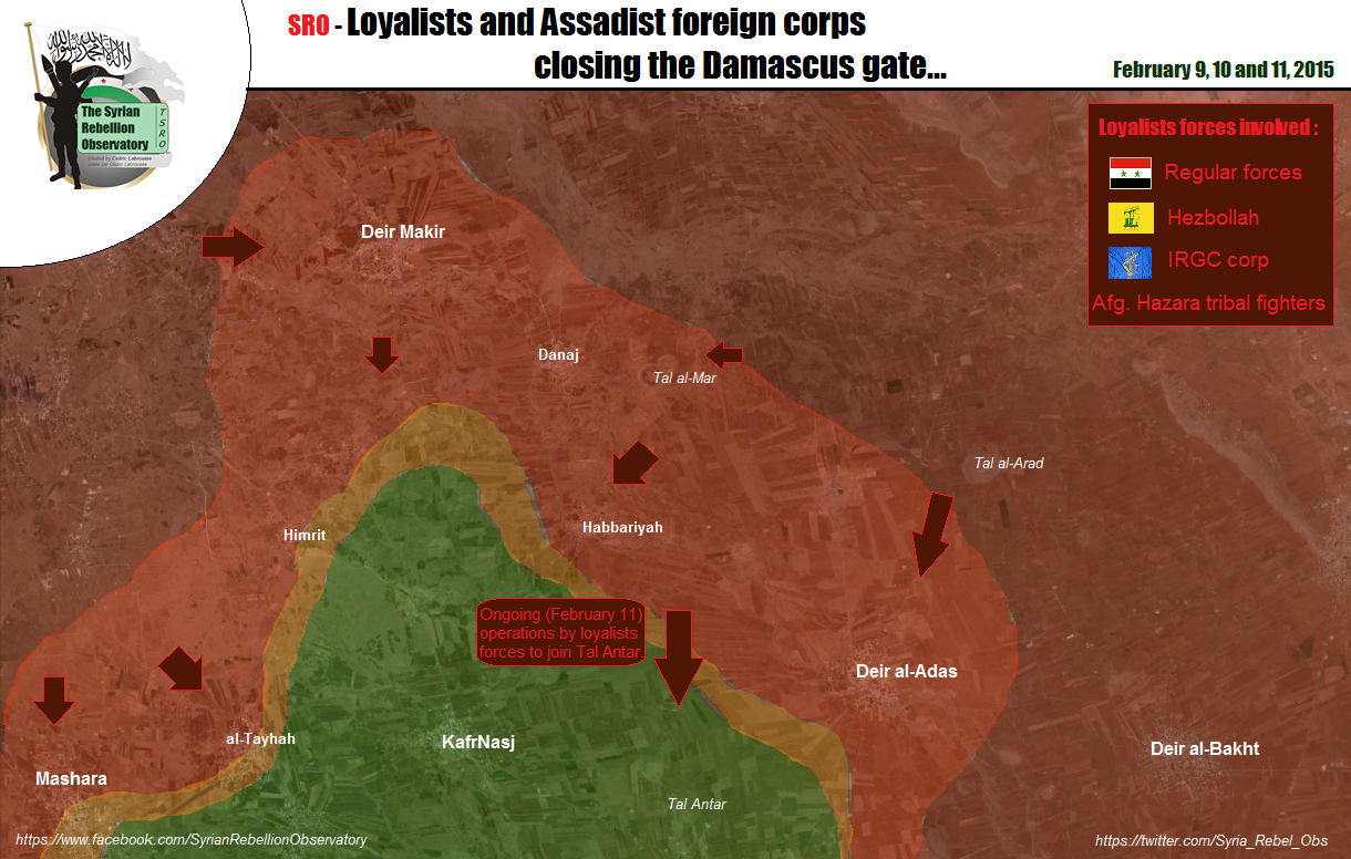
Hardatin
From SOHR fighting is still ongoing around Hardatin. Should we mark it with a red half ring? Paolowalter ( talk) 20:03, 22 February 2015 (UTC)
- Perhaps you are right! Hanibal911 ( talk) 20:52, 22 February 2015 (UTC)
SAA frontlines are still around Bashkuy and Dweir-AlZeitun..they`re not even close to Hrdatnin.the only change is that SAA recaptured northern part of Al-Malah farms yesterday while Malah village,southern Mallah and Arab-Sulum(between Handarat village and Arad Malah)totally under militants control..that`s the most recent update of frontlines.Rida Albasha (AlMayadeen reporter) is my friend,He informs me everything happens on the field neutrally every few hours via chat.If anyone wants confirmation,his news publishes in ElijahMagnier and many other credible pro/opp sources in twitter some hours later! — Preceding unsigned comment added by Xerxes92005 ( talk • contribs) 08:05, 23 February 2015 (UTC)
- @ Xerxes92005 We do need confirmation from published sources, but thanks for letting us know what to look for. If you can find published references, could you post them with your comments ? Thanks . André437 ( talk) 05:08, 24 February 2015 (UTC)
villages of Tehama ,Takleb ... #YPG advance
https://twitter.com/ColdKurd/status/569532093266587648 — Preceding unsigned comment added by Creepz55 ( talk • contribs) 16:36, 22 February 2015 (UTC)
Pro-kurdish source can't be used to show YPG advances. DuckZz ( talk) 16:38, 22 February 2015 (UTC)
- Agreed with DuckZz need data from neutral source. Hanibal911 ( talk) 16:53, 22 February 2015 (UTC)
Here is the location of the three claimed villages:
https://twitter.com/yunus4akca7/status/569568104411480064
According to local pro-govr source clashes are happening in the area between YPG and its al-Karama militia against Islamic State:
Enough for at least putting the villages in the map as contested?
186.116.23.131 ( talk) 18:49, 22 February 2015 (UTC)
- I think that it's enough, also reliable source https://twitter.com/EjmAlrai/status/569490519677661184 is confirming the clashes there -- 8fra0 ( talk) 19:12, 22 February 2015 (UTC)
http://www.reuters.com/article/2015/02/22/us-mideast-crisis-syria-iraq-idUSKBN0LQ0RG20150222?feedType=RSS&feedName=worldNews. Alhanuty ( talk) 21:14, 22 February 2015 (UTC)
- Here more data from pro opposition source about the Kurdish advances in Hasakah province near Iraqi border.
ARA News
Hanibal911 (
talk) 12:53, 23 February 2015 (UTC)
- Here reliable source reported that Kurdish forces and Syrian troops attacking ISIS between Jaz'a and Tel Hamid where over 25 villages were retaken from ISIS. And their aim is to reach Tel Hamid. Elijah J. Magnier Hanibal911 ( talk) 13:12, 23 February 2015 (UTC)
- Here more data from pro opposition source about the Kurdish advances in Hasakah province near Iraqi border.
ARA News
Hanibal911 (
talk) 12:53, 23 February 2015 (UTC)
- Note pro-govt almasdar also reported both forces are attacking ISIS but specified that this is not a joint operation, with SAA attacking the northern perimeter from their current positions northwest while the attacks between Jaz'a and Tal Hamis (as shown currently in the map) were carried out by kurdish forces: http://www.almasdarnews.com/article/isis-stronghold-tal-hamees-besieged-sides/ 186.116.23.131 ( talk) 14:06, 23 February 2015 (UTC)
- ANHA reports YPG liberated two more villages southwest of Jaz'ah. The villages are called Lesser and greater Qurtuba (Cordoba). Moreover, according to the source, clashes are continued near Ghasan village, some 24 km south of Ta Hamis.
http://ar.hawarnewsagency.com/%D8%AA%D8%AD%D8%B1%D9%8A%D8%B1-%D9%82%D8%B1%D9%8A%D8%AA%D9%8A%D9%86-%D9%88%D9%85%D9%82%D8%AA%D9%84-%D8%A3%D9%85%D9%8A%D8%B1-%D8%AA%D9%88%D9%86%D8%B3%D9%8A-%D8%AC%D8%AB%D8%AA%D9%87-%D8%A8%D9%8A%D8%AF/
Roboskiye (
talk) 16:25, 23 February 2015 (UTC)
- Also pro-ISIS sources confirm further YPG/Pesh advance in the area: https://twitter.com/mrasilh/status/569901576137121792
- ANHA reports YPG liberated two more villages southwest of Jaz'ah. The villages are called Lesser and greater Qurtuba (Cordoba). Moreover, according to the source, clashes are continued near Ghasan village, some 24 km south of Ta Hamis.
http://ar.hawarnewsagency.com/%D8%AA%D8%AD%D8%B1%D9%8A%D8%B1-%D9%82%D8%B1%D9%8A%D8%AA%D9%8A%D9%86-%D9%88%D9%85%D9%82%D8%AA%D9%84-%D8%A3%D9%85%D9%8A%D8%B1-%D8%AA%D9%88%D9%86%D8%B3%D9%8A-%D8%AC%D8%AB%D8%AA%D9%87-%D8%A8%D9%8A%D8%AF/
Roboskiye (
talk) 16:25, 23 February 2015 (UTC)
Some of the villages captured today by YPG in southeast and east of Tal Hamis are: http://ar.hawarnewsagency.com/%D8%AA%D8%AD%D8%B1%D9%8A%D8%B1-9-%D9%82%D8%B1%D9%89-%D9%81%D9%8A-%D8%B1%D9%8A%D9%81-%D9%82%D8%A7%D9%85%D8%B4%D9%84%D9%88/ Zahra: http://wikimapia.org/#lang=en&lat=36.583503&lon=41.434121&z=16&m=b Zahran: http://wikimapia.org/#lang=en&lat=36.641255&lon=41.579089&z=16&m=b Gassan: http://wikimapia.org/#lang=en&lat=36.549100&lon=41.420412&z=19&m=b Homs: http://wikimapia.org/#lang=en&lat=36.596341&lon=41.473694&z=18&m=b Hulwa: http://wikimapia.org/#lang=en&lat=36.803746&lon=41.588815&z=18&m=b Tal Tahin: http://wikimapia.org/#lang=en&lat=36.812514&lon=41.600064&z=17&m=b Roboskiye ( talk) 10:26, 24 February 2015 (UTC)
ISIS advances against Kurds in Tall Tamer countryside
Pro opposition source reported that ISIS captured village of Tall Shamiram after clashes against YPG. Qasion news and that ISIS kill civilians and burn the Ashuryan Church in the town of Tall Tamer. Qasion news SOHR also reported that ISIS captured village of Ghabshah. SOHR Hanibal911 ( talk) 13:28, 23 February 2015 (UTC)
- According to ANHA, YPG is fighting in and around Ghibish and Tal Shamiran villages. The villages are not fully under ISIS jihadi's control and should be changed to contested.
http://ar.hawarnewsagency.com/%D8%AA%D8%AD%D8%B1%D8%B1-%D8%A7%D9%84%D8%B9%D8%B4%D8%B1%D8%A7%D8%AA-%D9%85%D9%86-%D8%A3%D8%A8%D9%86%D8%A7%D8%A1-%D9%82%D8%B1%D9%8A%D8%A9-%D8%BA%D9%8A%D8%A8%D8%B4/
Roboskiye (
talk) 19:14, 23 February 2015 (UTC)
-
Roboskiye According to the rules of editing we cant use pro-Kurdish source in this issue and we cant marked villages of Ghibish and Tal Shamiran as contested we need confirmation from neutral source.
Hanibal911 (
talk) 19:58, 23 February 2015 (UTC)
- Reliable source reported that YPG now fighting against ISIS in the village of Khabur. Elijah J. Magnier and Syrian air force is also targeting ISIS convoy which heading toward the same area. Elijah J. Magnier Hanibal911 ( talk) 20:13, 23 February 2015 (UTC)
-
Roboskiye According to the rules of editing we cant use pro-Kurdish source in this issue and we cant marked villages of Ghibish and Tal Shamiran as contested we need confirmation from neutral source.
Hanibal911 (
talk) 19:58, 23 February 2015 (UTC)
- Pro-regime source claims NDF controls village of Khaza’at north of Tal Hamees. It also states YPG fighting in villages of Taweel, Al-Zaaqat, and Amnat.
It claims regime forces come from north to liberate Tal Hamees, while ypg coming from south to also liberate Tal Hamees. http://www.almasdarnews.com/article/isis-stronghold-tal-hamees-besieged-sides/ — Preceding unsigned comment added by 169.231.150.148 ( talk) 22:44, 23 February 2015 (UTC)
Also many many reports now online of assyrian militias in the area mobilizing.. and beheaders attacking assyrian civilians,women & children. Not sure if assyrians are working with kurds or damascus government?
Official statement of Syriac Military Council https://twitter.com/kovandire/status/569955779652014080 citing at least two other villages captured by IS today( Tel Hourmiz and Tel Tawil) that should be changed to black on map , but the same source says there are many others ...I think a large number of the Khabour River villages are now in IS hands...and about Tel Tamer itself: is it contested? Many reports of fighting inside the town, though not from a major source... Fab8405 ( talk) 23:52, 23 February 2015 (UTC)
I don't know if this is a reliable source, sure is not pro-IS...this map pretend to show the 10 villages on the Khabour River captured today by IS...if it's accurate, the villages should be Tal Tawil, Tal Shamiran( already edited), Tal Talla, Abu Tina, Tel Quran, Qabr Shamiya, Kharitha, Tal Makhatha, Tal Taal, Tal Hurmiz...here is the map, decide you what use to do of it https://twitter.com/rConflictNews/status/569988674064154624 Fab8405 ( talk) 00:33, 24 February 2015 (UTC)
-
Fab8405 This map
here from the reliable source.
le_carabinier
Hanibal911 (
talk) 10:16, 24 February 2015 (UTC)
- Pro opposition source reported that Syrin troops to support YPG sent three tanks from Qamishli to Tel Tamer.
Hasakah News
Hanibal911 (
talk) 10:21, 24 February 2015 (UTC)
- Pro Kurdish source reported that Syriac Military Council(MFS), Peoples Protection Units(YPG) and the Khabour Guards recaptured village of Agbish to west of Tel Tamer.
Syrian International News Agency
Hanibal911 (
talk) 11:40, 24 February 2015 (UTC)
- Here another source confirmed that YPG, Syriac Military Council(MFS) and Assyrian fighters recaptured village Agbish to west of Tall Tame. jack Shahine Hanibal911 ( talk) 18:19, 24 February 2015 (UTC)
- Pro Kurdish source reported that Syriac Military Council(MFS), Peoples Protection Units(YPG) and the Khabour Guards recaptured village of Agbish to west of Tel Tamer.
Syrian International News Agency
Hanibal911 (
talk) 11:40, 24 February 2015 (UTC)
- Pro opposition source reported that Syrin troops to support YPG sent three tanks from Qamishli to Tel Tamer.
Hasakah News
Hanibal911 (
talk) 10:21, 24 February 2015 (UTC)
YPG/FSA advance towards Tall Abyad
Sources https://twitter.com/markito0171/status/570270448048574465 are suggesting that YPG/FSA have taken this village http://wikimapia.org/#lang=it&lat=36.656370&lon=38.781910&z=13&m=b , just 15 km west of Tall Abyad. Let's wait for more confirmations. -- 8fra0 ( talk) 17:49, 24 February 2015 (UTC)
- ANHA reports Biyadiya west of Kobani is captured: http://ar.hawarnewsagency.com/%D8%AA%D8%AD%D8%B1%D9%8A%D8%B1-%D9%82%D8%B1%D9%8A%D8%A9-%D8%A8%D9%8A%D8%A7%D8%AF%D9%8A%D9%87/ Roboskiye ( talk) 21:57, 24 February 2015 (UTC)
Official Kataib Shamal page (FSA) said the same, "Their group captured Judajdah". DuckZz ( talk) 22:18, 24 February 2015 (UTC)
- Also earlier some reliable sources reported that the joint forces (YPG and rebels) captured 19 villages in Raqqa province. The Daily Star Al Joumhouria SOHR ABC.net Al Arabiya Hanibal911 ( talk) 22:34, 24 February 2015 (UTC)
identify Dabiq
Since the town of Dabiq figures prominently in ISIS myth and destiny your map should reflect its exact location and footnote the religious, political, historical and millennial significance of the town. Your well read visitors will appreciate the attention drawn to this site as an area seen by ISIS as critical to its own future. — Preceding unsigned comment added by 100.36.116.81 ( talk) 17:46, 23 February 2015 (UTC)
YPG advance in Qamislo
ANHA (kurdish source) states that YPG has taken 22 villages from ISIS in south Qamislo here: https://twitter.com/dilkocer/status/569402740016877568 . Can anybody confirm this news? -- 8fra0 ( talk) 09:14, 22 February 2015 (UTC)
-
8fra0 The data in this source
Cahida Dêrsim taken from pro Kurdish sources
ANHA Hawar News Agencyand
ANF News and we cant use this data because according to the rules of editing we cant use pro Kurdish sources to display success of Kurds. Need confirmation from neutral source.
Hanibal911 (
talk) 11:32, 22 February 2015 (UTC)
- Hanibal911 that's why I've written here before editing the map, looking for neutral sources. -- 8fra0 ( talk) 14:32, 22 February 2015 (UTC)
Sources are also reporting about a Peshmerga/YPG joint attack to villages near the border in east Hasakah: https://twitter.com/EjmAlrai/status/569490519677661184 -- 8fra0 ( talk) 14:35, 22 February 2015 (UTC)
Confirmed by SOHR, so the villages mentioned before can be edited I think. http://syriahr.com/en/2015/02/ypg-takes-control-over-20-villages-and-farmlands-in-al-hasakah/ -- 8fra0 ( talk) 15:01, 22 February 2015 (UTC)
- Another time SOHR inform about progres in this area without name of village. This same situation half month ago, when SOHR inform about SAA advance in this area (
217.99.151.213 (
talk) 15:51, 22 February 2015 (UTC))
-
8fra0 So for now I understand you just provide initial data from Kurdish source in order to we could look for more information on this subject based on your data! But now we have enough data from reliable sources that would edit the map.
Hanibal911 (
talk) 16:11, 22 February 2015 (UTC)
- Hanibal911 yes but I am not able to find those villages, if you know the correct positions you can add them. -- 8fra0 ( talk) 19:15, 22 February 2015 (UTC)
-
8fra0 So for now I understand you just provide initial data from Kurdish source in order to we could look for more information on this subject based on your data! But now we have enough data from reliable sources that would edit the map.
Hanibal911 (
talk) 16:11, 22 February 2015 (UTC)
Whoever edited the map got it wrong, the twenty liberated villages are around Xirbet Cihash not directly south of Qamishli.
186.116.23.131 ( talk) 18:13, 22 February 2015 (UTC)
- 186.116.23.131 I not make this editing on map but if you specify the right coordinates where these villages located I will correct this mistake. Hanibal911 ( talk) 18:59, 22 February 2015 (UTC)
- Hanibal911 You can find Taya and Mazluma here, with Tuwayl a bit to the southeast: http://wikimapia.org/#lang=en&lat=36.885937&lon=41.513214&z=12&m=b
- Cilbarat is here:
http://wikimapia.org/#lang=en&lat=36.817256&lon=41.682816&z=12&m=b
- 186.116.23.131 ( talk) 02:08, 23 February 2015 (UTC)
- According to ANHA, YPG liberated three villages southwest of Jaz'ah. The villages are: Xezaa (Khaz'ah), Selîma (Salim), Temîm (Tamim). http://ku.hawarnewsagency.com/li-cezaaye-3-gund-hatin-rizgarkirin/ Roboskiye ( talk) 20:12, 22 February 2015 (UTC)
Here is Khaz'ah on the map. Salim and Tamim are to the right of this village. http://wikimapia.org/#lang=en&lat=36.582521&lon=41.666164&z=14&m=b&show=/30379066/Khaza-ah 46.239.121.121 ( talk) 22:48, 22 February 2015 (UTC)
From AlMasdar advances of SAA and YPG toward Tal Hamees. Khaz'ah is claimed to be under control of SAA, maybe is controlled by SAA and YPG. Paolowalter ( talk) 09:21, 23 February 2015 (UTC)
- ANHA reports more than a dozen of new villages are liberated northeast and southeast of Tal Hamis. http://ku.hawarnewsagency.com/li-til-hemis-u-qamislo-rezecalakiyen-bi-bandor/ http://ar.hawarnewsagency.com/%D8%AA%D8%AD%D8%B1%D9%8A%D8%B1-14-%D9%82%D8%B1%D9%8A%D8%A9-%D9%81%D9%8A-%D8%B1%D9%8A%D9%81%D9%8A-%D9%82%D8%A7%D9%85%D8%B4%D9%84%D9%88-%D9%88%D8%AA%D9%84-%D8%AD%D9%85%D9%8A%D8%B3/#prettyPhoto
- Some of the villages in northeast are:
Damerji: http://wikimapia.org/#lang=en&lat=36.827510&lon=41.473764&z=17&m=b Tal Qarsa: http://wikimapia.org/#lang=en&lat=36.833251&lon=41.436433&z=18&m=b Shura: http://wikimapia.org/#lang=en&lat=36.811668&lon=41.395508&z=17&m=b Safiya: http://wikimapia.org/#lang=en&lat=36.845562&lon=41.625862&z=19&m=b Khirbat Bagh: http://wikimapia.org/#lang=en&lat=36.834896&lon=41.647671&z=19&m=b
- Some of the villages in southeast of Tal Hamis are:
Tamim: http://wikimapia.org/#lang=en&lat=36.578437&lon=41.623421&z=16&m=b Wael: http://wikimapia.org/#lang=en&lat=36.567874&lon=41.542675&z=16&m=b Taglab: http://wikimapia.org/#lang=en&lat=36.564996&lon=41.524887&z=16&m=b Rabia: http://wikimapia.org/#lang=en&lat=36.550940&lon=41.475486&z=18&m=b Roboskiye ( talk) 09:33, 23 February 2015 (UTC)
Al-Masdar is unreliable,and there is not any known presense of SAA there. for the status of the villages to the north of Tal Hamis,what should be done. Alhanuty ( talk) 17:38, 23 February 2015 (UTC)
- Alhanuty in your world yes, but in real world AlMasdar in this area is more reliable than sohr and isis. From AlMasdar: North of Tal Hamees, the Syrian Arab Army - backed by the National Defense Forces - are gaining on Al-Husiniyyeh. Fierce clashes south of Tal Hamees at Al-Saleema between the #YPG and #ISIS - if the YPG can break-through here, Tal Hamees will be besieged. ( 217.99.76.209 ( talk) 18:50, 23 February 2015 (UTC))
- Any source that just echos regime sources without analysis is a regime source. Thus almasdar is a regime source. Saying otherwise is simply nonsense.
- SOHR is an independent source, not tied to any party. They may have a preferred outcome, but according to WP guidelines that does not disqualify a source from being reliable. Since SOHR has a record of criticizing human rights abuses by all sides, and reports advances of all parties, it was decided by consensus that SOHR is a neutral source. Almost all criticisms of inaccuracy of SOHR posts have been unfounded. Because of their process of confirmation, some posts have been outdated, but that is true of all sources. The recent failed advances by the regime north of Aleppo city is a good case in point.
- BTW, could editors leave a blank line between posts so they don't run into each other ?
André437 (
talk) 05:52, 24 February 2015 (UTC)
- Pro opposition source reported that according to data from Kurdish military sources YPG forces were able to control the villages of Ziyada, Himr, Himr Akash, Jel Parat, Jel Parat Saghira, Mirza, Khirbet Baghl, Hurriya, Megrinat, Bizuna, Khirbet Tair, Tawil, Taya, Cheleki, Mezra Abu Hassan Hayahi, Amoudi, Zarij, Fares, and Faresok. ARA News Hanibal911 ( talk) 08:50, 24 February 2015 (UTC)
- Sohr have multiple times shown his bias toward the coverage of the conflict calling an "Iranian Invasion" on Aleppo, or Assad the "child killer" its clearly editorial propaganta against the Syrian Goverment. The Aleppo Prison Breash and capture by the rebels was a MEGA flop. The lack of neutrality of Sohr have caused that many editors use it as a second rate RS. Now its used to corroborate Regime advances only or to add rebels advances but with another most reliable source. Andre remember that Wp its not a SOAPBOX, sohr have lost all its profesionall credibility also look at their main logo a FSA flag. Thats why I Ask again, what else its needed to show its bias??? 200.48.214.19 ( talk) 13:37, 25 February 2015 (UTC)
- @ 200.48.214.19 Maybe a few hard facts, besides what seems to be an error made over a year ago by many other sources as well as SOHR. The fact that SOHR uses the independence flag, and the regime the Bathist flag, is irrelevant. The importance is the accuracy of reporting, which is generally balanced and proves to be accurate.
- It is almost universally recognized that there is a considerable involvement of Iranian forces (and regular funerals in Iran of their losses), as well as Iranian training and support of outside militias. So if SOHR happens to mention that from time to time, that is not an indication of bias. Similarly for the killing of children : regime barrel bombs on civilians tends to do that. Your argumentation indicates that you have a strong pro-Assad-regime bias. Not surprising that you find neutral sources biased.
- BTW, the "soapbox" guideline refers to articles, not talk pages. André437 ( talk) 00:47, 26 February 2015 (UTC)
- Sohr its not a neutral source and its you strong FSA militancy that makes you see SOHR as a Neutral source. Every day you show your bias in most of your edits, this clearly show your hidden allegiance, the usage of the FSA flag its obviosly showing SOHR identification with the FSA and its ideology, way of fighting. etc. just like Syrian Perspective uses the SAA flag, SOHR uses the Green White black flag of the FSA. Hope you manage to understand this fact. There is no way SOHR should be considered a neutral source in terms of information. Since it have shown heavy bias in the way they cover the Ongoign fighting, especially after the Battle of Yabroud/al Qusayr defeat of FSA and JAN. The neutral way sohr reported their entries changed dramatically, their daily casualties report in facebook changed and the propaganda campaign they made for their combatants in the field become viral. Clearly inflamatorial editorial likes, Iranian Siege of Aleppo or the ridicolous Aleppo Prison mega Flop, show the lack of profesionalism and made more than one to think that their are Economically hired by some rebels entitys, or maybe are the same Rebel entity propaganda organ. 200.48.214.19 ( talk) 15:29, 26 February 2015 (UTC)
http://ar.hawarnewsagency.com/%D8%AA%D8%AD%D8%B1%D9%8A%D8%B1-8-%D9%82%D8%B1%D9%89-%D9%88%D9%85%D9%86%D8%A7%D8%B7%D9%82-%D8%A7%D8%B3%D8%AA%D8%B1%D8%A7%D8%AA%D9%8A%D8%AC%D9%8A%D8%A9-%D9%81%D9%8A-%D9%85%D8%AD%D9%8A%D8%B7-%D8%AA%D9%84/. Alhanuty ( talk) 22:00, 26 February 2015 (UTC)
Lafarge Cement plant
There is information that ISIS blew up the Lafarge Cement plant after taking all that can be carried from it. here Also here the pro opposition source reported that ISIS destroyed Lafraj concrete factory. here So maybe we need remove the Lafarge Cement plant from map if he actually was destroyed. Hanibal911 ( talk) 21:05, 23 February 2015 (UTC)
- Well, even if in ruins (but we need a proof for that) I think that the factory can be left on the map: unfortunately many towns, oil wells, factories, military bases and facilites in Syria are destroyed nowadays, but it's not a good reason to erase them from the maps. -- 8fra0 ( talk) 09:47, 24 February 2015 (UTC)
- True, this will be specially important if YPG tries to put the plant back into work through international help or by themselves. 190.67.241.1 ( talk) 11:13, 24 February 2015 (UTC)
- The fact that a factory or base is in ruins constitutes a very good reason to erase it from the map given that there are already over 1500 icons on the map and it is creating severe computer problems for Wikipedia (not to mention it being misleading to our viewers). Those who have been around for long enough remember the time where we were very close to not being able to add any more icons on the map (before there was a very fortunate technical innovation in the code). Unfortunately, that day will come back again in the future. If the factory or base is put back into work and it is important, then we will hear about it from some source & put it back on the map.
Tradedia
talk 22:44, 24 February 2015 (UTC)
-
8fra0
Tradedia I hope you will agree with me that I did the right thing when remove from the map a Lafarge Cement plant. Because pro opposition source reported that ISIS blew up the plant after evacuating its contents and transferring them to the city of Raqqa and the blast led to the destruction of 80% of the plant.
ARA News So now it just ruins and there is no reason to keep it on the map as the cement plant.
Hanibal911 (
talk) 09:04, 26 February 2015 (UTC)
-
Tradedia
Hanibal911 I don't agree at all. Also Kobane is 80% destroyed, do we have to remove it also from the map? If the point is that there are some computing problems, then there are tens of insignificant and not strategic villages that can be removed. The Lafarge Cement factory is strategically important even if it is destroyed because it is near the frontline. --
8fra0 (
talk) 20:50, 26 February 2015 (UTC)
- 8fra0 You maybe dont see the differences between city and the factory. And also in the city still continue to live people and they busy restoration their homes. But from the cement plant ISIS removed all the equipment and his blew up. And now easier to re-build a new plant elsewhere. And also war still continues, and in the many Kurdish villages many homes was destroyed so that now is not the time to rebuild the cement plant. And now this factory it is just ruins. Hanibal911 ( talk) 22:39, 26 February 2015 (UTC)
-
Tradedia
Hanibal911 I don't agree at all. Also Kobane is 80% destroyed, do we have to remove it also from the map? If the point is that there are some computing problems, then there are tens of insignificant and not strategic villages that can be removed. The Lafarge Cement factory is strategically important even if it is destroyed because it is near the frontline. --
8fra0 (
talk) 20:50, 26 February 2015 (UTC)
-
8fra0
Tradedia I hope you will agree with me that I did the right thing when remove from the map a Lafarge Cement plant. Because pro opposition source reported that ISIS blew up the plant after evacuating its contents and transferring them to the city of Raqqa and the blast led to the destruction of 80% of the plant.
ARA News So now it just ruins and there is no reason to keep it on the map as the cement plant.
Hanibal911 (
talk) 09:04, 26 February 2015 (UTC)
- The fact that a factory or base is in ruins constitutes a very good reason to erase it from the map given that there are already over 1500 icons on the map and it is creating severe computer problems for Wikipedia (not to mention it being misleading to our viewers). Those who have been around for long enough remember the time where we were very close to not being able to add any more icons on the map (before there was a very fortunate technical innovation in the code). Unfortunately, that day will come back again in the future. If the factory or base is put back into work and it is important, then we will hear about it from some source & put it back on the map.
Tradedia
talk 22:44, 24 February 2015 (UTC)
Abu Kabira
It's really weird and ridicouls showing this village contested in that area when YPG captured more than 70 villages in Tel-Hamis area also this village is show near Tal Hamis. here, here. Lindi29 ( talk) 15:44, 25 February 2015 (UTC)
A side note in the same area. Should there be a border border post located on the IS held road between Mosul and Raqqa just south of Tel Hamis here http://wikimapia.org/#lang=en&lat=36.252303&lon=41.306190&z=12&m=b&show=/9795241/Iraqi-border-posts-on-the-Syrian-border-. MesmerMe ( talk) 17:37, 26 February 2015 (UTC)
- Remember that Daesh bulldozed the border, so as long as they still hold the area, it probably isn't occupied even if it is still there. Although kurdish forces report cutting the road, so maybe they will soon restore it. André437 ( talk) 01:54, 27 February 2015 (UTC)
- The berm was probably demolated by ISIS one way or another and it wasn't border post even before, but military post. Btw those 3 regime villages in middle of ISIS held territory - yeah, that is very likely. Like regime has any presence in Khabour valley, they are there because someone followed a facebook Assad fanpage which tells truth only when it makes a mistake and now it seems like regime controls whole southern Qamishlo, even though its non-sense. Oh, man, this getting sources for all those villages will take ages. EllsworthSK ( talk) 09:45, 27 February 2015 (UTC)
Villages apparently outside Syria marked
There are a number of villages that are shown as being beyond or right at the edge of the line used for the Syrian border such as Al-Hamman, Maydan, Ikbis, and a bunch near Kobane. Is this because there is a problem with the location map, or because they are marked incorrectly on this map? Banak ( talk) 11:09, 27 February 2015 (UTC)
- Could be either, as the wide line for the border should be centred on the border, but often editors make errors with the coordinates of locations.
- We should verify those on the border. André437 ( talk) 02:31, 28 February 2015 (UTC)
Northern Aleppo YPG - Rebels control line
May be some skilled editor could update the inactive front line between YPG controlled Afrin and rebels, between Turkish border and Nubl, based on my jan 22 map : [1]
The line of control is based on reliable information I got from a rebel fighter who stationed along that border 2 years ago. As there was no fighting between both parties for the lest 2 years, I think it is still OK. I noticed at least 2 names to change to green : Ziyara and Deir Jamal, but there may be others.
DeSyracuse ( talk) 15:04, 21 February 2015 (UTC)
What do you think who control the Minakh airbase ? Rebels or Al Nusra members ? — Preceding unsigned comment added by DuckZz ( talk • contribs) 17:24, 21 February 2015 (UTC)
- Minakh Air Base taken of Al Nusra after clashes against rebel group Northern Knights Brigades.
Al Monitor Also deSyracuse pro opposition and his data may be some times biased in favor the rebels. Still, maybe you're right about the villages Ziyara and Deir Jamal. But for greater certainty I think that we need search more data from neutral sources.
Hanibal911 (
talk) 18:19, 21 February 2015 (UTC)
- I understand the verification process although I deny to be pro-opp, but working on a historian approach of the conflict. In this case, I think the towns we talk about were originally put in yellow based on no reliable information, as well as the (now ISIS controlled) Al Ra'i kurdish pocket. Basically in this area, YPG holds the hights, and other rebels the plains. I just think this info would improve the accuracy of the map DeSyracuse ( talk) 04:15, 22 February 2015 (UTC)
Any update on the YPG advance in Kobani,especially inside Raqqa province. Alhanuty ( talk) 19:40, 21 February 2015 (UTC)
- Some, but YPG OPSEC follow 48 hours rule, only after that information is released to public. Other than that does probably not meet Wiki standards. EllsworthSK ( talk) 23:55, 21 February 2015 (UTC)
According to this guy with close links to jabhat al akrad he claims that Jabhat al akrad kurds controll tatmarash which is rebel held in this map. Also Deir jemal city is joint jabhat al akrad/YPG held but they let rebels use the countryside of deir jamal to target assad.
https://twitter.com/sergermed/status/560578422511259648 -- Creepz55 ( talk) 16:14, 22 February 2015 (UTC)
- @ Tradedia Why classify DeSyracuse as a "competitor" ? . Isn't it everyone's interest to convey accurate info of the situation on the ground ?
- BTW, unlike many editors here, I firmly believe that DeSyracuse is neutral. He also readily cooperates with other map producers and reporters on the Syrian conflict. We can only gain by cooperation .. my 2¢ ..
André437 (
talk) 05:24, 24 February 2015 (UTC)
- I classify him as a “competitor” because I cannot classify him as a “source”. A real source is a professional media organization. We don’t know anything about DeSyracuse other than that he has a twitter account and draws maps of the war.
We don’t know his real name, his qualifications or his methods. We don’t know if he is using sources or if he is guessing. He is an amateur map maker just like us. And I have no indication that he is better than us. He has been wrong many times before and we made our correct map wrong because we copied his mistakes.
Tradedia
talk 22:44, 24 February 2015 (UTC)
- you are free to use or not my maps. There is no map with no mistake as nobody, even what you call "professionnal media organization" don't have people on the ground on every front. In addition, I can tell you they very often release completely wrong maps, and when they issue close to reality maps, it's based upon one of the "amateur maps" such as mine or Archicivilians or Petolucem. For example, BBC did several times with my maps. Anyway, you talk about i've been wrong many times. Can you give me precise examples please ?
DeSyracuse (
talk) 10:55, 25 February 2015 (UTC)
- Our map was created to reflect reliable sources. It was not created to copy someone else's work. This is like if you are a student, instead of writing your exam on your own, you start copying from your neighbor’s exam sheet.
- There is a major difference between our map and your map. Our map marks towns (or bases, etc.) that we have information for. On the other hand, your map colors the whole Syrian territory assigning a control status to every area. Do you really have enough information to assign every area in the country to a specific party? What about close to empty areas? Do you have information to be able to draw the frontlines in these areas? Our map has started by marking all the towns for which we had information/sources. We did not have the aim to cover the whole Syrian territory. I prefer not to guess. If we don’t have reliable sources/information about an area, we should just leave it empty.
- I agree with you about "professional" maps. They are often approximate and this is normal as their readers are usually only interested in getting a general idea about the situation is Syria. The problem is not these professional maps or amateur maps (like yours). The problem is the attitude of some of our wikipedia map editors who think that maps from reliable sources are completely detailed and exact. So they end up copying them 100%, often overriding reliable sources that we already have about some locations. So they end up making our correct map wrong because they copied an approximate map. Also, some editors think that because an amateur map is classified as pro-rebel, it means that map is always correct for the towns that it marks as under gov control (and vice versa for pro-gov maps) However, this does not need to be the case, and we need to be examining all sources, instead of blindly copying someone else's map. For example, just because Peto Lucem is classified as pro-gov, does not mean all the rebel areas on his maps are correct. Many months ago, he had the area around Al-Tulaysiyah marked as rebel held (you can read all about it in the archives of this talk page). However, I was able to find a source that showed that in reality it was gov held. We informed Peto Lucem of his mistake and he corrected it. I don't fault Peto Lucem for making a mistake. I fault our editors for copying his mistake blindly without checking other sources. It is the same with any other internet map including yours.
- Yes, i can give you 2 recent examples off the top of my head where your map was wrong and we copied you and made our correct map wrong:
- 1- See Talk:Cities and towns during the Syrian Civil War/Archive 34#Abu al-duhur airbase
- 2- Your map dated 8-january-2015 shows Kafr Shams gov-held. This was before the large gov offensive (beginning february). So we know it was wrong since one of the gov offensive’s objectives was to capture Kafr Shams.
- So to summarize, for me, an internet Syria war map is not a “source” by Wikipedia standards.
Tradedia
talk 12:16, 26 February 2015 (UTC)
- OK I agree with what you say, so you should agree that my map and Wikipedia one are not competitors. But a few things I don't agree : there is no 100% reliable source. Even Sohr has sometimes wrong or uncomplete reports but is is used widely as a source on Wikipedia map. I'm not professionnal in the sense that I don't do business with that; however, I'm using a strict methodology that is based upon several sources, comparison method, terrain knowledge, and other informations. For instance an area which I am not sure is marked contested. Though I'm aware that is is no 100% accurate, but 100% accurate is not an objective in a dynamic war; Objective is to report on-going dynamics and strengths. As for Abu Duhur, I do not agree as those villages were Govt held the day when I drew the map; It was later abandonned and rebels took it back, so I always write the dates on my maps, it is important. For Kafr Shams, I agree for the mistake, but the original information showing Kafr Shams as govt controlled was not mine, as even Archicivilians and other (and Wikipedia) made the same mistake... So finally let us do our own job with our own methodology; no need to compete
DeSyracuse (
talk) 03:20, 27 February 2015 (UTC)
- 1- Concerning Abu Duhur, your map that had those villages Govt held was dated 8-december. However, the army had left the villages by November 28: Elijah J. Magnier and pro-gov detailed source. Elijah J. Magnier further explains that “SAA won't spread in an exposed area when the airport represents a better shelter and defense line”. You had marked the villages red based on: “On November 27, reports of Government troops coming from Abu Duhur base, seizing Humaymat”. This was widely publicized, especially by pro-gov generalist media. But you did not take into account the return of troops to the airport (28 Nov) which was reported only by a few well informed sources. In this case, we stumbled upon this information and used it. So on this specific instance, we were better than you. In other cases, I am sure you were better than us. My point is that we are both in the same kind of business: making maps based on sources. So we should not consider your maps as a source, and you should not consider our map as a source. This is what some of our editors don’t seem to understand… All they seem to care about is that you are classified as pro-rebel (not by me) and that this allows them to copy all your red towns without any thinking…
- 2- Concerning Kafr Shams, the fact that all maps had it wrong illustrates that a war map should not be a source. It is possible that one of the map makers “guessed” the status of this town without information/source and other map makers just copied his mistake… Tradedia talk 03:03, 28 February 2015 (UTC)
- OK I agree with what you say, so you should agree that my map and Wikipedia one are not competitors. But a few things I don't agree : there is no 100% reliable source. Even Sohr has sometimes wrong or uncomplete reports but is is used widely as a source on Wikipedia map. I'm not professionnal in the sense that I don't do business with that; however, I'm using a strict methodology that is based upon several sources, comparison method, terrain knowledge, and other informations. For instance an area which I am not sure is marked contested. Though I'm aware that is is no 100% accurate, but 100% accurate is not an objective in a dynamic war; Objective is to report on-going dynamics and strengths. As for Abu Duhur, I do not agree as those villages were Govt held the day when I drew the map; It was later abandonned and rebels took it back, so I always write the dates on my maps, it is important. For Kafr Shams, I agree for the mistake, but the original information showing Kafr Shams as govt controlled was not mine, as even Archicivilians and other (and Wikipedia) made the same mistake... So finally let us do our own job with our own methodology; no need to compete
DeSyracuse (
talk) 03:20, 27 February 2015 (UTC)
- you are free to use or not my maps. There is no map with no mistake as nobody, even what you call "professionnal media organization" don't have people on the ground on every front. In addition, I can tell you they very often release completely wrong maps, and when they issue close to reality maps, it's based upon one of the "amateur maps" such as mine or Archicivilians or Petolucem. For example, BBC did several times with my maps. Anyway, you talk about i've been wrong many times. Can you give me precise examples please ?
DeSyracuse (
talk) 10:55, 25 February 2015 (UTC)
- I classify him as a “competitor” because I cannot classify him as a “source”. A real source is a professional media organization. We don’t know anything about DeSyracuse other than that he has a twitter account and draws maps of the war.
We don’t know his real name, his qualifications or his methods. We don’t know if he is using sources or if he is guessing. He is an amateur map maker just like us. And I have no indication that he is better than us. He has been wrong many times before and we made our correct map wrong because we copied his mistakes.
Tradedia
talk 22:44, 24 February 2015 (UTC)
Semi-protected edit request on 26 February 2015
This
edit request to
Module:Syrian Civil War detailed map has been answered. Set the |answered= or |ans= parameter to no to reactivate your request. |
Can we please change the label size for Dabiq .... line 185 from 0 to 85 so that the name for that village shows up on the map. That town is center to ISIS religion and I had a very hard time finding it on the map. This will help others to locate it.
63.171.234.11 ( talk) 16:31, 26 February 2015 (UTC)
 Done Sort of ... displayed but not as large, since not enough room with all the other villages around it.
- Your comment makes me wonder, what should we call the ISIS/Daesh religion ? ... since it is obviously not islam, despite their pretensions.
André437 (
talk) 01:45, 27 February 2015 (UTC)
- Well it's Islam. Obviously not the same peaceful interpretation of Islam as the majority in the Islamic world share. But still it's some Muslims' interpretation of Islam. This New York Times article explains it best: http://www.nytimes.com/2014/10/09/opinion/bill-maher-isnt-the-only-one-who-misunderstands-religion.html Saeed alaee ( talk) 09:57, 27 February 2015 (UTC)
- Thus islam can be in gross violation of the Quran ?
- Thus somehow I was under the mistaken impression that the Quran was the essential basis of islam, supplemented by other sources such as the christian and jewish scriptures, as well as the hadiths of the various traditions.
- Note that some practices, such as hiding women or genital mutilation, are based on regional pre-islamic practices and not islam. Despite various propaganda, such practices are far from universal among muslim communities, and are not supported by the Quran. There is a difference between what some musulmans do, and what islam requires.
- BTW, the Quran in many places proposes freedom of religious belief, and is against aggression except in defense of others. Both grossly violated by ISIS/Daesh. As well as not following the Quran, they seem to have a new god ... André437 ( talk) 14:50, 27 February 2015 (UTC)
- There was a misunderstanding I think. I'm not saying their interpretation of Islam is what Islam actually is. I'm just saying they are Muslims because that's how they identify themselves. The guys who have joined ISIS are usually people who have become radicalized through their personal experiences; not because Islam by itself is radical("Jihadi John" is a good example in this case, apparently he was a victim of racism and mistreatment because of the fact that he was a Muslim back in U.K. so that radicalized him and eventually he ended up in ISIS). By the way I think it's important that we take into account that the doctrine behind this self-declared "caliphate" is a Salafi one. Also as an out-spoken atheist living in an Islamic society I of all people know that Muslims have an overwhelming majority who are peaceful, tolerant and respectful of different beliefs and faiths. Saeed alaee ( talk) 17:39, 27 February 2015 (UTC)
- In my view you could call it "false islam", but calling it "islam" tarnishes real muslims in the eyes of many totally unfamiliar with the faith. I've known and discussed religion with those of many faiths (christian/jewish/muslim/sikh/buddist/hindu and maybe others, not to exclude atheists and agnostics), and generally all groups are peace-loving and respectful of others beliefs. With evident small minorities of exceptions.
- I really hate to see non-muslims tarring billions of people as terrorists because of some deviant misfits and egomaniacs trying to build their little empire.
- In my mind, claiming you are a "genius" doesn't make you so. (Substitute anything for "genius".) ... my 2 cents ... André437 ( talk) 03:31, 28 February 2015 (UTC)
Daraa NW
Some more info from AlMasdar. Al-Habariya contested and maybe Tel also Qareen. Paolowalter ( talk) 07:52, 24 February 2015 (UTC)
- Paolowalter Source not said that the village of Al Habbariyah or hill of Tal Qareen contested. Source said that clashes between Syrian troops and Al Nusra at the Al Habbariyah when army from this village try advance to the hill Tal Qareen. And said that resulting Syrian troops advance to southwest area near of Tal Qareen. Al Masdar Hanibal911 ( talk) 10:07, 24 February 2015 (UTC)
- I saw a pro-regime twitter post stating that "SAA units carried out concentrated hits on terrorists pos. in AlHebarieh,KaferNasij,AlTeeha,Sabsaba & a# of hills on #Daraa - #Quneitra axis" I saw on the map that Al-Habbariyah and At Tayhah are regime held. Is the content and the source itself sufficient enough to say those two villages are contested?
Raspoetin89 — Preceding
unsigned comment added by
193.191.220.222 (
talk) 11:11, 26 February 2015 (UTC)
- Firstly you dont provide link on your source which said this and secondly more reliable pro government source reported that Syrian troops advanced to the outskirts of Tal Qareen from the town of Al-Habariyah. here and also earlier reliable source Elijah J. Magnier and pro opposition source Syrian Rebellion Observatory confirmed that the village of At Tayhah was captured by army. Hanibal911 ( talk) 11:29, 26 February 2015 (UTC)
- oops, sorry! Something went wrong probably while editing. This is the source I was talking about:
Damascus01 and
[3] I'm quite new here, so I have no idea how biased/important this source and Hosein Mortada are.
Raspoetin89
- Here data from the official government source. Army units carried out intensive operations against terrorist gatherings from several axes in the towns of al-Habbaria, Kafar Nasej, al-Teeha, Sabsaba and a number of hills.
SANA so I marked Al-Habbariyah and At Tayhah as contested.
Hanibal911 (
talk) 13:11, 26 February 2015 (UTC)
-
Raspoetin89 Done
Hanibal911 (
talk) 13:41, 26 February 2015 (UTC)
-
Raspoetin89
- Here data from the official government source. Army units carried out intensive operations against terrorist gatherings from several axes in the towns of al-Habbaria, Kafar Nasej, al-Teeha, Sabsaba and a number of hills.
SANA so I marked Al-Habbariyah and At Tayhah as contested.
Hanibal911 (
talk) 13:11, 26 February 2015 (UTC)
- oops, sorry! Something went wrong probably while editing. This is the source I was talking about:
Damascus01 and
[3] I'm quite new here, so I have no idea how biased/important this source and Hosein Mortada are.
Raspoetin89
- Report from
Al Manar that SAA and NDF have control of Himrit & Sultaniyah & Habbariyyah. Confirmation from pro fsa
[4] and
[5] and
[6]. Pro gov almasdar say about 5 town which have been secured
[7] and
[8]. It is mean Al-Habariyah, Tal Qareen, Sibsiba (sabsaba), Himrit and Al-Sultaniyah.
map (
217.99.142.150 (
talk) 09:55, 28 February 2015 (UTC))
- Some progres confirmation from neutral source
EjmAlrai
Kreen (
217.99.142.150 (
talk) 10:46, 28 February 2015 (UTC))
- Syrian troopsand Hezbollah captured Habarriyah
here and also Tall Qrein, Himrit and Tell Sultaniyah
Elijah J. Magnier and now fighting in the Tal al-Allakiya, Tal Samn Akraba, Simlin and pounding Kfar-nasej, Kfar Shams and tall al-Harra.
Elijah J. Magnier
Hanibal911 (
talk) 12:55, 28 February 2015 (UTC)
- SOHR also reported that Hezbollah backed by fighters from Iran and NDF have taken over Tell-Qareen, Al-Habariyah, Sultaniyah and Himrit. SOHR Hanibal911 ( talk) 13:06, 28 February 2015 (UTC)
- Syrian troopsand Hezbollah captured Habarriyah
here and also Tall Qrein, Himrit and Tell Sultaniyah
Elijah J. Magnier and now fighting in the Tal al-Allakiya, Tal Samn Akraba, Simlin and pounding Kfar-nasej, Kfar Shams and tall al-Harra.
Elijah J. Magnier
Hanibal911 (
talk) 12:55, 28 February 2015 (UTC)
- Some progres confirmation from neutral source
EjmAlrai
Kreen (
217.99.142.150 (
talk) 10:46, 28 February 2015 (UTC))
Suggest removing tiny sub-villages cluttering up the map
There are many hamlets of maybe 10 houses cluttering up the map. They have no military or strategic interest, even if they were at some time on or near the front lines. Hills near towns or cities or important highways might have strategic importance, but not these hamlets.
So I suggest that we remove all such points, and not add them in the future.
This came to my attention on investigation after a viewer questioned some villages placed outside Syria. Most of the dots I checked were not even big enough to be called a village.
I was looking in the Kobani area, but a similar density of dots appears in Daesh-controlled areas in northern Raqqa. This doesn't make much sense, since these areas are very sparsely populated. Many don't even have any roads on google maps, which means nothing more than dirt paths.
So what does everyone think ?
André437 (
talk) 04:38, 28 February 2015 (UTC)
- Same goes for SAA-held areas south of Qamishli and ISIS-held areas in E-Homs. ChrissCh94 ( talk) 08:50, 28 February 2015 (UTC)
Agree .pyphon — Preceding unsigned comment added by Pyphon ( talk • contribs) 12:10, 28 February 2015 (UTC)
In general I agree, some areas in the deset or on the mountans in the norther province are overrepresented. They are unlikely to be quoted when they change control, therefore they stick for ever bringing little informaton to the map. Paolowalter ( talk) 13:26, 28 February 2015 (UTC)
I disagree. When a major offensive occurs, we will then have to go to the trouble to find the villages, reach a consensus, and then re-add the villages, hoping we have the right coordinates. It is better to leave them where they are, because you never know when they might become of 'strategic interest'. For example, if the Syrian Army advances east of Homs, you will have to show that advance. If the villages north of Raqqa become contested, by the YPG or perhaps American-backed moderate Syrian rebels, you will have to show that on the map. It is for that reason that I think they should be left, even if they are only 10 houses. Besides, you can always physically decrease their mark size on the map. 2601:0:B200:F7D9:119F:7E70:9C28:7947 ( talk) 22:53, 28 February 2015 (UTC)
- I'd personally be a small marker in the place of small captured villages/building. If nothing else, it allows us to more accurately reflect the front-lines. Potential problem: people may edit war over what counts. Banak ( talk) 23:42, 28 February 2015 (UTC)
Tall Hamis
The capture town of Tel Hamis was announced by the Kurdish YPG militia and confirmed by the Syrian Observatory for Human Rights. Reuters Hanibal911 ( talk) 15:23, 27 February 2015 (UTC)
- Probably next target will be Tell Brak. According
PetoLucem SAA/NDF have captured important hills near IS held Tell Brak, located 20 miles NE of Al Hasakah
Brak (
217.99.142.150 (
talk) 17:55, 27 February 2015 (UTC))
- Peto Lucem likes to claim a lot of things that go widely unsourced. Interestingly enough according to regime fanpages "SAA" (which is nonexistent in Hasakah countryside) is heavily and steadily advancing south of Qamishlo (which someone who makes this map took bit too seriously), yet fails every time to produce one bit of an evidence. Both ISIS and Kurds release pics and vids of important areas they capture, Syrian state apparently relies on expats twitter feeds and facebook pages. Seriously, look at the Khabour. Accoring to them NDF holds 3 villages in middle of Daesh territory and no one bats an eye there. THey claimed how NDF was involved in patrolling Khabour valley and yet 0 NDF casualties and no one saw them anywhere. Regime "gains" in Hasakah are mostly bunch of hot air.
EllsworthSK (
talk) 18:08, 27 February 2015 (UTC)
- I remember when Serekaniye and Kobanê liberated y YPG from Islamists, the Syrian state media announced in both cases Our brave SAA with local support cleaned these cities.
Roboskiye (
talk) 19:53, 27 February 2015 (UTC)
- In the beginning, Assad regime claimed that YPG is part of NDF. So, that much for their credibility in North-East.
EllsworthSK (
talk) 19:59, 27 February 2015 (UTC)
- But in Quamishili area pro regime media said about ypg offensive in south, north and east area Tall Hamis. Theay only said about saa and ndf offensive in west area Tall Hamis. I see few tweet pro regime
[9]
Tal Satah and probably
Tal Ahmad,
[10] and
[11]. I agree and understand that be wait for confirmation for neutral source. But if it is confirmed, it means that the Tall Hamis can fall and ISIS disappear from Qamishli area (
217.99.142.150 (
talk) 20:59, 27 February 2015 (UTC))
- The fact that last tweet talks about 47th armored brigade which is based in Reef Dimashq and not Hasakah did not tip you off? Aside of that - some bloke writes something on twitter does not mean that we should take it any more seriously than anything else. There are virtually no evidences of Syrian regime presence in southern Qamishlo aside of Tayy tribe which simply inhabits its own villages and is allied with regime, nothing else. SAA in that region virtually ceased to exist, why else would just Daesh run over 121st artillery regiment base with the mighty SAA just watching over? Why else would SAA involvement in clashes with Kurds in Hasakah and Qamihslo would be on 0, instead only using NDF?
EllsworthSK (
talk) 21:07, 27 February 2015 (UTC)
- Right! The SAA/NDF does not exist there. It is just a BIG myth made up by the government, EJM, peto lucem, and Robert Fisk. Fisk's interview with soldiers there. Forget about it! No such thing. It probably took place in an upscale Damascus movie set. Come on guys, really. I though we agreed to stop the nonsense conspiracy theories after the "SAA=ISIS" one fell through.
XJ-0461 v2 (
talk) 21:23, 27 February 2015 (UTC)
- Meanwhile I just hope that your arm doesn´t hurt you from patting yourself on the back so much. Instead of climbing that horse so high, why won´t you simply start reading more properly. Fisk was in Qamishli city where NDF controls part of the city and SAA is in control of Qamishli airbase (base of one rotary Mi-17 sqn) and Tartab 154th artillery regiment base. And that proves that SAA now controls area near Tall Brak. Why? Because you are reading a bloke on twitter which fails time and again to provide any kind of solid source for these claims. If at least state media would announce it, but no, we are now contempt with Peto Lucem and google translated snippets on twitter from facebook fan page. Just great. But if you want to entertain me, provide me any kind of source that says that SAA/NDF controls, say, Jiha Saghirah which is in middle of Kurdish inhabited area, outside of Tayy or Shammar. EllsworthSK ( talk) 21:42, 27 February 2015 (UTC)
- Oh, yes, and again. Who is doing all that "liberation". Damascus armored division. Magically teleporting itself more than 1k kilometers there and back. Sounds solid.
EllsworthSK (
talk) 21:47, 27 February 2015 (UTC)
- EllsworthSK you forgot about wikipedia map half years ago in Qamishli area? SAA was only near Qamishli city and military base. Suddenly visited foreign journalists and it turned out that the area controlled by the SAA was increesed to 22 miles and nobody informed about it. In this area there are not too many sources because this area is not attractive for journalists. Many small village, not too many people and not too many ISIS fighters etc. Look ypg or saa start offensive and they can take control for 10 village per day. Tall Hamis fall in few hours. If they attack Tall Brak it will fall mayby in one day.( 217.99.142.150 ( talk) 21:59, 27 February 2015 (UTC))
- Right! The SAA/NDF does not exist there. It is just a BIG myth made up by the government, EJM, peto lucem, and Robert Fisk. Fisk's interview with soldiers there. Forget about it! No such thing. It probably took place in an upscale Damascus movie set. Come on guys, really. I though we agreed to stop the nonsense conspiracy theories after the "SAA=ISIS" one fell through.
XJ-0461 v2 (
talk) 21:23, 27 February 2015 (UTC)
- The fact that last tweet talks about 47th armored brigade which is based in Reef Dimashq and not Hasakah did not tip you off? Aside of that - some bloke writes something on twitter does not mean that we should take it any more seriously than anything else. There are virtually no evidences of Syrian regime presence in southern Qamishlo aside of Tayy tribe which simply inhabits its own villages and is allied with regime, nothing else. SAA in that region virtually ceased to exist, why else would just Daesh run over 121st artillery regiment base with the mighty SAA just watching over? Why else would SAA involvement in clashes with Kurds in Hasakah and Qamihslo would be on 0, instead only using NDF?
EllsworthSK (
talk) 21:07, 27 February 2015 (UTC)
- But in Quamishili area pro regime media said about ypg offensive in south, north and east area Tall Hamis. Theay only said about saa and ndf offensive in west area Tall Hamis. I see few tweet pro regime
[9]
Tal Satah and probably
Tal Ahmad,
[10] and
[11]. I agree and understand that be wait for confirmation for neutral source. But if it is confirmed, it means that the Tall Hamis can fall and ISIS disappear from Qamishli area (
217.99.142.150 (
talk) 20:59, 27 February 2015 (UTC))
- In the beginning, Assad regime claimed that YPG is part of NDF. So, that much for their credibility in North-East.
EllsworthSK (
talk) 19:59, 27 February 2015 (UTC)
- I remember when Serekaniye and Kobanê liberated y YPG from Islamists, the Syrian state media announced in both cases Our brave SAA with local support cleaned these cities.
Roboskiye (
talk) 19:53, 27 February 2015 (UTC)
- Peto Lucem likes to claim a lot of things that go widely unsourced. Interestingly enough according to regime fanpages "SAA" (which is nonexistent in Hasakah countryside) is heavily and steadily advancing south of Qamishlo (which someone who makes this map took bit too seriously), yet fails every time to produce one bit of an evidence. Both ISIS and Kurds release pics and vids of important areas they capture, Syrian state apparently relies on expats twitter feeds and facebook pages. Seriously, look at the Khabour. Accoring to them NDF holds 3 villages in middle of Daesh territory and no one bats an eye there. THey claimed how NDF was involved in patrolling Khabour valley and yet 0 NDF casualties and no one saw them anywhere. Regime "gains" in Hasakah are mostly bunch of hot air.
EllsworthSK (
talk) 18:08, 27 February 2015 (UTC)
-
EllsworthSK I do not understand your logic. I was starting discussion about Tall Brak area and now you talk about all syria and other tweet in other Syria regions. Nothing has been changed, I only drew attention to the offensive saa in this region and I am waiting for confirmation from the other neutral sources (
217.99.142.150 (
talk) 22:08, 27 February 2015 (UTC))
- EllsworthSK When pro-opp and pro-ISIS confirm that it is a joint offensive on Tall Brak [12] [13] [14] [15] ChrissCh94 ( talk) 23:40, 27 February 2015 (UTC)
Pro-Kurdish reporter says that YPG is preventing government forces to join them. Same said by the kurdish reporter
- None of the reports above say that regime forces actually entered Tall Brak (with the YPG), although some say they intended to, and others say they (with the YPG) were advancing in the area. As well as the 2 posts just above, other reports e.g. say that the YPG blocked access of regime forces to the town. André437 ( talk) 04:33, 28 February 2015 (UTC)
Andre437 yes that is correct but EllsworthSK is suggesting that the SAA are not involved in the offensive which can not be true if YPG have barred them from entering the town .Reports of joint offensive and the fact that if barred from entering the town must mean they are nearby . Pyphon ( talk) 11:43, 28 February 2015 (UTC)pyphon
Tall Brak and its neighbouring villages was turned yellow with very weak sources. Can we calim for sure that ISIS does not control them anymore and SAA does not controle them either? Paolowalter ( talk) 16:24, 28 February 2015 (UTC)
Pro-opp source confirming SAA advance in Hasaka https://twitter.com/archicivilians/status/571695911719473152. It does not state precisely where. Original source speaks about south of Qamishli Paolowalter ( talk) 16:30, 28 February 2015 (UTC)
Pro-SAA source stating YPG is in control of Tal Brak while SAA controls Bahiyah to the southwest: https://twitter.com/SyrianLion_/status/571704498260992000
186.119.189.150 ( talk) 16:47, 28 February 2015 (UTC)
According to pro-Islamic State source
https://www.facebook.com/permalink.php?story_fbid=1632426480323380&id=1418222505077113 clashes ongoing near Tal Brak in Tal Faras N of the city and this village which despite being roughly the size of Tal Brak is not marked in the map:
http://wikimapia.org/#lang=en&lat=36.708958&lon=41.102858&z=14&m=b
Tal Faras is already marked as yellow but I would suggest putting it contested too, along with the other.
186.119.189.150 ( talk) 17:30, 28 February 2015 (UTC)
I do not understand logic - using biased pro kurd source to show progress ypg and in this same time ignor pro gov and pro rebel source saying about saa offensive in this same region. It is very easy here to change black dots to yellow ( 217.99.113.146 ( talk) 19:11, 28 February 2015 (UTC))
Pro-govt media has stated SAA captured the following villages, near Tawarij area south of Qamishli: https://www.facebook.com/SyrianArabNewsAgencySana/posts/888252777863917
If you can provide coordinates they can be marked in the map.
186.119.189.150 ( talk) 20:18, 28 February 2015 (UTC)
Also in https://twitter.com/search?q=%23hasakah&src=typd there are a list of villages taken by SAA and http://english.farsnews.com/newstext.aspx?nn=13931209000428 there is a list of viallges taken by SAA. Paolowalter ( talk) 21:36, 28 February 2015 (UTC)
Also Al Masdar reports some villages taken by SAA. Di Paolowalter ( talk) 09:33, 1 March 2015 (UTC)d anybody locate them?
It seems that whenever YPG and its Assyrian and Arab allies gain a victory over ISIL the Assadists try to push themselves in and make out as if it was a joint operation. BTW, it's very very very unlikely that Coalition airstrikes would be supporting an operation in favor of SAA. Saeed alaee ( talk) 21:27, 28 February 2015 (UTC)
Saeed alaee there are many sources from all sides that say YPG and SAA are in joint offensive against ISIS and as for airstrikes they are targeting JAN in Aleppo also which will obviously help SAA . Pyphon ( talk) 21:49, 28 February 2015 (UTC)PYPHON
According pro rebel map archicivilians many of villages in Qamishili area is still controling by ISIS and SAA progress in this area is not false ( 217.99.113.146 ( talk) 23:39, 28 February 2015 (UTC))
- Name of liberated village by saa almasdar Farfarat, Tal Ahmad, Khirbat Noura, Tafeehiyah, Khaznat, Sawama’ Al-Tawareej, Bayzari, Khirbat Zouman, Tal Assoud, Maqbrat Tal Assoud, Al-Bwaab, Tal Al-Fawqaani, and Tal Hamza. ( 217.99.113.146 ( talk) 09:31, 1 March 2015 (UTC))
Many ISIS controlled locations were removed with little support from the sources. I guess that the lack of ISIS supporter between the editors has obscured out quest for reliability. We should review all recent changes and see which are reliable and which not. Furthermore many quick switch to yellow was done on purpose to avoid setting some of them red. Paolowalter ( talk) 09:33, 1 March 2015 (UTC)
SOHR confirms advance of SAA in Hasaka http://syriahr.com/en/2015/03/is-beheads-a-defected-first-lieutenant-in-deir-ezzor-while-the-regime-troops-retake-some-villages-in-al-hasakah/ on the road between Tal-brak and al-Qameshli. Paolowalter ( talk) 09:39, 1 March 2015 (UTC)
Daraa
According to SOHR arabic SAA captured tell qareen , habbariyah ,tell sultaniyah ,khirbet sultaniyah and himrit source: http://www.syriahr.com/2015/02/%D8%AD%D8%B2%D8%A8-%D8%A7%D9%84%D9%84%D9%87-%D8%A7%D9%84%D9%84%D8%A8%D9%86%D8%A7%D9%86%D9%8A-%D9%8A%D8%B3%D9%8A%D8%B7%D8%B1-%D8%B9%D9%84%D9%89-4-%D8%A8%D9%84%D8%AF%D8%A7%D8%AA-%D9%88%D9%82%D8%B1%D9%89/ Hwinsp ( talk) 11:36, 28 February 2015 (UTC)
Also document sy confirmed SAA captured tell qareen , habbariyah ,tell sultaniyah ,khirbet sultaniyah and himrit: https://www.facebook.com/documents.sy/posts/901068736622550 https://www.facebook.com/documents.sy/posts/901063536623070 Hwinsp ( talk) 11:40, 28 February 2015 (UTC)
Al Masdar http://www.almasdarnews.com/article/syrian-army-hezbollah-advances-towards-rebel-held-daraa/ reports that Himrit, Al-Sultaniyah, Sibsiba and 5 villages altogether have been captured by SAA. Paolowalter ( talk) 13:09, 28 February 2015 (UTC)
Pro rebel source confirm that Thomas van Linge about Himrit, Sultaniyah and Sabsabah ( 83.26.142.133 ( talk) 13:38, 28 February 2015 (UTC))
SOHR for Hamrit and Sasba http://syriahr.com/en/2015/02/7-rebels-killed-by-clashes-against-hezbollah-in-reef-dimashq/ as well. Paolowalter ( talk) 13:53, 28 February 2015 (UTC)
- Here another reliable source reported that Syrian troops controlled Tall Qrein, Himrit and Tell Sultaniyah Elijah J. Magnier and now fighting in the Tal al-Allakiya, Tal Samn, Akraba, Simlin and pounding Kfar-nasej, Kfar Shams and tall al-Harra. Elijah J. Magnier Hanibal911 ( talk) 14:16, 28 February 2015 (UTC)
According to The statement of the General Command of the Armed Forces (SAA) SAA also captured tell al fatimah source: https://www.facebook.com/video.php?v=581994665236472&set=vb.236781613091114&type=2&theater Hwinsp ( talk) 17:48, 28 February 2015 (UTC)
Thas is supported also by the new Petolucem map https://twitter.com/PetoLucem/status/571759910653992960. Paolowalter ( talk) 21:51, 28 February 2015 (UTC)
sohr arabic confirmed , tell al fatimah and sabsaba under saa control : http://www.syriahr.com/2015/03/%D8%AD%D8%B2%D8%A8-%D8%A7%D9%84%D9%84%D9%87-%D8%A7%D9%84%D9%84%D8%A8%D9%86%D8%A7%D9%86%D9%8A-%D9%88%D8%A7%D9%84%D9%82%D9%88%D8%A7%D8%AA-%D8%A7%D9%84%D8%AF%D8%A7%D8%B9%D9%85%D8%A9-%D9%84%D9%87-%D9%8A/ Hwinsp ( talk) 22:46, 28 February 2015 (UTC)
- Syrian troops and Hezbollah catured Tall Qrein, Tell al Fatimah, Al Habbariyah, Himrit, Sebsaba and Kherbet Sultaniyah.
SOHR
Hanibal911 (
talk) 11:25, 1 March 2015 (UTC)
- Reliable source reported that Syrian troops and Hezbollah are advancing toward Tal al-Harra (at 10km) after capturing the hills overlooking it in the reef Daraa. Elijah J. Magnier and that and that Syrian troops and Hezbollah captured Rajm al-Sayed, situated/overlooking on Hemreet, Kfar-Nasej, Tal el-Mal, Mashara, Nab'e al-Sakhr and Umm Batna. Elijah J. Magnier Hanibal911 ( talk) 13:30, 2 March 2015 (UTC)
- Syrian troops and Hezbollah catured Tall Qrein, Tell al Fatimah, Al Habbariyah, Himrit, Sebsaba and Kherbet Sultaniyah.
SOHR
Hanibal911 (
talk) 11:25, 1 March 2015 (UTC)
Rajm AlSayd
From https://twitter.com/Damascus_01/status/571975879305404416 Rajm AlSayd was taken by SAA. Where is this town? Paolowalter ( talk) 20:28, 1 March 2015 (UTC)
- Paolowalter it is village of Rasm al Sayd and he is already on the map near village of Mamtinah in Quneitra. But this data from pro government source and we cant use him for display the success Syrian troops. But on the basis of these data we can try find in reliable sources another confirmations of these data. Hanibal911 ( talk) 20:53, 1 March 2015 (UTC)
Rasm al Sayd is located on the map at coordinates lat = 33.094, long = 35.909 and Rasm al Kharrar at coordinates lat = 33.091, long = 35.926, those places in wikimapia poin to http://wikimapia.org/#lang=it&lat=33.094000&lon=35.909000&z=14&m=b and http://wikimapia.org/#lang=it&lat=33.091000&lon=35.926000&z=14&m=b. Those positions are not obviously associated to villages. There are close Rasm al Halabai at lat = 33.093 and lon = 35.891 and Rasm al-Khawalid at lat = 33.113 and lon = 35.911. Does anybody understand the situation? Paolowalter ( talk) 21:23, 1 March 2015 (UTC)
- Paolowalter Here on map Rasm al Sayd Rasm al Halabi Rasm al Kharrar Hanibal911 ( talk) 22:09, 1 March 2015 (UTC)
Confirmed by Al Masdar but the location seems not to correspond to what we see on the map. I am puzzled. Paolowalter ( talk) 08:04, 2 March 2015 (UTC)
Rasm al sayd location acording to saa source: https://www.facebook.com/syriafutureagency/photos/pb.1416705415237221.-2207520000.1425287218./1577522569155504/?type=3&theater LOCATION : http://wikimapia.org/#lang=tr&lat=33.145241&lon=35.997562&z=13&m=b&gz=0;360088062;331574572;71239;71851;0;24789;79822;718;114154;5029;152778;57122;68664;71851 195.155.234.12 ( talk) 09:07, 2 March 2015 (UTC)
-
195.155.234.12 You source said about Tel Hunter but not abou Rasm al sayd. You need to be carefully read your source.
Hanibal911 (
talk) 12:45, 2 March 2015 (UTC)
- Reliable source reported that Syrian troops and Hezbollah are advancing toward Tal al-Harra (at 10km) after capturing the hills overlooking it in the reef Daraa. Elijah J. Magnier and that and that Syrian troops and Hezbollah captured Rajm al-Sayed, situated/overlooking on Hemreet, Kfar-Nasej, Tal el-Mal, Mashara, Nab'e al-Sakhr and Umm Batna. Elijah J. Magnier Hanibal911 ( talk) 13:20, 2 March 2015 (UTC)
Hannibal they are same , source says ' Syrian army controls the Rasm al sayd area known as the Tel hunter. Rasm al sayd = Tel Hunter :) Hwinsp ( talk) 13:41, 2 March 2015 (UTC)
- Hwinsp SANS said that Rajm al-Sayd also known as Tal al-Sayyad located in the southwestern countryside of Damascus between Kafr Nasij and and Himri. SANA So that according to data from the pro government sources here here and data from a reliable source here I add this is object to map. Hanibal911 ( talk) 14:13, 2 March 2015 (UTC)
Rif Al Hasakeh Change
the news confirmed that these villages were captured by SAA during YPG advances in east of Hasakeh
Farfarat, Tal Ahmad, Khirbat Noura, Tafeehiyah, Khaznat, Sawama’ Al-Tawareej, Bayzari, Khirbat Zouman, Tal Assoud, Maqbrat Tal Assoud, Al-Bwaab, Tal Al-Fawqaani, and Tal Hamza
http://www.almasdarnews.com/article/al-hasakah-syrian-army-secures-13-villages-24-hours/ 2.180.12.44 ( talk) 10:19, 1 March 2015 (UTC)
- Also SOHR is confirming SAA advance in Hasaka area
http://syriahr.com/en/2015/03/is-beheads-a-defected-first-lieutenant-in-deir-ezzor-while-the-regime-troops-retake-some-villages-in-al-hasakah/ --
Guidoriccio11 (
talk) 11:08, 1 March 2015 (UTC)
- SOHR reported that Syrian troops retake some villages and farmlands on the road linking the town of Tal brak with the city of al- Qameshli.
SOHR
Hanibal911 (
talk) 11:59, 1 March 2015 (UTC)
- According pro rebel map
archicivilians many of villages in Qamishili area is still controling by ISIS and SAA progress in this area is not false (
217.99.113.146 (
talk) 12:44, 1 March 2015 (UTC))
- ANHA reports that YPG has launched an operation to cleanse the remaining villages between Tall Barak and Tall Hamis, and they have controlled as far as the village of Emurus (Um al-Rus). http://ar.hawarnewsagency.com/%D8%A7%D9%84%D8%A8%D8%AF%D8%A1-%D8%A8%D8%AD%D9%85%D9%84%D8%A9-%D9%84%D8%AA%D8%AD%D8%B1%D9%8A%D8%B1-%D8%A7%D9%84%D9%85%D9%86%D8%B7%D9%82%D8%A9-%D9%85%D8%A7-%D8%A8%D9%8A%D9%86-%D8%AA%D9%84-%D8%AD%D9%85/ Roboskiye ( talk) 13:11, 1 March 2015 (UTC)
- According pro rebel map
archicivilians many of villages in Qamishili area is still controling by ISIS and SAA progress in this area is not false (
217.99.113.146 (
talk) 12:44, 1 March 2015 (UTC))
- SOHR reported that Syrian troops retake some villages and farmlands on the road linking the town of Tal brak with the city of al- Qameshli.
SOHR
Hanibal911 (
talk) 11:59, 1 March 2015 (UTC)
Considering SOHR confirmed the SAA captured several villages in that area and we have Masdar naming some of them they should be marked as SAA-held. EkoGraf ( talk) 15:00, 1 March 2015 (UTC)
Tal Ahmad: http://wikimapia.org/#lang=en&lat=36.851054&lon=41.352196&z=12&m=b
Farfara: http://wikimapia.org/#lang=en&lat=36.821378&lon=41.333656&z=12&m=b
Tawarej&grain silos: http://wikimapia.org/#lang=en&lat=36.861768&lon=41.300697&z=12&m=b
190.67.227.234 ( talk) 16:02, 1 March 2015 (UTC)
Unfortunately SOHR doesn't say how many villages(it uses "some villages and farmlands") have been captured by SAA so we don't know if all the villages named by al-Masdar which is pro Regime are actually under the control of the SAA. I would suggest adding(or editing) the ones that are close to the SAA front-line and wait for additional reports. I also think the ones named by Masdar that are not close to SAA front should not be marked as YPG-held until we have more information about the situation. Saeed alaee ( talk) 16:54, 1 March 2015 (UTC)
- That was my idea also. The ones that are closest to the SAA/ISIS frontline. EkoGraf ( talk) 19:57, 1 March 2015 (UTC)
From the ones I managed to find they're not only all close to the SAA frontline but include a couple of villages that are already marked as red (Tal Ahmad is marked red-yellow mixed so turn it red fully and Tawarij is already there too), probably as a result of an under-reported Daesh offensive.
190.67.227.234 ( talk) 17:04, 1 March 2015 (UTC)
- According to this source http://www.syriahr.com/2015/02/%D8%A7%D8%B3%D8%AA%D9%85%D8%B1%D8%A7%D8%B1-%D8%A7%D9%86%D9%87%D9%8A%D8%A7%D8%B1%D8%A7%D8%AA-%D8%AA%D9%86%D8%B8%D9%8A%D9%85-%D8%A7%D9%84%D8%AF% Alhanuty had set Tal Ahmad YPG controled i don't think it was credible and should be set to full SAA control instead since there are no source claiming tal Ahmad was captured by the YPG. Spenk01 ( talk) 17:07, 1 March 2015 (UTC)
- The Tal Ahmad southwest of Tal Hamis should be marked black since the Tal Ahmad north of it which I linked via wikimapia is much closer to the other villages that were liberated by the SAA. Isn't the criteria when making a choice between two places named the same to choose the one closer to the rest of reported places? I remember earlier someone put Abu Kabira under YPG control when in reality it was another Abu Kabira some 20 km to the northeast. 190.67.227.234 ( talk) 17:22, 1 March 2015 (UTC)
List of villages control by SAA (SAA source)
[18] SAA and NDF + Arab Tribes are in control of 33 villages North East of Hasakah. 2 KM away from Tel Brek (
217.99.122.67 (
talk) 22:07, 1 March 2015 (UTC))
That source should be good enough for making those villages SAA controlled . Pyphon ( talk) 11:19, 2 March 2015 (UTC)pyphon
- If we edit these villages as SAA controlled via pro-government source we should also edit Emurus and villages between Tal Brak and it as per ANHA as User:Roboskiye suggested earlier : http://ar.hawarnewsagency.com/%D8%A7%D9%84%D8%A8%D8%AF%D8%A1-%D8%A8%D8%AD%D9%85%D9%84%D8%A9-%D9%84%D8%AA%D8%AD%D8%B1%D9%8A%D8%B1-%D8%A7%D9%84%D9%85%D9%86%D8%B7%D9%82%D8%A9-%D9%85%D8%A7-%D8%A8%D9%8A%D9%86-%D8%AA%D9%84-%D8%AD%D9%85/
- 190.67.227.234 ( talk) 11:51, 2 March 2015 (UTC)
190.67.227 234 oh I am sorry I did not know source was pro-government may be we need more sources or we will be accused of bias . Pyphon ( talk) 12:25, 2 March 2015 (UTC)pyphon
Since the progress was confirmed by SOHR I think it's plausible to make use of this source -or almasdar- to edit the villages, but in order to reflect kurdish progress ANHA report should be taken in account too. More neutral sources should be used when editing villages claimed by both sides however. What do the rest of editors think about it?
190.67.227.234 ( talk) 12:38, 2 March 2015 (UTC)
- Pro opposition source confirmed that under control by Syrian troops villages of Kherbat Noura, Tal Ahmad, Farfara, Tafihyeh, Khazna, Sawama, al-Tawarij. SURİYE CİHAD MEDYA Hanibal911 ( talk) 20:09, 2 March 2015 (UTC)
SOHR confirmed the SAA captured 23 villages [19]. EkoGraf ( talk) 00:43, 3 March 2015 (UTC)
Gas fields
SOHR reported today that SAA has captured the 101 well and the adjacent 111 Hill. Clashes continue between ISIS and SAA near the 105 Well (the biggest and last well held by ISIS). [20] ChrissCh94 ( talk) 08:51, 3 March 2015 (UTC)
- We already provided sources months ago by SOHR that the SAA had captured the 110 and 103 wells. And now they captured the 101 well. So I suggest we add the 110-103-101 wells as SAA-held and add the 105 Well as ISIS-held.
ChrissCh94 (
talk) 09:01, 3 March 2015 (UTC)
- I honestly have no idea where those wells are located. Pro-gov sources stating that the wells that are present in the area are: 103_104_107_110_111_105 [21]. From a logical point of view this means that 5/6 wells are in gov-hands while the last one, 105, is still in ISIS hands because that's where the clashes are ongoing. Problem is we lack neutral sources on the matter as well as geo-sources. What do you guys think we should do? We only have SOHR confirming that SAA captured the 101 well and clashes are ongoing near the 105 well. ChrissCh94 ( talk) 09:16, 3 March 2015 (UTC)
- I'd leave as it is with a black half-ring around the red icon for insdutrial plant. If well 105 is taken by SAA. we will remove the ring. SOHR confirming SAA advance is mor that enough. We cannot expect independent sources there.
Paolowalter (
talk) 09:54, 3 March 2015 (UTC)
- I think you're right. ChrissCh94 ( talk) 09:58, 3 March 2015 (UTC)
-
ChrissCh94 At the end of last year was reported that it is object was captured by Syrian troops.
here
Hanibal911 (
talk) 10:16, 3 March 2015 (UTC)
- ChrissCh94 Paolowalter Pro government source also as SOHR reported that Well 105 it is last Well in area Shaer Gas Field which is last still under control ISIS and now Syrian troops fight against ISIS near this object in attempt recapture him and pushed ISIS from area where located the Shaer Gas Field. here here So you are right and for now we should leave it unchanged until we get confirmation that last object captured by the Syrian army and then we will simply remove the black semicircle near Shaer Gas Field. Hanibal911 ( talk) 10:32, 3 March 2015 (UTC)
- We already provided sources months ago by SOHR that the SAA had captured the 110 and 103 wells. And now they captured the 101 well. So I suggest we add the 110-103-101 wells as SAA-held and add the 105 Well as ISIS-held.
ChrissCh94 (
talk) 09:01, 3 March 2015 (UTC)
Tel Brak
Why was Tel Brak and villages to the north recently re-marked as under ISIS control, when even pro-ISIS sources are admitting that the YPG took them yesterday and still control them today? (Some claim both YPG and SAA, but either way these places are no longer controlled by ISIS). Ryn78 ( talk) 21:06, 1 March 2015 (UTC)
-
Ryn78 We all know that rebels and Kurds jointly fight against ISIS so that I marked some villages as under control of ISIS according to data from the pro opposition source.
here We cant use pro opposition sources for displayed the success of rebels(including Al Nusra) or ISIS against Syrian troops but we can use this data for display success of ISIS against YPG and moderate rebels or for display success of Syrian troops against ISIS or rebels.
Hanibal911 (
talk) 21:22, 1 March 2015 (UTC)
- I think you were addressing a different question but posted it to me instead? I was referring to Tel Brak and the villages north of it, which were taken by the YPG yesterday, even according to ISIS sources. Just to use one example, see this pro-ISIS Twitter account:
https://twitter.com/mrraslh/status/572025075345584128
Ryn78 (
talk) 21:37, 1 March 2015 (UTC)
- Ryn78 Tall Brak on map marked as under control by YPG but the some villages near this town still under control of ISIS. See this pro opposition map: here and pro ISIS source only said that the town of Tall Brak seems under jointly control (YPG/Regime). here Meanwhile more reliable sources confirmed that Tall Brak under control of the Kurds. But not one of reliable or pro-ISIS sources not said that YPG captured all villages to north and east from Tall Brak. Hanibal911 ( talk) 21:59, 1 March 2015 (UTC)
- Did someone add the 23+ villages that the SAA took over? SOHR confirmed them.
Hanibal911
ChrissCh94 (
talk) 17:14, 2 March 2015 (UTC)
- Probably No. I read here, that we wait for reliable soure and we wait for week and we will by wait another week or month (
83.10.104.125 (
talk) 17:36, 2 March 2015 (UTC))
- Pro opposition source reported that Syrian army secures Hasaka-Qamishli old road by gaining control over the villages of Tel Azan, Tel Kashoola Shmali, Tel Kashoola Janoobi, Tel Barri, Tel Sheikh Lames of Hasaka countryside. Documents.sy Documents.sy Hanibal911 ( talk) 17:46, 2 March 2015 (UTC)
- Probably No. I read here, that we wait for reliable soure and we wait for week and we will by wait another week or month (
83.10.104.125 (
talk) 17:36, 2 March 2015 (UTC))
- I think you were addressing a different question but posted it to me instead? I was referring to Tel Brak and the villages north of it, which were taken by the YPG yesterday, even according to ISIS sources. Just to use one example, see this pro-ISIS Twitter account:
https://twitter.com/mrraslh/status/572025075345584128
Ryn78 (
talk) 21:37, 1 March 2015 (UTC)
- Documents.sy is not pro-opposition, and actually you cannot use pro-regime sources to endorse regime claims. Also remember that regime media considers YPG as SAA, as do opposition sources accusing YPG of being pro-regime. This means that in both cases achievements of YPG are rendered as of the regime. By the way, your own source states:
https://twitter.com/documentssy/status/572020232795123712 YPG establishes control over 33 towns in northern-eastern Hasaka city, al-Breaj, al-Masoudya, Rajm al-Fayad, Kouza al-Faras, Nabhan, Sheikh Names al-Seebat, al-Sekman, al-Atel, Khirbet al-Dibis, Kaka Saeed, al-Muthaleth, al-Khareeta and al-Sultanya were among liberated villages.... So, we have to revert
your edit here (since you annot use pr-regome sources for marking red dots), and will edit according to the aforementioned source.
Roboskiye (
talk) 21:32, 2 March 2015 (UTC)
-
Roboskiye Documents.sy it is pro-opposition and if you dont know this it is only your problem! This source has been discussed many times and has been recognized as pro opposition source. He uses videos
here
here
here and data from the opposition activists. Simply this source less biased than some other pro opposition sources. So it is not need say that this source is not pro opposition. Also reliable source confirmed that Syrian troops captured 23 villages from ISIS
Al Jazeera
The Daily Star
Hanibal911 (
talk) 15:40, 3 March 2015 (UTC)
- Documents.sy uses Baath flag and therefore I concluded it is pro-regime. Nevermind! I've changed my mind and won't remove red villages you added recently. Roboskiye ( talk) 15:49, 3 March 2015 (UTC)
- Roboskiye But SOHR use a flag of Syrian opposition but we use him as neutral source. Also after as we fixed correct coordinates for village of Khaznah I put again on map the village of Khirbet Khaznah which was under jointly control of Syrian Army and YPG. Hanibal911 ( talk) 15:57, 3 March 2015 (UTC)
- Roboskiye The biggest problem is that SAA, SOHR, pro rebel, neutral source said about SAA advance in this area, but only regime source said about name of village. here SOHR and EjmAlrai say only in progres and number of captured village by SAA. ( 83.10.104.125 ( talk) 21:53, 2 March 2015 (UTC))
-
Roboskiye Documents.sy it is pro-opposition and if you dont know this it is only your problem! This source has been discussed many times and has been recognized as pro opposition source. He uses videos
here
here
here and data from the opposition activists. Simply this source less biased than some other pro opposition sources. So it is not need say that this source is not pro opposition. Also reliable source confirmed that Syrian troops captured 23 villages from ISIS
Al Jazeera
The Daily Star
Hanibal911 (
talk) 15:40, 3 March 2015 (UTC)
- Documents.sy is not pro-opposition, and actually you cannot use pro-regime sources to endorse regime claims. Also remember that regime media considers YPG as SAA, as do opposition sources accusing YPG of being pro-regime. This means that in both cases achievements of YPG are rendered as of the regime. By the way, your own source states:
https://twitter.com/documentssy/status/572020232795123712 YPG establishes control over 33 towns in northern-eastern Hasaka city, al-Breaj, al-Masoudya, Rajm al-Fayad, Kouza al-Faras, Nabhan, Sheikh Names al-Seebat, al-Sekman, al-Atel, Khirbet al-Dibis, Kaka Saeed, al-Muthaleth, al-Khareeta and al-Sultanya were among liberated villages.... So, we have to revert
your edit here (since you annot use pr-regome sources for marking red dots), and will edit according to the aforementioned source.
Roboskiye (
talk) 21:32, 2 March 2015 (UTC)
- Since the source mentions both YPG and SAA progress I think we can use it specially as the SOHR report said that the villages were in the Tal Brak Qamishli road, like most of the documents.sy. In any case, seeing how these villages are already added (the SAA ones), it would be fair to put in the map too the YPG ones mentioned here: https://twitter.com/documentssy/status/572020232795123712 186.112.223.14 ( talk) 00:23, 3 March 2015 (UTC)
- Never mind, hadn't noticed they had been added already, sorry. 186.112.223.14 ( talk) 01:13, 3 March 2015 (UTC)
Parallel offensives the Syrian troops and YPG against ISIS in Hasakah
- The Kurdish (YPG) seized more than 100 villages from ISIS in area Tall Hamis in Hasakah province. Also YPG have reclaimed Tal Shamiran, Tal Masri, Tal Hermel and Ghbeish" in Hasaka. But fighting continues in the area.
- Syrian army regained control of more than 33 towns and villages in the southeastern countryside of Qamishli, Tal Tamir to 40 kilometers west of Hasaka. Al Akhbar Hanibal911 ( talk) 12:16, 4 March 2015 (UTC)
- SOHR also said that the Syrian army with the support of by tribal fighters had secured control over 23 villages in the center of the Hasakah province from ISIS. Al Akhbar The Daily Star Pro opposition source Document.Sy confirmed that Syrian army secures Hasaka-Qamishli old road by gaining control over the villages of Tel Azan, Tel Kashoola Shmali, Tel Kashoola Janoobi, Tel Barri, Tel Sheikh Lames of Hasaka countryside. Documents.sy Documents.sy also pro opposition source confirmed that Syrian troops captured Tal Ahmad, Farfat,Kharbat Noura,Tafeehiyah, Khaznat, Sawama'and Al-Tawareej. SURİYE CİHAD MEDYA
- Pro opposition source Document.Sy confirmed that YPG captured over 33 towns to north-east from city Hasaka. Documents.sy Here pro government source publish a List of 33 towns and villages which Syrian army and NDF with the support of by tribal fighters recapture from ISIS in Hasakah province in area of Tel Brak. here here And here map which showed situation in Hasakah and showed area which was captured Syrian troops NDF and tribal fighters. here But this map dated on 2 March and showed situation before the Kurdish forces captured most villages between the towns Tall Brak and Tall Hamis. Hanibal911 ( talk) 12:46, 4 March 2015 (UTC)
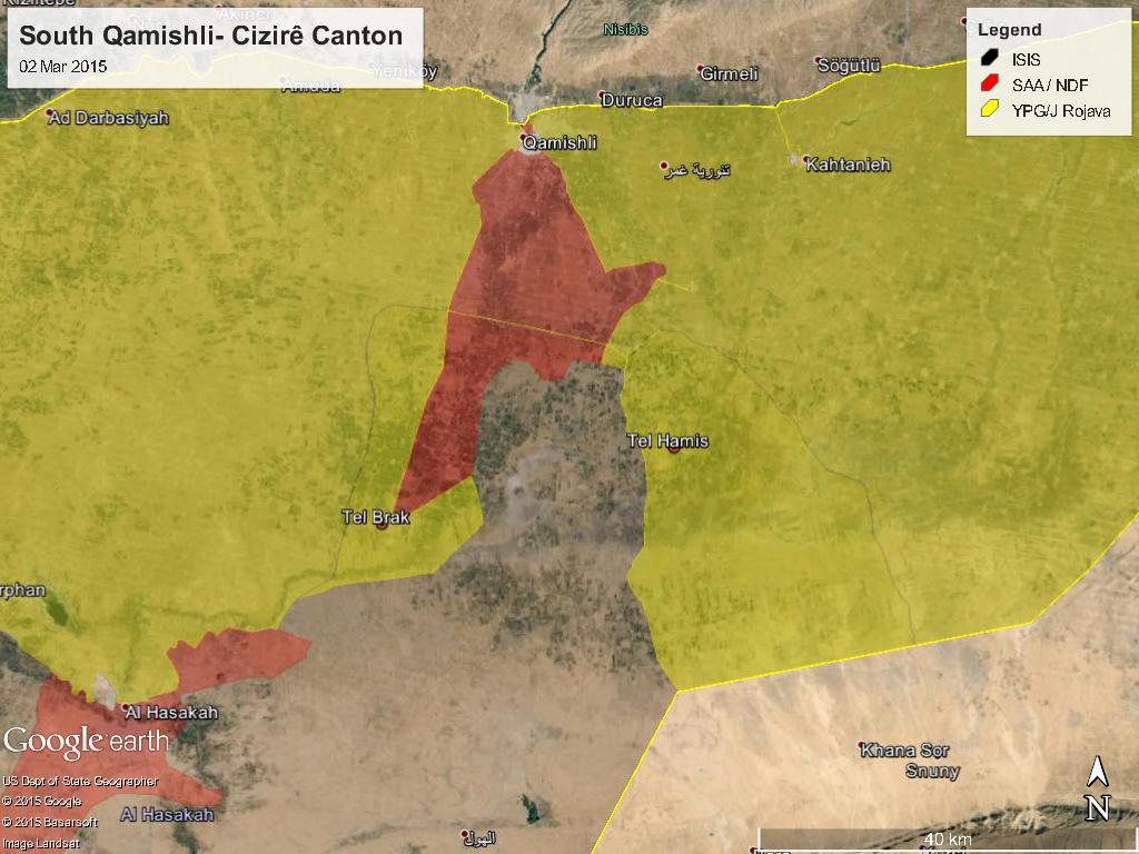
I do not understand which chaneg to the map you suggest. Do you agree the change of Robosiye are not based on reliable sources? I do not think that the situation since 2nd March (day before yesterday) changed much. Is somebody willing to revert the changes I reverted already once? Paolowalter ( talk) 14:04, 4 March 2015 (UTC)
- I only published all data which I have. Hanibal911 ( talk) 17:41, 4 March 2015 (UTC)
Clashes near Khatuniyah - Hasakah
According to pro-government source: https://www.facebook.com/HASAKAHNEWS/posts/70788183599965 and pro-kurdish sources: https://twitter.com/ColdKurd/status/572822285838639105 https://twitter.com/sylezjusz/status/572776705309462528 YPG is clashing with ISIS in the area near the town of Khatuniyah, since there are no villages in between the ones YPG grabbed earlier and Khatuniyah, would a besieged from north icon suffice for the moment?
190.67.236.63 ( talk) 18:28, 3 March 2015 (UTC)
- Also pro opposition source reported about clashes in the village of
Al-Kharitah in Tall Tamer countryside.
Qasion news
Hanibal911 (
talk) 18:43, 3 March 2015 (UTC)
- [22] [23] 2 pro-opp sources saying YPG retreated from Tall Brak and left the regime in charge. This might not be true but it does indicate shared control with the regime. So change Tall Brak to co-held. ChrissCh94 ( talk) 18:50, 3 March 2015 (UTC)
- Step-Agency news is known to be extremely anti-YPG often quoted by pro-IS activists while archicivilians clearly say his source is unconfirmed, furthermore most pro-govt sources have stated government forces have captured villages north of Tal Brak as shown in the map, not that they are inside nor sharing control of the town. Also retreating from the town would not imply that control was shared in the first place either. So we better wait for some pro-govt/more neutral sources to claim this. 179.33.154.71 ( talk) 18:57, 3 March 2015 (UTC)
- I said that this might not be true, but it does indicate that they are both in charge. Many pro-gov sources reported the regime takeover days ago. ChrissCh94 ( talk) 19:04, 3 March 2015 (UTC)
- SAA has shown clear footage of the areas north of Tal Brak it holds while YPG has shown clear footage even in TV channels of its fighters within the town, again, let's wait for more solid proof than a stepnews report. Re: pro-govt sources even hardcore pro-govt Syrian Perspective and more neutral almasdar haven't reported on any presence of SAA within the town, just in the road leading to it with positions that might get close up to a few km and that many might wrongly interpret as shared control of the town itself. 179.33.154.71 ( talk) 19:12, 3 March 2015 (UTC)
Another time someone change all city in north Hasakah to yellow... ( 217.99.142.124 ( talk) 20:33, 3 March 2015 (UTC))
- The vandal who made the change is Roboskiye. Can we banned from editing? I reverted his changes. Maybe also some legitmate change like the one referring to Khatuniyah. Those should be restored. Paolowalter ( talk) 21:06, 3 March 2015 (UTC)
- Please refrain from personal attacks! /info/en/?search=Wikipedia:No_personal_attacks Calling others vandal is unacceptable and would lead you to get banned.
- Secondly, you reverted sourced material from a pro-opposition source, which clearly indicates YPG cleared the whole area between Tal Hamis and Tal Barak, and is just 6 km away from the town of al-Hawl. (Even by logic and common sense reaching Khatuniya means YPG has cleared all the villages behind)
- Thirdly, you even reverted correction of positions 8 villages. This is obvious vandalism by itself. Roboskiye ( talk) 21:21, 3 March 2015 (UTC)
- Roboskiye that pro-opposition source is directly quoting a statement out from YPG ("YPG announced"), so it's no different from PetoLucem for example reporting on something as opposition sourced, would be wiser to wait a few more days to see if SOHR or others can confirm this development. That said, that's nothing to do with Khatuniya since if you look at wikimapia you can clearly see that you don't need to control the villages between Brak and Hamis to get there so I don't see why that edit was reverted too since it was confirmed by pro-govt sources. 179.33.154.71 ( talk) 21:37, 3 March 2015 (UTC)
- There are many other sources which confirm the triangle of Tal Hamis, Tal Barak and Khatuniya is under YPG control. See for example this pro-op: http://aletihadpress.com/news/syria/8830/
- Furthermore, that guy even reverted correction of positions for 8 villages. Roboskiye ( talk) 21:46, 3 March 2015 (UTC)
- Ok that source does confirm YPG did manage to take control of many villages but problem is which? Do we just put everything yellow and if there is any neutral confirmed govt capture of villages -specially in areas directly south of their frontline- we change them? Like user Pyphon said it would have been much better to not fill the map with so many black dots. 179.33.154.71 ( talk) 22:05, 3 March 2015 (UTC)
This is the problem with editors adding tiny villages to the map without prior sources ,they never get mentioned again and get left behind .At some point we will have to change them with out a source which is not how it should work .Isuggest not adding any more villages unless reports state they have changed over control . Pyphon ( talk) 21:56, 3 March 2015 (UTC)
- Between Tal Barak and Tal Hamis, you see like one million black dots (apparently added because of frustration over rapid YPG advances?). Daesh accounts themselves report clashes in villages far south of Tal Barak
https://twitter.com/alansarij3/status/572855093701189632
Roboskiye (
talk) 22:11, 3 March 2015 (UTC)
- No. They were there added because gaining two major cities does not mean that the whole area is under control ypg. If you change all area to yellow - it is mean that we ignore advance SAA and ignore fighting still ongoing. We have source about SAA advance and we will wait for more source, but you change everything using a source that does not saying anything specific. 217.99.142.124 ( talk) 22:27, 3 March 2015 (UTC)
- Between Tal Barak and Tal Hamis, you see like one million black dots (apparently added because of frustration over rapid YPG advances?). Daesh accounts themselves report clashes in villages far south of Tal Barak
https://twitter.com/alansarij3/status/572855093701189632
Roboskiye (
talk) 22:11, 3 March 2015 (UTC)
- Another known vandal revert my changes. Could somebody please revert it again so that I do not break the 1RR rules? Paolowalter ( talk) 07:09, 4 March 2015 (UTC)
Paolowalter,stop being disrespectful to other editors here,you have disrespected multiple editors here,plus you have launched multiple personal attacks on alot of editors here,so you better refrain from such behavior. Alhanuty ( talk) 08:07, 4 March 2015 (UTC)
- Alhanuty but this time he is right. Someone second, third or fourth time change all city in north Hasakah to yellow without any reliable source. 79.187.152.170 ( talk) 08:35, 4 March 2015 (UTC)
Robosiye used multiple sources for his edit,plus the situation on the ground is changing rapidly,and this happened before during ISIS offensive on Kobani,where multiple villages where turned to ISIS controlled. Alhanuty ( talk) 09:02, 4 March 2015 (UTC)
- I wait for his source, because he showed us only one who that does not say anything. [24]. They are fighting in village beetwen Tall Brak and Tall Hamis. This does not mean that all the villages changes to yellow ... When he quote the article, that the fighting in the distric Raqqah it is mean that city Raqqah contested? I do not understand your logic. 83.5.182.215 ( talk) 15:13, 4 March 2015 (UTC)
You all must understand there will not be any sources that mention some tiny villages there so the question is what should we do ? Pyphon ( talk) 16:44, 4 March 2015 (UTC)
- Change only area where we are 100% sure. I mean, we have pro gov source witch name village capture by army, confirmed by neutral source, rebel source and SOHR (last 3 said about 20-30 village without name) and we have pro kurd and pro gov source saying about ypg advance and some village confirmation by other source. As I said before, in this area there not too many reliable source because this area is not to atractive for journalist. Fighting only SAA and YPG and ISIS . ISIS will not talk about their failures, but sometime said about fighting i some villages. 83.5.182.215 ( talk) 18:03, 4 March 2015 (UTC)
Masharah
According to Pro-regime source Mashrah is not contested just besieged in the northeren side. here. Lindi29 ( talk) 19:16, 3 March 2015 (UTC)
- There have endless reports of fighing in the city. The map is qute conservative from the government point of view, but in any case the front line runs through the outskirt of the town. In any case, for villages the difference between contested and besieged is often subtle. Paolowalter ( talk) 20:50, 3 March 2015 (UTC)
- Map is dated on 28 th of February, so a little outdated in this situation, because frontlines are very fluid. There are many cases of doubt, whether certain villages in the area are contested or besieged, but I guess we have to wait until the right info comes from the right source. Raspoetin89 — Preceding undated comment added 08:44, 5 March 2015 (UTC)
South Palmyra
This region together with eastern Qalamun, especially the desert area isn't interesting for neutral sources. Everything here is pro-opposition.
According to Army Usud Shaqijah channels (Authenticity and development front), they captured Al Ulayanija and the areas around after IS withdrew from there. Here are some English pro-opposition sources, from arCivilian, also location explained here. I'm not sure about this guy but he only posts stuff that was published from the original rebel channels on Arabic.
- Some videos posted by ADF groups,
here allegedly after capturing Ulayanija, and
here. I really have no idea but there will be no other sources than this (Ofc. Rebel channels and pro-rebel English channels) ....
DuckZz (
talk) 21:27, 24 February 2015 (UTC)
- DuckZz This is only data from the pro-opposition sources. And we cant use in this issue as a source pro rebels amateur video or data from pro-opposition sources. Also archicivilians and IbnNabih it is biased pro opposition activists. So we need confirmation from more reliable or neutral sources. Hanibal911 ( talk) 21:48, 24 February 2015 (UTC)
- Some videos posted by ADF groups,
here allegedly after capturing Ulayanija, and
here. I really have no idea but there will be no other sources than this (Ofc. Rebel channels and pro-rebel English channels) ....
DuckZz (
talk) 21:27, 24 February 2015 (UTC)
I know, that's why i made a section here to discuss about that. I highly highly doubt there will be any more sources other that from pro-opposition channels. Mainly because these areas are deep inside the desert, nobody cares about that. DuckZz ( talk) 21:56, 24 February 2015 (UTC)
- DuckZz I Get It! Hanibal911 ( talk) 21:59, 24 February 2015 (UTC)
- I wouldn't categorize archicivilians as biased, and his post referred to here tends to confirm that : he just presents this info as a claim by ADF, as well as giving a map localizing the area in question. So we only have a rebel claim, not a confirmation from archicivilians.
- However we could look at that and other info (such as videos) to decide if the rebel claim is founded. We won't be able to do better, since Daesh will never acknowledge any losses, and there aren't even amateur reporters in the desert.
- For info, the ADF was initially armed and trained by the Saudis, and the ADF forces in the southern desert were local rebels of Deir al-Zor before being expelled by Daesh. There is probably no other rebel group as strongly anti-Daesh, other than the kurds and those fighting alongside the kurds. They are probably fighting in the desert since they come from a semi-desert area. I tend to think that their claims are probably true.
- Anyway, whatever you two decide is fine with me. André437 ( talk) 23:54, 26 February 2015 (UTC)
- So in conclusion, I want to say: we cant use this data from pro opposition sources because it would violate the rules of editing. And I am writing this not for experienced editors I writing this for those who have only recently started to edit and still bad know the rules of editing. Hanibal911 ( talk) 10:04, 27 February 2015 (UTC)
- Less simplistically, we can't use claims from one party to support advances of that party against another. Any other information that they provide can be used. As long as, of course, it is sufficient to demonstrate the change we do on the map.
- But of course, simplisticism is the great religion of all times, and editors of this page aren't immune. Such as labeling sources such as archicivilians and desyracuse as pro-rebel (and thus implicitly a rebel source), despite an objective evaluation would consider them non-biased. And some editors considering sources like almasdar (which just echos regime sources without evaluation) as equivalently reliable.
- New editors should read the WP guidelines to better understand these points ... André437 ( talk) 14:20, 27 February 2015 (UTC)
- I disagree with you in situation with Archicivilians! If we can said the source deSyracuse it is just the opposition source but source archicivilians it is very biased source which is openly opposed to the Syrian government and the army and support all rebel groups and thereby distorts information in favor of the rebels. Although often his data do not confirm the reliable sources. Hanibal911 ( talk) 15:10, 27 February 2015 (UTC)
- If you are going to call a source pro-rebel (or pro-regime), it helps to have a basis for the judgement. With almasdar, even a child should be able to recognize that it just echos regime claims. With archicivilians, I suggest that you write down every report you consider false, and the corresponding reports from other media. Then verify that it did not coicide with the situation on the ground during a short period (a few days) before the post appeared.
- Note that if he says "rebels claimed" or "unconfirmed reports that" or "regime sources", you should realize that he is only claiming what the other party said, not confirming that it is true. This is elementary analysis that should be done with each and every report, whatever we consider the source reliable or not.
- It is evident from his presentation that archicivilians has an academic or intellectual background, and is fairly objective. His track record seems at least as good as our map. Of course, it helps to understand what he is saying in his posts.
André437 (
talk) 05:36, 28 February 2015 (UTC)
- Archicivilians its heavily biased toward the Opposition, so we must be carefull with its claims, I Prefeer by far deSyracuse despite he have some errors from time to time. But he is much less Biased than Archicivilians. Archivillians twitter page claims it studies Modern Conflicts, However I only see them spouting Propaganda. Mr.User200 ( talk) 13:34, 5 March 2015 (UTC)
JN commanders
It is only a matter for discussion but associated with Syria. Many source said today that SAA air force hit and kill many high rank commanders reuters, EjmAlrai 18 JN killed Abu Omar al-Kurdi , Abu al-Bara' al-Ansari and Abu Mos'ab al Falastini Samir Hijazi Aka Abu Humam al-Suri Leith Abou Fadel 3 confirmed Al-Nusra leaders killed leader of Nusra's operations in the north and part of their central command 83.26.171.115 ( talk) 21:24, 5 March 2015 (UTC)
- Confirmed but details sketchy. An airstrike in village of Habeet in Idlib killed many of Al Nusra's top leadership. Syria airforce claims the strike. Edward Dark Hanibal911 ( talk) 21:26, 5 March 2015 (UTC)
A video of the destroy building can be seen at ( myawesomedailyfinds )blog . Pyphon ( talk) 16:56, 6 March 2015 (UTC)
Latakia and east Ildib
According regime source saa nad ndf take control in Ildib: Baydr Shamsou and Qarsaayah location here and in latakia Durin village and nearby Mount Duri [25] location here Now we wait for confirmation from other source 83.26.171.115 ( talk) 15:31, 5 March 2015 (UTC)
- And map from
Peto Lucem
83.26.171.115 (
talk) 15:43, 5 March 2015 (UTC)
- Pro opposition sources Documents.Sy Documents.Sy Qasion News and SOHR confirmed that Syrian army gains control over Tel Durin(Mount Durin) in Latakia. Also some pro opposition activists reported that Syrian troops captured two villages in Idlib. here here Also about situation in village Qarsaayah 28 February pro opposition source reported that Regime force entered in Qursaya. here Hanibal911 ( talk) 16:23, 5 March 2015 (UTC)
- Pro opposition source confrirmed that Syrian troops captured villages of Baydr Shamsou and Qarsaayah. Syria News Desk Hanibal911 ( talk) 17:00, 5 March 2015 (UTC)
Durin mount and village taken by SAA AlMasdar. Comment: these areas is clutterd of too many dots: small villages, some of them now of little interest. Can we remove some of them? E.g. Tell Durin after conquer of Durin is of little use. Paolowalter ( talk) 08:15, 6 March 2015 (UTC)
- SAA Captured town Durin.
SOHR
NDF official page
Syria 24
Hanibal911 (
talk) 13:12, 6 March 2015 (UTC)
- Pro opposition source confirmed that the Syrian troops captured town of Durin.
Syria News Desk
Syria News Desk and here TV report of Syrian TV in the town of Durin which was capture of Syrian troops and NDF
here
Hanibal911 (
talk) 20:59, 6 March 2015 (UTC)
- Pro government source said that Syrian troops and NDF have broken Al-Nusra frontlines and entered the town of Salma. here Hanibal911 ( talk) 20:34, 6 March 2015 (UTC)
- Pro opposition source confirmed that the Syrian troops captured town of Durin.
Syria News Desk
Syria News Desk and here TV report of Syrian TV in the town of Durin which was capture of Syrian troops and NDF
here
Hanibal911 (
talk) 20:59, 6 March 2015 (UTC)
| This is an archive of past discussions. Do not edit the contents of this page. If you wish to start a new discussion or revive an old one, please do so on the current talk page. |
| Archive 40 | Archive 41 | Archive 42 | Archive 43 | Archive 44 | Archive 45 | → | Archive 50 |
A common battle scenario - for reflection by editors
This scenario reflects what often happens in real battles between 2 well organized armies.
Army x sends several battalions into territory controlled by army y. The weather is not clear, and army y is caught by surprise, and doesn't notice the incursion right away. Army x takes a few villages.
When army y notices the incursion, they send reinforcements to the area, and in the counter attack army x suffers heavy losses and is forced outside most of the villages they have entered.
Army x sends reinforcements, and manages to reenter most of the villages they entered before, and there are heavy casualties on both sides. Additional reinforcements from army y arrive, and again army x is expelled, this time with much heavier casualties. The battle persists in one or two of the attacked villages. Army y regains total control of most of the battlefields, with dozens of fallen enemy soldiers.
Meanwhile, some forces of army x succeeded passing through enemy lines to attain an area under their control, but besieged by army y.
News agency a, which relies on pro-army x media (they never listen to "terrorists"), reports that army x has made tremendous advances, describing the area controlled before army y counter-attacked, adding a little extra territory for good measure.
Map drawer b, relying on news agency a, quickly draws a new map, adding a little more for good measure. He always trusts news agency a, since he never listens to "terrorists" either.
News agency c, who tries to be impartial even though he doesn't really like army x, reports the situation after the first counter-attack by army y, which retook most of the villages.
News agency d, waits a while, and reports the situation during the second wave of attacks by army x. He doesn't trust "amateur videos", so he ignores the videos produced on the ground by various observers. He reports clashes in most villages, with army x in control of some.
Some observers on the ground later report that army y has regained control of almost all the villages, with clashes ongoing in the rest.
So of the various reporters, who is right ?
We could say they all are, although some exaggerate the situation according to their bias.
- 1) initially, army x gains a lot of territory, according to a and b
- 2) army y counter-attacks to expels them from much of the territory, according to c
- 3) army x sends reinforcements to retake much lost, according to d
- 4) at the end of the day, army y prevails in almost all the territory, with heavy losses for army x, according to observers on the ground.
This is a typical situation in a real war.
So what is my point ?
This isn't a video game. In real war, fortunes can change quickly, and what is true at one moment can be far from true a few hours later.
Since we are supposed to be indicating the situation for readers who will likely be viewing our map a few hours or days later, we don't have to try to give minute-by-minute results. Our sources aren't that up to date. They often depend on info days or even a week out of date. So we should wait until a situation stabilizes before posting changes.
André437 (
talk) 12:15, 19 February 2015 (UTC)
- Stop the Propaganda Andre, Wp its not a Soapbox.
http://en.wikipedia.org/wiki/Wikipedia:What_Wikipedia_is_not#Wikipedia_is_not_a_soapbox_or_means_of_promotion
200.48.214.19 ( talk) 12:55, 19 February 2015 (UTC)
- Stop the Propaganda Andre, Wp its not a Soapbox.
- André437 This should be a math exercise in High School! Too many variables lol. ChrissCh94 ( talk) 13:58, 19 February 2015 (UTC)
- @ 200.48.214.19 Propaganda ? Obviously you didn't understand, as well as not knowing where the soapbox rule should apply. I suggest you reread my post a few times, and maybe consult someone who knows what war is.
- @ ChrissCh94 Math gets a lot more complicated after high school. Seriously, all editors should understand the points raised in my post.
- @ Ariskar We should be looking at the reliability of the information. The track record of the source is only part of the puzzle.
- @ everyone : In a rapidly changing situation open to quick reversals, it is not useful to update the map with uncertain info of the status of a day ago or 6 hours ago, when it likely would have changed. Sometimes the adage patience is a virtue applies in real life.
- If you were to apply my post (with variations) to the recent situation north of Aleppo city, you would realize that the regime made minimal gains if not losses (to date) for very high casualties, and even more fighters captured. All those rebel videos of fields strewn with regime fighter bodies means that not only the regime lost many in the battlefield, but the rebels ended up controlling the battlefield. It was a disaster for regime forces.
- You should all think about this the next time an unexpected advance occurs. If it were the rebels advancing, most editors here would show a lot more caution. As it should be for both sides. André437 ( talk) 18:22, 19 February 2015 (UTC)
- Jokes aside André437, you do have a point here. But it is us who were caught off guard. Usually SAA operations in Aleppo have been steady forward. There was no back and forth. They usually do not lose ground they gain. Well that was the past. This battle was different for many reasons. Till now it seems it is a Pyhrrhic victory for the SAA but who knows tomorrow what might happen because whoever triumphs in this battle, will probably have his fate sealed in Aleppo. I have to congratulate all editors who stayed up to date with the battle. The map edits were made in accordance with the rules and in fact it's something to be proud of. I don't see the point of having an out of date map. ChrissCh94 ( talk) 18:44, 19 February 2015 (UTC)
- Andre you are delutional...... 200.48.214.19 ( talk) 18:49, 19 February 2015 (UTC)
- @ ChrissCh94 Indeed, as well as the rebels, the editors here were caught off guard. But it is definitely not the first time that an advance by one group in an area has been quickly reversed. Another more dramatic example is when Daesh took Raqqa. For 3 days near the beginning of january, the rebels (most FSA units that had nominally joined Nusra for protection against Daesh predation) had expelled Daesh from the city, although they remained besieged since Daesh blocked the bridges and other access to the city. During those 3 days, Daesh brought in large numbers of reinforcements, and subsequently captured the city.
- In this case, our map was never up to date, since the status on the ground changed before the reports we depended on were even published. And of course, many editors rejected out of hand accurate reports from SOHR and others that showed rebels retaking lost villages. Before the news of the second wave of attacks by the regime, the rebels and observers were already publishing videos of battlefields strewn with bodies of regime fighters - after the second wave was repelled.
- Even now, our map shows Hardatnin as contested, not accurate unless you consider the remaining regime fighters holed up in 2 buildings surrounded by rebel forces demanding their surrender as a significant regime presence. (Videos show rebels surrounding regime fighters shouting back and forth, with no gunfire.)
- As well, a well disciplined rebel unit advanced to take the hills just south of Handarat village, an important regime loss that could lead to the rebels retaking all the area north of Aleppo city. For that, time will tell. But losing at least 200..300 fighters (dead + captured) is certainly not going to help the regime.
- I might add that our goal should not be that of a news agency trying to show the latest "scoop". If someone wants the latest battle news, they are not going to look at our map. They are going to follow media sources like EJM and others, who often get it wrong. We should try to accurately reflect the situation which has been stable for the last few days. As well, we should be creating a history of the evolution of the civil war, by updating the tables as we make changes to the map. Something we have (collectively) been neglecting for the last year or more. Remember the WP guideline : Wikipedia is not a news agency.
- @ 200.48.214.19 If recognizing the reality on the ground (after waiting for the information to come in) is "delutional" (delusional), so be it.
- ... André437 ( talk) 08:02, 20 February 2015 (UTC)
- What you stated André437 came from rebel sources purely. Even SOHR said regime casualties are in the 100-120 as well as 30 POWs (rebels suffered similar losses, basic SOHR stuff). Regime sources are still insisting that the battles are AROUND Hardatin and Pashqwi. TheDailyStar [1] recently published an article affirming regime control albeit besieged in Hardatin. Depsite those indicators, we still used SOHR as a credible and privileged source and marked Hardatin as contested despite it being a pro-opp source. So in fact we are still marking an area as contested when SOHR mentions rebel advances in it, while when other pro-opp sources mention this we don't change anything. However we cannot use SOHR they way we used to do in the past because its credibility has been damaged quite alot. So we can't mark an area as rebel-held just because SOHR said so. But we will mark it as contested to keep using SOHR as a "superior" and more credible source than other pro-opp ones. However if SOHR continues its descent, I'm afraid it will be used the same way other pro-opp sources are: just to mark regime gains. ChrissCh94 ( talk) 09:42, 20 February 2015 (UTC)
- @ ChrissCh94 You seem to be missing a few points.
- 1) For the record, I advocated showing the rebel villages as contested when regime forces arrived, only to face a barrage of criticism, other editors insisting that they were regime controlled, mostly based on a pro-regime map, characterized as "reliable". That is like the canard that almasdar is "reliable", despite only uncritically echoing regime reports, according to their own claims.
- 2) The regime never established control over these villages. Presence does not equal control. This is evidenced by numerous videos (by various sources) showing battlefields strewn with regime bodies. Thus it was entirely inappropriate to ever have shown regime control over these rebel-held villages, even temporarily. Yet remarks on this page indicated that they were shown under regime control. If so, that was an error. (I didn't verify it.)
- One commentator on this page had the disingenuous remark that the videos were really showing rebel bodies, despite quite a few close-ups showing regime insignia and/or id, and some even showing iranian id. As well, it was obvious that the rebels were in control of these battlefields.
- 3) When the few remaining regime forces in Hardatnin were partially or fully besieged, they were in no way a threat to rebel control. So the village was no longer contested.
- 4) As far as SOHR statements of casualties and prisoners, is it well known that SOHR is conservative in its' estimates (requiring strict confirmation to support its' figures), and thus tends to be somewhat late in reporting figures. You give figures of 100-120 + 30 = 130-150. The few videos and photos I've seen show at least 100 bodies in battlefields + at least60-70 prisoners. Thus at least 160. Since I can't possibly have seen all, and also considering the dead and wounded that remained in regime possession, 200 would be a reasonable estimate of minimum regime losses. I said 200..300, but some (pro-rebel) sources claimed much higher numbers.
- 5) The article you cite says (in one sentence) that the regime was "besieged" (in 2 of the 3 villages, not 1), but what do they mean by "besieged" ? We used besieged to indicate that the inside party has real control in the area. Not for temporary incursions where the forces are surrounded with no control. (And no heavy weapons, BTW.) As well, we knew it was an unstable rapidly changing situation. How out of date was the article when it was published ?
- 6) In sum, the 3 villages in question should have been changed to contested and never regime held, and reverted to rebel held as it became apparent that the regime offensive failed. Following WP guidelines, we should use a conservative approach in our changes to the map. That is not what is happening.
- You shouldn't be surprised that this is perceived as a pro-regime bias, also evident in the comments of a number of other contributors.
André437 (
talk) 00:52, 23 February 2015 (UTC)
- Let me answer you point by point. André437
- 1) We used SOHR and TheDailyStar to prove that Hardatin and Pashqoi were regime-held while Rityan was contested. Rebel sources explaining their counter-attack blamed the regime takeover on treason. So yes the regime DID FULLY TAKE OVER those 2 towns.
- 2) They established a presence there that's why the frontline was moved to an area near Nubl and Zahraa and not inside those villages (at first)
- 3) Regime forces were besieged in Hardatin yet they broke the siege and returned to Pashqoi, they broke through hostile lines thus they are considered a threat.
- 4) SOHR always overestimates regime casulaties. Prisoners you saw were partly those detained in Myasat Hill while not all the dead are filmed once. Basic propaganda used by both rebels and regime forces. SOHR even stated 50 rebels are captured by the SAA yet the latter did not film them, does this mean the capture did not take place? I'm surprised you still take video/photo evidence seriously in this conflict.
- 5) In fact they (SAA troops) were besieged in Hardatin while retaining control over most of it. That's how they managed to retreat without POWs. Unlike Rityan where I was the first to say that it was contested and that's where they were practically besieged in a building. 2 very diff scenarios to compare. Hardatin was besieged yet under SAA control until they safely withdrew .
- 6) In sum what happened is that the SAA took over Pashqoi (the main obj of the campaign) yet found no resistance and took over Hardatin and reached Rityan. However the rebel counter attack was swift thanks to Jabhat al Nusra and the influx of weapons and manpower from the countryside and from Turkey. They outflanked the SAA in Rityan (which was already contested) and managed to besiege a group of 30 fighters while the rest broke the siege and went to Hardatin/Zahraa (proves my point that besieged troops are perfectly capable of acting cf. Tabaqa airbase.). Then the rebels captured most of al Mallah and besieged Hardatin. The SAA did not have time to fix its positions in Hardatin, thus they retreated with their heavy weaponry to Pashqoi. It can be summed as: Rebels takeover most of Al Mallah farms thus preventing a siege while regime forces capture Pashqoi and get closer to Nubb-Zahraa. Pyrrhic and partial victory for both sides: regime offensive partially (if not mostly) failed with heavy casulaties for only 1 village while rebels, as defendants, also suffered nearly as much casualties and POWs despite their gain. ChrissCh94 ( talk) 09:54, 23 February 2015 (UTC)
Turkish ground forces intervention
We now have confirmed that Turkish ground forces crossed into Syria through Kobane border crossing and are on the way to Suleiman Shah tomb. According to Turkish source this involved at least 40 armored vehicles (photos showing also several tanks) and helicopter air support.
http://www.sanliurfa.com/mursitpinar-kapisinda-suleyman-sah-hareketliligi/1671429589/
This is unlikely last rotation of TSK in the tomb last year, this is combat intervention. Should we put up a tomb on a map and marked it as under control of Turkish troops / contested currently? EllsworthSK ( talk) 00:02, 22 February 2015 (UTC)
go ahead,i believe so,put turkey as Purplish red,to distinguish from Regime forces. Alhanuty ( talk) 00:50, 22 February 2015 (UTC)
But the tomb of Sulayman Shah is turkish territory and not syrian, so imho is a nonsense to put a new icon on the map, we should edit the background map instead (even if it would be a tiny dot) -- 8fra0 ( talk) 09:10, 22 February 2015 (UTC)
- Alhanuty EllsworthSK Turkish army just send 700 soldiers and 39 tanks for safe transport the of Tomb Salesman Shah from the ISIS territory on the Turkish territory where will be a new location the of Tomb Salesman Shah. Elijah J. Magnier Elijah J. Magnier Turkish forces entered into Syria overnight to rescue about 40 soldiers who had been surrounded for months by Islamic State militants while guarding the tomb of a revered Turkish figure. The military said no clashes took place during the operation although one soldier had been killed in an accident.
The 38 soldiers who had been guarding the tomb of Suleyman Shah, grandfather of the founder of the Ottoman Empire, were brought safely home. The tomb, which is on a site within Syria that Ankara considers sovereign territory, was relocated. Reuters And here on photos the Turkish soldiers fixing a flag in the new location of tomb Suleiman Shah on the Turkish-Syrian borders. Elijah J. Magnier So that it just the 700 Turkish sokdiers from Special Forces were used in the removing of Tomb Salesman Shah from ISIS territory. Elijah J. Magnier and here new location of the Tomb Suleiman Shah on the Turkish territory. Elijah J. Magnier Panoramio So that we dont need new mark on map. Hanibal911 ( talk) 11:20, 22 February 2015 (UTC)
- Another source said that 40 Turkish tanks and armoured vehicles entered to the areas which controlled of Kurds heading towards tomb Suleyman Shah in order to lift siege of ISIS forces in this area
here which was besieged of Kurds.
Fer Gunay
Hanibal911 (
talk) 11:59, 22 February 2015 (UTC)
- Khaled Khoja the president of the Syrian Coalition said that the tomb Sleiman Shah inside Syria has been "safely" relocated to Turkey. Syrian National Coalition & FSA were informed of this plan. Khaled Khoja Hanibal911 ( talk) 12:35, 22 February 2015 (UTC)
- Another source said that 40 Turkish tanks and armoured vehicles entered to the areas which controlled of Kurds heading towards tomb Suleyman Shah in order to lift siege of ISIS forces in this area
here which was besieged of Kurds.
Fer Gunay
Hanibal911 (
talk) 11:59, 22 February 2015 (UTC)
- The location of Suleyman Shah's tomb is a sovereign territory of Turkey according to France-Turkey 1921 Agreement. Syria obeyed and still obeys that agreement, and since 1921 every sovereignty symbols (Flags, Soldiers, etc.) of Turkey appeared on that territory. When Syria-Turkey border is drawn in 1921, the border separated some villages into two. The naming of most of these villages currently are like that: the part of the villages in Turkey's side is named in Turkish. The parts of the villages in Syria's side is named as the Arabic of the Turkish name or the original Turkish name was protected but with Arabic spelling. This is valid for the new place of the tomb as well: Turkish Eşme (Esme) is in Turkey's side, Syrian Ashma is in Syrian side. Turkey transferred sovereignity of 10000 m2=0.01 km2 territory together with the tomb in Qaraqozak inside another place within Syria (i.e., Syrian Ashma; 200 m from Turkey-Syria border). The Turkish flag is raised in Ashma (200 m from the Turkey-Syria border). The corpses of Suleyman Shah is temporaly in Turkey. When the grave and tomb in Ashma is finished, the corpse of Suleyman Shah will be transferred to Ashma. Hence, sovereign territory was exclave of Turkey, now it is juxtapositioned to Turkey.
- The current change of Suleyman Shah's tomb is not the first change of the sovereign territory within Syria. Due to several reasons (new dams affecting the tomb etc.), sovereign territory of Turkey within Syria was changed earlier many times: 1. From original place to the Caber Castle. 2. From Caber Castle to Qaraqozak village. 3. From Qaraqozak village to Ashma. In all of these changes, sovereignity of Turkey was protected. i.e. Only Turkish flag, Turkish soldiers can be located in that 0.01 km2 territory.
- In http://en.wikipedia.org/wiki/Template:Syrian_Civil_War_detailed_map#Ashma , there must be a symbol of tomb must be put. And, Ashma must be indicated as Turkey's territory. 212.174.38.3 ( talk) 10:18, 23 February 2015 (UTC)
- Hanibal911 says: "...The tomb, which is on a site within Syria that Ankara considers sovereign territory,..."
- Ankara Treaty 1921:
http://www.hri.org/docs/FT1921/Franco-Turkish_Pact_1921.pdf
- Article 9: The tomb of Suleiman Shah, the grandfather of Sultan Osman, founder of the Ottoman dynasty (the tomb known under the name of Turk Mezari), situated at Jaber Kalesi shall remain, with its appurtenances, the property of Turkey, who may appoint guardians for it and may hoist the Turkish flag there.
- Hanibal911, since 1921 no Syrians entered the tomb's area without the allowance of Turkey, and cannot enter hereafter as well. You say "...Ankara considers...". It is not only "...Ankara considers..." but also "...accepted and respected by Damascus and the others...". After Syria lost the territory (all the areas and territories around the tomb) to ISIL, ISIL respected the tomb's area as well. Turkish government said any attack on the tomb is a casus belli. 212.174.38.3 ( talk) 10:43, 23 February 2015 (UTC)
Derik and Rumeilan bases
What is the source for SAA having any sort of base there? Derik never had any actual military unit attached there, nor does any army base appears on sattelite images and Rumeilan has been overrun by YPG in 2012 as you can see here Robert Fisk report from Rumeilan where he sees YPG guarding it or here. There is also another source here [2]. EllsworthSK ( talk) 23:14, 22 February 2015 (UTC)
- EllsworthSK Last year was the source who confirmed that the Rumailan oil field under jointly control by Kurds and army and I noted oil field under control by Kurds and marked the Hajanah battallion near the Oil field under control by army. Here pro opposition source reported that the Rumeilan oil fields in Hasakah province still under jointly control of the Kurdish forces of the Popular Protection Units (YPG) and pro-regime forces in the area. ARA News Also I remember that other editor add to map Armoured Army Base near the town of Al Malikiyah(Derik) because reliable source showed on map that army still present in this area near this town. Hanibal911 ( talk) 09:30, 23 February 2015 (UTC)~
- The ARAnews link only throws a biased accusation of being pro-regime on YPG. Also the small base in Derik was abandoned more than two years ago by its soldiers who had put off their military dresses and left beyond their military vehicles. YPG showed back then a video inside the base. Roboskiye ( talk) 09:47, 23 February 2015 (UTC)
- I'm reading the link and all I see is this Rumeilan oil fields in Hasakah province still submit to the control of the Kurdish forces of the Popular Protection Units (YPG) an pro-regime forces in the area. First of all, source baisly accuses YPG of being pro-regime, second source never mentions anywhere regime (SAA or NDF) presence in the oil fields. Perhaps someone misread the text and mistook and with an. In Derik what you claim is operational base has been discarded by Syrian military well prior to civil war and now its used as main base for YPG
as said here. There is no regime presence in either Rumeilan or Derik. The regime triangle south of Qamishlo is far from being correct, but we'll leave that for later. Supplying sources for that is next to impossible.
EllsworthSK (
talk) 09:57, 23 February 2015 (UTC)
- EllsworthSK Roboskiye I'm not add to map military base near the town Al Malikiyah(Derik) so I dont say that it was justified action or that this base was really under control of army. So that in issue about military base near Derik I will not object you. But about the Rumeilan oil fields pro opposition source ARA News clearly said that they still under jointly control. And Roboskiye ARA newe it is a biased antigovernment source and according to the rules of editing we can use him data for display a success of army. So according to data in our discussion we can note a military base near Deril under control by YPG but base near oil field should be left under the control of the army because this confirm source. Hanibal911 ( talk) 10:35, 23 February 2015 (UTC)
- I'm reading the link and all I see is this Rumeilan oil fields in Hasakah province still submit to the control of the Kurdish forces of the Popular Protection Units (YPG) an pro-regime forces in the area. First of all, source baisly accuses YPG of being pro-regime, second source never mentions anywhere regime (SAA or NDF) presence in the oil fields. Perhaps someone misread the text and mistook and with an. In Derik what you claim is operational base has been discarded by Syrian military well prior to civil war and now its used as main base for YPG
as said here. There is no regime presence in either Rumeilan or Derik. The regime triangle south of Qamishlo is far from being correct, but we'll leave that for later. Supplying sources for that is next to impossible.
EllsworthSK (
talk) 09:57, 23 February 2015 (UTC)
- Hannibal, there is no such claim in that article as But about the Rumeilan oil fields pro opposition source ARA News clearly said that they still under jointly control. You are mistaking and with an. That is all. No such thing is written there, quite on contrary. EllsworthSK ( talk) 16:21, 23 February 2015 (UTC)
- I have no problem with ARAnews. But it does NOT say pro-regime forces are there. You have misread the text. Read it once again. It says ONLY YPG is there in the oilfield. Roboskiye ( talk) 10:43, 23 February 2015 (UTC)
I agree on removing both, but if not possible at least the base on Derik, as the Syrian Regime doesn't have a base there for sure. — Preceding unsigned comment added by 177.16.154.30 ( talk) 10:40, 23 February 2015 (UTC)
- Roboskiye Source clear said that Rumeilan oil fields in Hasakah province still submit to the control of the Kurdish forces of the Popular Protection Units (YPG) and pro-regime forces in the area. So that source clearly indicated on the fact that Kurds and pro-regime forces in this area still controlled the Rumailan oil fields but not only Kurdish forces. So let's just noted military base near Darik as under control YPG. Hanibal911 ( talk) 12:16, 23 February 2015 (UTC)
- Here is the original Arabic article of Aranews as provided by Zaradasht Khalil as of July 16, 2014:
http://aranews.org/2014/07/60-%D9%85%D9%86-%D8%A7%D9%84%D9%86%D9%81%D8%B7-%D8%A7%D9%84%D8%B3%D9%88%D8%B1%D9%8A-%D8%AA%D8%AD%D8%AA-%D8%B3%D9%8A%D8%B7%D8%B1%D8%A9-%D8%AA%D9%86%D8%B8%D9%8A%D9%85-%D8%A7%D9%84%D8%AF%D9%88%D9%84/ There is no mention of any regime presence in Rumeilan oildfields. Regards.
Roboskiye (
talk) 12:53, 23 February 2015 (UTC)
- Roboskiye Ok I remove the Hajanah Battalion from map. Or we should be noted this military base under the control of the Kurds? Hanibal911 ( talk) 13:06, 23 February 2015 (UTC)
- Here is the original Arabic article of Aranews as provided by Zaradasht Khalil as of July 16, 2014:
http://aranews.org/2014/07/60-%D9%85%D9%86-%D8%A7%D9%84%D9%86%D9%81%D8%B7-%D8%A7%D9%84%D8%B3%D9%88%D8%B1%D9%8A-%D8%AA%D8%AD%D8%AA-%D8%B3%D9%8A%D8%B7%D8%B1%D8%A9-%D8%AA%D9%86%D8%B8%D9%8A%D9%85-%D8%A7%D9%84%D8%AF%D9%88%D9%84/ There is no mention of any regime presence in Rumeilan oildfields. Regards.
Roboskiye (
talk) 12:53, 23 February 2015 (UTC)
- Hanibal could you also move the Rimelan oilfield battallion a bit to the left? As it's now it can be hard to notice there's an oilfield being guarded by the base since they both overlap quite a bit. Thanks.
186.116.23.131 ( talk) 12:36, 23 February 2015 (UTC)
Hardatin
From SOHR fighting is still ongoing around Hardatin. Should we mark it with a red half ring? Paolowalter ( talk) 20:03, 22 February 2015 (UTC)
- Perhaps you are right! Hanibal911 ( talk) 20:52, 22 February 2015 (UTC)
SAA frontlines are still around Bashkuy and Dweir-AlZeitun..they`re not even close to Hrdatnin.the only change is that SAA recaptured northern part of Al-Malah farms yesterday while Malah village,southern Mallah and Arab-Sulum(between Handarat village and Arad Malah)totally under militants control..that`s the most recent update of frontlines.Rida Albasha (AlMayadeen reporter) is my friend,He informs me everything happens on the field neutrally every few hours via chat.If anyone wants confirmation,his news publishes in ElijahMagnier and many other credible pro/opp sources in twitter some hours later! — Preceding unsigned comment added by Xerxes92005 ( talk • contribs) 08:05, 23 February 2015 (UTC)
- @ Xerxes92005 We do need confirmation from published sources, but thanks for letting us know what to look for. If you can find published references, could you post them with your comments ? Thanks . André437 ( talk) 05:08, 24 February 2015 (UTC)
villages of Tehama ,Takleb ... #YPG advance
https://twitter.com/ColdKurd/status/569532093266587648 — Preceding unsigned comment added by Creepz55 ( talk • contribs) 16:36, 22 February 2015 (UTC)
Pro-kurdish source can't be used to show YPG advances. DuckZz ( talk) 16:38, 22 February 2015 (UTC)
- Agreed with DuckZz need data from neutral source. Hanibal911 ( talk) 16:53, 22 February 2015 (UTC)
Here is the location of the three claimed villages:
https://twitter.com/yunus4akca7/status/569568104411480064
According to local pro-govr source clashes are happening in the area between YPG and its al-Karama militia against Islamic State:
Enough for at least putting the villages in the map as contested?
186.116.23.131 ( talk) 18:49, 22 February 2015 (UTC)
- I think that it's enough, also reliable source https://twitter.com/EjmAlrai/status/569490519677661184 is confirming the clashes there -- 8fra0 ( talk) 19:12, 22 February 2015 (UTC)
http://www.reuters.com/article/2015/02/22/us-mideast-crisis-syria-iraq-idUSKBN0LQ0RG20150222?feedType=RSS&feedName=worldNews. Alhanuty ( talk) 21:14, 22 February 2015 (UTC)
- Here more data from pro opposition source about the Kurdish advances in Hasakah province near Iraqi border.
ARA News
Hanibal911 (
talk) 12:53, 23 February 2015 (UTC)
- Here reliable source reported that Kurdish forces and Syrian troops attacking ISIS between Jaz'a and Tel Hamid where over 25 villages were retaken from ISIS. And their aim is to reach Tel Hamid. Elijah J. Magnier Hanibal911 ( talk) 13:12, 23 February 2015 (UTC)
- Here more data from pro opposition source about the Kurdish advances in Hasakah province near Iraqi border.
ARA News
Hanibal911 (
talk) 12:53, 23 February 2015 (UTC)
- Note pro-govt almasdar also reported both forces are attacking ISIS but specified that this is not a joint operation, with SAA attacking the northern perimeter from their current positions northwest while the attacks between Jaz'a and Tal Hamis (as shown currently in the map) were carried out by kurdish forces: http://www.almasdarnews.com/article/isis-stronghold-tal-hamees-besieged-sides/ 186.116.23.131 ( talk) 14:06, 23 February 2015 (UTC)
- ANHA reports YPG liberated two more villages southwest of Jaz'ah. The villages are called Lesser and greater Qurtuba (Cordoba). Moreover, according to the source, clashes are continued near Ghasan village, some 24 km south of Ta Hamis.
http://ar.hawarnewsagency.com/%D8%AA%D8%AD%D8%B1%D9%8A%D8%B1-%D9%82%D8%B1%D9%8A%D8%AA%D9%8A%D9%86-%D9%88%D9%85%D9%82%D8%AA%D9%84-%D8%A3%D9%85%D9%8A%D8%B1-%D8%AA%D9%88%D9%86%D8%B3%D9%8A-%D8%AC%D8%AB%D8%AA%D9%87-%D8%A8%D9%8A%D8%AF/
Roboskiye (
talk) 16:25, 23 February 2015 (UTC)
- Also pro-ISIS sources confirm further YPG/Pesh advance in the area: https://twitter.com/mrasilh/status/569901576137121792
- ANHA reports YPG liberated two more villages southwest of Jaz'ah. The villages are called Lesser and greater Qurtuba (Cordoba). Moreover, according to the source, clashes are continued near Ghasan village, some 24 km south of Ta Hamis.
http://ar.hawarnewsagency.com/%D8%AA%D8%AD%D8%B1%D9%8A%D8%B1-%D9%82%D8%B1%D9%8A%D8%AA%D9%8A%D9%86-%D9%88%D9%85%D9%82%D8%AA%D9%84-%D8%A3%D9%85%D9%8A%D8%B1-%D8%AA%D9%88%D9%86%D8%B3%D9%8A-%D8%AC%D8%AB%D8%AA%D9%87-%D8%A8%D9%8A%D8%AF/
Roboskiye (
talk) 16:25, 23 February 2015 (UTC)
Some of the villages captured today by YPG in southeast and east of Tal Hamis are: http://ar.hawarnewsagency.com/%D8%AA%D8%AD%D8%B1%D9%8A%D8%B1-9-%D9%82%D8%B1%D9%89-%D9%81%D9%8A-%D8%B1%D9%8A%D9%81-%D9%82%D8%A7%D9%85%D8%B4%D9%84%D9%88/ Zahra: http://wikimapia.org/#lang=en&lat=36.583503&lon=41.434121&z=16&m=b Zahran: http://wikimapia.org/#lang=en&lat=36.641255&lon=41.579089&z=16&m=b Gassan: http://wikimapia.org/#lang=en&lat=36.549100&lon=41.420412&z=19&m=b Homs: http://wikimapia.org/#lang=en&lat=36.596341&lon=41.473694&z=18&m=b Hulwa: http://wikimapia.org/#lang=en&lat=36.803746&lon=41.588815&z=18&m=b Tal Tahin: http://wikimapia.org/#lang=en&lat=36.812514&lon=41.600064&z=17&m=b Roboskiye ( talk) 10:26, 24 February 2015 (UTC)
ISIS advances against Kurds in Tall Tamer countryside
Pro opposition source reported that ISIS captured village of Tall Shamiram after clashes against YPG. Qasion news and that ISIS kill civilians and burn the Ashuryan Church in the town of Tall Tamer. Qasion news SOHR also reported that ISIS captured village of Ghabshah. SOHR Hanibal911 ( talk) 13:28, 23 February 2015 (UTC)
- According to ANHA, YPG is fighting in and around Ghibish and Tal Shamiran villages. The villages are not fully under ISIS jihadi's control and should be changed to contested.
http://ar.hawarnewsagency.com/%D8%AA%D8%AD%D8%B1%D8%B1-%D8%A7%D9%84%D8%B9%D8%B4%D8%B1%D8%A7%D8%AA-%D9%85%D9%86-%D8%A3%D8%A8%D9%86%D8%A7%D8%A1-%D9%82%D8%B1%D9%8A%D8%A9-%D8%BA%D9%8A%D8%A8%D8%B4/
Roboskiye (
talk) 19:14, 23 February 2015 (UTC)
-
Roboskiye According to the rules of editing we cant use pro-Kurdish source in this issue and we cant marked villages of Ghibish and Tal Shamiran as contested we need confirmation from neutral source.
Hanibal911 (
talk) 19:58, 23 February 2015 (UTC)
- Reliable source reported that YPG now fighting against ISIS in the village of Khabur. Elijah J. Magnier and Syrian air force is also targeting ISIS convoy which heading toward the same area. Elijah J. Magnier Hanibal911 ( talk) 20:13, 23 February 2015 (UTC)
-
Roboskiye According to the rules of editing we cant use pro-Kurdish source in this issue and we cant marked villages of Ghibish and Tal Shamiran as contested we need confirmation from neutral source.
Hanibal911 (
talk) 19:58, 23 February 2015 (UTC)
- Pro-regime source claims NDF controls village of Khaza’at north of Tal Hamees. It also states YPG fighting in villages of Taweel, Al-Zaaqat, and Amnat.
It claims regime forces come from north to liberate Tal Hamees, while ypg coming from south to also liberate Tal Hamees. http://www.almasdarnews.com/article/isis-stronghold-tal-hamees-besieged-sides/ — Preceding unsigned comment added by 169.231.150.148 ( talk) 22:44, 23 February 2015 (UTC)
Also many many reports now online of assyrian militias in the area mobilizing.. and beheaders attacking assyrian civilians,women & children. Not sure if assyrians are working with kurds or damascus government?
Official statement of Syriac Military Council https://twitter.com/kovandire/status/569955779652014080 citing at least two other villages captured by IS today( Tel Hourmiz and Tel Tawil) that should be changed to black on map , but the same source says there are many others ...I think a large number of the Khabour River villages are now in IS hands...and about Tel Tamer itself: is it contested? Many reports of fighting inside the town, though not from a major source... Fab8405 ( talk) 23:52, 23 February 2015 (UTC)
I don't know if this is a reliable source, sure is not pro-IS...this map pretend to show the 10 villages on the Khabour River captured today by IS...if it's accurate, the villages should be Tal Tawil, Tal Shamiran( already edited), Tal Talla, Abu Tina, Tel Quran, Qabr Shamiya, Kharitha, Tal Makhatha, Tal Taal, Tal Hurmiz...here is the map, decide you what use to do of it https://twitter.com/rConflictNews/status/569988674064154624 Fab8405 ( talk) 00:33, 24 February 2015 (UTC)
-
Fab8405 This map
here from the reliable source.
le_carabinier
Hanibal911 (
talk) 10:16, 24 February 2015 (UTC)
- Pro opposition source reported that Syrin troops to support YPG sent three tanks from Qamishli to Tel Tamer.
Hasakah News
Hanibal911 (
talk) 10:21, 24 February 2015 (UTC)
- Pro Kurdish source reported that Syriac Military Council(MFS), Peoples Protection Units(YPG) and the Khabour Guards recaptured village of Agbish to west of Tel Tamer.
Syrian International News Agency
Hanibal911 (
talk) 11:40, 24 February 2015 (UTC)
- Here another source confirmed that YPG, Syriac Military Council(MFS) and Assyrian fighters recaptured village Agbish to west of Tall Tame. jack Shahine Hanibal911 ( talk) 18:19, 24 February 2015 (UTC)
- Pro Kurdish source reported that Syriac Military Council(MFS), Peoples Protection Units(YPG) and the Khabour Guards recaptured village of Agbish to west of Tel Tamer.
Syrian International News Agency
Hanibal911 (
talk) 11:40, 24 February 2015 (UTC)
- Pro opposition source reported that Syrin troops to support YPG sent three tanks from Qamishli to Tel Tamer.
Hasakah News
Hanibal911 (
talk) 10:21, 24 February 2015 (UTC)
YPG/FSA advance towards Tall Abyad
Sources https://twitter.com/markito0171/status/570270448048574465 are suggesting that YPG/FSA have taken this village http://wikimapia.org/#lang=it&lat=36.656370&lon=38.781910&z=13&m=b , just 15 km west of Tall Abyad. Let's wait for more confirmations. -- 8fra0 ( talk) 17:49, 24 February 2015 (UTC)
- ANHA reports Biyadiya west of Kobani is captured: http://ar.hawarnewsagency.com/%D8%AA%D8%AD%D8%B1%D9%8A%D8%B1-%D9%82%D8%B1%D9%8A%D8%A9-%D8%A8%D9%8A%D8%A7%D8%AF%D9%8A%D9%87/ Roboskiye ( talk) 21:57, 24 February 2015 (UTC)
Official Kataib Shamal page (FSA) said the same, "Their group captured Judajdah". DuckZz ( talk) 22:18, 24 February 2015 (UTC)
- Also earlier some reliable sources reported that the joint forces (YPG and rebels) captured 19 villages in Raqqa province. The Daily Star Al Joumhouria SOHR ABC.net Al Arabiya Hanibal911 ( talk) 22:34, 24 February 2015 (UTC)
identify Dabiq
Since the town of Dabiq figures prominently in ISIS myth and destiny your map should reflect its exact location and footnote the religious, political, historical and millennial significance of the town. Your well read visitors will appreciate the attention drawn to this site as an area seen by ISIS as critical to its own future. — Preceding unsigned comment added by 100.36.116.81 ( talk) 17:46, 23 February 2015 (UTC)
YPG advance in Qamislo
ANHA (kurdish source) states that YPG has taken 22 villages from ISIS in south Qamislo here: https://twitter.com/dilkocer/status/569402740016877568 . Can anybody confirm this news? -- 8fra0 ( talk) 09:14, 22 February 2015 (UTC)
-
8fra0 The data in this source
Cahida Dêrsim taken from pro Kurdish sources
ANHA Hawar News Agencyand
ANF News and we cant use this data because according to the rules of editing we cant use pro Kurdish sources to display success of Kurds. Need confirmation from neutral source.
Hanibal911 (
talk) 11:32, 22 February 2015 (UTC)
- Hanibal911 that's why I've written here before editing the map, looking for neutral sources. -- 8fra0 ( talk) 14:32, 22 February 2015 (UTC)
Sources are also reporting about a Peshmerga/YPG joint attack to villages near the border in east Hasakah: https://twitter.com/EjmAlrai/status/569490519677661184 -- 8fra0 ( talk) 14:35, 22 February 2015 (UTC)
Confirmed by SOHR, so the villages mentioned before can be edited I think. http://syriahr.com/en/2015/02/ypg-takes-control-over-20-villages-and-farmlands-in-al-hasakah/ -- 8fra0 ( talk) 15:01, 22 February 2015 (UTC)
- Another time SOHR inform about progres in this area without name of village. This same situation half month ago, when SOHR inform about SAA advance in this area (
217.99.151.213 (
talk) 15:51, 22 February 2015 (UTC))
-
8fra0 So for now I understand you just provide initial data from Kurdish source in order to we could look for more information on this subject based on your data! But now we have enough data from reliable sources that would edit the map.
Hanibal911 (
talk) 16:11, 22 February 2015 (UTC)
- Hanibal911 yes but I am not able to find those villages, if you know the correct positions you can add them. -- 8fra0 ( talk) 19:15, 22 February 2015 (UTC)
-
8fra0 So for now I understand you just provide initial data from Kurdish source in order to we could look for more information on this subject based on your data! But now we have enough data from reliable sources that would edit the map.
Hanibal911 (
talk) 16:11, 22 February 2015 (UTC)
Whoever edited the map got it wrong, the twenty liberated villages are around Xirbet Cihash not directly south of Qamishli.
186.116.23.131 ( talk) 18:13, 22 February 2015 (UTC)
- 186.116.23.131 I not make this editing on map but if you specify the right coordinates where these villages located I will correct this mistake. Hanibal911 ( talk) 18:59, 22 February 2015 (UTC)
- Hanibal911 You can find Taya and Mazluma here, with Tuwayl a bit to the southeast: http://wikimapia.org/#lang=en&lat=36.885937&lon=41.513214&z=12&m=b
- Cilbarat is here:
http://wikimapia.org/#lang=en&lat=36.817256&lon=41.682816&z=12&m=b
- 186.116.23.131 ( talk) 02:08, 23 February 2015 (UTC)
- According to ANHA, YPG liberated three villages southwest of Jaz'ah. The villages are: Xezaa (Khaz'ah), Selîma (Salim), Temîm (Tamim). http://ku.hawarnewsagency.com/li-cezaaye-3-gund-hatin-rizgarkirin/ Roboskiye ( talk) 20:12, 22 February 2015 (UTC)
Here is Khaz'ah on the map. Salim and Tamim are to the right of this village. http://wikimapia.org/#lang=en&lat=36.582521&lon=41.666164&z=14&m=b&show=/30379066/Khaza-ah 46.239.121.121 ( talk) 22:48, 22 February 2015 (UTC)
From AlMasdar advances of SAA and YPG toward Tal Hamees. Khaz'ah is claimed to be under control of SAA, maybe is controlled by SAA and YPG. Paolowalter ( talk) 09:21, 23 February 2015 (UTC)
- ANHA reports more than a dozen of new villages are liberated northeast and southeast of Tal Hamis. http://ku.hawarnewsagency.com/li-til-hemis-u-qamislo-rezecalakiyen-bi-bandor/ http://ar.hawarnewsagency.com/%D8%AA%D8%AD%D8%B1%D9%8A%D8%B1-14-%D9%82%D8%B1%D9%8A%D8%A9-%D9%81%D9%8A-%D8%B1%D9%8A%D9%81%D9%8A-%D9%82%D8%A7%D9%85%D8%B4%D9%84%D9%88-%D9%88%D8%AA%D9%84-%D8%AD%D9%85%D9%8A%D8%B3/#prettyPhoto
- Some of the villages in northeast are:
Damerji: http://wikimapia.org/#lang=en&lat=36.827510&lon=41.473764&z=17&m=b Tal Qarsa: http://wikimapia.org/#lang=en&lat=36.833251&lon=41.436433&z=18&m=b Shura: http://wikimapia.org/#lang=en&lat=36.811668&lon=41.395508&z=17&m=b Safiya: http://wikimapia.org/#lang=en&lat=36.845562&lon=41.625862&z=19&m=b Khirbat Bagh: http://wikimapia.org/#lang=en&lat=36.834896&lon=41.647671&z=19&m=b
- Some of the villages in southeast of Tal Hamis are:
Tamim: http://wikimapia.org/#lang=en&lat=36.578437&lon=41.623421&z=16&m=b Wael: http://wikimapia.org/#lang=en&lat=36.567874&lon=41.542675&z=16&m=b Taglab: http://wikimapia.org/#lang=en&lat=36.564996&lon=41.524887&z=16&m=b Rabia: http://wikimapia.org/#lang=en&lat=36.550940&lon=41.475486&z=18&m=b Roboskiye ( talk) 09:33, 23 February 2015 (UTC)
Al-Masdar is unreliable,and there is not any known presense of SAA there. for the status of the villages to the north of Tal Hamis,what should be done. Alhanuty ( talk) 17:38, 23 February 2015 (UTC)
- Alhanuty in your world yes, but in real world AlMasdar in this area is more reliable than sohr and isis. From AlMasdar: North of Tal Hamees, the Syrian Arab Army - backed by the National Defense Forces - are gaining on Al-Husiniyyeh. Fierce clashes south of Tal Hamees at Al-Saleema between the #YPG and #ISIS - if the YPG can break-through here, Tal Hamees will be besieged. ( 217.99.76.209 ( talk) 18:50, 23 February 2015 (UTC))
- Any source that just echos regime sources without analysis is a regime source. Thus almasdar is a regime source. Saying otherwise is simply nonsense.
- SOHR is an independent source, not tied to any party. They may have a preferred outcome, but according to WP guidelines that does not disqualify a source from being reliable. Since SOHR has a record of criticizing human rights abuses by all sides, and reports advances of all parties, it was decided by consensus that SOHR is a neutral source. Almost all criticisms of inaccuracy of SOHR posts have been unfounded. Because of their process of confirmation, some posts have been outdated, but that is true of all sources. The recent failed advances by the regime north of Aleppo city is a good case in point.
- BTW, could editors leave a blank line between posts so they don't run into each other ?
André437 (
talk) 05:52, 24 February 2015 (UTC)
- Pro opposition source reported that according to data from Kurdish military sources YPG forces were able to control the villages of Ziyada, Himr, Himr Akash, Jel Parat, Jel Parat Saghira, Mirza, Khirbet Baghl, Hurriya, Megrinat, Bizuna, Khirbet Tair, Tawil, Taya, Cheleki, Mezra Abu Hassan Hayahi, Amoudi, Zarij, Fares, and Faresok. ARA News Hanibal911 ( talk) 08:50, 24 February 2015 (UTC)
- Sohr have multiple times shown his bias toward the coverage of the conflict calling an "Iranian Invasion" on Aleppo, or Assad the "child killer" its clearly editorial propaganta against the Syrian Goverment. The Aleppo Prison Breash and capture by the rebels was a MEGA flop. The lack of neutrality of Sohr have caused that many editors use it as a second rate RS. Now its used to corroborate Regime advances only or to add rebels advances but with another most reliable source. Andre remember that Wp its not a SOAPBOX, sohr have lost all its profesionall credibility also look at their main logo a FSA flag. Thats why I Ask again, what else its needed to show its bias??? 200.48.214.19 ( talk) 13:37, 25 February 2015 (UTC)
- @ 200.48.214.19 Maybe a few hard facts, besides what seems to be an error made over a year ago by many other sources as well as SOHR. The fact that SOHR uses the independence flag, and the regime the Bathist flag, is irrelevant. The importance is the accuracy of reporting, which is generally balanced and proves to be accurate.
- It is almost universally recognized that there is a considerable involvement of Iranian forces (and regular funerals in Iran of their losses), as well as Iranian training and support of outside militias. So if SOHR happens to mention that from time to time, that is not an indication of bias. Similarly for the killing of children : regime barrel bombs on civilians tends to do that. Your argumentation indicates that you have a strong pro-Assad-regime bias. Not surprising that you find neutral sources biased.
- BTW, the "soapbox" guideline refers to articles, not talk pages. André437 ( talk) 00:47, 26 February 2015 (UTC)
- Sohr its not a neutral source and its you strong FSA militancy that makes you see SOHR as a Neutral source. Every day you show your bias in most of your edits, this clearly show your hidden allegiance, the usage of the FSA flag its obviosly showing SOHR identification with the FSA and its ideology, way of fighting. etc. just like Syrian Perspective uses the SAA flag, SOHR uses the Green White black flag of the FSA. Hope you manage to understand this fact. There is no way SOHR should be considered a neutral source in terms of information. Since it have shown heavy bias in the way they cover the Ongoign fighting, especially after the Battle of Yabroud/al Qusayr defeat of FSA and JAN. The neutral way sohr reported their entries changed dramatically, their daily casualties report in facebook changed and the propaganda campaign they made for their combatants in the field become viral. Clearly inflamatorial editorial likes, Iranian Siege of Aleppo or the ridicolous Aleppo Prison mega Flop, show the lack of profesionalism and made more than one to think that their are Economically hired by some rebels entitys, or maybe are the same Rebel entity propaganda organ. 200.48.214.19 ( talk) 15:29, 26 February 2015 (UTC)
http://ar.hawarnewsagency.com/%D8%AA%D8%AD%D8%B1%D9%8A%D8%B1-8-%D9%82%D8%B1%D9%89-%D9%88%D9%85%D9%86%D8%A7%D8%B7%D9%82-%D8%A7%D8%B3%D8%AA%D8%B1%D8%A7%D8%AA%D9%8A%D8%AC%D9%8A%D8%A9-%D9%81%D9%8A-%D9%85%D8%AD%D9%8A%D8%B7-%D8%AA%D9%84/. Alhanuty ( talk) 22:00, 26 February 2015 (UTC)
Lafarge Cement plant
There is information that ISIS blew up the Lafarge Cement plant after taking all that can be carried from it. here Also here the pro opposition source reported that ISIS destroyed Lafraj concrete factory. here So maybe we need remove the Lafarge Cement plant from map if he actually was destroyed. Hanibal911 ( talk) 21:05, 23 February 2015 (UTC)
- Well, even if in ruins (but we need a proof for that) I think that the factory can be left on the map: unfortunately many towns, oil wells, factories, military bases and facilites in Syria are destroyed nowadays, but it's not a good reason to erase them from the maps. -- 8fra0 ( talk) 09:47, 24 February 2015 (UTC)
- True, this will be specially important if YPG tries to put the plant back into work through international help or by themselves. 190.67.241.1 ( talk) 11:13, 24 February 2015 (UTC)
- The fact that a factory or base is in ruins constitutes a very good reason to erase it from the map given that there are already over 1500 icons on the map and it is creating severe computer problems for Wikipedia (not to mention it being misleading to our viewers). Those who have been around for long enough remember the time where we were very close to not being able to add any more icons on the map (before there was a very fortunate technical innovation in the code). Unfortunately, that day will come back again in the future. If the factory or base is put back into work and it is important, then we will hear about it from some source & put it back on the map.
Tradedia
talk 22:44, 24 February 2015 (UTC)
-
8fra0
Tradedia I hope you will agree with me that I did the right thing when remove from the map a Lafarge Cement plant. Because pro opposition source reported that ISIS blew up the plant after evacuating its contents and transferring them to the city of Raqqa and the blast led to the destruction of 80% of the plant.
ARA News So now it just ruins and there is no reason to keep it on the map as the cement plant.
Hanibal911 (
talk) 09:04, 26 February 2015 (UTC)
-
Tradedia
Hanibal911 I don't agree at all. Also Kobane is 80% destroyed, do we have to remove it also from the map? If the point is that there are some computing problems, then there are tens of insignificant and not strategic villages that can be removed. The Lafarge Cement factory is strategically important even if it is destroyed because it is near the frontline. --
8fra0 (
talk) 20:50, 26 February 2015 (UTC)
- 8fra0 You maybe dont see the differences between city and the factory. And also in the city still continue to live people and they busy restoration their homes. But from the cement plant ISIS removed all the equipment and his blew up. And now easier to re-build a new plant elsewhere. And also war still continues, and in the many Kurdish villages many homes was destroyed so that now is not the time to rebuild the cement plant. And now this factory it is just ruins. Hanibal911 ( talk) 22:39, 26 February 2015 (UTC)
-
Tradedia
Hanibal911 I don't agree at all. Also Kobane is 80% destroyed, do we have to remove it also from the map? If the point is that there are some computing problems, then there are tens of insignificant and not strategic villages that can be removed. The Lafarge Cement factory is strategically important even if it is destroyed because it is near the frontline. --
8fra0 (
talk) 20:50, 26 February 2015 (UTC)
-
8fra0
Tradedia I hope you will agree with me that I did the right thing when remove from the map a Lafarge Cement plant. Because pro opposition source reported that ISIS blew up the plant after evacuating its contents and transferring them to the city of Raqqa and the blast led to the destruction of 80% of the plant.
ARA News So now it just ruins and there is no reason to keep it on the map as the cement plant.
Hanibal911 (
talk) 09:04, 26 February 2015 (UTC)
- The fact that a factory or base is in ruins constitutes a very good reason to erase it from the map given that there are already over 1500 icons on the map and it is creating severe computer problems for Wikipedia (not to mention it being misleading to our viewers). Those who have been around for long enough remember the time where we were very close to not being able to add any more icons on the map (before there was a very fortunate technical innovation in the code). Unfortunately, that day will come back again in the future. If the factory or base is put back into work and it is important, then we will hear about it from some source & put it back on the map.
Tradedia
talk 22:44, 24 February 2015 (UTC)
Abu Kabira
It's really weird and ridicouls showing this village contested in that area when YPG captured more than 70 villages in Tel-Hamis area also this village is show near Tal Hamis. here, here. Lindi29 ( talk) 15:44, 25 February 2015 (UTC)
A side note in the same area. Should there be a border border post located on the IS held road between Mosul and Raqqa just south of Tel Hamis here http://wikimapia.org/#lang=en&lat=36.252303&lon=41.306190&z=12&m=b&show=/9795241/Iraqi-border-posts-on-the-Syrian-border-. MesmerMe ( talk) 17:37, 26 February 2015 (UTC)
- Remember that Daesh bulldozed the border, so as long as they still hold the area, it probably isn't occupied even if it is still there. Although kurdish forces report cutting the road, so maybe they will soon restore it. André437 ( talk) 01:54, 27 February 2015 (UTC)
- The berm was probably demolated by ISIS one way or another and it wasn't border post even before, but military post. Btw those 3 regime villages in middle of ISIS held territory - yeah, that is very likely. Like regime has any presence in Khabour valley, they are there because someone followed a facebook Assad fanpage which tells truth only when it makes a mistake and now it seems like regime controls whole southern Qamishlo, even though its non-sense. Oh, man, this getting sources for all those villages will take ages. EllsworthSK ( talk) 09:45, 27 February 2015 (UTC)
Villages apparently outside Syria marked
There are a number of villages that are shown as being beyond or right at the edge of the line used for the Syrian border such as Al-Hamman, Maydan, Ikbis, and a bunch near Kobane. Is this because there is a problem with the location map, or because they are marked incorrectly on this map? Banak ( talk) 11:09, 27 February 2015 (UTC)
- Could be either, as the wide line for the border should be centred on the border, but often editors make errors with the coordinates of locations.
- We should verify those on the border. André437 ( talk) 02:31, 28 February 2015 (UTC)
Northern Aleppo YPG - Rebels control line
May be some skilled editor could update the inactive front line between YPG controlled Afrin and rebels, between Turkish border and Nubl, based on my jan 22 map : [1]
The line of control is based on reliable information I got from a rebel fighter who stationed along that border 2 years ago. As there was no fighting between both parties for the lest 2 years, I think it is still OK. I noticed at least 2 names to change to green : Ziyara and Deir Jamal, but there may be others.
DeSyracuse ( talk) 15:04, 21 February 2015 (UTC)
What do you think who control the Minakh airbase ? Rebels or Al Nusra members ? — Preceding unsigned comment added by DuckZz ( talk • contribs) 17:24, 21 February 2015 (UTC)
- Minakh Air Base taken of Al Nusra after clashes against rebel group Northern Knights Brigades.
Al Monitor Also deSyracuse pro opposition and his data may be some times biased in favor the rebels. Still, maybe you're right about the villages Ziyara and Deir Jamal. But for greater certainty I think that we need search more data from neutral sources.
Hanibal911 (
talk) 18:19, 21 February 2015 (UTC)
- I understand the verification process although I deny to be pro-opp, but working on a historian approach of the conflict. In this case, I think the towns we talk about were originally put in yellow based on no reliable information, as well as the (now ISIS controlled) Al Ra'i kurdish pocket. Basically in this area, YPG holds the hights, and other rebels the plains. I just think this info would improve the accuracy of the map DeSyracuse ( talk) 04:15, 22 February 2015 (UTC)
Any update on the YPG advance in Kobani,especially inside Raqqa province. Alhanuty ( talk) 19:40, 21 February 2015 (UTC)
- Some, but YPG OPSEC follow 48 hours rule, only after that information is released to public. Other than that does probably not meet Wiki standards. EllsworthSK ( talk) 23:55, 21 February 2015 (UTC)
According to this guy with close links to jabhat al akrad he claims that Jabhat al akrad kurds controll tatmarash which is rebel held in this map. Also Deir jemal city is joint jabhat al akrad/YPG held but they let rebels use the countryside of deir jamal to target assad.
https://twitter.com/sergermed/status/560578422511259648 -- Creepz55 ( talk) 16:14, 22 February 2015 (UTC)
- @ Tradedia Why classify DeSyracuse as a "competitor" ? . Isn't it everyone's interest to convey accurate info of the situation on the ground ?
- BTW, unlike many editors here, I firmly believe that DeSyracuse is neutral. He also readily cooperates with other map producers and reporters on the Syrian conflict. We can only gain by cooperation .. my 2¢ ..
André437 (
talk) 05:24, 24 February 2015 (UTC)
- I classify him as a “competitor” because I cannot classify him as a “source”. A real source is a professional media organization. We don’t know anything about DeSyracuse other than that he has a twitter account and draws maps of the war.
We don’t know his real name, his qualifications or his methods. We don’t know if he is using sources or if he is guessing. He is an amateur map maker just like us. And I have no indication that he is better than us. He has been wrong many times before and we made our correct map wrong because we copied his mistakes.
Tradedia
talk 22:44, 24 February 2015 (UTC)
- you are free to use or not my maps. There is no map with no mistake as nobody, even what you call "professionnal media organization" don't have people on the ground on every front. In addition, I can tell you they very often release completely wrong maps, and when they issue close to reality maps, it's based upon one of the "amateur maps" such as mine or Archicivilians or Petolucem. For example, BBC did several times with my maps. Anyway, you talk about i've been wrong many times. Can you give me precise examples please ?
DeSyracuse (
talk) 10:55, 25 February 2015 (UTC)
- Our map was created to reflect reliable sources. It was not created to copy someone else's work. This is like if you are a student, instead of writing your exam on your own, you start copying from your neighbor’s exam sheet.
- There is a major difference between our map and your map. Our map marks towns (or bases, etc.) that we have information for. On the other hand, your map colors the whole Syrian territory assigning a control status to every area. Do you really have enough information to assign every area in the country to a specific party? What about close to empty areas? Do you have information to be able to draw the frontlines in these areas? Our map has started by marking all the towns for which we had information/sources. We did not have the aim to cover the whole Syrian territory. I prefer not to guess. If we don’t have reliable sources/information about an area, we should just leave it empty.
- I agree with you about "professional" maps. They are often approximate and this is normal as their readers are usually only interested in getting a general idea about the situation is Syria. The problem is not these professional maps or amateur maps (like yours). The problem is the attitude of some of our wikipedia map editors who think that maps from reliable sources are completely detailed and exact. So they end up copying them 100%, often overriding reliable sources that we already have about some locations. So they end up making our correct map wrong because they copied an approximate map. Also, some editors think that because an amateur map is classified as pro-rebel, it means that map is always correct for the towns that it marks as under gov control (and vice versa for pro-gov maps) However, this does not need to be the case, and we need to be examining all sources, instead of blindly copying someone else's map. For example, just because Peto Lucem is classified as pro-gov, does not mean all the rebel areas on his maps are correct. Many months ago, he had the area around Al-Tulaysiyah marked as rebel held (you can read all about it in the archives of this talk page). However, I was able to find a source that showed that in reality it was gov held. We informed Peto Lucem of his mistake and he corrected it. I don't fault Peto Lucem for making a mistake. I fault our editors for copying his mistake blindly without checking other sources. It is the same with any other internet map including yours.
- Yes, i can give you 2 recent examples off the top of my head where your map was wrong and we copied you and made our correct map wrong:
- 1- See Talk:Cities and towns during the Syrian Civil War/Archive 34#Abu al-duhur airbase
- 2- Your map dated 8-january-2015 shows Kafr Shams gov-held. This was before the large gov offensive (beginning february). So we know it was wrong since one of the gov offensive’s objectives was to capture Kafr Shams.
- So to summarize, for me, an internet Syria war map is not a “source” by Wikipedia standards.
Tradedia
talk 12:16, 26 February 2015 (UTC)
- OK I agree with what you say, so you should agree that my map and Wikipedia one are not competitors. But a few things I don't agree : there is no 100% reliable source. Even Sohr has sometimes wrong or uncomplete reports but is is used widely as a source on Wikipedia map. I'm not professionnal in the sense that I don't do business with that; however, I'm using a strict methodology that is based upon several sources, comparison method, terrain knowledge, and other informations. For instance an area which I am not sure is marked contested. Though I'm aware that is is no 100% accurate, but 100% accurate is not an objective in a dynamic war; Objective is to report on-going dynamics and strengths. As for Abu Duhur, I do not agree as those villages were Govt held the day when I drew the map; It was later abandonned and rebels took it back, so I always write the dates on my maps, it is important. For Kafr Shams, I agree for the mistake, but the original information showing Kafr Shams as govt controlled was not mine, as even Archicivilians and other (and Wikipedia) made the same mistake... So finally let us do our own job with our own methodology; no need to compete
DeSyracuse (
talk) 03:20, 27 February 2015 (UTC)
- 1- Concerning Abu Duhur, your map that had those villages Govt held was dated 8-december. However, the army had left the villages by November 28: Elijah J. Magnier and pro-gov detailed source. Elijah J. Magnier further explains that “SAA won't spread in an exposed area when the airport represents a better shelter and defense line”. You had marked the villages red based on: “On November 27, reports of Government troops coming from Abu Duhur base, seizing Humaymat”. This was widely publicized, especially by pro-gov generalist media. But you did not take into account the return of troops to the airport (28 Nov) which was reported only by a few well informed sources. In this case, we stumbled upon this information and used it. So on this specific instance, we were better than you. In other cases, I am sure you were better than us. My point is that we are both in the same kind of business: making maps based on sources. So we should not consider your maps as a source, and you should not consider our map as a source. This is what some of our editors don’t seem to understand… All they seem to care about is that you are classified as pro-rebel (not by me) and that this allows them to copy all your red towns without any thinking…
- 2- Concerning Kafr Shams, the fact that all maps had it wrong illustrates that a war map should not be a source. It is possible that one of the map makers “guessed” the status of this town without information/source and other map makers just copied his mistake… Tradedia talk 03:03, 28 February 2015 (UTC)
- OK I agree with what you say, so you should agree that my map and Wikipedia one are not competitors. But a few things I don't agree : there is no 100% reliable source. Even Sohr has sometimes wrong or uncomplete reports but is is used widely as a source on Wikipedia map. I'm not professionnal in the sense that I don't do business with that; however, I'm using a strict methodology that is based upon several sources, comparison method, terrain knowledge, and other informations. For instance an area which I am not sure is marked contested. Though I'm aware that is is no 100% accurate, but 100% accurate is not an objective in a dynamic war; Objective is to report on-going dynamics and strengths. As for Abu Duhur, I do not agree as those villages were Govt held the day when I drew the map; It was later abandonned and rebels took it back, so I always write the dates on my maps, it is important. For Kafr Shams, I agree for the mistake, but the original information showing Kafr Shams as govt controlled was not mine, as even Archicivilians and other (and Wikipedia) made the same mistake... So finally let us do our own job with our own methodology; no need to compete
DeSyracuse (
talk) 03:20, 27 February 2015 (UTC)
- you are free to use or not my maps. There is no map with no mistake as nobody, even what you call "professionnal media organization" don't have people on the ground on every front. In addition, I can tell you they very often release completely wrong maps, and when they issue close to reality maps, it's based upon one of the "amateur maps" such as mine or Archicivilians or Petolucem. For example, BBC did several times with my maps. Anyway, you talk about i've been wrong many times. Can you give me precise examples please ?
DeSyracuse (
talk) 10:55, 25 February 2015 (UTC)
- I classify him as a “competitor” because I cannot classify him as a “source”. A real source is a professional media organization. We don’t know anything about DeSyracuse other than that he has a twitter account and draws maps of the war.
We don’t know his real name, his qualifications or his methods. We don’t know if he is using sources or if he is guessing. He is an amateur map maker just like us. And I have no indication that he is better than us. He has been wrong many times before and we made our correct map wrong because we copied his mistakes.
Tradedia
talk 22:44, 24 February 2015 (UTC)
Semi-protected edit request on 26 February 2015
This
edit request to
Module:Syrian Civil War detailed map has been answered. Set the |answered= or |ans= parameter to no to reactivate your request. |
Can we please change the label size for Dabiq .... line 185 from 0 to 85 so that the name for that village shows up on the map. That town is center to ISIS religion and I had a very hard time finding it on the map. This will help others to locate it.
63.171.234.11 ( talk) 16:31, 26 February 2015 (UTC)
- Done Sort of ... displayed but not as large, since not enough room with all the other villages around it.
- Your comment makes me wonder, what should we call the ISIS/Daesh religion ? ... since it is obviously not islam, despite their pretensions.
André437 (
talk) 01:45, 27 February 2015 (UTC)
- Well it's Islam. Obviously not the same peaceful interpretation of Islam as the majority in the Islamic world share. But still it's some Muslims' interpretation of Islam. This New York Times article explains it best: http://www.nytimes.com/2014/10/09/opinion/bill-maher-isnt-the-only-one-who-misunderstands-religion.html Saeed alaee ( talk) 09:57, 27 February 2015 (UTC)
- Thus islam can be in gross violation of the Quran ?
- Thus somehow I was under the mistaken impression that the Quran was the essential basis of islam, supplemented by other sources such as the christian and jewish scriptures, as well as the hadiths of the various traditions.
- Note that some practices, such as hiding women or genital mutilation, are based on regional pre-islamic practices and not islam. Despite various propaganda, such practices are far from universal among muslim communities, and are not supported by the Quran. There is a difference between what some musulmans do, and what islam requires.
- BTW, the Quran in many places proposes freedom of religious belief, and is against aggression except in defense of others. Both grossly violated by ISIS/Daesh. As well as not following the Quran, they seem to have a new god ... André437 ( talk) 14:50, 27 February 2015 (UTC)
- There was a misunderstanding I think. I'm not saying their interpretation of Islam is what Islam actually is. I'm just saying they are Muslims because that's how they identify themselves. The guys who have joined ISIS are usually people who have become radicalized through their personal experiences; not because Islam by itself is radical("Jihadi John" is a good example in this case, apparently he was a victim of racism and mistreatment because of the fact that he was a Muslim back in U.K. so that radicalized him and eventually he ended up in ISIS). By the way I think it's important that we take into account that the doctrine behind this self-declared "caliphate" is a Salafi one. Also as an out-spoken atheist living in an Islamic society I of all people know that Muslims have an overwhelming majority who are peaceful, tolerant and respectful of different beliefs and faiths. Saeed alaee ( talk) 17:39, 27 February 2015 (UTC)
- In my view you could call it "false islam", but calling it "islam" tarnishes real muslims in the eyes of many totally unfamiliar with the faith. I've known and discussed religion with those of many faiths (christian/jewish/muslim/sikh/buddist/hindu and maybe others, not to exclude atheists and agnostics), and generally all groups are peace-loving and respectful of others beliefs. With evident small minorities of exceptions.
- I really hate to see non-muslims tarring billions of people as terrorists because of some deviant misfits and egomaniacs trying to build their little empire.
- In my mind, claiming you are a "genius" doesn't make you so. (Substitute anything for "genius".) ... my 2 cents ... André437 ( talk) 03:31, 28 February 2015 (UTC)
Daraa NW
Some more info from AlMasdar. Al-Habariya contested and maybe Tel also Qareen. Paolowalter ( talk) 07:52, 24 February 2015 (UTC)
- Paolowalter Source not said that the village of Al Habbariyah or hill of Tal Qareen contested. Source said that clashes between Syrian troops and Al Nusra at the Al Habbariyah when army from this village try advance to the hill Tal Qareen. And said that resulting Syrian troops advance to southwest area near of Tal Qareen. Al Masdar Hanibal911 ( talk) 10:07, 24 February 2015 (UTC)
- I saw a pro-regime twitter post stating that "SAA units carried out concentrated hits on terrorists pos. in AlHebarieh,KaferNasij,AlTeeha,Sabsaba & a# of hills on #Daraa - #Quneitra axis" I saw on the map that Al-Habbariyah and At Tayhah are regime held. Is the content and the source itself sufficient enough to say those two villages are contested?
Raspoetin89 — Preceding
unsigned comment added by
193.191.220.222 (
talk) 11:11, 26 February 2015 (UTC)
- Firstly you dont provide link on your source which said this and secondly more reliable pro government source reported that Syrian troops advanced to the outskirts of Tal Qareen from the town of Al-Habariyah. here and also earlier reliable source Elijah J. Magnier and pro opposition source Syrian Rebellion Observatory confirmed that the village of At Tayhah was captured by army. Hanibal911 ( talk) 11:29, 26 February 2015 (UTC)
- oops, sorry! Something went wrong probably while editing. This is the source I was talking about:
Damascus01 and
[3] I'm quite new here, so I have no idea how biased/important this source and Hosein Mortada are.
Raspoetin89
- Here data from the official government source. Army units carried out intensive operations against terrorist gatherings from several axes in the towns of al-Habbaria, Kafar Nasej, al-Teeha, Sabsaba and a number of hills.
SANA so I marked Al-Habbariyah and At Tayhah as contested.
Hanibal911 (
talk) 13:11, 26 February 2015 (UTC)
-
Raspoetin89 Done
Hanibal911 (
talk) 13:41, 26 February 2015 (UTC)
-
Raspoetin89
- Here data from the official government source. Army units carried out intensive operations against terrorist gatherings from several axes in the towns of al-Habbaria, Kafar Nasej, al-Teeha, Sabsaba and a number of hills.
SANA so I marked Al-Habbariyah and At Tayhah as contested.
Hanibal911 (
talk) 13:11, 26 February 2015 (UTC)
- oops, sorry! Something went wrong probably while editing. This is the source I was talking about:
Damascus01 and
[3] I'm quite new here, so I have no idea how biased/important this source and Hosein Mortada are.
Raspoetin89
- Report from
Al Manar that SAA and NDF have control of Himrit & Sultaniyah & Habbariyyah. Confirmation from pro fsa
[4] and
[5] and
[6]. Pro gov almasdar say about 5 town which have been secured
[7] and
[8]. It is mean Al-Habariyah, Tal Qareen, Sibsiba (sabsaba), Himrit and Al-Sultaniyah.
map (
217.99.142.150 (
talk) 09:55, 28 February 2015 (UTC))
- Some progres confirmation from neutral source
EjmAlrai
Kreen (
217.99.142.150 (
talk) 10:46, 28 February 2015 (UTC))
- Syrian troopsand Hezbollah captured Habarriyah
here and also Tall Qrein, Himrit and Tell Sultaniyah
Elijah J. Magnier and now fighting in the Tal al-Allakiya, Tal Samn Akraba, Simlin and pounding Kfar-nasej, Kfar Shams and tall al-Harra.
Elijah J. Magnier
Hanibal911 (
talk) 12:55, 28 February 2015 (UTC)
- SOHR also reported that Hezbollah backed by fighters from Iran and NDF have taken over Tell-Qareen, Al-Habariyah, Sultaniyah and Himrit. SOHR Hanibal911 ( talk) 13:06, 28 February 2015 (UTC)
- Syrian troopsand Hezbollah captured Habarriyah
here and also Tall Qrein, Himrit and Tell Sultaniyah
Elijah J. Magnier and now fighting in the Tal al-Allakiya, Tal Samn Akraba, Simlin and pounding Kfar-nasej, Kfar Shams and tall al-Harra.
Elijah J. Magnier
Hanibal911 (
talk) 12:55, 28 February 2015 (UTC)
- Some progres confirmation from neutral source
EjmAlrai
Kreen (
217.99.142.150 (
talk) 10:46, 28 February 2015 (UTC))
Suggest removing tiny sub-villages cluttering up the map
There are many hamlets of maybe 10 houses cluttering up the map. They have no military or strategic interest, even if they were at some time on or near the front lines. Hills near towns or cities or important highways might have strategic importance, but not these hamlets.
So I suggest that we remove all such points, and not add them in the future.
This came to my attention on investigation after a viewer questioned some villages placed outside Syria. Most of the dots I checked were not even big enough to be called a village.
I was looking in the Kobani area, but a similar density of dots appears in Daesh-controlled areas in northern Raqqa. This doesn't make much sense, since these areas are very sparsely populated. Many don't even have any roads on google maps, which means nothing more than dirt paths.
So what does everyone think ?
André437 (
talk) 04:38, 28 February 2015 (UTC)
- Same goes for SAA-held areas south of Qamishli and ISIS-held areas in E-Homs. ChrissCh94 ( talk) 08:50, 28 February 2015 (UTC)
Agree .pyphon — Preceding unsigned comment added by Pyphon ( talk • contribs) 12:10, 28 February 2015 (UTC)
In general I agree, some areas in the deset or on the mountans in the norther province are overrepresented. They are unlikely to be quoted when they change control, therefore they stick for ever bringing little informaton to the map. Paolowalter ( talk) 13:26, 28 February 2015 (UTC)
I disagree. When a major offensive occurs, we will then have to go to the trouble to find the villages, reach a consensus, and then re-add the villages, hoping we have the right coordinates. It is better to leave them where they are, because you never know when they might become of 'strategic interest'. For example, if the Syrian Army advances east of Homs, you will have to show that advance. If the villages north of Raqqa become contested, by the YPG or perhaps American-backed moderate Syrian rebels, you will have to show that on the map. It is for that reason that I think they should be left, even if they are only 10 houses. Besides, you can always physically decrease their mark size on the map. 2601:0:B200:F7D9:119F:7E70:9C28:7947 ( talk) 22:53, 28 February 2015 (UTC)
- I'd personally be a small marker in the place of small captured villages/building. If nothing else, it allows us to more accurately reflect the front-lines. Potential problem: people may edit war over what counts. Banak ( talk) 23:42, 28 February 2015 (UTC)
Tall Hamis
The capture town of Tel Hamis was announced by the Kurdish YPG militia and confirmed by the Syrian Observatory for Human Rights. Reuters Hanibal911 ( talk) 15:23, 27 February 2015 (UTC)
- Probably next target will be Tell Brak. According
PetoLucem SAA/NDF have captured important hills near IS held Tell Brak, located 20 miles NE of Al Hasakah
Brak (
217.99.142.150 (
talk) 17:55, 27 February 2015 (UTC))
- Peto Lucem likes to claim a lot of things that go widely unsourced. Interestingly enough according to regime fanpages "SAA" (which is nonexistent in Hasakah countryside) is heavily and steadily advancing south of Qamishlo (which someone who makes this map took bit too seriously), yet fails every time to produce one bit of an evidence. Both ISIS and Kurds release pics and vids of important areas they capture, Syrian state apparently relies on expats twitter feeds and facebook pages. Seriously, look at the Khabour. Accoring to them NDF holds 3 villages in middle of Daesh territory and no one bats an eye there. THey claimed how NDF was involved in patrolling Khabour valley and yet 0 NDF casualties and no one saw them anywhere. Regime "gains" in Hasakah are mostly bunch of hot air.
EllsworthSK (
talk) 18:08, 27 February 2015 (UTC)
- I remember when Serekaniye and Kobanê liberated y YPG from Islamists, the Syrian state media announced in both cases Our brave SAA with local support cleaned these cities.
Roboskiye (
talk) 19:53, 27 February 2015 (UTC)
- In the beginning, Assad regime claimed that YPG is part of NDF. So, that much for their credibility in North-East.
EllsworthSK (
talk) 19:59, 27 February 2015 (UTC)
- But in Quamishili area pro regime media said about ypg offensive in south, north and east area Tall Hamis. Theay only said about saa and ndf offensive in west area Tall Hamis. I see few tweet pro regime
[9]
Tal Satah and probably
Tal Ahmad,
[10] and
[11]. I agree and understand that be wait for confirmation for neutral source. But if it is confirmed, it means that the Tall Hamis can fall and ISIS disappear from Qamishli area (
217.99.142.150 (
talk) 20:59, 27 February 2015 (UTC))
- The fact that last tweet talks about 47th armored brigade which is based in Reef Dimashq and not Hasakah did not tip you off? Aside of that - some bloke writes something on twitter does not mean that we should take it any more seriously than anything else. There are virtually no evidences of Syrian regime presence in southern Qamishlo aside of Tayy tribe which simply inhabits its own villages and is allied with regime, nothing else. SAA in that region virtually ceased to exist, why else would just Daesh run over 121st artillery regiment base with the mighty SAA just watching over? Why else would SAA involvement in clashes with Kurds in Hasakah and Qamihslo would be on 0, instead only using NDF?
EllsworthSK (
talk) 21:07, 27 February 2015 (UTC)
- Right! The SAA/NDF does not exist there. It is just a BIG myth made up by the government, EJM, peto lucem, and Robert Fisk. Fisk's interview with soldiers there. Forget about it! No such thing. It probably took place in an upscale Damascus movie set. Come on guys, really. I though we agreed to stop the nonsense conspiracy theories after the "SAA=ISIS" one fell through.
XJ-0461 v2 (
talk) 21:23, 27 February 2015 (UTC)
- Meanwhile I just hope that your arm doesn´t hurt you from patting yourself on the back so much. Instead of climbing that horse so high, why won´t you simply start reading more properly. Fisk was in Qamishli city where NDF controls part of the city and SAA is in control of Qamishli airbase (base of one rotary Mi-17 sqn) and Tartab 154th artillery regiment base. And that proves that SAA now controls area near Tall Brak. Why? Because you are reading a bloke on twitter which fails time and again to provide any kind of solid source for these claims. If at least state media would announce it, but no, we are now contempt with Peto Lucem and google translated snippets on twitter from facebook fan page. Just great. But if you want to entertain me, provide me any kind of source that says that SAA/NDF controls, say, Jiha Saghirah which is in middle of Kurdish inhabited area, outside of Tayy or Shammar. EllsworthSK ( talk) 21:42, 27 February 2015 (UTC)
- Oh, yes, and again. Who is doing all that "liberation". Damascus armored division. Magically teleporting itself more than 1k kilometers there and back. Sounds solid.
EllsworthSK (
talk) 21:47, 27 February 2015 (UTC)
- EllsworthSK you forgot about wikipedia map half years ago in Qamishli area? SAA was only near Qamishli city and military base. Suddenly visited foreign journalists and it turned out that the area controlled by the SAA was increesed to 22 miles and nobody informed about it. In this area there are not too many sources because this area is not attractive for journalists. Many small village, not too many people and not too many ISIS fighters etc. Look ypg or saa start offensive and they can take control for 10 village per day. Tall Hamis fall in few hours. If they attack Tall Brak it will fall mayby in one day.( 217.99.142.150 ( talk) 21:59, 27 February 2015 (UTC))
- Right! The SAA/NDF does not exist there. It is just a BIG myth made up by the government, EJM, peto lucem, and Robert Fisk. Fisk's interview with soldiers there. Forget about it! No such thing. It probably took place in an upscale Damascus movie set. Come on guys, really. I though we agreed to stop the nonsense conspiracy theories after the "SAA=ISIS" one fell through.
XJ-0461 v2 (
talk) 21:23, 27 February 2015 (UTC)
- The fact that last tweet talks about 47th armored brigade which is based in Reef Dimashq and not Hasakah did not tip you off? Aside of that - some bloke writes something on twitter does not mean that we should take it any more seriously than anything else. There are virtually no evidences of Syrian regime presence in southern Qamishlo aside of Tayy tribe which simply inhabits its own villages and is allied with regime, nothing else. SAA in that region virtually ceased to exist, why else would just Daesh run over 121st artillery regiment base with the mighty SAA just watching over? Why else would SAA involvement in clashes with Kurds in Hasakah and Qamihslo would be on 0, instead only using NDF?
EllsworthSK (
talk) 21:07, 27 February 2015 (UTC)
- But in Quamishili area pro regime media said about ypg offensive in south, north and east area Tall Hamis. Theay only said about saa and ndf offensive in west area Tall Hamis. I see few tweet pro regime
[9]
Tal Satah and probably
Tal Ahmad,
[10] and
[11]. I agree and understand that be wait for confirmation for neutral source. But if it is confirmed, it means that the Tall Hamis can fall and ISIS disappear from Qamishli area (
217.99.142.150 (
talk) 20:59, 27 February 2015 (UTC))
- In the beginning, Assad regime claimed that YPG is part of NDF. So, that much for their credibility in North-East.
EllsworthSK (
talk) 19:59, 27 February 2015 (UTC)
- I remember when Serekaniye and Kobanê liberated y YPG from Islamists, the Syrian state media announced in both cases Our brave SAA with local support cleaned these cities.
Roboskiye (
talk) 19:53, 27 February 2015 (UTC)
- Peto Lucem likes to claim a lot of things that go widely unsourced. Interestingly enough according to regime fanpages "SAA" (which is nonexistent in Hasakah countryside) is heavily and steadily advancing south of Qamishlo (which someone who makes this map took bit too seriously), yet fails every time to produce one bit of an evidence. Both ISIS and Kurds release pics and vids of important areas they capture, Syrian state apparently relies on expats twitter feeds and facebook pages. Seriously, look at the Khabour. Accoring to them NDF holds 3 villages in middle of Daesh territory and no one bats an eye there. THey claimed how NDF was involved in patrolling Khabour valley and yet 0 NDF casualties and no one saw them anywhere. Regime "gains" in Hasakah are mostly bunch of hot air.
EllsworthSK (
talk) 18:08, 27 February 2015 (UTC)
-
EllsworthSK I do not understand your logic. I was starting discussion about Tall Brak area and now you talk about all syria and other tweet in other Syria regions. Nothing has been changed, I only drew attention to the offensive saa in this region and I am waiting for confirmation from the other neutral sources (
217.99.142.150 (
talk) 22:08, 27 February 2015 (UTC))
- EllsworthSK When pro-opp and pro-ISIS confirm that it is a joint offensive on Tall Brak [12] [13] [14] [15] ChrissCh94 ( talk) 23:40, 27 February 2015 (UTC)
Pro-Kurdish reporter says that YPG is preventing government forces to join them. Same said by the kurdish reporter
- None of the reports above say that regime forces actually entered Tall Brak (with the YPG), although some say they intended to, and others say they (with the YPG) were advancing in the area. As well as the 2 posts just above, other reports e.g. say that the YPG blocked access of regime forces to the town. André437 ( talk) 04:33, 28 February 2015 (UTC)
Andre437 yes that is correct but EllsworthSK is suggesting that the SAA are not involved in the offensive which can not be true if YPG have barred them from entering the town .Reports of joint offensive and the fact that if barred from entering the town must mean they are nearby . Pyphon ( talk) 11:43, 28 February 2015 (UTC)pyphon
Tall Brak and its neighbouring villages was turned yellow with very weak sources. Can we calim for sure that ISIS does not control them anymore and SAA does not controle them either? Paolowalter ( talk) 16:24, 28 February 2015 (UTC)
Pro-opp source confirming SAA advance in Hasaka https://twitter.com/archicivilians/status/571695911719473152. It does not state precisely where. Original source speaks about south of Qamishli Paolowalter ( talk) 16:30, 28 February 2015 (UTC)
Pro-SAA source stating YPG is in control of Tal Brak while SAA controls Bahiyah to the southwest: https://twitter.com/SyrianLion_/status/571704498260992000
186.119.189.150 ( talk) 16:47, 28 February 2015 (UTC)
According to pro-Islamic State source
https://www.facebook.com/permalink.php?story_fbid=1632426480323380&id=1418222505077113 clashes ongoing near Tal Brak in Tal Faras N of the city and this village which despite being roughly the size of Tal Brak is not marked in the map:
http://wikimapia.org/#lang=en&lat=36.708958&lon=41.102858&z=14&m=b
Tal Faras is already marked as yellow but I would suggest putting it contested too, along with the other.
186.119.189.150 ( talk) 17:30, 28 February 2015 (UTC)
I do not understand logic - using biased pro kurd source to show progress ypg and in this same time ignor pro gov and pro rebel source saying about saa offensive in this same region. It is very easy here to change black dots to yellow ( 217.99.113.146 ( talk) 19:11, 28 February 2015 (UTC))
Pro-govt media has stated SAA captured the following villages, near Tawarij area south of Qamishli: https://www.facebook.com/SyrianArabNewsAgencySana/posts/888252777863917
If you can provide coordinates they can be marked in the map.
186.119.189.150 ( talk) 20:18, 28 February 2015 (UTC)
Also in https://twitter.com/search?q=%23hasakah&src=typd there are a list of villages taken by SAA and http://english.farsnews.com/newstext.aspx?nn=13931209000428 there is a list of viallges taken by SAA. Paolowalter ( talk) 21:36, 28 February 2015 (UTC)
Also Al Masdar reports some villages taken by SAA. Di Paolowalter ( talk) 09:33, 1 March 2015 (UTC)d anybody locate them?
It seems that whenever YPG and its Assyrian and Arab allies gain a victory over ISIL the Assadists try to push themselves in and make out as if it was a joint operation. BTW, it's very very very unlikely that Coalition airstrikes would be supporting an operation in favor of SAA. Saeed alaee ( talk) 21:27, 28 February 2015 (UTC)
Saeed alaee there are many sources from all sides that say YPG and SAA are in joint offensive against ISIS and as for airstrikes they are targeting JAN in Aleppo also which will obviously help SAA . Pyphon ( talk) 21:49, 28 February 2015 (UTC)PYPHON
According pro rebel map archicivilians many of villages in Qamishili area is still controling by ISIS and SAA progress in this area is not false ( 217.99.113.146 ( talk) 23:39, 28 February 2015 (UTC))
- Name of liberated village by saa almasdar Farfarat, Tal Ahmad, Khirbat Noura, Tafeehiyah, Khaznat, Sawama’ Al-Tawareej, Bayzari, Khirbat Zouman, Tal Assoud, Maqbrat Tal Assoud, Al-Bwaab, Tal Al-Fawqaani, and Tal Hamza. ( 217.99.113.146 ( talk) 09:31, 1 March 2015 (UTC))
Many ISIS controlled locations were removed with little support from the sources. I guess that the lack of ISIS supporter between the editors has obscured out quest for reliability. We should review all recent changes and see which are reliable and which not. Furthermore many quick switch to yellow was done on purpose to avoid setting some of them red. Paolowalter ( talk) 09:33, 1 March 2015 (UTC)
SOHR confirms advance of SAA in Hasaka http://syriahr.com/en/2015/03/is-beheads-a-defected-first-lieutenant-in-deir-ezzor-while-the-regime-troops-retake-some-villages-in-al-hasakah/ on the road between Tal-brak and al-Qameshli. Paolowalter ( talk) 09:39, 1 March 2015 (UTC)
Daraa
According to SOHR arabic SAA captured tell qareen , habbariyah ,tell sultaniyah ,khirbet sultaniyah and himrit source: http://www.syriahr.com/2015/02/%D8%AD%D8%B2%D8%A8-%D8%A7%D9%84%D9%84%D9%87-%D8%A7%D9%84%D9%84%D8%A8%D9%86%D8%A7%D9%86%D9%8A-%D9%8A%D8%B3%D9%8A%D8%B7%D8%B1-%D8%B9%D9%84%D9%89-4-%D8%A8%D9%84%D8%AF%D8%A7%D8%AA-%D9%88%D9%82%D8%B1%D9%89/ Hwinsp ( talk) 11:36, 28 February 2015 (UTC)
Also document sy confirmed SAA captured tell qareen , habbariyah ,tell sultaniyah ,khirbet sultaniyah and himrit: https://www.facebook.com/documents.sy/posts/901068736622550 https://www.facebook.com/documents.sy/posts/901063536623070 Hwinsp ( talk) 11:40, 28 February 2015 (UTC)
Al Masdar http://www.almasdarnews.com/article/syrian-army-hezbollah-advances-towards-rebel-held-daraa/ reports that Himrit, Al-Sultaniyah, Sibsiba and 5 villages altogether have been captured by SAA. Paolowalter ( talk) 13:09, 28 February 2015 (UTC)
Pro rebel source confirm that Thomas van Linge about Himrit, Sultaniyah and Sabsabah ( 83.26.142.133 ( talk) 13:38, 28 February 2015 (UTC))
SOHR for Hamrit and Sasba http://syriahr.com/en/2015/02/7-rebels-killed-by-clashes-against-hezbollah-in-reef-dimashq/ as well. Paolowalter ( talk) 13:53, 28 February 2015 (UTC)
- Here another reliable source reported that Syrian troops controlled Tall Qrein, Himrit and Tell Sultaniyah Elijah J. Magnier and now fighting in the Tal al-Allakiya, Tal Samn, Akraba, Simlin and pounding Kfar-nasej, Kfar Shams and tall al-Harra. Elijah J. Magnier Hanibal911 ( talk) 14:16, 28 February 2015 (UTC)
According to The statement of the General Command of the Armed Forces (SAA) SAA also captured tell al fatimah source: https://www.facebook.com/video.php?v=581994665236472&set=vb.236781613091114&type=2&theater Hwinsp ( talk) 17:48, 28 February 2015 (UTC)
Thas is supported also by the new Petolucem map https://twitter.com/PetoLucem/status/571759910653992960. Paolowalter ( talk) 21:51, 28 February 2015 (UTC)
sohr arabic confirmed , tell al fatimah and sabsaba under saa control : http://www.syriahr.com/2015/03/%D8%AD%D8%B2%D8%A8-%D8%A7%D9%84%D9%84%D9%87-%D8%A7%D9%84%D9%84%D8%A8%D9%86%D8%A7%D9%86%D9%8A-%D9%88%D8%A7%D9%84%D9%82%D9%88%D8%A7%D8%AA-%D8%A7%D9%84%D8%AF%D8%A7%D8%B9%D9%85%D8%A9-%D9%84%D9%87-%D9%8A/ Hwinsp ( talk) 22:46, 28 February 2015 (UTC)
- Syrian troops and Hezbollah catured Tall Qrein, Tell al Fatimah, Al Habbariyah, Himrit, Sebsaba and Kherbet Sultaniyah.
SOHR
Hanibal911 (
talk) 11:25, 1 March 2015 (UTC)
- Reliable source reported that Syrian troops and Hezbollah are advancing toward Tal al-Harra (at 10km) after capturing the hills overlooking it in the reef Daraa. Elijah J. Magnier and that and that Syrian troops and Hezbollah captured Rajm al-Sayed, situated/overlooking on Hemreet, Kfar-Nasej, Tal el-Mal, Mashara, Nab'e al-Sakhr and Umm Batna. Elijah J. Magnier Hanibal911 ( talk) 13:30, 2 March 2015 (UTC)
- Syrian troops and Hezbollah catured Tall Qrein, Tell al Fatimah, Al Habbariyah, Himrit, Sebsaba and Kherbet Sultaniyah.
SOHR
Hanibal911 (
talk) 11:25, 1 March 2015 (UTC)
Rajm AlSayd
From https://twitter.com/Damascus_01/status/571975879305404416 Rajm AlSayd was taken by SAA. Where is this town? Paolowalter ( talk) 20:28, 1 March 2015 (UTC)
- Paolowalter it is village of Rasm al Sayd and he is already on the map near village of Mamtinah in Quneitra. But this data from pro government source and we cant use him for display the success Syrian troops. But on the basis of these data we can try find in reliable sources another confirmations of these data. Hanibal911 ( talk) 20:53, 1 March 2015 (UTC)
Rasm al Sayd is located on the map at coordinates lat = 33.094, long = 35.909 and Rasm al Kharrar at coordinates lat = 33.091, long = 35.926, those places in wikimapia poin to http://wikimapia.org/#lang=it&lat=33.094000&lon=35.909000&z=14&m=b and http://wikimapia.org/#lang=it&lat=33.091000&lon=35.926000&z=14&m=b. Those positions are not obviously associated to villages. There are close Rasm al Halabai at lat = 33.093 and lon = 35.891 and Rasm al-Khawalid at lat = 33.113 and lon = 35.911. Does anybody understand the situation? Paolowalter ( talk) 21:23, 1 March 2015 (UTC)
- Paolowalter Here on map Rasm al Sayd Rasm al Halabi Rasm al Kharrar Hanibal911 ( talk) 22:09, 1 March 2015 (UTC)
Confirmed by Al Masdar but the location seems not to correspond to what we see on the map. I am puzzled. Paolowalter ( talk) 08:04, 2 March 2015 (UTC)
Rasm al sayd location acording to saa source: https://www.facebook.com/syriafutureagency/photos/pb.1416705415237221.-2207520000.1425287218./1577522569155504/?type=3&theater LOCATION : http://wikimapia.org/#lang=tr&lat=33.145241&lon=35.997562&z=13&m=b&gz=0;360088062;331574572;71239;71851;0;24789;79822;718;114154;5029;152778;57122;68664;71851 195.155.234.12 ( talk) 09:07, 2 March 2015 (UTC)
-
195.155.234.12 You source said about Tel Hunter but not abou Rasm al sayd. You need to be carefully read your source.
Hanibal911 (
talk) 12:45, 2 March 2015 (UTC)
- Reliable source reported that Syrian troops and Hezbollah are advancing toward Tal al-Harra (at 10km) after capturing the hills overlooking it in the reef Daraa. Elijah J. Magnier and that and that Syrian troops and Hezbollah captured Rajm al-Sayed, situated/overlooking on Hemreet, Kfar-Nasej, Tal el-Mal, Mashara, Nab'e al-Sakhr and Umm Batna. Elijah J. Magnier Hanibal911 ( talk) 13:20, 2 March 2015 (UTC)
Hannibal they are same , source says ' Syrian army controls the Rasm al sayd area known as the Tel hunter. Rasm al sayd = Tel Hunter :) Hwinsp ( talk) 13:41, 2 March 2015 (UTC)
- Hwinsp SANS said that Rajm al-Sayd also known as Tal al-Sayyad located in the southwestern countryside of Damascus between Kafr Nasij and and Himri. SANA So that according to data from the pro government sources here here and data from a reliable source here I add this is object to map. Hanibal911 ( talk) 14:13, 2 March 2015 (UTC)
Rif Al Hasakeh Change
the news confirmed that these villages were captured by SAA during YPG advances in east of Hasakeh
Farfarat, Tal Ahmad, Khirbat Noura, Tafeehiyah, Khaznat, Sawama’ Al-Tawareej, Bayzari, Khirbat Zouman, Tal Assoud, Maqbrat Tal Assoud, Al-Bwaab, Tal Al-Fawqaani, and Tal Hamza
http://www.almasdarnews.com/article/al-hasakah-syrian-army-secures-13-villages-24-hours/ 2.180.12.44 ( talk) 10:19, 1 March 2015 (UTC)
- Also SOHR is confirming SAA advance in Hasaka area
http://syriahr.com/en/2015/03/is-beheads-a-defected-first-lieutenant-in-deir-ezzor-while-the-regime-troops-retake-some-villages-in-al-hasakah/ --
Guidoriccio11 (
talk) 11:08, 1 March 2015 (UTC)
- SOHR reported that Syrian troops retake some villages and farmlands on the road linking the town of Tal brak with the city of al- Qameshli.
SOHR
Hanibal911 (
talk) 11:59, 1 March 2015 (UTC)
- According pro rebel map
archicivilians many of villages in Qamishili area is still controling by ISIS and SAA progress in this area is not false (
217.99.113.146 (
talk) 12:44, 1 March 2015 (UTC))
- ANHA reports that YPG has launched an operation to cleanse the remaining villages between Tall Barak and Tall Hamis, and they have controlled as far as the village of Emurus (Um al-Rus). http://ar.hawarnewsagency.com/%D8%A7%D9%84%D8%A8%D8%AF%D8%A1-%D8%A8%D8%AD%D9%85%D9%84%D8%A9-%D9%84%D8%AA%D8%AD%D8%B1%D9%8A%D8%B1-%D8%A7%D9%84%D9%85%D9%86%D8%B7%D9%82%D8%A9-%D9%85%D8%A7-%D8%A8%D9%8A%D9%86-%D8%AA%D9%84-%D8%AD%D9%85/ Roboskiye ( talk) 13:11, 1 March 2015 (UTC)
- According pro rebel map
archicivilians many of villages in Qamishili area is still controling by ISIS and SAA progress in this area is not false (
217.99.113.146 (
talk) 12:44, 1 March 2015 (UTC))
- SOHR reported that Syrian troops retake some villages and farmlands on the road linking the town of Tal brak with the city of al- Qameshli.
SOHR
Hanibal911 (
talk) 11:59, 1 March 2015 (UTC)
Considering SOHR confirmed the SAA captured several villages in that area and we have Masdar naming some of them they should be marked as SAA-held. EkoGraf ( talk) 15:00, 1 March 2015 (UTC)
Tal Ahmad: http://wikimapia.org/#lang=en&lat=36.851054&lon=41.352196&z=12&m=b
Farfara: http://wikimapia.org/#lang=en&lat=36.821378&lon=41.333656&z=12&m=b
Tawarej&grain silos: http://wikimapia.org/#lang=en&lat=36.861768&lon=41.300697&z=12&m=b
190.67.227.234 ( talk) 16:02, 1 March 2015 (UTC)
Unfortunately SOHR doesn't say how many villages(it uses "some villages and farmlands") have been captured by SAA so we don't know if all the villages named by al-Masdar which is pro Regime are actually under the control of the SAA. I would suggest adding(or editing) the ones that are close to the SAA front-line and wait for additional reports. I also think the ones named by Masdar that are not close to SAA front should not be marked as YPG-held until we have more information about the situation. Saeed alaee ( talk) 16:54, 1 March 2015 (UTC)
- That was my idea also. The ones that are closest to the SAA/ISIS frontline. EkoGraf ( talk) 19:57, 1 March 2015 (UTC)
From the ones I managed to find they're not only all close to the SAA frontline but include a couple of villages that are already marked as red (Tal Ahmad is marked red-yellow mixed so turn it red fully and Tawarij is already there too), probably as a result of an under-reported Daesh offensive.
190.67.227.234 ( talk) 17:04, 1 March 2015 (UTC)
- According to this source http://www.syriahr.com/2015/02/%D8%A7%D8%B3%D8%AA%D9%85%D8%B1%D8%A7%D8%B1-%D8%A7%D9%86%D9%87%D9%8A%D8%A7%D8%B1%D8%A7%D8%AA-%D8%AA%D9%86%D8%B8%D9%8A%D9%85-%D8%A7%D9%84%D8%AF% Alhanuty had set Tal Ahmad YPG controled i don't think it was credible and should be set to full SAA control instead since there are no source claiming tal Ahmad was captured by the YPG. Spenk01 ( talk) 17:07, 1 March 2015 (UTC)
- The Tal Ahmad southwest of Tal Hamis should be marked black since the Tal Ahmad north of it which I linked via wikimapia is much closer to the other villages that were liberated by the SAA. Isn't the criteria when making a choice between two places named the same to choose the one closer to the rest of reported places? I remember earlier someone put Abu Kabira under YPG control when in reality it was another Abu Kabira some 20 km to the northeast. 190.67.227.234 ( talk) 17:22, 1 March 2015 (UTC)
List of villages control by SAA (SAA source)
[18] SAA and NDF + Arab Tribes are in control of 33 villages North East of Hasakah. 2 KM away from Tel Brek (
217.99.122.67 (
talk) 22:07, 1 March 2015 (UTC))
That source should be good enough for making those villages SAA controlled . Pyphon ( talk) 11:19, 2 March 2015 (UTC)pyphon
- If we edit these villages as SAA controlled via pro-government source we should also edit Emurus and villages between Tal Brak and it as per ANHA as User:Roboskiye suggested earlier : http://ar.hawarnewsagency.com/%D8%A7%D9%84%D8%A8%D8%AF%D8%A1-%D8%A8%D8%AD%D9%85%D9%84%D8%A9-%D9%84%D8%AA%D8%AD%D8%B1%D9%8A%D8%B1-%D8%A7%D9%84%D9%85%D9%86%D8%B7%D9%82%D8%A9-%D9%85%D8%A7-%D8%A8%D9%8A%D9%86-%D8%AA%D9%84-%D8%AD%D9%85/
- 190.67.227.234 ( talk) 11:51, 2 March 2015 (UTC)
190.67.227 234 oh I am sorry I did not know source was pro-government may be we need more sources or we will be accused of bias . Pyphon ( talk) 12:25, 2 March 2015 (UTC)pyphon
Since the progress was confirmed by SOHR I think it's plausible to make use of this source -or almasdar- to edit the villages, but in order to reflect kurdish progress ANHA report should be taken in account too. More neutral sources should be used when editing villages claimed by both sides however. What do the rest of editors think about it?
190.67.227.234 ( talk) 12:38, 2 March 2015 (UTC)
- Pro opposition source confirmed that under control by Syrian troops villages of Kherbat Noura, Tal Ahmad, Farfara, Tafihyeh, Khazna, Sawama, al-Tawarij. SURİYE CİHAD MEDYA Hanibal911 ( talk) 20:09, 2 March 2015 (UTC)
SOHR confirmed the SAA captured 23 villages [19]. EkoGraf ( talk) 00:43, 3 March 2015 (UTC)
Gas fields
SOHR reported today that SAA has captured the 101 well and the adjacent 111 Hill. Clashes continue between ISIS and SAA near the 105 Well (the biggest and last well held by ISIS). [20] ChrissCh94 ( talk) 08:51, 3 March 2015 (UTC)
- We already provided sources months ago by SOHR that the SAA had captured the 110 and 103 wells. And now they captured the 101 well. So I suggest we add the 110-103-101 wells as SAA-held and add the 105 Well as ISIS-held.
ChrissCh94 (
talk) 09:01, 3 March 2015 (UTC)
- I honestly have no idea where those wells are located. Pro-gov sources stating that the wells that are present in the area are: 103_104_107_110_111_105 [21]. From a logical point of view this means that 5/6 wells are in gov-hands while the last one, 105, is still in ISIS hands because that's where the clashes are ongoing. Problem is we lack neutral sources on the matter as well as geo-sources. What do you guys think we should do? We only have SOHR confirming that SAA captured the 101 well and clashes are ongoing near the 105 well. ChrissCh94 ( talk) 09:16, 3 March 2015 (UTC)
- I'd leave as it is with a black half-ring around the red icon for insdutrial plant. If well 105 is taken by SAA. we will remove the ring. SOHR confirming SAA advance is mor that enough. We cannot expect independent sources there.
Paolowalter (
talk) 09:54, 3 March 2015 (UTC)
- I think you're right. ChrissCh94 ( talk) 09:58, 3 March 2015 (UTC)
-
ChrissCh94 At the end of last year was reported that it is object was captured by Syrian troops.
here
Hanibal911 (
talk) 10:16, 3 March 2015 (UTC)
- ChrissCh94 Paolowalter Pro government source also as SOHR reported that Well 105 it is last Well in area Shaer Gas Field which is last still under control ISIS and now Syrian troops fight against ISIS near this object in attempt recapture him and pushed ISIS from area where located the Shaer Gas Field. here here So you are right and for now we should leave it unchanged until we get confirmation that last object captured by the Syrian army and then we will simply remove the black semicircle near Shaer Gas Field. Hanibal911 ( talk) 10:32, 3 March 2015 (UTC)
- We already provided sources months ago by SOHR that the SAA had captured the 110 and 103 wells. And now they captured the 101 well. So I suggest we add the 110-103-101 wells as SAA-held and add the 105 Well as ISIS-held.
ChrissCh94 (
talk) 09:01, 3 March 2015 (UTC)
Tel Brak
Why was Tel Brak and villages to the north recently re-marked as under ISIS control, when even pro-ISIS sources are admitting that the YPG took them yesterday and still control them today? (Some claim both YPG and SAA, but either way these places are no longer controlled by ISIS). Ryn78 ( talk) 21:06, 1 March 2015 (UTC)
-
Ryn78 We all know that rebels and Kurds jointly fight against ISIS so that I marked some villages as under control of ISIS according to data from the pro opposition source.
here We cant use pro opposition sources for displayed the success of rebels(including Al Nusra) or ISIS against Syrian troops but we can use this data for display success of ISIS against YPG and moderate rebels or for display success of Syrian troops against ISIS or rebels.
Hanibal911 (
talk) 21:22, 1 March 2015 (UTC)
- I think you were addressing a different question but posted it to me instead? I was referring to Tel Brak and the villages north of it, which were taken by the YPG yesterday, even according to ISIS sources. Just to use one example, see this pro-ISIS Twitter account:
https://twitter.com/mrraslh/status/572025075345584128
Ryn78 (
talk) 21:37, 1 March 2015 (UTC)
- Ryn78 Tall Brak on map marked as under control by YPG but the some villages near this town still under control of ISIS. See this pro opposition map: here and pro ISIS source only said that the town of Tall Brak seems under jointly control (YPG/Regime). here Meanwhile more reliable sources confirmed that Tall Brak under control of the Kurds. But not one of reliable or pro-ISIS sources not said that YPG captured all villages to north and east from Tall Brak. Hanibal911 ( talk) 21:59, 1 March 2015 (UTC)
- Did someone add the 23+ villages that the SAA took over? SOHR confirmed them.
Hanibal911
ChrissCh94 (
talk) 17:14, 2 March 2015 (UTC)
- Probably No. I read here, that we wait for reliable soure and we wait for week and we will by wait another week or month (
83.10.104.125 (
talk) 17:36, 2 March 2015 (UTC))
- Pro opposition source reported that Syrian army secures Hasaka-Qamishli old road by gaining control over the villages of Tel Azan, Tel Kashoola Shmali, Tel Kashoola Janoobi, Tel Barri, Tel Sheikh Lames of Hasaka countryside. Documents.sy Documents.sy Hanibal911 ( talk) 17:46, 2 March 2015 (UTC)
- Probably No. I read here, that we wait for reliable soure and we wait for week and we will by wait another week or month (
83.10.104.125 (
talk) 17:36, 2 March 2015 (UTC))
- I think you were addressing a different question but posted it to me instead? I was referring to Tel Brak and the villages north of it, which were taken by the YPG yesterday, even according to ISIS sources. Just to use one example, see this pro-ISIS Twitter account:
https://twitter.com/mrraslh/status/572025075345584128
Ryn78 (
talk) 21:37, 1 March 2015 (UTC)
- Documents.sy is not pro-opposition, and actually you cannot use pro-regime sources to endorse regime claims. Also remember that regime media considers YPG as SAA, as do opposition sources accusing YPG of being pro-regime. This means that in both cases achievements of YPG are rendered as of the regime. By the way, your own source states:
https://twitter.com/documentssy/status/572020232795123712 YPG establishes control over 33 towns in northern-eastern Hasaka city, al-Breaj, al-Masoudya, Rajm al-Fayad, Kouza al-Faras, Nabhan, Sheikh Names al-Seebat, al-Sekman, al-Atel, Khirbet al-Dibis, Kaka Saeed, al-Muthaleth, al-Khareeta and al-Sultanya were among liberated villages.... So, we have to revert
your edit here (since you annot use pr-regome sources for marking red dots), and will edit according to the aforementioned source.
Roboskiye (
talk) 21:32, 2 March 2015 (UTC)
-
Roboskiye Documents.sy it is pro-opposition and if you dont know this it is only your problem! This source has been discussed many times and has been recognized as pro opposition source. He uses videos
here
here
here and data from the opposition activists. Simply this source less biased than some other pro opposition sources. So it is not need say that this source is not pro opposition. Also reliable source confirmed that Syrian troops captured 23 villages from ISIS
Al Jazeera
The Daily Star
Hanibal911 (
talk) 15:40, 3 March 2015 (UTC)
- Documents.sy uses Baath flag and therefore I concluded it is pro-regime. Nevermind! I've changed my mind and won't remove red villages you added recently. Roboskiye ( talk) 15:49, 3 March 2015 (UTC)
- Roboskiye But SOHR use a flag of Syrian opposition but we use him as neutral source. Also after as we fixed correct coordinates for village of Khaznah I put again on map the village of Khirbet Khaznah which was under jointly control of Syrian Army and YPG. Hanibal911 ( talk) 15:57, 3 March 2015 (UTC)
- Roboskiye The biggest problem is that SAA, SOHR, pro rebel, neutral source said about SAA advance in this area, but only regime source said about name of village. here SOHR and EjmAlrai say only in progres and number of captured village by SAA. ( 83.10.104.125 ( talk) 21:53, 2 March 2015 (UTC))
-
Roboskiye Documents.sy it is pro-opposition and if you dont know this it is only your problem! This source has been discussed many times and has been recognized as pro opposition source. He uses videos
here
here
here and data from the opposition activists. Simply this source less biased than some other pro opposition sources. So it is not need say that this source is not pro opposition. Also reliable source confirmed that Syrian troops captured 23 villages from ISIS
Al Jazeera
The Daily Star
Hanibal911 (
talk) 15:40, 3 March 2015 (UTC)
- Documents.sy is not pro-opposition, and actually you cannot use pro-regime sources to endorse regime claims. Also remember that regime media considers YPG as SAA, as do opposition sources accusing YPG of being pro-regime. This means that in both cases achievements of YPG are rendered as of the regime. By the way, your own source states:
https://twitter.com/documentssy/status/572020232795123712 YPG establishes control over 33 towns in northern-eastern Hasaka city, al-Breaj, al-Masoudya, Rajm al-Fayad, Kouza al-Faras, Nabhan, Sheikh Names al-Seebat, al-Sekman, al-Atel, Khirbet al-Dibis, Kaka Saeed, al-Muthaleth, al-Khareeta and al-Sultanya were among liberated villages.... So, we have to revert
your edit here (since you annot use pr-regome sources for marking red dots), and will edit according to the aforementioned source.
Roboskiye (
talk) 21:32, 2 March 2015 (UTC)
- Since the source mentions both YPG and SAA progress I think we can use it specially as the SOHR report said that the villages were in the Tal Brak Qamishli road, like most of the documents.sy. In any case, seeing how these villages are already added (the SAA ones), it would be fair to put in the map too the YPG ones mentioned here: https://twitter.com/documentssy/status/572020232795123712 186.112.223.14 ( talk) 00:23, 3 March 2015 (UTC)
- Never mind, hadn't noticed they had been added already, sorry. 186.112.223.14 ( talk) 01:13, 3 March 2015 (UTC)
Parallel offensives the Syrian troops and YPG against ISIS in Hasakah
- The Kurdish (YPG) seized more than 100 villages from ISIS in area Tall Hamis in Hasakah province. Also YPG have reclaimed Tal Shamiran, Tal Masri, Tal Hermel and Ghbeish" in Hasaka. But fighting continues in the area.
- Syrian army regained control of more than 33 towns and villages in the southeastern countryside of Qamishli, Tal Tamir to 40 kilometers west of Hasaka. Al Akhbar Hanibal911 ( talk) 12:16, 4 March 2015 (UTC)
- SOHR also said that the Syrian army with the support of by tribal fighters had secured control over 23 villages in the center of the Hasakah province from ISIS. Al Akhbar The Daily Star Pro opposition source Document.Sy confirmed that Syrian army secures Hasaka-Qamishli old road by gaining control over the villages of Tel Azan, Tel Kashoola Shmali, Tel Kashoola Janoobi, Tel Barri, Tel Sheikh Lames of Hasaka countryside. Documents.sy Documents.sy also pro opposition source confirmed that Syrian troops captured Tal Ahmad, Farfat,Kharbat Noura,Tafeehiyah, Khaznat, Sawama'and Al-Tawareej. SURİYE CİHAD MEDYA
- Pro opposition source Document.Sy confirmed that YPG captured over 33 towns to north-east from city Hasaka. Documents.sy Here pro government source publish a List of 33 towns and villages which Syrian army and NDF with the support of by tribal fighters recapture from ISIS in Hasakah province in area of Tel Brak. here here And here map which showed situation in Hasakah and showed area which was captured Syrian troops NDF and tribal fighters. here But this map dated on 2 March and showed situation before the Kurdish forces captured most villages between the towns Tall Brak and Tall Hamis. Hanibal911 ( talk) 12:46, 4 March 2015 (UTC)
I do not understand which chaneg to the map you suggest. Do you agree the change of Robosiye are not based on reliable sources? I do not think that the situation since 2nd March (day before yesterday) changed much. Is somebody willing to revert the changes I reverted already once? Paolowalter ( talk) 14:04, 4 March 2015 (UTC)
- I only published all data which I have. Hanibal911 ( talk) 17:41, 4 March 2015 (UTC)
Clashes near Khatuniyah - Hasakah
According to pro-government source: https://www.facebook.com/HASAKAHNEWS/posts/70788183599965 and pro-kurdish sources: https://twitter.com/ColdKurd/status/572822285838639105 https://twitter.com/sylezjusz/status/572776705309462528 YPG is clashing with ISIS in the area near the town of Khatuniyah, since there are no villages in between the ones YPG grabbed earlier and Khatuniyah, would a besieged from north icon suffice for the moment?
190.67.236.63 ( talk) 18:28, 3 March 2015 (UTC)
- Also pro opposition source reported about clashes in the village of
Al-Kharitah in Tall Tamer countryside.
Qasion news
Hanibal911 (
talk) 18:43, 3 March 2015 (UTC)
- [22] [23] 2 pro-opp sources saying YPG retreated from Tall Brak and left the regime in charge. This might not be true but it does indicate shared control with the regime. So change Tall Brak to co-held. ChrissCh94 ( talk) 18:50, 3 March 2015 (UTC)
- Step-Agency news is known to be extremely anti-YPG often quoted by pro-IS activists while archicivilians clearly say his source is unconfirmed, furthermore most pro-govt sources have stated government forces have captured villages north of Tal Brak as shown in the map, not that they are inside nor sharing control of the town. Also retreating from the town would not imply that control was shared in the first place either. So we better wait for some pro-govt/more neutral sources to claim this. 179.33.154.71 ( talk) 18:57, 3 March 2015 (UTC)
- I said that this might not be true, but it does indicate that they are both in charge. Many pro-gov sources reported the regime takeover days ago. ChrissCh94 ( talk) 19:04, 3 March 2015 (UTC)
- SAA has shown clear footage of the areas north of Tal Brak it holds while YPG has shown clear footage even in TV channels of its fighters within the town, again, let's wait for more solid proof than a stepnews report. Re: pro-govt sources even hardcore pro-govt Syrian Perspective and more neutral almasdar haven't reported on any presence of SAA within the town, just in the road leading to it with positions that might get close up to a few km and that many might wrongly interpret as shared control of the town itself. 179.33.154.71 ( talk) 19:12, 3 March 2015 (UTC)
Another time someone change all city in north Hasakah to yellow... ( 217.99.142.124 ( talk) 20:33, 3 March 2015 (UTC))
- The vandal who made the change is Roboskiye. Can we banned from editing? I reverted his changes. Maybe also some legitmate change like the one referring to Khatuniyah. Those should be restored. Paolowalter ( talk) 21:06, 3 March 2015 (UTC)
- Please refrain from personal attacks! /info/en/?search=Wikipedia:No_personal_attacks Calling others vandal is unacceptable and would lead you to get banned.
- Secondly, you reverted sourced material from a pro-opposition source, which clearly indicates YPG cleared the whole area between Tal Hamis and Tal Barak, and is just 6 km away from the town of al-Hawl. (Even by logic and common sense reaching Khatuniya means YPG has cleared all the villages behind)
- Thirdly, you even reverted correction of positions 8 villages. This is obvious vandalism by itself. Roboskiye ( talk) 21:21, 3 March 2015 (UTC)
- Roboskiye that pro-opposition source is directly quoting a statement out from YPG ("YPG announced"), so it's no different from PetoLucem for example reporting on something as opposition sourced, would be wiser to wait a few more days to see if SOHR or others can confirm this development. That said, that's nothing to do with Khatuniya since if you look at wikimapia you can clearly see that you don't need to control the villages between Brak and Hamis to get there so I don't see why that edit was reverted too since it was confirmed by pro-govt sources. 179.33.154.71 ( talk) 21:37, 3 March 2015 (UTC)
- There are many other sources which confirm the triangle of Tal Hamis, Tal Barak and Khatuniya is under YPG control. See for example this pro-op: http://aletihadpress.com/news/syria/8830/
- Furthermore, that guy even reverted correction of positions for 8 villages. Roboskiye ( talk) 21:46, 3 March 2015 (UTC)
- Ok that source does confirm YPG did manage to take control of many villages but problem is which? Do we just put everything yellow and if there is any neutral confirmed govt capture of villages -specially in areas directly south of their frontline- we change them? Like user Pyphon said it would have been much better to not fill the map with so many black dots. 179.33.154.71 ( talk) 22:05, 3 March 2015 (UTC)
This is the problem with editors adding tiny villages to the map without prior sources ,they never get mentioned again and get left behind .At some point we will have to change them with out a source which is not how it should work .Isuggest not adding any more villages unless reports state they have changed over control . Pyphon ( talk) 21:56, 3 March 2015 (UTC)
- Between Tal Barak and Tal Hamis, you see like one million black dots (apparently added because of frustration over rapid YPG advances?). Daesh accounts themselves report clashes in villages far south of Tal Barak
https://twitter.com/alansarij3/status/572855093701189632
Roboskiye (
talk) 22:11, 3 March 2015 (UTC)
- No. They were there added because gaining two major cities does not mean that the whole area is under control ypg. If you change all area to yellow - it is mean that we ignore advance SAA and ignore fighting still ongoing. We have source about SAA advance and we will wait for more source, but you change everything using a source that does not saying anything specific. 217.99.142.124 ( talk) 22:27, 3 March 2015 (UTC)
- Between Tal Barak and Tal Hamis, you see like one million black dots (apparently added because of frustration over rapid YPG advances?). Daesh accounts themselves report clashes in villages far south of Tal Barak
https://twitter.com/alansarij3/status/572855093701189632
Roboskiye (
talk) 22:11, 3 March 2015 (UTC)
- Another known vandal revert my changes. Could somebody please revert it again so that I do not break the 1RR rules? Paolowalter ( talk) 07:09, 4 March 2015 (UTC)
Paolowalter,stop being disrespectful to other editors here,you have disrespected multiple editors here,plus you have launched multiple personal attacks on alot of editors here,so you better refrain from such behavior. Alhanuty ( talk) 08:07, 4 March 2015 (UTC)
- Alhanuty but this time he is right. Someone second, third or fourth time change all city in north Hasakah to yellow without any reliable source. 79.187.152.170 ( talk) 08:35, 4 March 2015 (UTC)
Robosiye used multiple sources for his edit,plus the situation on the ground is changing rapidly,and this happened before during ISIS offensive on Kobani,where multiple villages where turned to ISIS controlled. Alhanuty ( talk) 09:02, 4 March 2015 (UTC)
- I wait for his source, because he showed us only one who that does not say anything. [24]. They are fighting in village beetwen Tall Brak and Tall Hamis. This does not mean that all the villages changes to yellow ... When he quote the article, that the fighting in the distric Raqqah it is mean that city Raqqah contested? I do not understand your logic. 83.5.182.215 ( talk) 15:13, 4 March 2015 (UTC)
You all must understand there will not be any sources that mention some tiny villages there so the question is what should we do ? Pyphon ( talk) 16:44, 4 March 2015 (UTC)
- Change only area where we are 100% sure. I mean, we have pro gov source witch name village capture by army, confirmed by neutral source, rebel source and SOHR (last 3 said about 20-30 village without name) and we have pro kurd and pro gov source saying about ypg advance and some village confirmation by other source. As I said before, in this area there not too many reliable source because this area is not to atractive for journalist. Fighting only SAA and YPG and ISIS . ISIS will not talk about their failures, but sometime said about fighting i some villages. 83.5.182.215 ( talk) 18:03, 4 March 2015 (UTC)
Masharah
According to Pro-regime source Mashrah is not contested just besieged in the northeren side. here. Lindi29 ( talk) 19:16, 3 March 2015 (UTC)
- There have endless reports of fighing in the city. The map is qute conservative from the government point of view, but in any case the front line runs through the outskirt of the town. In any case, for villages the difference between contested and besieged is often subtle. Paolowalter ( talk) 20:50, 3 March 2015 (UTC)
- Map is dated on 28 th of February, so a little outdated in this situation, because frontlines are very fluid. There are many cases of doubt, whether certain villages in the area are contested or besieged, but I guess we have to wait until the right info comes from the right source. Raspoetin89 — Preceding undated comment added 08:44, 5 March 2015 (UTC)
South Palmyra
This region together with eastern Qalamun, especially the desert area isn't interesting for neutral sources. Everything here is pro-opposition.
According to Army Usud Shaqijah channels (Authenticity and development front), they captured Al Ulayanija and the areas around after IS withdrew from there. Here are some English pro-opposition sources, from arCivilian, also location explained here. I'm not sure about this guy but he only posts stuff that was published from the original rebel channels on Arabic.
- Some videos posted by ADF groups,
here allegedly after capturing Ulayanija, and
here. I really have no idea but there will be no other sources than this (Ofc. Rebel channels and pro-rebel English channels) ....
DuckZz (
talk) 21:27, 24 February 2015 (UTC)
- DuckZz This is only data from the pro-opposition sources. And we cant use in this issue as a source pro rebels amateur video or data from pro-opposition sources. Also archicivilians and IbnNabih it is biased pro opposition activists. So we need confirmation from more reliable or neutral sources. Hanibal911 ( talk) 21:48, 24 February 2015 (UTC)
- Some videos posted by ADF groups,
here allegedly after capturing Ulayanija, and
here. I really have no idea but there will be no other sources than this (Ofc. Rebel channels and pro-rebel English channels) ....
DuckZz (
talk) 21:27, 24 February 2015 (UTC)
I know, that's why i made a section here to discuss about that. I highly highly doubt there will be any more sources other that from pro-opposition channels. Mainly because these areas are deep inside the desert, nobody cares about that. DuckZz ( talk) 21:56, 24 February 2015 (UTC)
- DuckZz I Get It! Hanibal911 ( talk) 21:59, 24 February 2015 (UTC)
- I wouldn't categorize archicivilians as biased, and his post referred to here tends to confirm that : he just presents this info as a claim by ADF, as well as giving a map localizing the area in question. So we only have a rebel claim, not a confirmation from archicivilians.
- However we could look at that and other info (such as videos) to decide if the rebel claim is founded. We won't be able to do better, since Daesh will never acknowledge any losses, and there aren't even amateur reporters in the desert.
- For info, the ADF was initially armed and trained by the Saudis, and the ADF forces in the southern desert were local rebels of Deir al-Zor before being expelled by Daesh. There is probably no other rebel group as strongly anti-Daesh, other than the kurds and those fighting alongside the kurds. They are probably fighting in the desert since they come from a semi-desert area. I tend to think that their claims are probably true.
- Anyway, whatever you two decide is fine with me. André437 ( talk) 23:54, 26 February 2015 (UTC)
- So in conclusion, I want to say: we cant use this data from pro opposition sources because it would violate the rules of editing. And I am writing this not for experienced editors I writing this for those who have only recently started to edit and still bad know the rules of editing. Hanibal911 ( talk) 10:04, 27 February 2015 (UTC)
- Less simplistically, we can't use claims from one party to support advances of that party against another. Any other information that they provide can be used. As long as, of course, it is sufficient to demonstrate the change we do on the map.
- But of course, simplisticism is the great religion of all times, and editors of this page aren't immune. Such as labeling sources such as archicivilians and desyracuse as pro-rebel (and thus implicitly a rebel source), despite an objective evaluation would consider them non-biased. And some editors considering sources like almasdar (which just echos regime sources without evaluation) as equivalently reliable.
- New editors should read the WP guidelines to better understand these points ... André437 ( talk) 14:20, 27 February 2015 (UTC)
- I disagree with you in situation with Archicivilians! If we can said the source deSyracuse it is just the opposition source but source archicivilians it is very biased source which is openly opposed to the Syrian government and the army and support all rebel groups and thereby distorts information in favor of the rebels. Although often his data do not confirm the reliable sources. Hanibal911 ( talk) 15:10, 27 February 2015 (UTC)
- If you are going to call a source pro-rebel (or pro-regime), it helps to have a basis for the judgement. With almasdar, even a child should be able to recognize that it just echos regime claims. With archicivilians, I suggest that you write down every report you consider false, and the corresponding reports from other media. Then verify that it did not coicide with the situation on the ground during a short period (a few days) before the post appeared.
- Note that if he says "rebels claimed" or "unconfirmed reports that" or "regime sources", you should realize that he is only claiming what the other party said, not confirming that it is true. This is elementary analysis that should be done with each and every report, whatever we consider the source reliable or not.
- It is evident from his presentation that archicivilians has an academic or intellectual background, and is fairly objective. His track record seems at least as good as our map. Of course, it helps to understand what he is saying in his posts.
André437 (
talk) 05:36, 28 February 2015 (UTC)
- Archicivilians its heavily biased toward the Opposition, so we must be carefull with its claims, I Prefeer by far deSyracuse despite he have some errors from time to time. But he is much less Biased than Archicivilians. Archivillians twitter page claims it studies Modern Conflicts, However I only see them spouting Propaganda. Mr.User200 ( talk) 13:34, 5 March 2015 (UTC)
JN commanders
It is only a matter for discussion but associated with Syria. Many source said today that SAA air force hit and kill many high rank commanders reuters, EjmAlrai 18 JN killed Abu Omar al-Kurdi , Abu al-Bara' al-Ansari and Abu Mos'ab al Falastini Samir Hijazi Aka Abu Humam al-Suri Leith Abou Fadel 3 confirmed Al-Nusra leaders killed leader of Nusra's operations in the north and part of their central command 83.26.171.115 ( talk) 21:24, 5 March 2015 (UTC)
- Confirmed but details sketchy. An airstrike in village of Habeet in Idlib killed many of Al Nusra's top leadership. Syria airforce claims the strike. Edward Dark Hanibal911 ( talk) 21:26, 5 March 2015 (UTC)
A video of the destroy building can be seen at ( myawesomedailyfinds )blog . Pyphon ( talk) 16:56, 6 March 2015 (UTC)
Latakia and east Ildib
According regime source saa nad ndf take control in Ildib: Baydr Shamsou and Qarsaayah location here and in latakia Durin village and nearby Mount Duri [25] location here Now we wait for confirmation from other source 83.26.171.115 ( talk) 15:31, 5 March 2015 (UTC)
- And map from
Peto Lucem
83.26.171.115 (
talk) 15:43, 5 March 2015 (UTC)
- Pro opposition sources Documents.Sy Documents.Sy Qasion News and SOHR confirmed that Syrian army gains control over Tel Durin(Mount Durin) in Latakia. Also some pro opposition activists reported that Syrian troops captured two villages in Idlib. here here Also about situation in village Qarsaayah 28 February pro opposition source reported that Regime force entered in Qursaya. here Hanibal911 ( talk) 16:23, 5 March 2015 (UTC)
- Pro opposition source confrirmed that Syrian troops captured villages of Baydr Shamsou and Qarsaayah. Syria News Desk Hanibal911 ( talk) 17:00, 5 March 2015 (UTC)
Durin mount and village taken by SAA AlMasdar. Comment: these areas is clutterd of too many dots: small villages, some of them now of little interest. Can we remove some of them? E.g. Tell Durin after conquer of Durin is of little use. Paolowalter ( talk) 08:15, 6 March 2015 (UTC)
- SAA Captured town Durin.
SOHR
NDF official page
Syria 24
Hanibal911 (
talk) 13:12, 6 March 2015 (UTC)
- Pro opposition source confirmed that the Syrian troops captured town of Durin.
Syria News Desk
Syria News Desk and here TV report of Syrian TV in the town of Durin which was capture of Syrian troops and NDF
here
Hanibal911 (
talk) 20:59, 6 March 2015 (UTC)
- Pro government source said that Syrian troops and NDF have broken Al-Nusra frontlines and entered the town of Salma. here Hanibal911 ( talk) 20:34, 6 March 2015 (UTC)
- Pro opposition source confirmed that the Syrian troops captured town of Durin.
Syria News Desk
Syria News Desk and here TV report of Syrian TV in the town of Durin which was capture of Syrian troops and NDF
here
Hanibal911 (
talk) 20:59, 6 March 2015 (UTC)