| This is an archive of past discussions. Do not edit the contents of this page. If you wish to start a new discussion or revive an old one, please do so on the current talk page. |
| Archive 35 | ← | Archive 40 | Archive 41 | Archive 42 | Archive 43 | Archive 44 | Archive 45 |
Size of map
Can anyone reduce the size of the map at the top of the page? It seems overly large to me. Natg 19 ( talk) 20:12, 12 February 2015 (UTC)
- That depends of your PC Display, however you ae not the first one demanding a reducction of the map, the problem with this its that some small but strategicaly important villages will not be visible. 200.48.214.19 ( talk) 20:52, 12 February 2015 (UTC)
Reduce lol ? I have a standard laptop 15,5 inch monitor and the map is really small, i have to zoom the page to 130% to barely see the villages ... does anyone else think that the map should be zoomed in ? DuckZz ( talk) 21:55, 12 February 2015 (UTC)
- That depend of your PC Display or browser in my work break, some PC show the map extremely huge. But it depends of the computer. The main reason i find redusing the size of the map impossible its that some villages would be imposible to see. 200.48.214.19 ( talk) 13:48, 13 February 2015 (UTC)
- The map is much larger than any normal screen resolution. If not "adjusted" by the browser, you should only see a small part of the map at a time. (This is by design, to allow showing more locations on the map.)
- Many browsers are able to resize the map (or any other inset like the map) to the size of the screen. If that happens for your browser, you should zoom it to at least 250% to see it full size. It probably is configurable in the browser settings.
- Mozilla browsers (like firefox, seamonkey, etc) won't do this for our map (at least not by default), so that can be corrected if it happens with such browsers. It is better to avoid automatic resizing + subsequent zooming, as likely the display will be less clear.
- Hope that helps ... André437 ( talk) 04:21, 14 February 2015 (UTC)
Himrit
Himrit is under SAA control [1]. Paolowalter ( talk) 07:13, 13 February 2015 (UTC)
- Even though the credibility of Al-Masdar has improved quite alot in recent months, I think we should wait for 1 more source, neutral or pro-opp to confirm the event since the area is quite a hotspot at the moment.
ChrissCh94 (
talk) 10:06, 13 February 2015 (UTC)
- Agreed with ChrissCh94 we need confirmation from pro opposition source or neutral source. Hanibal911 ( talk) 10:46, 13 February 2015 (UTC)
- Is that sufficient?
https://twitter.com/IvanSidorenko1/status/566407330636787714
Paolowalter (
talk) 10:48, 14 February 2015 (UTC)
- I would say so. The rebels have been awfully silent about the situation so far, suggesting that it is true. What do the other editors think? XJ-0461 v2 ( talk) 17:17, 14 February 2015 (UTC)
Talbiseh
Again fighting in Talbisah SOHR. Time to switch it contested. Paolowalter ( talk) 13:29, 13 February 2015 (UTC)
- Talbiseh is a rebel stronghold. It is not contested. Just south of the city there is the Malouk army complex from which army troops attack the border of the city. This has been going on for months, but the rebels are holding up well... so the city is not contested & the clashes can still be reported routinely for months in the future along the same pattern. No evidence that army troops can do anything other than hit & run attacks. The red semi-circle is enough for now. Tradedia talk 13:52, 14 February 2015 (UTC)
You are not producing any evidence to support your claims. The rule states that if figting are rerported by pro-opp source in a city controlled by opposition (SAA advance) we must mark it on the map. This source openly talks of clashes 'in al- Hlaleyyi and Hosh Hajjo areas in the city of Talbise.' Similar statements were reported several times in the past. Paolowalter ( talk) 16:06, 14 February 2015 (UTC)
- I do not need to produce any evidence. There are plenty of sources that were produced in the past and there is a consensus about it. The sources say that Talbise is rebel-held & describe in details the situation in it & around it. You are the one who has to produce evidence that the status of the city has changed from the past. The “rule” you mention does not exist. We mark a city contested if it is contested. Talbise is not, and we had reports of “clashes” before but never marked it as contested because it is not. Clashes could be hit & run attacks and that does not make a city contested. You mention the expression “SAA advance”, however in this case, there is no evidence for such an advance (or SAA occupation of a part of the town). For small towns that we know nothing about, we might put them on the map as contested based on clashes report, because this might be the only information we will get about them. Talbise is an important strategic city. If it becomes contested, we will hear that it is contested because it is important news. Does any source (including pro-gov) claim that it is contested or that army is making progress in it? No. It is not more contested than nubl or zahraa were. We turn a town contested based on clashes report if we don’t know the previous situation in the town or we hear about some kind of an offensive by one of the parties. Contested means we cannot say one specific side controls it. In this case, we can say rebels control it. Tradedia talk 22:10, 14 February 2015 (UTC)
Khurus Kobane
Khurus village in kobane close to qara qawzaq should be contested and not isis held.
https://twitter.com/archicivilians/status/565257184855220228 -- Creepz55 ( talk) 16:37, 13 February 2015 (UTC)
- You are right, but this source is 3 days old and no other sources (not even YPG official media) have said nothing about it 8fra0 ( talk) 17:59, 13 February 2015 (UTC)
Pro-Kurdish source from inside Kobane says YPG are not in control of Xerab Eto but that clashes are ongoing, please change to contested:
https://twitter.com/jackshahine/status/566616553148661760
He also reports that clashes are going on near Jadah village:
https://twitter.com/jackshahine/status/566585598602129408
It would be a YPG advance but would it be acceptable to mark it as besieged from North?
179.33.157.37 ( talk) 16:25, 14 February 2015 (UTC)
- Jack Shahine statements have always been very reliable in the past weeks, I think that he could been used as a permanent source for editing this map. So Xerab Eto is contested and Jadah, Kuraftar and Turaman are in YPG hands, I would add those villages rather than marking Khurus besieged -- 8fra0 ( talk) 17:28, 14 February 2015 (UTC)
- I have edited Xerab Eto and added Jaadah contested, let's wait for further developments -- 8fra0 ( talk) 17:39, 14 February 2015 (UTC)
Zor Mexar and Bayadiya CONTESTED not YPG controlled according to jackshanine quoted by another kurdish activist:
https://twitter.com/ArjDnn/status/566735706987704320
179.33.157.37 ( talk) 23:11, 14 February 2015 (UTC)
Masharah
According to this twitter source Masharah is contested here but according to this video it shows rebel attacking Tall Bzaq from the northren outsikrts of Mashrah here, but in the map this town is Regime held ? Lindi29 ( talk) 22:47, 13 February 2015 (UTC)
they will say, we need a source, not videos. Alhanuty ( talk) 23:04, 13 February 2015 (UTC)
- You are Right :) XJ-0461 v2 ( talk) 23:13, 13 February 2015 (UTC)
Dear Lindi29,
You will achieve nothing. The chief editors here will claim Twitter is no source. However, they will use Twitter themselves if it showes SAA advances. Also, you need at least 3 sources for any rebel advance, whilst adding red semicircles and contested icons for a SAA advance needs only 1. You would do better to make your own map of follow Twitter maps, because we won't achieve any neutrality in southern Syria on this one ... regretfully. — Preceding unsigned comment added by 84.24.43.183 ( talk) 10:10, 14 February 2015 (UTC)
Hahaha the double standard idiots crying, ooo my god iranians are fighting with SAA and afghans, meanwhile jihadists from 83 countries are fighting in the ranks of the snackbars. They are using NEUTRAL UNBIASED sources like Elijah who got info FROM THE GROUND without any media or activist bias. He knows everything before it reaches the media. It was clear that Deir al adas was taken by SAA cause there were videos from the city. Not biased archivilians and al qaeda supporter markito twitter LOL Totholio (talk | contribs)
- This is a tweet of the international correspondent Elijah J. Magnier of Kuwait News Agency. But markito0171 and archicivilians opposition sources and we cant use their data to show the success of the rebels. So you 84.24.43.183 always criticize the changes made to the favor army but nothing said when the we used data from Twitter to display the progress of rebels and ISIS. So it's a clear indication that you are fully supported rebels and opposed the army. So what is your opinion biased and not objective. But I try to be objective and observe the rules of editing. Hanibal911 ( talk) 12:46, 14 February 2015 (UTC)
- It is just pro opposition source and we cant use this source to displayed success by rebels. We need data from neutral sources. Also previously pro opposition activist Cedric Labrousse showed that villages of Deir al-Adas, Deir Makir, Mashara and Habbariyah under control by army. Syrian Rebellion Observatory Hanibal911 ( talk) 12:27, 14 February 2015 (UTC)
Let's see what happens. This source has been pusblished: https://now.mmedia.me/lb/en/reportsfeatures/564830-the-assad-regimes-daraa-campaign-is-a-desperate-defensive-maneuver and http://www.huffingtonpost.com/nicholas-noe/the-battle-for-southern-s_b_6668744.html It states that fighting is ongoing around Deir al-Adas, and that the regime has not been able to advance by much. So Kafr Naisj, Tell Antar and Sabsaba should be green since the only real advances of the SAA were around Dayr Makir, Deir al-Adas and near Himrit. Also, we never received neutral sources for Masharah and At-Tayhah. Both are shown as rebel held on multiple maps. Some of you claim those maps are too pro-FSA to use. Well ... they've shown Sabsaba and Himrit under rebel control for months. You editors claimed that was nonsense. And see ... the SAA is attacking right those villages that had been red al along on this map. So those maps were right, PetroLucem was not. I'm predicting: it will be shot down as a source for this map because:
- It's "not detailed enough"
- It's too pro-opposition
- It doesn't fit the mood of the editors, because they don't want to think for themselves
let's see how long it takes before some Al-Masdar, PetroLucem of Elijah Twitter source shows up to make Kafr Shams contested? I say: two days at the most. — Preceding unsigned comment added by 84.31.204.195 ( talk) 13:16, 14 February 2015 (UTC)
- Firstly this source The Huffington Post not said that clashes around Deir al-Adas. And Secondly this source NOW Newd just publish data from the Abu al-Majd al-Zoabi one of the rebel leader in South front. But as I have previously said the pro opposition source Sedric Labrouse confirmed that villages of Deir al-Adas, Deir Makir, Mashara and Habbariyah under control by army. Syrian Rebellion Observatory And this is a tweet Elijah J. Magnier of the international correspondent so it is a reliable source. Hanibal911 ( talk) 13:32, 14 February 2015 (UTC)
- Also previously pro FSA source confirmed that Syrian troops captured part of the town Kafr Nasij. here Hanibal911 ( talk) 13:42, 14 February 2015 (UTC)
Map about Daraa from a source I do not know http://www.mediafire.com/convkey/47c9/txl7ypxdoaa23lbzg.jpg. Can it be used? It confirms Himrit under SAA control as reported by Al Masdar. It is the third source mentionng it, is it sufficient? Paolowalter ( talk) 21:09, 14 February 2015 (UTC)
- Ivan mentioned that an FSA activist confirmed it. Your map, however, cannot be used since it is not authoritative [we cannot guarantee its reliability since be do not know who made it]. XJ-0461 v2 ( talk) 00:01, 15 February 2015 (UTC)
Ma'arrat Hurmah
SOHR reported that clashes in the town of Ma’arret Hermeh in the southern countryside of Idlib between al- Nusra Front and gunmen from the town. SOHR and pro opposition source Syrian Rebellion Observatory reported that Abu Hamoud the chief of Free Police in Maarat Harmah, reportedly killed by a Jabhat al-Nusra and said that It's a new wave of killings from the Al Nusra side since few weeks against local forces (including Free Police) in the Idlib province. Syrian Rebellion Observatory I ask to other editors express their views on this issue. Hanibal911 ( talk) 13:41, 15 February 2015 (UTC)
- For those who dont know the Syrian Rebellion Observatory Syrian Rebellion Observatory it is a new project of the pro opposition activist Cédric Labrousse his former project was is The Arab Chronicle يوميات الربيع العربي, by - par Cédric Labrousse Hanibal911 ( talk) 13:47, 15 February 2015 (UTC)
- I've seen that and am not surprised at these Nusra-rebel conflicts. When Labrousse gets plugged into an area, he tends to have quite reliable info long before other sources. That was the case in Daraa before. Apparently it depends on his local contacts. Before he had a few on line interviews where followers (like myself) could propose questions to local contacts via him in real time. He has the advantage over many western sources that he can at least read arabic.
- He does have the down side of being a little too competitive with other reporters. Also in rapidly changing situations, he sometimes reports before the area has stabilized. (i.e., when a specific location changes hands several times in a short period.)
- As for his reports on various rebel groups, I've had no reason to doubt his info, often later confirmed by other sources. He is writing a book on Syrian rebel groups.
- Anyway, good idea to keep an eye on his new site. André437 ( talk) 20:05, 15 February 2015 (UTC)
Added villages in Homs ,why?
What was the point of adding all those tiny villages in east Homs. If we added all villages of their size in the rest of syria the map would be overloaded . I am in favour of showing small villages if they are on the front line but if not they are pointless . 31.50.78.246 ( talk) 21:50, 12 February 2015 (UTC)pyphon
- Totally agree. Rhocagil ( talk) 01:10, 13 February 2015 (UTC)
- I agree. Even because they are rarely mentioned so that it is almost impossible to be informed if they switch control. Paolowalter ( talk) 07:13, 13 February 2015 (UTC)
I kind of feel the same about the black dots around Saba in Hasakah. Anyway I would like more opinions from others, to maybe get a consensus to remove some of the villages i Homes as they are not in the frontline. Rhocagil ( talk) 14:35, 13 February 2015 (UTC)
- I agree, all the extra black dots don't represent any villages since they're simply hamlets and are of no significant value to any side. Its clutter. MesmerMe ( talk) 17:42, 13 February 2015 (UTC)
The editor who added them obviously wanted to show ISIS control of the area but has got carried away. At least halve of them are not needed. 31.50.78.246 ( talk) 18:15, 13 February 2015 (UTC)pyphon
- The point for add those villgaes is beacause in that area there was a big vacum and also it wasn't showing the frontline I didn't add them myself but I provided source, also adding villages(dots) it makes the map more clearly and easier for people to read.
Lindi29 (
talk) 19:22, 13 February 2015 (UTC)
- It doesn't make it clear since it gives a wrong indication of the map. It currently looks like the area east of Homs is densely populated, which is something not every remotely true. While adding villages isn't a problem, adding 40 at the same time both in Homs and Hasakah give the wrong picture and should be (partly) removed. MesmerMe ( talk) 21:29, 13 February 2015 (UTC)
- MesmerMeLOL.It doesn't make it clear since it gives a wrong indication of the map?,This map is created with reliable sources not by my opinion.Populated?,The regime is on the advance and taking more villages in this area and you are saying they are not populated who are they fighting with Ghosts ?,look even if they are not populated with a great number of people even if it less it doesn't matter beacause this is a war map and we show who is in controll on this places no matter if they regime,rebels,kurds or jihadists.We are not here for giving bad or good pictures but to show who is in controll and that's the truth if you have any reliable sources please provide,beacause the map is very clear. Lindi29 ( talk) 21:52, 13 February 2015 (UTC)
- The point for add those villgaes is beacause in that area there was a big vacum and also it wasn't showing the frontline I didn't add them myself but I provided source, also adding villages(dots) it makes the map more clearly and easier for people to read.
Lindi29 (
talk) 19:22, 13 February 2015 (UTC)
I think the smaller villages you are talking about should be reduced in size on the map, according to satellite and wikimapia of course, to decrease their apparent importance. Not all of them are exactly that size, of course. 2601:0:B200:F7D9:E405:3B3C:3A9A:1531 ( talk) 02:17, 14 February 2015 (UTC)
Lindi29 .You say you provided source so where is it? I have not seen it on here . 81.156.224.112 ( talk) 18:57, 16 February 2015 (UTC)pyphon
New icons are ready for your feedback
They are
here for Nusra, mixed control, truce areas, etc.
Please leave your feedback in that section on my talk page.
Thanks :)
André437 (
talk) 17:08, 15 February 2015 (UTC)
- Let us not score map, for now we have enough icons. The only thing that can be used it is some mixed 3 way


 Hanibal911 (
talk) 17:43, 15 February 2015 (UTC)
Hanibal911 (
talk) 17:43, 15 February 2015 (UTC)
- For Al Nusra I think we should use this icon.
 Although honestly after examining your new icons I think that we can use them. With the exception icons which showed truce I think we have to leave the old version.
Hanibal911 (
talk) 17:59, 15 February 2015 (UTC)
Although honestly after examining your new icons I think that we can use them. With the exception icons which showed truce I think we have to leave the old version.
Hanibal911 (
talk) 17:59, 15 February 2015 (UTC)
- For Al Nusra I think we should use this icon.
The different icons for bases, checkpoints and strategic hilltops make a lit of sense. It would make the situation presented a lot clearer. MesmerMe ( talk) 19:41, 15 February 2015 (UTC)
I like the triangle mountain peak icon, the cross is not good it could be mistaken for a hospital. Rhocagil ( talk) 20:27, 15 February 2015 (UTC)
- Hanibal911 great pick I like them. Lindi29 ( talk) 21:12, 15 February 2015 (UTC)
I personally like this File:Test-map-dot-grey-676.svg icon. The mixed control icons may seem good, but in reality there would be such a terrible and hardline discussions about which party has presence inside a town and where. This doesn't make sense. And here is why. For example Al Nusra members are present in 80% areas where rebels are, same vice versa. Every icon would be changed, and that wouldn't make sense if a town has 500 JAN members inside and 10-40 IF members too, but we can't know that....
Not sure why people are posting here rather than his talkpage as he asked, but as we've started, I guess I'll post here as well. I'd prefer a colour that looks less like others such as #009900. As for stable mixed control, how is this different from a truce? I would still like to see stable mixed control used, though, as it makes tracking changes easier, and stops pointless debates over which icon should be in the middle and outside of a stable control.
As for the truce icons, I think the usage of the first one looks identical how we use besieged at the moment, though besieged is generally not a truce. I would use this icon to replace the need to use multiple icons. The second one is beyond me, I really don't get why one colour gets the outside and half the middle, is this saying they control the surrounding area and part of the city?
The hill/checkpoints icons seem interesting. I don't think I'd want them to be used as you intended by and large because as far as I can tell there's little demand for them. I'd personally want one them for small settlements/buildings to avoid giving misleading impressions of population distribution. This would also have the benefit of marking points that are unlikely to receive subsequent media attention if captured, so we can more easily spot them. Banak ( talk) 01:10, 16 February 2015 (UTC)
- A first response to your feedback :
- 1) It would be better to come to a consensus on the Nusra colour first, since it is used in a number of new and existing icons. All the options I gave could still be called grey, to simplify naming icons. So far we have one favouring the greenest grey, another the bluest. Remember that Nusra has chosen to put a greyish blue icon in their videos, so it seems better to favour a similar colour.
- 2) The 3-way stable mixed control icons seem to be accepted. That is something that current icons can't show. All the other icons introduced are designed to replace current icons showing the same control.
- 3) Each 2-way stable control icon will replace 3 nested ring icons. There are not many such cases since we added the inset maps for the larger cities. The new pie icons (such as red-lime) are intuitively clearer than nested circles (like red-lime-red or lime-red-lime). As well as being much easier to edit 1 icon instead of 3.
- 4) Note that I'm not adding any new colours. Although Nusra grey will (likely) change.
- 5) We currently use red-lime-red for all truces, which is same as the coding for stable mixed control. The lime truce icon explicitly says "truce with rebel control", using violet from the inset maps for the circle. The red-lime truce icon explicitly says "truce with mixed regime-rebel control". (There may not be currently any such cases outside inset maps.) So these truce icons do serve a useful purpose.
- Note that a truce is a formal agreement to not fight each other. Stable mixed control could be either neither party wants to fight the other (kurds + fsa currently) or that neither party is strong enough to overwhelm the other (kurds + regime in Hasaka)
- 6) One response suggested confusion about the red-lime truce icon. Apparently the violet truce ring is too close to red. Maybe I should change the ring colour to purple, for better contrast ?
- 7) The comment about the "+" (cross) (for hills) being often used for hospitals is a good point. So those icons should be dropped.
- That leaves the little triangles for control of strategic hills. Note that in some areas, such as Daraa, and the mountain areas running from Quneitra to Western Aleppo, such hills are common. Other areas, such as the eastern desert, not at all. So it isn't expected that the hill icon will be usable everywhere. At the moment for example, it will be very useful in Daraa. By having a distinct icon, it gives useful info intuitively. (Almost everyone recognizes the mountain peak symbol.)
- Using such a symbol for other purposes is likely to be misunderstood. But other symbols could be developed if desired.
- 8) A comment made me think of another possible icon for checkpoints : simply a small "CP", in the appropriate colour. Couldn't be mistaken for anything else, and does eliminate the current confusion between (large) bases and (small) checkpoints.
- --- so keep your feedback coming. As items are accepted by consensus, I'll rename them to permanent icons, and mark them as accepted on my talk page.
- I'd like to first finalize the Nusra grey ... André437 ( talk) 09:21, 16 February 2015 (UTC)
Is possible just two color ? -- LogFTW ( talk) 12:43, 16 February 2015 (UTC)
- André437The mixed control icons are great it's a pain to get these 3 inner circles on the map and displayed correctly especially with the smaller villages. I applied these icons on the Libyan civil war map : /info/en/?search=Module:Libyan_Civil_War_detailed_map/doc and already it looks much better. One icon is missing though the Grey/Lime/Black stable situation. Spenk01 ( talk) 16:44, 17 February 2015 (UTC)
Tradedia Totally agree with your critique of the checkpoint (CP) icons. Was just brainstorming, and made a quick mockup using html. The map would need graphic icons, and the .svg icons I make would be much smaller. Maybe "X" would work better for you ? I put an html sample on my talk page. (the icons would be a symmetric X, not a letter.) We could look at that after the other icons are finalized.
As for the yellow icon, indeed it isn't visible. It needs a grey or black border like the other yellow icons. That will be done on the final hill icon as well.
LogFTW What was your comment "just two color" referring to ?
Spenk01 I'll make a grey/lime/black stable icon for you. Note that the icons will lose their "test-" prefix when they are finalized. I'll let you know when that happens.
For the Nusra colour, we have one preference for grey-green, one for grey-blue. If no other input, I'll go for the grey-blue colour.
I adjusted the truce icons, using a purple ring instead of violet, for better contrast. Take a look.
keep your feedback coming :)
André437 (
talk) 18:10, 17 February 2015 (UTC)
Al Nusra in Idlib province
Some sources said that Al Nusra stormed 'moderate rebels' FSA (7th Brigade) HQ's and captured a large cache of weapons and supplies in Idlib countryside. here here here and also reported that Al Nusra captured village Ayn al-Arus. here But I'm not sure of the reliability of these sources. So it may be someone has more data on this issue. Hanibal911 ( talk) 20:43, 16 February 2015 (UTC)
- Is this a confirmation
EjmAlrai? (
217.99.149.146 (
talk) 21:09, 16 February 2015 (UTC))
- SOHR also confirmed this data. SOHR SOHR Hanibal911 ( talk) 21:11, 16 February 2015 (UTC)
XJ-0461 v2 ( talk) 22:27, 18 February 2015 (UTC)
Al-Waer
SOHR reported that clashes in Al Waer so that maybe If these reports are repeated soon we need mark Al Waer as contested. SOHR Probably in there has long been not truce. So I ask that would be other editors express their opinions about this situaton. Hanibal911 ( talk) 19:56, 18 February 2015 (UTC)
Waer was always contested. Never stopped being contested. The SAA always controlled parts of it. EkoGraf ( talk) 20:04, 18 February 2015 (UTC)
- Hanibal911 well Al-Waer is marked with both marks and it is logical that there are clashes in it and change it to contested is the right way also the source confrims it. Lindi29 ( talk) 22:50, 18 February 2015 (UTC)
final names for new icons
The new icons have their final names :
see, to the right. (The temporary names will be removed.)
Spenk01 This includes your new icon.
The map caption will be soon updated. ...
André437 (
talk) 03:35, 19 February 2015 (UTC)
Army offensive in Daraa Governorate and Rif Dimashq
The reliable sources reported that Syrian troops and Hezbollah fighters retook the villages of Kfar Nasej and Kfar Shams which lie roughly midway between Damascus and Deraa. The Daily Star here Hanibal911 ( talk) 13:58, 16 February 2015 (UTC)
Not sure this report is correct it seems to suggest Kfar Shams was taken in the first attack but we know the SAA are still attacking it and Khar Nasej has only been part taken we need to wait for another source before we change anything . 81.156.224.112 ( talk) 14:23, 16 February 2015 (UTC)pyphon
- The DailyStar is one of the most reliable neutral sources. The article is dated Feb. 16, 2015 (today). I have not seen a report today that says Kfar Shams fighting after the DailyStar article. Enough to turn Kfar Shams and Kfar Nasej to red.
Ariskar (
talk) 16:44, 16 February 2015 (UTC)
- From
reenters-battle/ AlMsdar fighting are ongoing. When those town are taken it would be announced by many sources. They must stay contested. Errors from newpapers are common, thay know much less than us the situation on the ground.
Paolowalter (
talk) 17:29, 16 February 2015 (UTC)
- That almasdar source is older than the Daily Star source. XJ-0461 v2 ( talk) 21:29, 16 February 2015 (UTC)
- From
reenters-battle/ AlMsdar fighting are ongoing. When those town are taken it would be announced by many sources. They must stay contested. Errors from newpapers are common, thay know much less than us the situation on the ground.
Paolowalter (
talk) 17:29, 16 February 2015 (UTC)
I know its a reliable but no pro SAA SOURCE HAS EVEN MENTIONED IT .You could have waited a bit longer ,whats the rush . 81.156.224.112 ( talk) 17:00, 16 February 2015 (UTC)pyphon
This is a very reliable source and the reason we haven't heard anything from pro-gov sources could be because of the ordered media blackout around the offensive. MesmerMe ( talk) 18:04, 16 February 2015 (UTC)
- Al Nusra engaged in fierce fight against Hezbollah, IRGC and SAA in Tal Antar, Inkhil and Tal Hara in reef Daraa and reef Quneitra. Elijah J. Magnier Hanibal911 ( talk) 20:28, 16 February 2015 (UTC)
- Nothing mentioned about Kfar Nasej and Kfar Shams in that source Hanibal911. Pro government sources: http://www.syrianperspective.com/2015/02/al-qaeda-terrorists-suffering-enormous-losses-in-derah-as-patriotic-onslaught-continues.html mentions the capture of Kafr Naasij, as recognised by FSA document. SANA reports the frontline being further south at Zimreen town: http://www.sana.sy/en/?p=28769
- Before reverting a commonly accepted reliable source, at least provide evidence of the opposite stated by it.
Ariskar (
talk) 22:05, 16 February 2015 (UTC)
- I think what Hanibal was trying to get it is the fact that the front line has now moved farther south. That would not be possible without the SAA' control of those areas [Kafr Shams and Kfar Nasej]. Seeing as a reliable source has already explicitly stated that these two areas are under SAA control and another reliable source has implied it, I will change them to red unless someone has significant evidence to suggest otherwise.
XJ-0461 v2 (
talk) 22:10, 16 February 2015 (UTC)
-
Ariskar Syrian perspective it is just a blog which also very often dont work. So it is not the source of which can refute the data from a more reliable source.
Hanibal911 (
talk) 22:34, 16 February 2015 (UTC)
- According to both Leith Fadel and Peto Lucem, Kafr Shams is STILL contested as of 16 February, with the SAA advancing and encircling the city and fights inside it, but no complete control for either side. It should stay contested for now. — Preceding unsigned comment added by 217.129.242.132 ( talk) 03:07, 17 February 2015 (UTC)
-
Ariskar Syrian perspective it is just a blog which also very often dont work. So it is not the source of which can refute the data from a more reliable source.
Hanibal911 (
talk) 22:34, 16 February 2015 (UTC)
- I think what Hanibal was trying to get it is the fact that the front line has now moved farther south. That would not be possible without the SAA' control of those areas [Kafr Shams and Kfar Nasej]. Seeing as a reliable source has already explicitly stated that these two areas are under SAA control and another reliable source has implied it, I will change them to red unless someone has significant evidence to suggest otherwise.
XJ-0461 v2 (
talk) 22:10, 16 February 2015 (UTC)
If needed http://www.almasdarnews.com/article/update-syrian-armys-southern-front-offensive/ states again that Kafr Nasej and Kafr Shams are contested. Paolowalter ( talk) 08:08, 18 February 2015 (UTC)
- It states also deaths and fighting inside Zimrin
Ariskar (
talk) 11:16, 18 February 2015 (UTC)
- Ariskar Al Masdar not neutral source need confirmation from more reliable source. Hanibal911 ( talk) 11:44, 18 February 2015 (UTC)
Sources for Kobane countryside
I suggest to stop editing the map using as a source the maps provided by these twitter users: https://twitter.com/MarkMonmonier and https://twitter.com/ChuckPfarrer because they are proved to be not reliable at all, they keep showing an exaggerated YPG advance which is denied on a daily basis even by the YPG official media. For istance, the grain silos near Sarrin and surrounding villages are yet IS held but the are edited to YPG controlled on a daily basis using those biased twitter users as a source. -- 8fra0 ( talk) 01:03, 15 February 2015 (UTC)
Agreed, let's stick to ANHA/official YPG daily village recount for captured villages and jackshanine's reports for contested/besieged, or at the very least open up a thread every time you want to use one of these maps so their veracity can be contrasted with additional sources.
179.33.157.37 ( talk) 05:54, 15 February 2015 (UTC)
- Khan Mamid in southern Kobane and Zurzuri east of Kobane are according to these Kurdish sources recaptured by YPG: http://adarpress.net/index.php/2013-07-29-08-54-39/6244-%D9%85%D8%B1%D8%A7%D8%B3%D9%84-%D8%A2%D8%AF%D8%A7%D8%B1-%D8%A8%D8%B1%D8%B3-%D8%A7%D9%84%D9%82%D9%88%D8%A7%D8%AA%D9%8F-%D8%A7%D9%84%D9%83%D9%8F%D8%B1%D8%AF%D9%8A%D8%A9-%D9%81%D9%8A-%D9%83%D9%88%D8%A8%D8%A7%D9%86%D9%8A-%D8%AA%D8%B3%D8%AA%D8%B9%D9%8A%D8%AF%D9%8F-%D9%82%D8%B1%D9%89-%D9%82%D8%B1%D9%8A%D8%A8%D8%A9-%D9%85%D9%86-%D8%A7%D9%84%D8%B7%D8%B1%D9%8A%D9%82-%D8%A7%D9%84%D8%AF%D9%88%D9%84%D9%8A
- http://welati.info/nuce.php?id=20745&niviskar=743&cure=3 Roboskiye ( talk) 22:14, 16 February 2015 (UTC)
According to agreed upon as reliable jackshanine YPG in control of villages Bexdix, Kultib and Aqbash east of Kobane, the former two are already marked as YPG controlled in this map, also they're besieging Eydanee.
https://twitter.com/jackshahine/status/567452962646409216
190.67.159.64 ( talk) 22:54, 16 February 2015 (UTC)
- YPG advancing south of M4 highway, controlling villages such as Joxur/Showkhur/Joqur, which will be added to the map. In addition to this village of Girik (Kirik Mawla) is under YPG control: http://www.alahednews.com.lb/fastnews/256388/%D9%82%D9%88%D8%A7%D8%AA-%D8%A7%D9%84%D8%AD%D9%85%D8%A7%D9%8A%D8%A9-%D8%A7%D9%84%D9%83%D8%B1%D8%AF%D9%8A%D8%A9-%D8%AA%D8%B3%D9%8A%D8%B7%D8%B1-%D8%B9%D9%84%D9%89-5-%D9%82%D8%B1%D9%89-%D8%BA%D8%B1%D8%A8-%D9%83%D9%88%D8%A8%D8%A7%D9%86%D9%8A-%D9%88-10-%D9%82%D8%B1%D9%89-%D8%AC%D9%86%D9%88%D8%A8%D9%87%D8%A7-%D9%88%D8%B4%D8%B1%D9%82%D9%87%D8%A7-%D8%A8%D8%B9%D8%AF#.VOSzCvnF870
- http://qasion-news.com/ar/content/node/15802#sthash.roTXE8OH.dpbs
- http://www.syriaday.net/%D9%85%D8%AD%D9%84%D9%8A/%D8%A7%D9%84%D9%80-ypg-%D9%8A%D8%B9%D9%84%D9%86-%D8%B3%D9%8A%D8%B7%D8%B1%D8%AA%D9%87-%D8%B9%D9%84%D9%89-%D9%82%D8%B1%D9%89-%D8%AC%D8%AF%D9%8A%D8%AF%D8%A9-%D9%81%D9%8A-%D8%BA%D8%B1%D8%A8-%D9%88%D8%AC%D9%86%D9%88%D8%A8-%D9%83%D9%88%D8%A8%D8%A7%D9%86%D9%8A/
- There are more villages mentioned in the sources which will be added after identification and finding their position in order to to clarify the frontline. Roboskiye ( talk) 16:03, 18 February 2015 (UTC)
- YPG says they have put the Larafrge cement plant under siege. The village is only 6 km from Lafarge.
Roboskiye (
talk) 15:19, 19 February 2015 (UTC)
- ANHA reports a village named Xatunê/Khatuniyah south of Kobani http://en.hawarnewsagency.com/kobani-10-more-villages-liberated/#prettyPhoto Not sure about its position. Roboskiye ( talk) 11:34, 19 February 2015 (UTC)
- Newly liberated villages, by Jack Shahine: https://twitter.com/jackshahine/status/568360851939454976 8fra0 ( talk) 13:47, 19 February 2015 (UTC)
- But where is Khatuniya? South of Sarrin? Not clear. Roboskiye ( talk) 15:19, 19 February 2015 (UTC)
Jointly Kurds and rebels offensive against ISIS in Raqqa
YPG and rebel forces captured 19 villages in Raqqa province. Their forces are now located in 25 kilometers (15 miles) from Tall Abyad which now under control by ISIS. The Daily Star Al Joumhouria Hanibal911 ( talk) 19:54, 19 February 2015 (UTC)
Time to change villages west of 25km from Tall Abyad to yellow. Rhocagil ( talk) 20:22, 19 February 2015 (UTC)
- Seems that SOHR have confirmed it: http://syriahr.com/en/2015/02/ypg-and-its-allies-advance-and-take-control-on-more-than-240-villages/. Now is the time to change the areas 25 KM from Tall Abyad from black to yellow.-- Damirgraffiti |☺What's Up?☺ 23:01, 19 February 2015 (UTC)
ISIS in Eastern Homs
Why were so many villages added in the ISIS controlled area of E-Homs? It looks like spam to be fair. Adding villages in those areas is important to show that it is not just a barren wasteland but still that's too much. I suggest removing SOME of those villages (especially the ones in the middle, because they add no front-line information. ChrissCh94 ( talk) 17:25, 19 February 2015 (UTC)
- I also think they should be removed. We will never know the fate of 95% of those villages because they are too small/insignificant for any source to report on. They will just stay black. I think we should just remove them and only add front line villages in the area. HarrySy ( talk) 17:34, 19 February 2015 (UTC)
ChrissCh94 .Look at section (Added villages in Homs ,why). Pyphon ( talk) 17:42, 19 February 2015 (UTC)pyphon
As you can see many editors have the same opinion apart from Lindi29 . Pyphon ( talk) 17:50, 19 February 2015 (UTC)pyphon
It's irrelevant but just saying I draw severals villages in and Al Qaeda fanboys removed it if these villages are not removed ill I can draw + 500 red towns in Homs, As Sweida, Latakia, Tartus, Damascus and Hama who are not in map now. -- LogFTW ( talk) 18:00, 19 February 2015 (UTC)
It's the same situation with all the black dots in Shaddadeh area in Hasakah province. Unnecessary villages added while red dots were removed from Hasakah/Qamishli countryside over the past couple of weeks. HarrySy ( talk) 18:44, 19 February 2015 (UTC)
- Almost unbelievable how such a groups have supporters. I really think, those people are paid for edits/support of islamist hardline groups. Imagine those ISIS/JAN fanboys life if the Emirate of Al-Baghdaddy or Alnusra,takes place in their European Countries(France & Belgium), they are defending a cruel & tyrant Groups.
200.48.214.19 (
talk) 19:16, 19 February 2015 (UTC)
- ChrissCh94 I added them with a source and actually I wanted to show the clear frontline there,at least I managed to show the frontline thanks to the regime advance on this area after many reports but I also added some other places to beacause there is a big vacum on that area,also LogFTW You can add those villages with sources,in many these area that u spoke i think to that we should add more villages, HarrySy if they are not necessary provide source that show the opposite and also for those red dots that removed from Hasakah/Qamishli countryside I am against it to. Lindi29 ( talk) 20:13, 19 February 2015 (UTC)
- Almost unbelievable how such a groups have supporters. I really think, those people are paid for edits/support of islamist hardline groups. Imagine those ISIS/JAN fanboys life if the Emirate of Al-Baghdaddy or Alnusra,takes place in their European Countries(France & Belgium), they are defending a cruel & tyrant Groups.
200.48.214.19 (
talk) 19:16, 19 February 2015 (UTC)
It´s seems there is a consensus to remove or to revert the edit of black dot fly shits in eastern Homes. I think that edit was made 12 February. And I think we should agree to ad new villages in the area only when they are or newly have been contested. Rhocagil ( talk) 20:20, 19 February 2015 (UTC)
Lindi29 you must be confused ,here you say "I added them" but you said "I did not add them" on section (added vilages in homs ,why) . Pyphon ( talk) 20:49, 19 February 2015 (UTC)pyphon
-
Pyphon "The point for add those villgaes is beacause in that area there was a big vacum and also it wasn't showing the frontline I didn't add them myself but I provided source, also adding villages(dots) it makes the map more clearly and easier for people to read".Read carefully I didn't add them myself:"I dont want them to be just like I want", that's what i was saying when i said "I didn't add them myself",but I provided source, dont confuse or manipulate thing read carfullfy next time.
Lindi29 (
talk) 22:27, 19 February 2015 (UTC)
- Adding villages to fill the void is one thing, spamming the area (seen here) is another
Lindi29
- I also think the villages south of Qamishli should be reduced a bit too.
ChrissCh94 (
talk) 23:08, 19 February 2015 (UTC)
-
ChrissCh94 spamming NO? reducing the sieze of the dot Yes I agree but not removing the villages beacause I provided source for them.
Lindi29 (
talk) 23:20, 19 February 2015 (UTC)
- Even if you provided dozens of sources, the presence of the villages serves no purpose on the map. I'm not saying we revert the edit. Just remove some villages and keep the "front-line" ones and some in the center to fill the void. But villages like this in fact make it seem as if it's a densely populated area while in fact those villages are mostly farms in a desert. ChrissCh94 ( talk) 23:46, 19 February 2015 (UTC)
-
ChrissCh94 spamming NO? reducing the sieze of the dot Yes I agree but not removing the villages beacause I provided source for them.
Lindi29 (
talk) 23:20, 19 February 2015 (UTC)
- I also think the villages south of Qamishli should be reduced a bit too.
ChrissCh94 (
talk) 23:08, 19 February 2015 (UTC)
- Adding villages to fill the void is one thing, spamming the area (seen here) is another
Lindi29
Lindi29 the source does not matter! There is no one arguing against that those villages/places are there and under ISIS control. The argument is that the number of dots does not represent the number of actual population, it looks like the area is more heavily populated then the suburbs of Damascus populated and it´s not. It´s a mountain area with low population spread over many tiny villages. There for i suggest that you revert your edit from 12 february and after that only ad places that are reported contested or newly taken by either side. And yes I feel the same about the areas south of Qamishli, south of Hasakah and even small villages in Kobane could be removed. Rhocagil ( talk) 23:46, 19 February 2015 (UTC)
The villages in Hasakah/Qamishli should stay because it is an active front line, in recent weeks there have been several offensives from SAA/YPG as well as some by ISIS. Especially now that SAA/YPG is advancing towards Tal Hamis, we should keep those villages on the map to provide an accurate presentation of the front line. HarrySy ( talk) 00:16, 20 February 2015 (UTC)
JAN in Idlib
SOHR reported that clashes took place in the town of Ma'arrat Hurmah on south of Idlib between Al Nusra and local militiamen from the town. SOHR Also SOHR said that the village of Ayn al-Arus which was earlier taken Al Nusra was the last stronghold for rebels in in the Zawiya mountain(Jabal al-Zawiya). SOHR SOHR Hanibal911 ( talk) 13:21, 20 February 2015 (UTC)
- So maybe the town of Hish and the Al-Hamidiyah military camp whichlocated in Jabal al-Zawiya now under control by Al Nusra. But all this is only my guess and I do not claim that these objects are really under the control of Al Nusra. I just want hear the views of other editors about this. Hanibal911 ( talk) 13:28, 20 February 2015 (UTC)
Mistakes of translate reports from SOHR
Here in report from SOHR said that clashes in the town of Qarfa and other places in the northwest of Daraa. SOHR But in original report on Arabic SOHR just said that clashes took place near town Qarfa and other places in the northwest of Daraa. SOHR So sometimes some reports from SOHR on english may contain mistakes. Hanibal911 ( talk) 09:10, 20 February 2015 (UTC)
- Yes I too have witnessed cases like this. It's better to be a bit cautious when using the English reports by SOHR. Saeed alaee ( talk) 11:49, 20 February 2015 (UTC)
Homs
Hello! Not proposing any change at all here. I am watching this map for a long time now... it seems to me, that in northern Homs, where the rebels seem to have quite a presence some smaller dots changed from green to red over the last months... am I mistaken? I wonder because I have not heard of any major battles in that area. Thanks in advance for your information. -- Andylee Sato ( talk) 23:06, 20 February 2015 (UTC)
-
Andylee Sato See the history of editing. There you all see.
Hanibal911 (
talk) 06:29, 21 February 2015 (UTC)
- I am absolutely not a very experienced wikipedia user. I tried reading the history before, but I seem to be unable to find the information I am looking for. That's why I bother you with opening this section. --
Andylee Sato (
talk) 06:38, 21 February 2015 (UTC)
-
Andylee Sato This is a very big job to collect all the sources that were used for editing in a long time. But believe me that everything editings on this map in the northern part of the Homs province been confirmed by reliable data from the sources.
Hanibal911 (
talk) 07:01, 21 February 2015 (UTC)
- I never questioned that! I was just wondering whether there were any changes to that region at all (my impression was, that red was slowly gaining ground). All I asked was whether my impression is true or not. The validity and work of the editors is out of question for me, as I have absolutely no clue on how you do that stuff. -- Andylee Sato ( talk) 08:07, 21 February 2015 (UTC)
-
Andylee Sato This is a very big job to collect all the sources that were used for editing in a long time. But believe me that everything editings on this map in the northern part of the Homs province been confirmed by reliable data from the sources.
Hanibal911 (
talk) 07:01, 21 February 2015 (UTC)
- I am absolutely not a very experienced wikipedia user. I tried reading the history before, but I seem to be unable to find the information I am looking for. That's why I bother you with opening this section. --
Andylee Sato (
talk) 06:38, 21 February 2015 (UTC)
Stop using SOHR as a RS.
Too many disinformation, bias are becoming apparent in the site. Also the information displayed its incomplete and comes out there 2 to 3 days after the events took place. We should avoid using SOHR as a Source in all cases, even is doubtful to use it to report SAA advances. Another point , the main logo of the site its the FSA flag. What other proof is needed to show its bias??. 200.48.214.19 ( talk) 12:51, 19 February 2015 (UTC)
- They had a post a few days ago where they called out to rebel factions to unite and counter the "Iranian" siege on Aleppo. We all know for a fact that SOHR is a pro-opp agency. But it, like Al Masdar, reports gains on both sides. We don't use the casualty figures those 2 provide, we use their field data. For example when SOHR says regime advanced, thats 95% true. The same goes for Al Masdar when it says rebels advanced. However when SOHR says rebel advanced, that means area is contested. This ALSO goes for Al Masdar. Both agencies have biased editors-in-chief. But they do report gains on both sides. ChrissCh94 ( talk) 13:57, 19 February 2015 (UTC)
The original rationale for using SOHR was that, even though it is biased, it still reliably reported both sides' losses and gains. However, as the rebels have lost more and more in the war, the less reliable and more biased SOHR has become, to the point of unreliability. The numerous and conflicting posts it has placed out about the Aleppo situation prove this. SOHR even called on the rebels to fight to stop the "Iranian siege of Aleppo", another example that SOHR is less concerned with truth and more concerned with keeping up morale and propaganda. You do not see Al-Masdar calling on the SAA in its articles to "beat the foreign terrorists" do you? As per the latest SOHR discussion, SOHR is to be used with a corroborating source rather than on its own. This is the best solution. XJ-0461 v2 ( talk) 16:11, 19 February 2015 (UTC)
- Fully agree. ChrissCh94 ( talk) 17:21, 19 February 2015 (UTC)
Agree pro op source for saa gain pro gov source for rebel gain . Pyphon ( talk) 16:22, 19 February 2015 (UTC)pyphon
- I agree with you but SOHR and Al Masdar are slightly different and more accurate than other sources so I suggest that: when SOHR reports rebel advances we should mark the area as contested and when Al Masdar reports SAA advances we also report it as contested. Other (pro-opp and pro-gov) sources should be used only for the opposing side's gains.
I said many times the SOHR is a terror machine propaganda for Al Qaeda and states who support Al Qaeda in Syria (Israel, Turkey) many things who they wrote are bullshits however fews of their reports are true -- LogFTW ( talk) 17:05, 19 February 2015 (UTC)
SOHR credibility has sunk verylow in this offensive. It reported false info many times. I agree with XJ-0461 v2, it is pro-opp like others. Paolowalter ( talk) 18:04, 19 February 2015 (UTC)
Stop,this non-sense discussion,SOHR is an authentic source,we have been using it before all of you editors popped up on wikipedia,end of discussion,and there were several discussions,wehre all editors agree that it is authentic. Alhanuty ( talk) 18:43, 19 February 2015 (UTC)
- SOHR WAS an authentic source. After 2013 when the tide of war started to turn it became the "Child's killer" and "Iranian siege" and "Afghan Warriors" agency. It basically evolved in the opposite way Syrian Perspective (Al-Masdar) did. Frankly reading their reports makes me laugh when it comes to casualties, but still it can be used to mark an area as contested when it mentions rebel advances in this area.
ChrissCh94 (
talk) 18:48, 19 February 2015 (UTC)
- Alhanuty most editors agree SOHR have lost credibility, and its true. Since 2013, especially after the Battle of Yabroud , Sohr become virally biased, a pure propaganda media. Al masdar its giving a lesson they have become more serious , however much more efforts are needed to become a RS. Stop the Propaganda Wp its not a SOAPBOX. Andre Alhanuty
200.48.214.19 (
talk) 19:02, 19 February 2015 (UTC)
- Actually its incorrect that most editors agree SOHR lost credibility. The last discussion we had on the issue of SOHR a month or so ago ended in a virtual stalemate with an equal number of editors being for and against SOHR and we had dozens of discussions before that in the previous years that always ended with most agree, based on reliable sources, that it is one of the most precise sources we have.
EkoGraf (
talk) 19:17, 19 February 2015 (UTC)
- Actually it is. The last SOHR discussion ended with a 6-5 majority of editors OPPOSING SOHR as an absolute source. In order to find a solution that addresses the concerns of ALL editors [consensus], rather than remove SOHR from editing, we now use it WITH a corroborating neutral reliable source. XJ-0461 v2 ( talk) 20:05, 19 February 2015 (UTC)
- Well if it wasn't for SOHR now the map will be like trash beacause the pro-regime editors prefer Al-Masdar who is a pro-regime source and her reports come from loyalists source,Example Rityan case nobody provided sources when this village was recaptured they ignored those sources and tryed with other source who are not that reliable as SOHR but in the end SOHR was showing the real status for this village –also other reliable source like Reuters,BBC etc, confirmed it.So SOHR is a reliable source for this war.
Lindi29 (
talk) 19:53, 19 February 2015 (UTC)
- "also other reliable source like Reuters,BBC etc, confirmed it" Evidence please. As for SOHR being the reliable source, look at the mess they are making with Hardatin, first they said rebels in control, then they said rebels in control again, then they said that the SAA is getting airdrops into the twon, so no, it is not THE reliable source. XJ-0461 v2 ( talk) 20:05, 19 February 2015 (UTC)
- Actually its incorrect that most editors agree SOHR lost credibility. The last discussion we had on the issue of SOHR a month or so ago ended in a virtual stalemate with an equal number of editors being for and against SOHR and we had dozens of discussions before that in the previous years that always ended with most agree, based on reliable sources, that it is one of the most precise sources we have.
EkoGraf (
talk) 19:17, 19 February 2015 (UTC)
- Alhanuty most editors agree SOHR have lost credibility, and its true. Since 2013, especially after the Battle of Yabroud , Sohr become virally biased, a pure propaganda media. Al masdar its giving a lesson they have become more serious , however much more efforts are needed to become a RS. Stop the Propaganda Wp its not a SOAPBOX. Andre Alhanuty
200.48.214.19 (
talk) 19:02, 19 February 2015 (UTC)
Lets have a vote on the status of sohr because many editors don't like the situation. Pyphon ( talk) 20:06, 19 February 2015 (UTC)pyphon
- Indeed, SOHR is becoming so confusing at times, often they contradict eachothers articles. SOHR should be just used as a pro-opposition source while we should also change our attitude towards Al-Masdar, they have been posting very reliable last months
SyAAF (
talk) 20:11, 19 February 2015 (UTC)
- Yes, I agree. Lack of SOHR relaibility has been shown in different circumstances and SOHR supporter have never been able to argue in favour of SOHR. Thay just ignore the facts.
Reverse is true for Al Masdar. Paolowalter ( talk) 20:27, 19 February 2015 (UTC)
- We cannot take a vote, since Wikipedia is not a Democracy [This is an official policy]. Rather, we must make consensus, and address concerns of most editors and come up with a solution. The majority of editors on the last discussion [6-5] said that SOHR should not be used for rebel gains. We must listen to the majority, but not ignore the minority, so the solution is to use SOHR for changes with a corroborating neutral source such as EJM. That way it is not absolute and is not utterly rejected either. XJ-0461 v2 ( talk) 21:01, 19 February 2015 (UTC)
- SOHR its not the only reliable source, Archicicilians its less biased that SOHR, the same for deSyracuse. Most of their maps are updated and are very acurate. But SOHR its 100% propaganda since mid 2013 its reliability have droped to the botton. 200.48.214.19 ( talk) 20:14, 19 February 2015 (UTC)
Al-Masdar is UNRELIABLE,it is similiar to SANA,EJM is inaccurate in his claims. Alhanuty ( talk) 22:18, 19 February 2015 (UTC)
- Moderate your temper dont bark hate and disinformation Alhanuty.
200.48.214.19 (
talk) 22:27, 19 February 2015 (UTC)
- XJ-0461 v2 here is the evidence for Rityan. Reuters, SyAAF, Paolowalter Al-Masdar reports with pro-regime sources twitter Syrian Agency News,etc,suddenly is now reporting unbiased articles No you just want to edit with pro-regime loyal sources,DeSyrcause uses all sources on his report Neutral,pro-rebel,pro-kurd,pro-regime,Most of Archicivillians reports are based on amateur videos and it bases his reports on these videos sources. Lindi29 ( talk) 22:51, 19 February 2015 (UTC)
- Moderate your temper dont bark hate and disinformation Alhanuty.
200.48.214.19 (
talk) 22:27, 19 February 2015 (UTC)
XJ-0461 v2 It does not matter if you had one vote more against SOHR in the previous discussion because that does not constitute a consensus and nether is Wikipedia a democracy. Per Wikipedia policy a consensus is established when there is a BROAD agreement over an issue. A majority of only ONE person is not a consensus in any way per Wikipedia's standards. Thus the previous discussion ended in no consensus per Wikipedia. I would refer you to Wikipedia:Consensus. As for user 200.48.214.19 comments, Archicicilians is in no way less biased than SOHR. If anything, Archicicilians is one of the most biased sources we have who on a regular bases makes inflamatory statements against the Syrian and Iranian governments, as well as against Hezbollah. The reliability of SOHR over Archi can be seen in the fact that Archi claimed on the first day of the SAA offensive that the rebels recaptured all three villages and insisted on it. While SOHR only reported the recapture of one village 24 hours later and three days later that the other two were still being contested. In regards to Al-Masdar, it does hold mostly a pro-government stance, however, it has proven to be less biased than SANA (biased as much as Archi) in its reporting of events. Still, for Masdar the same rule should apply as for Archi that we have been following. Same rule also goes for DeSyracuse. Based on its language in its twitter posts, its obviously also slightly pro-opposition. EkoGraf ( talk) 00:06, 20 February 2015 (UTC)
- You seem to be having trouble understanding the concept of consensus. Consensus "takes into account all of the proper concerns raised" . How can you claim to have a consensus on SOHR when you ignore the majority. Consensus is not an explicit process either, rather it can implied through editing. I tried to find a solution by suggesting that SOHR be used with corroboration. If you do not like that, then fine, but you have no consensus anymore. A new solution must be found because SOHR as an "absolute source" ignores the will of the majority, and thus fails to achieve its stated objective. On a side note, There is one important difference between Al-Masdar and Archicivilians and that is that what Al-Masdar reports actually happens, which is kind of an important difference. Al-Masdar has proven that is just as reliable as SOHR, only real difference between them now is that one is actually LESS biased [You do not see Al-Masdar calling rebels "Afghan mercenaries" do you] and uses better English.
XJ-0461 v2 (
talk) 00:29, 20 February 2015 (UTC)
- I think the problem here is that you have trouble understanding the concept of Wikipedia consensus. Let me quote it for you. Consensus among a limited group of editors, at one place and time, cannot override community consensus on a wider scale. So, previously, before that last discussion, you had a consensus on a wider scale regarding SOHR to use it as a reliable source. Unless you can convince the broader community that your action is right, the status quo remains. Or in other words, previous agreements remain. And I repeat again, a majority of one is not taken into account by Wikipedia under any circumstances because Wikipedia does not work on a system of voting, it is not a Democracy and most importantly one person more certainly does not constitute a broader community. So, that is how Wikipedia works. EkoGraf ( talk) 15:07, 20 February 2015 (UTC)
EkoGraf there is a broad consensus that SOHR has changed and become more unreliable and bias .When a source openly calls for one army to attack another and constantly make mistakes it brings into question is status as a reliable source for showing rebel gains . Pyphon ( talk) 16:34, 20 February 2015 (UTC)pyphon
Its not a broad consensus if an almost equal number of editors are of the opposite opinion. EkoGraf ( talk) 19:42, 20 February 2015 (UTC)
- You do not seem to understand, so I will walk you through the idea of Consensus Very Slowly. Consensus is the "primary way decisions are made on Wikipedia, and it is accepted as the best method to achieve our goals. ... Decision-making involves an effort to incorporate all editors' legitimate concerns..." That is exactly your problem here. The current consensus FAILS to incorporate the concerns of the MAJORITY of editors and is NOT accepted by the majority as the best method to achieve our goals. Simply because we did not get a majority that is high enough, does not mean that the old consensus established years ago stands.That would be true in a democratic system, and Wikipedia is NOT a democracy. The "wider consensus" that you speak of NO LONGER EXISTS. That is plain to see. How can you claim to have "wider consensus" when the majority are against you. Theoretically, if you could claim to have "wider consensus" while being in the minority, you could keep SOHR's current status indefinitely. The old days of SOHR are over, a new consensus must be reached that fulfills the statement above. I am trying to get you to suggest one and compromise, but you remain adamant on clinging to the past. It does not work that way. The will of the majority of editors cannot be ignored and the minority heard simply because the majority is not large enough.
XJ-0461 v2 (
talk) 21:16, 20 February 2015 (UTC)
- First, your condescending tone is not in line with Wikipedia's policy on civility and assuming good faith. Second, for the 100th time, a majority of one is not an accepted majority by Wikipedia's standards. Per Wikipedia policy you need a broad consensus to change policy, which a majority of one is not. I am not claiming to have a wide consensus, to the contrary, I acknowledge there is no consensus at the moment. What I am pointing out that you are in need of a wide consensus if you want to affect change. Which you do not at the moment. If a consensus can not be achieved, like in this case, than the status quo applies, which is that we continue to use SOHR as before. Its not a matter of me clinging to the past, its simply Wiki policy.
EkoGraf (
talk) 23:16, 20 February 2015 (UTC)
- Please can we try to keep this content dispute limited to the policies and the content, and make it into a discussion rather than an argument? It's not going to help solve this issue, nor improve any of our mental states if users patronise others or put words in each others mouths. We're here to work together. If circumstances make that difficult and you can't fix them, consider WP:DR. Banak ( talk) 00:22, 21 February 2015 (UTC)
- First, your condescending tone is not in line with Wikipedia's policy on civility and assuming good faith. Second, for the 100th time, a majority of one is not an accepted majority by Wikipedia's standards. Per Wikipedia policy you need a broad consensus to change policy, which a majority of one is not. I am not claiming to have a wide consensus, to the contrary, I acknowledge there is no consensus at the moment. What I am pointing out that you are in need of a wide consensus if you want to affect change. Which you do not at the moment. If a consensus can not be achieved, like in this case, than the status quo applies, which is that we continue to use SOHR as before. Its not a matter of me clinging to the past, its simply Wiki policy.
EkoGraf (
talk) 23:16, 20 February 2015 (UTC)
Ok .Then it is up to editors who do not like the situation as it stands to get a wide consensus that SHORs status should change .Taking into regard that there may be a minority of editors who want to keep the status qou evidence must be shown why it should no longer be used as a single source for rebel gains .Also many editors who took part in the consensus on sohr in the past have moved on and we have many new editors who have joined since and there opinions are just as important as editors who have been here from the start .Good luck . Pyphon ( talk) 14:22, 21 February 2015 (UTC)pyphon
Newly liberated villages in Kobane/tel ebyad
https://twitter.com/Avashin/status/568482271898034176 illajaq/ilicax village liberated
https://twitter.com/Avashin/status/568732444985139201 eb Faraj, Qasmiye, Jideyde and Eto (Kurdish one) villages liberated by YPG.
also i khorkhori village is behind ypg positions im sure its YPG held also-- Creepz55 ( talk) 19:07, 20 February 2015 (UTC)
According to Jack Shahine https://twitter.com/jackshahine/status/569130673266696192, all the western front of Kobane is YPG/FSA controlled except Shuyukh Fawqani. I think that it is logical to switch to YPG controlled the villages south of Shuyukh Tahtani on the eastern bank of the Euphrates (those village wolud be besieged, without any possible way to leave for IS), while I wolud wait for more sources for the villages north of Shuyukh Fawqani. -- 8fra0 ( talk) 14:51, 21 February 2015 (UTC)
Rif Aleppo change
the news confirmed that SAA get control of three villages in north of Aleppo
Ratilan and Bashkouy and Haratin villages http://www.almayadeen.net/latestnews/2015/2/17/97207/%D8%B3%D9%88%D8%B1%D9%8A%D8%A7--%D9%85%D8%B1%D8%A7%D8%B3%D9%84-%D8%A7%D9%84%D9%85%D9%8A%D8%A7%D8%AF%D9%8A%D9%86--%D8%A7%D9%84%D8%AC%D9%8A%D8%B4-%D8%A7%D9%84%D8%B3%D9%88%D8%B1%D9%8A-%D9%8A%D8%AF%D8%AE%D9%84-%D9%82%D8%B1%D9%89-%D8%B1%D8%AA%D9%8A%D8%A7%D9%86-%D9%88%D8%AD%D8%B1%D8%AF%D8%AA%D9%86%D9%8A%D9%86 46.100.115.120 ( talk) 08:40, 17 February 2015 (UTC)
It should be considered that the Handarat Camp should be contested and Al Burij is under th control of SAA by this source http://www.almasdarnews.com/article/battle-map-aleppo-syrian-army-attacks-number-areas-inside-city/
- Pro oppositio sources reported that Syrian troops take control villages Rityan Hardantain and Bashkuy Archicivilians Abdel Rahman here Abdel Rahman Hanibal911 ( talk) 08:49, 17 February 2015 (UTC)
- Also a reliable source reported that Syrian army backed by allied militia has captured several villages north of Aleppo from rebels and blocked a main supply route leading into the northern city amid heavy fighting. Reuters Hanibal911 ( talk) 08:57, 17 February 2015 (UTC)
SOHR also confirmed these advances for SAA http://syriahr.com/en/2015/02/regime-forces-advance-in-aleppo-countryside-clashes-continue-on-many-fronts-in-the-city/
- Syrian army backed by allied militia has captured several villages north of Aleppo. The Daily Star and another pro opposition source reported that Syrian troops take control villages Rityan, Hardantain and Bashkuy. here Hanibal911 ( talk) 09:44, 17 February 2015 (UTC)
Aleppo city map needs updating . 86.132.155.231 ( talk) 11:10, 17 February 2015 (UTC)pyphon
- Here another pro oppositio sources reported that Syrian regular troops advancing in the countryside north of Aleppo, and take control the towns Rityan, Hardantain and Bashkuy.
Syria Newsdesk
Hanibal911 (
talk) 11:43, 17 February 2015 (UTC)
- SOHR confirmed that army captured villages of Bashkuy SOHR SOHR and Rityan SOHR and now clashes in east the village Bayanoon in Hardtnin area. Hanibal911 ( talk) 12:43, 17 February 2015 (UTC)
If Bayanoon or Maher are taken the siege of Nubol/al Zarah will be over . 86.132.155.231 ( talk) 13:44, 17 February 2015 (UTC)pyphon
- The reliable source confirmed that Syrian troops take control villages Rityan, Hardantain and Bashkuy.
Elijah J. Magnier
Hanibal911 (
talk) 13:52, 17 February 2015 (UTC)
- Also Syrian army and Hezbollah advance from Shihan al-Maamel toward sheikh Maqsud in Aleppo and from Castello to al-Mallah. Elijah J. Magnier Bayanoon still in rebels hands but encircled. Elijah J. Magnier Hanibal911 ( talk) 13:58, 17 February 2015 (UTC)
pro opp says ' Fierce clashes between Shamieh Front and Iranian and Iraqi members affiliated with regime forces in Ma'arasta village' https://www.facebook.com/LCCSy/photos/a.221856221174855.74557.217848338242310/1093782447315557/?type=1&theater location: http://wikimapia.org/#lang=tr&lat=36.377621&lon=37.077227&z=15&m=b 176.41.131.85 ( talk) 14:27, 17 February 2015 (UTC)
 Done
Hanibal911 (
talk) 14:36, 17 February 2015 (UTC)
Done
Hanibal911 (
talk) 14:36, 17 February 2015 (UTC)
-
Hanibal911 I dont know how SOHR confirmed them captured earlier when just now fresh SOHR reported that SAA captured Ritan and clashes are taking places near the town and in the east of Byanon and Hardetnin.
here.
Lindi29 (
talk) 14:51, 17 February 2015 (UTC)
-
Lindi29 Here is later a reliable source reported that Syrian troops take control villages Rityan, Hardantain and Bashkuy.
Elijah J. Magnier and besieged Bayanoon.
Elijah J. Magnier
Hanibal911 (
talk) 14:56, 17 February 2015 (UTC)
- Original report on Arabic from SOHR confirmed that Bashkuy and Rityan under control by army.
hereand
here
Hanibal911 (
talk) 15:01, 17 February 2015 (UTC)
- Yeah Hanibal911 i read that source but it is outdated now,SOHR just now reported this news on Ritan,Byanon and Hardetnin status.English-Arabic it doesn't matter it's the same source but it uses this 2 languages for those who can not speak arabic and for those who can not speak english. Lindi29 ( talk) 15:07, 17 February 2015 (UTC)
- Original report on Arabic from SOHR confirmed that Bashkuy and Rityan under control by army.
hereand
here
Hanibal911 (
talk) 15:01, 17 February 2015 (UTC)
-
Lindi29 Here is later a reliable source reported that Syrian troops take control villages Rityan, Hardantain and Bashkuy.
Elijah J. Magnier and besieged Bayanoon.
Elijah J. Magnier
Hanibal911 (
talk) 14:56, 17 February 2015 (UTC)
-
Hanibal911 I dont know how SOHR confirmed them captured earlier when just now fresh SOHR reported that SAA captured Ritan and clashes are taking places near the town and in the east of Byanon and Hardetnin.
here.
Lindi29 (
talk) 14:51, 17 February 2015 (UTC)
That last SOHR report is correct ,rebels are fighting around bayanoon and hardetin because the got kicked out of hardatin and are under siege in bayanoon . 86.132.155.231 ( talk) 15:18, 17 February 2015 (UTC)pyphon
From SOHR also Dwer Zaytoun is contested. Paolowalter ( talk) 15:49, 17 February 2015 (UTC)
Who put Hardetin as rebel held ? Revert please. Pyphon ( talk) 16:10, 17 February 2015 (UTC)
SOHR's last report about Hardetin was that it was still contested and just now a military source [2] confirmed they captured two villages (most likely Ratilan and Bashkouy) and were fighting for a third (most likely Hardetin). So best to leave it as contested for now. EkoGraf ( talk) 16:18, 17 February 2015 (UTC)
Here [3] SOHR once again confirmed continued fighting east of Byanon and in the Hardetnin area. EkoGraf ( talk) 16:40, 17 February 2015 (UTC)
All reports are from pro Insurgents sources or twitters rumors nothing officially confirmed by official Syrian Authorities at the moment — Preceding unsigned comment added by 190.203.100.117 ( talk) 16:49, 17 February 2015 (UTC)
They did confirm. In the source I cited above. A military official said they captured two villages and were fighting for a third. EkoGraf ( talk) 16:56, 17 February 2015 (UTC)
-
EkoGraf here new reports there are fighting in Hardetnin area not in the town.
here.
Lindi29 (
talk) 17:04, 17 February 2015 (UTC)
-
Lindi29 That does not mean the fighting is not in the town and before that you had SOHR, and multiple other opposition sources, saying the whole day the village was ether contested or captured.
EkoGraf (
talk) 17:06, 17 February 2015 (UTC)
- Lindi29 Pro-gov Masdar [4] says the SAA even captured it. At the very least it should be marked as contested I could argue like you the fighting is around the village, but call on all the previous sources that said it was captured and put a red dot with a lime ring. But I will not do that. Marking it as contested is the proper neutral and compromising way. EkoGraf ( talk) 17:15, 17 February 2015 (UTC)
-
Lindi29 That does not mean the fighting is not in the town and before that you had SOHR, and multiple other opposition sources, saying the whole day the village was ether contested or captured.
EkoGraf (
talk) 17:06, 17 February 2015 (UTC)
- This neutral source says Ratyan, Bashkoy and Hardetneed are seized by the SAA. Change it back to red, when even Paradoxy13 says the SAA seized is then we know it for sure it is lol. Yes use a lime circle to the north and east
http://english.al-akhbar.com/content/syrian-army-recaptures-aleppo-villages-rebel-group-slams-biased%E2%80%9D-un-envoy SyAAF ( talk) 17:49, 17 February 2015 (UTC)
Here is Al Manar http://www.almanar.com.lb/english/adetails.php?eid=196029&cid=23&fromval=1&frid=23&seccatid=20&s1=1 it's anti Insurgent source but most times is 100% right -- LogFTW ( talk) 19:46, 17 February 2015 (UTC)
This pro-opp map [6] shows a situation mostly similar to what is depicted on the map (in most of the cases it means that the reality s more favourable to the government). In particular it confirms that Dwer Zaytoun is contested. I'll change it. Paolowalter ( talk) 19:51, 17 February 2015 (UTC)
You changed TAL JABIN ,Dwer Zaytoun is south in Aleppo map. Pyphon ( talk) 20:24, 17 February 2015 (UTC)pyphon Report, that SAA infantry reached Zahraa EjmAlrai location ( 83.26.171.205 ( talk) 20:02, 17 February 2015 (UTC))
Sana news said advance has reach Kfra Nouya (no good for making changes)it could be there going for Tal Rifat . Pyphon ( talk) 20:34, 17 February 2015 (UTC)pyphon
- The correspondent Edward Dark which writes for the reliable sources Al Monitor and Middle East Eye reported that regime forces managed to reach besieged towns of Nubol and Zahra. here Hanibal911 ( talk) 20:41, 17 February 2015 (UTC)
With all the uncertainty, we shouldn't be showing regime gains until the situation stabilizes. The various references above indicate that it is not clear that the regime will make any net gains. Meanwhile, it would make sense to make the villages contested.
A source remarks that it is strange that the regime attacked with infantry and not tanks as they usually do, and some regime forces reached Zahra. That suggests that the main current regime goal was to reinforce Zahra/Nubl. This would make sense if the regime defenses in Zahra/Nubl were sufficiently weakened that they were afraid of loosing the enclave. Closing the main supply line to Turkey wouldn't be fatal for the rebels; they also have a less convenient supply line via the Bab al-Hawa crossing.
André437 (
talk) 00:18, 18 February 2015 (UTC)
- There is no uncertainty. The SAA has indeed made massive gains in Aleppo today, only thing left is whether or not the reached Nubl and Zahraa. Our job is to document the situation on the ground right now. Assuming that the SAA will lose its gains today or that they will pull out and acting upon that is a violation of WP: Crystal-ball. XJ-0461 v2 ( talk) 01:23, 18 February 2015 (UTC)
Still unclear how much the Army gain here are the firsts TV images https://www.youtube.com/watch?v=cnWcYygIp2k we need to wait to the clashed ended for know how many grounds the terrorists lost, the terrorists claimed they are able to recaptured some areas -- LogFTW ( talk) 04:37, 18 February 2015 (UTC)
the regime offensive looks to be a complete failure http://syriahr.com/en/2015/02/the-opposition-factions-re-seizes-the-town-of-retyan-and-village-of-dwer-al-zaytoun/. Alhanuty ( talk) 06:08, 18 February 2015 (UTC)
- Pro opposition source Syrian Rebellion Observatory(Cedric Labrouse) reported that clashes in the village Rityan still ongoing. Hanibal911 ( talk) 07:03, 18 February 2015 (UTC)
We must report only evidence of change on the ground not comment how things will evolve or not or if the offensive is succesful or not: these comments are Off Topic and must be removed. The source http://syriahr.com/en/2015/02/the-opposition-factions-re-seizes-the-town-of-retyan-and-village-of-dwer-al-zaytoun/ seems highly unreliable, nobody else (even pro-opp) support it. Furthermore it reports the capture of Dwer al- Zaytoun wthout ever mentonng before it was taken by SAA. The latter village is now shown on hte Aleppo map on the front line (correct), while Retyan is at most contested given the presence of contraddictory reports. Paolowalter ( talk) 07:56, 18 February 2015 (UTC)
- I think Rityan and Hardatin and Duwar al Zaytoun are heavily contested while Pashqwi is SAA-held and Muarrasat al Khan is rebel-held. That's a compromise between pro-gov and pro-opp reports. Paolowalter Hanibal911 ChrissCh94 ( talk) 08:02, 18 February 2015 (UTC)
I agree except for Muarrasat al Khan. We have no source to change its status. Paolowalter ( talk) 08:10, 18 February 2015 (UTC)
-
Paolowalter Here two pro opposition source reported that clashes in Muarrasat al Khan.
Local Coordination Committees of Syria and
The Syrian Rebellion Observatory(Cedric Labrouse)
Hanibal911 (
talk) 08:18, 18 February 2015 (UTC)
- [7] I just saw the most recent SOHR post. It says rebels regained control over Rityan and Duwar al Zaytoun and advanced in Mallah. So those 3 should be contested but the report does not mention Pashqwi and Hardatin which means both should be SAA-held. Pro-gov sources also cited clashes only in Rityan. So my modified vote goes to:
- *Muarrasat al Khan to rebel held (makes sense if Rityan is contested)
- *Rityan and Duwar al Zaytoun to contested
- *Pashqwi and Hardatin to SAA-held.
- Thoughts? Paolowalter Hanibal911 ChrissCh94 ( talk) 08:21, 18 February 2015 (UTC)
I don't quite understand it. Are there any pro-government or neutral sources from today saying "Rytian and Duwar Zaytun" are contested/SAA held ? So far no.
- Well that's because SOHR is a pro-opp source. They had a post yesterday calling all rebel factions to attack the regime and prevent a siege on Aleppo. That's not neutral.
- So I think we should put Riyan and Duwar AL Zaytoun as contested, Pashqwi and Hardatin as SAA-held and as rebel-held. ChrissCh94 ( talk) 08:40, 18 February 2015 (UTC)
all of you editors stop inventing reasons to put doubts on SOHR,SOHR is authentic and it clearly states the Rityan and Deir Zaytun has been recaptured,which means only Bashakuy is the only one to remain contested and the rest to be put as rebel-held. Alhanuty ( talk) 08:42, 18 February 2015 (UTC) also the SOHR source is the newest of them all. Alhanuty ( talk) 08:43, 18 February 2015 (UTC)
SOHR has become ineffective and slow in reporting in the last months. For places in the countryside it often simply reports rebels statemenent without additional conframtion. Here it is a pro-opp source still newer [12]. It reports Rityan SAA held, Deir Zaytun contested. Hardatin contested, Muarrasat and Khan rebels held. It reports that the statement that Rityan is taken by rebels is due to themselfes (Nusra), that is of no value. We can go for Paolowalter solution for the moment. Paolowalter ( talk) 08:52, 18 February 2015 (UTC)
-
Alhanuty No need to reinvent the facts SOHR just said about Rityan and Duwar al Zaytoun and nothing more.
SOHR So let's be edit only based on facts and not on guesswork.
Hanibal911 (
talk) 08:56, 18 February 2015 (UTC)
- Also pro opposition source reported that clashes in the
Khan al-Asal
Shu'ayb al-Yazdi
Hanibal911 (
talk) 09:16, 18 February 2015 (UTC)
- Also today other reliable source confirmed that Rityan still under control by army.
L'Expression
Hanibal911 (
talk) 12:03, 18 February 2015 (UTC)
- [13] Pro-gov saying that SAA controls Hardatin and Pashqwi while Rityan is contested ==> Conclusion: Rityan is contested.
- [14] SOHR said rebels captured Duwwar Al Zaytoun and Rityan and destroyed a tank in Pashqwi and did not mention Hardatin. ==> Conclusion: SAA still holds Hardatin and Pashqwi while Rityan and Douwar al Zaytoun are contested.
- We can also conclude that Muarrasat al Khan is rebel-held since it is slightly behind the frontline. THEREFORE: Pashqwi and Hardatin are SAA-Held while Duwwar al zaytoun and Rityan are contested and Muarrasat is rebel held.
Hanibal911
Paolowalter
ChrissCh94 (
talk) 12:18, 18 February 2015 (UTC)
- ChrissCh94 Here are just only now pro opposition source said that the rebels captured village Douwar al Zaytoun. here So it is indirectly confirms the fallacy of SOHR report and confirms that the village is still contested. Hanibal911 ( talk) 12:33, 18 February 2015 (UTC)
- Also today other reliable source confirmed that Rityan still under control by army.
L'Expression
Hanibal911 (
talk) 12:03, 18 February 2015 (UTC)
- Also pro opposition source reported that clashes in the
Khan al-Asal
Shu'ayb al-Yazdi
Hanibal911 (
talk) 09:16, 18 February 2015 (UTC)
- Wtf, change Rityan back to red or at least to contested!! Mind you there's alot of takfiri propaganda going on right now (including SOHR), remember releasing some pictures on twitter about dead bodies doesn't say anything regardless some worthless claims like Markito0171, Archicivilians and others do SyAAF ( talk) 12:40, 18 February 2015 (UTC)
The insurgents just are showing death people the propaganda who supported them (SORH) said they are losing grounds. According to Al Manar Army controlled Hredtin village, Bashkwe and Retyan contested. http://www.almanar.com.lb/english/adetails.php?eid=196106&cid=23&fromval=1&frid=23&seccatid=20&s1=1 -- LogFTW ( talk) 12:48, 18 February 2015 (UTC)
- Honestly SOHR is getting more and more biased and its reporting is getting worse with the day while Al-Masdar is getting more and more reliable with the day, at this point SOHR is just a bloody pro-opposition source in my eyes. Rityan is contested which the majority of the sources say so, i have seen no Video's or Images (and no dead bodies don't say anything) by anyone on twitter to back up their claims that Rityan has been recaptured SyAAF ( talk) 13:21, 18 February 2015 (UTC)
according to sohr clashes still ongoing between SAA and jihadists in Hardtnin source: http://www.syriahr.com/2015/02/%D9%86%D8%AD%D9%88-10-%D8%B4%D9%87%D8%AF%D8%A7%D8%A1-%D9%88%D8%AC%D8%B1%D8%AD%D9%89-%D9%81%D9%8A-%D9%82%D8%B5%D9%81-%D9%84%D9%84%D8%B7%D9%8A%D8%B1%D8%A7%D9%86-%D8%A7%D9%84%D8%AD%D8%B1%D8%A8%D9%8A/ 82.222.100.149 ( talk) 14:22, 18 February 2015 (UTC)
Map according to the Insurgents claims Hardtnin controlled by Army Rityan controlled major part by insurgents but still contested https://pbs.twimg.com/media/B-IhyenIUAAbLCA.jpg:large -- LogFTW ( talk) 14:51, 18 February 2015 (UTC)
- LogFTW according to this sources Rebels captured Rityan but they dont hold any news for Hardtnin. SOHR, Reuters. Lindi29 ( talk) 16:14, 18 February 2015 (UTC)
according to pro opp documentsy clashes still ongoing between saa and jihadists in rityan village source: https://www.facebook.com/documents.sy/posts/895536777175746 82.222.100.149 ( talk) 16:27, 18 February 2015 (UTC)
Lucem map February 18 showing the Army controlled Part from Rityan https://pbs.twimg.com/media/B-I6iDCCQAAO8Lg.jpg:large -- LogFTW ( talk) 16:56, 18 February 2015 (UTC)
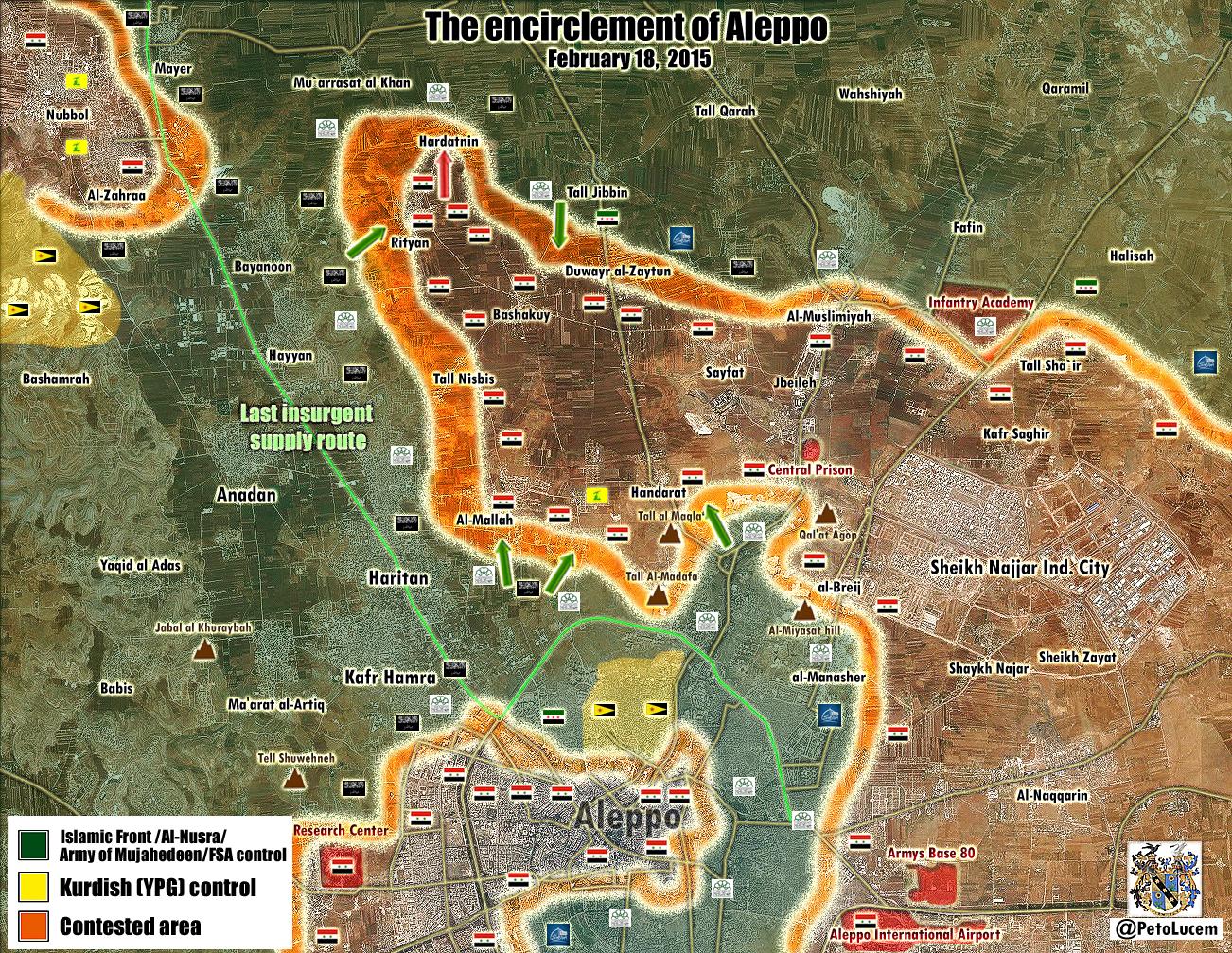
It looks like some more changes to the map are required: Neutral source Al-Monitor describes what appears to have been a large coordinated government offensive around Aleppo. It says regime forces through control of Saifat launched an offensive and captured Hardetneen and Bashkoy, and that ongoing contested fight for Ratyan is taking place: http://english.al-akhbar.com/content/blow-ankara-syrian-army-makes-advances-aleppo-offensive. On the western side of Aleppo, Al-Monitor reports that government forces made advances in al-Maamel and "able to control a number of farms in the west near Haritan and get close to the Castello crossroads, Aleppo’s northwestern entrance which is connected to the international road". It adds "Air Force intelligence forces stationed in the area to advance and control seven urban blocks in the vicinity of the Air Force Intelligence building and al-Rasoul al-Azam Mosque." and that regime army forces "was also able to advance in al-Rashidin al-Rabia" — Preceding unsigned comment added by 169.231.26.49 ( talk) 16:58, 18 February 2015 (UTC)
- New data confirmed that Hardatin and Bashkoy still under control by army. Al Akhbar and Rityan still contested Al Akhbar Documents.sy Hanibal911 ( talk) 17:26, 18 February 2015 (UTC)
The Al Akhbar story covers only events up until around midnight last night. Although the facebook opposition post does confirm more fighting in Rityan. EkoGraf ( talk) 17:53, 18 February 2015 (UTC)
- Last Peto Lucem map, SAA control from the Aleppo City map until the template wider map of Hardatimto the north and Riftian to the East. Aproaching Al-Zara & Nulb.
http://www.almasdarnews.com/article/no-sleep-aleppo-tonight-battle-intensifies-inside-city/#prettyPhoto/0/
200.48.214.19 ( talk) 17:56, 18 February 2015 (UTC)- Jordanian source Aramram Web TV reported that Duwayr Al-Zaytun not was recaptured by rebels and Hardatin still under conrol by army. Aramram Web TV Hanibal911 ( talk) 18:04, 18 February 2015 (UTC)
- Last Peto Lucem map, SAA control from the Aleppo City map until the template wider map of Hardatimto the north and Riftian to the East. Aproaching Al-Zara & Nulb.
Just informative the Insurgents are showing a lot people killed who they claim are soldiers but pro insurgents source (SORH) claim more than 100+ Rebels were killed and only 89 Army troops (Allied Militias included) the day 17/2/15 http://syriahr.com/en/2015/02/221-killed-yesterday-14022015-75-of-them-killed-in-aleppo/ -- LogFTW ( talk) 18:08, 18 February 2015 (UTC)
- Another new report from reliable source said that rebels have taken the Rityan Town.
SOHR.
Lindi29 (
talk) 19:28, 18 February 2015 (UTC)
- In this report SOHR just said that Islamic and rebel factions could capture 15 members of the regime forces during the clashes in the farmlands of Retyan in the north of Aleppo, where the Islamic and rebel battalions could retake the town yesterday night after violent clashes with the regime forces. SOHR So SOHR just says about the events that took place yesterday but not today. But this source that today clashes still continued. here Hanibal911 ( talk) 19:40, 18 February 2015 (UTC)
- Another new report from reliable source said that rebels have taken the Rityan Town.
SOHR.
Lindi29 (
talk) 19:28, 18 February 2015 (UTC)
- SOHR has lost any shade of credibility in this occasion. It has reported Rityan taken by rebels yesterday,
while today and even now many pro-rebel sources has reported of fighting in the town. Even now twtter reports of fighting in the town. Al Masdar and Petolucme reports that half of the town is under SAA control. The lack of consistenty even between pro-rebel sources make impossible to use them, therefore Rityan stays contested till further news clarify the issue. Paolowalter ( talk) 21:47, 18 February 2015 (UTC)
- SOHR's highly questionable post about how the rebels should fight to keep Aleppo free and the storm of rebel propaganda should call in to question ANY information SOHR publishes. So far, no other reliable source has confirmed many of these so called gains claimed by SOHR. Until the issue clears up, I propose a 3 day moratorium on SOHR for Aleppo editing and use only reliable sources such as EJM, Al-monitor, and Edward Dark. Paolowalter, could you change Rityan to contested, I believe I have used up my edit for the day. Thanks XJ-0461 v2 ( talk) 22:27, 18 February 2015 (UTC)
The battle map for Rif Aleppo needs to be updated to reflect the situation. Even though the situation is fluid in Raytan and Hardatinin, the map doesn't encompass most of those areas and therefore should be updated. HarrySy ( talk) 00:50, 19 February 2015 (UTC)
- That is precisely the problem. The situation is TOO fluid for an update. There is too much propaganda in the air coming from many sources, including our "reliable" SOHR [Riytan was recaptured twice, interesting...]. No reliable, neutral sources such as EJM or Al-Monitor have reported such success for the rebels. What we know is that the rebels have launched a counter offensive, what we do not know is how successful they were. I would give the situation maybe two days before their offensive goes out and we can accurately judge.
XJ-0461 v2 (
talk) 00:59, 19 February 2015 (UTC)
- I agree with the amount of misinformation floating around and it is best to wait and see what happens. Regarding Reytan though, I believe it best to leave it as contested for now; pro-gov al-Masdar reporting 80% of Reytan has been captured by rebels/Nusra and NDF is still holding on to the NW part of the village.
HarrySy (
talk) 01:11, 19 February 2015 (UTC)
- According to data from reliable source
Elijah J. Magnier
Elijah J. Magnier
SOHR and pro oppsition source
Syrian Rebellion Observatory (Cedric Labrouse) rebels recaptured Rityan but Hardatin and Baskuy still controlled of army also clashes near the village of Hardatin.
Hanibal911 (
talk) 09:47, 19 February 2015 (UTC)
- The SAA has indeed retreated from Rityan but maintains control over Hardatin and Pahsqoy while Duwar al Zaytoun is contested and Muarrasat is rebel-held. [15]. This has been a Pyrrhic victory for the SAA. About 70 killed and 30 captured for 2 villages. The rebels also suffered slightly higher casualties despite being defenders. ChrissCh94 ( talk) 10:48, 19 February 2015 (UTC)
- According to data from reliable source
Elijah J. Magnier
Elijah J. Magnier
SOHR and pro oppsition source
Syrian Rebellion Observatory (Cedric Labrouse) rebels recaptured Rityan but Hardatin and Baskuy still controlled of army also clashes near the village of Hardatin.
Hanibal911 (
talk) 09:47, 19 February 2015 (UTC)
- I agree with the amount of misinformation floating around and it is best to wait and see what happens. Regarding Reytan though, I believe it best to leave it as contested for now; pro-gov al-Masdar reporting 80% of Reytan has been captured by rebels/Nusra and NDF is still holding on to the NW part of the village.
HarrySy (
talk) 01:11, 19 February 2015 (UTC)
Elijah J. Magnier is just reporting a pro-opp map. I'd not take it as a reliable statement. Paolowalter ( talk) 10:43, 19 February 2015 (UTC)
- Rebels recaptured village Hardatin and now clahses near the village Rityan.
SOHR
Hanibal911 (
talk) 11:05, 19 February 2015 (UTC)
- So Hardatin to contested. ChrissCh94 ( talk) 11:27, 19 February 2015 (UTC)
Editor that reverted the Aleppo map should be band for gross vandalism . Pyphon ( talk) 15:49, 19 February 2015 (UTC)pyphon
- But later SOHR reported that the village of Hardatin still controlled by army but clashes still around this village and also helicopters dropped ammo and supplies for regime forces in village Herdatin. SOHR Hanibal911 ( talk) 15:56, 19 February 2015 (UTC)
SOHR today said Hardetin completely under rebel control and helicopters drop ammo to saa inside Hardetin HAHA . Pyphon ( talk) 16:17, 19 February 2015 (UTC)pyphon
- It is possible that the first report was erroneous. So no need to be ironic.
Hanibal911 (
talk) 16:30, 19 February 2015 (UTC)
- Original report from SOHR reported that clashes in Hardatin still continued and helicopters dropped ammo and supplies for regime forces in village.
SOHR Also previously reliable source reported that rebels recaptured most part of Hardatin village. But group of regime forces are still besieged inside the village and clashes are still ongoing.
The Daily Star So it is clear means that earlier today the rebels not fully captured Hardatin and clashes still continued.
Hanibal911 (
talk) 16:51, 19 February 2015 (UTC)
- Also according to data from the rebel leader villages of Dweir al Zaytun and al-Mallah still contested between Syrian troops and rebels and village of Bashkuy under control by army. Archicivilians It also confirms that SOHR yesterday hastened when reported that village Dweir al Zaytun was captured a rebels. Hanibal911 ( talk) 17:55, 19 February 2015 (UTC)
- Original report from SOHR reported that clashes in Hardatin still continued and helicopters dropped ammo and supplies for regime forces in village.
SOHR Also previously reliable source reported that rebels recaptured most part of Hardatin village. But group of regime forces are still besieged inside the village and clashes are still ongoing.
The Daily Star So it is clear means that earlier today the rebels not fully captured Hardatin and clashes still continued.
Hanibal911 (
talk) 16:51, 19 February 2015 (UTC)
- The correspondent Edward Dark which writes for the reliable sources Al Monitor and Middle East Eye reported that said that village Rityan is on front line now and that a towns which were previously captured army still under regime control, supply line from Turkey to rebel-held east Aleppo still cut. here Hanibal911 ( talk) 18:36, 19 February 2015 (UTC)
Pro rat map here https://pbs.twimg.com/media/B-MNvFlIIAAc752.jpg:large could be true seems Al Qaeda got fresh terrorists from Turkey and were able to recapture part from lost grounds be patient and wait the new lucem Map their maps always are 99,99% right -- LogFTW ( talk) 18:35, 19 February 2015 (UTC)
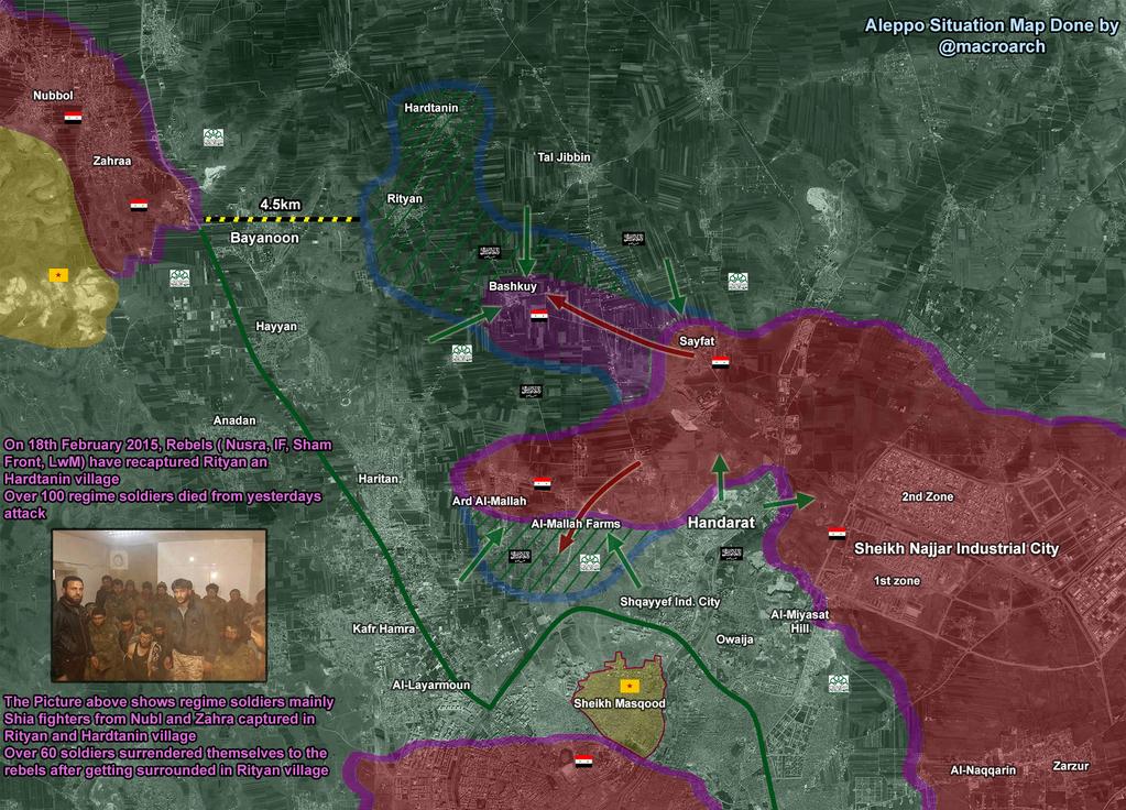
- Pro opposition source about which you said later published new map on which showed that Bashkuy under control by army and Hardathin and Duwayr al Zaytun still contested. here and pro opposition source Archicivilians also reported that Duwayr al Zaytun still contested. here Hanibal911 ( talk) 19:01, 19 February 2015 (UTC)
Be patient it can be very long like Mork /info/en/?search=Battle_of_Mork officially the Syrian authorities and official Sources said nothing abut the situation they will be talk if they gain something and are 100% sure of that -- LogFTW ( talk) 19:48, 19 February 2015 (UTC)
- Here new map from the pro government source Al Masdar Hanibal911 ( talk) 20:37, 19 February 2015 (UTC)
- More precisley, Al Masdar states that "recapturing almost all of Ratyan" (Rytan contested or red half ring on east), Bashkawi and Hardatineen unde SAA/NDF control, not contested but with Gray ring around West and NW respectively, Duwayr al Zaytun and Khan Thouma unde SAA control (with gree-gray ring on the north). That makes sense and is not contraddicted by other sources. There is, as usual, some difference between pro-opp and pro-gov about a village being contested or simply on the frontline (ring). I guess we should adopt this situaton and wait further news.. Paolowalter ( talk) 07:20, 20 February 2015 (UTC)
From SOHR SAA is still located on the outskirt of Ratyan "Retyan Farmlands" as stated by Al Masdar. Maybe still contested? Paolowalter ( talk) 07:29, 20 February 2015 (UTC)
-
Paolowalter
Hanibal911
[16] TheDailyStar (pro-opp) saying regime controls Pashqwi and Hardatin, but it is besieged in the latter.
ChrissCh94 (
talk) 09:44, 20 February 2015 (UTC)
- And the source The Daily Star at the bottom of article provide a link to the pro-opposition sources where source was take those data.
The Syrian Network
Hanibal911 (
talk) 10:01, 20 February 2015 (UTC)
- Also as I mentioned earlier! The reliable source Edward Dark said that village Rityan is on front line now but other towns which army early gained still under regime control, supply line from Turkey to rebel-held east Aleppo still cut. And rebels aslo reported that Dweir al Zaytun still contested and Bashkut under control by army and not besieged. Archicivilians and pro government source also showed that Bashkuy and Hardatin under control by army and that Bashukuy not besieged and Hardatin not totally besieged. here Only pro oppostion source said that Hardatin totally besieged. Hanibal911 ( talk) 10:18, 20 February 2015 (UTC)
- And the source The Daily Star at the bottom of article provide a link to the pro-opposition sources where source was take those data.
The Syrian Network
Hanibal911 (
talk) 10:01, 20 February 2015 (UTC)
-
Paolowalter
Hanibal911
[16] TheDailyStar (pro-opp) saying regime controls Pashqwi and Hardatin, but it is besieged in the latter.
ChrissCh94 (
talk) 09:44, 20 February 2015 (UTC)
- 20 February 2015.
- The beheaders claimed they controlled Al Mallah http://syriahr.com/en/2015/02/rebel-and-islamic-fighters-take-a-full-control-on-al-mallah-and-kill-23-soldiers-from-regime-forces/
- New recent source according Lucem Fighting continued in Al Mallah and Army controlled Hardatin https://twitter.com/PetoLucem/status/568807707479834624 -- LogFTW ( talk) 17:22, 20 February 2015 (UTC)
-
LogFTW Peto Lucem is a pro-regime source and in this case we cant use this source to show advances for the regime.
Lindi29 (
talk) 17:54, 20 February 2015 (UTC)
- SOHR just said that rebels captured the Al Mallah farms and that clashes continue between Syrian army and their allies against rebels and Al Nusra in the vicinity of the villages of Herdatin, Bashkuy and Handarat.
SOHR
SOHR
Hanibal911 (
talk) 17:57, 20 February 2015 (UTC)
- Well SOHR reported clashes in Hardatin while pro-gov sources denied this and said clashes are on the outskirts of Rityan and Hardatin with Pashqoi Hardatin Handarat and Sifat fully controlled while in Mallah they lost about 2 farms out of 48. Rebels meanwhile claim to reach the outskirts of Handarat after fully capturing al Mallah farms (for the 10th time maybe).
- So my recap on the situation: rebels hold Rityan and captured some farms in Mallah while regime forces maintain control over Pashqoi and Hardatin. Regime casualties are about 80 dead and 30 captured and it's about 90 dead for the rebels and 40 captured (SOHR claim). Pyrrhic victory for the regime, slight morale boost as well but the rebels have successfully regrouped, counter attacked and halted the regime offensive. 2 things surprise me: first how the rebels, being defendants, suffered so many casualties in friendly territory and second, how the regime also suffered substantial casualties in what seems to be the first "not-carefully-planned" regime offensive in Aleppo. Both sides know that this battle is the most important one yet.
ChrissCh94 (
talk) 18:24, 20 February 2015 (UTC)
- ChrissCh94 A small clarification SOHR just said that clashes in the vicinity of the villages of Herdatin but not said that clashes inside village of Hardatin. SOHR Hanibal911 ( talk) 18:33, 20 February 2015 (UTC)
- So my recap on the situation: rebels hold Rityan and captured some farms in Mallah while regime forces maintain control over Pashqoi and Hardatin. Regime casualties are about 80 dead and 30 captured and it's about 90 dead for the rebels and 40 captured (SOHR claim). Pyrrhic victory for the regime, slight morale boost as well but the rebels have successfully regrouped, counter attacked and halted the regime offensive. 2 things surprise me: first how the rebels, being defendants, suffered so many casualties in friendly territory and second, how the regime also suffered substantial casualties in what seems to be the first "not-carefully-planned" regime offensive in Aleppo. Both sides know that this battle is the most important one yet.
ChrissCh94 (
talk) 18:24, 20 February 2015 (UTC)
- Well SOHR reported clashes in Hardatin while pro-gov sources denied this and said clashes are on the outskirts of Rityan and Hardatin with Pashqoi Hardatin Handarat and Sifat fully controlled while in Mallah they lost about 2 farms out of 48. Rebels meanwhile claim to reach the outskirts of Handarat after fully capturing al Mallah farms (for the 10th time maybe).
- Also Zaher Saket the brigadier general of the chief of military council in Aleppo just said that town Raytan in Aleppo northern countryside under control by rebels. And nothing more.
Qasion News
Hanibal911 (
talk) 18:38, 20 February 2015 (UTC)
- Also reporter from Aleppo Khaled Iskef states that al Mallah farms are still in control of Syrian army and rebels only take 2 out of 48 farms.
here
Hanibal911 (
talk) 18:42, 20 February 2015 (UTC)
- Yes I know but those are only pro-gov sources. As for SOHR they said clashes are around Hardatin and they never announced a rebel takeover so revert Hardatin to SAA-held but mark part of Mallah as contested. ChrissCh94 ( talk) 19:07, 20 February 2015 (UTC)
- Also reporter from Aleppo Khaled Iskef states that al Mallah farms are still in control of Syrian army and rebels only take 2 out of 48 farms.
here
Hanibal911 (
talk) 18:42, 20 February 2015 (UTC)
- SOHR just said that rebels captured the Al Mallah farms and that clashes continue between Syrian army and their allies against rebels and Al Nusra in the vicinity of the villages of Herdatin, Bashkuy and Handarat.
SOHR
SOHR
Hanibal911 (
talk) 17:57, 20 February 2015 (UTC)
- Here new maps from the pro government source Petro Lucem and from the pro opposition source Archicivilians Hanibal911 ( talk) 19:49, 20 February 2015 (UTC)
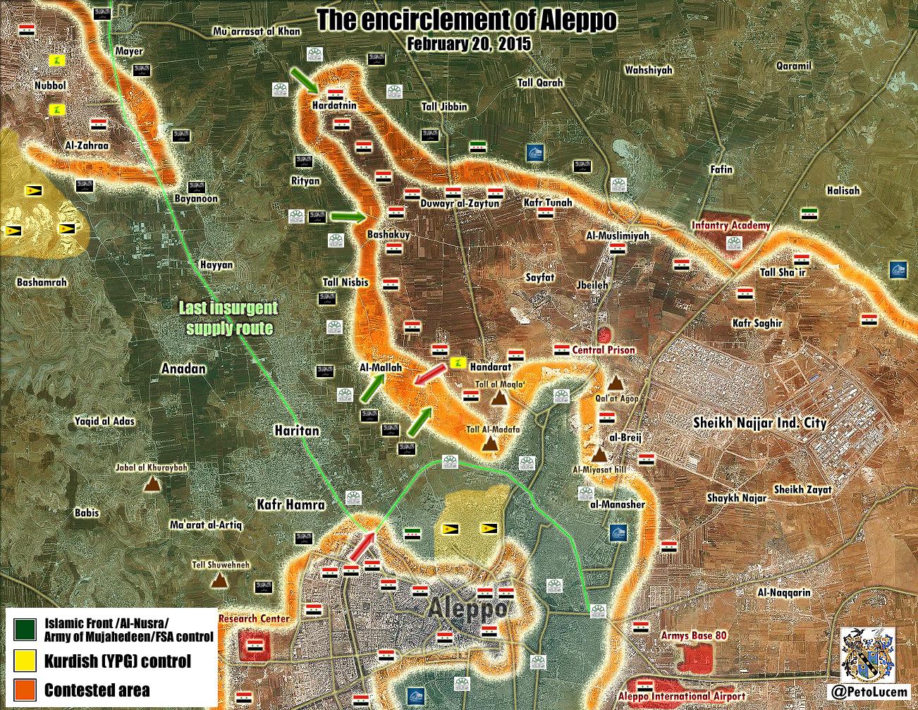
Aleppo city map needs to reflect saa advance northward . Pyphon ( talk) 20:13, 20 February 2015 (UTC)pyphon
Read new Edward Dark article it says this government offensive was hastily prepared. They had no artillery or airport and only a few tanks- It was almost all infantry for a surprise attach. My guess is probably because satellites and drones etc feeding backing intelligence to rebels (through turks,us,etc) would not expect an offensive without artillery,etc. So the infantry were somewhat successful but only partially. http://www.middleeasteye.net/columns/new-aleppo-offensive-assad-afraid-french-and-turkish-retribution-1528131
- Albasha Rida the reporter from the Al Mayadeen reported that Syrian troops and NDF withdrew from the village Hardatin after rebels cut the supply line to the village.
Rida Albasha also pro opposition source said that earlier today Al Nusra took all of Mallaah and the Farms from regime, who had 50% and now regime retook some part of Farms.
here
Hanibal911 (
talk) 22:11, 20 February 2015 (UTC)
- SOHR also confirmed that clashes in Al Mallah still continued. SOHR Hanibal911 ( talk) 22:19, 20 February 2015 (UTC)
Then why now Herdatin is marked green and not contested??! I can´t even find a pro-rebell source that says so. Rhocagil ( talk) 22:19, 20 February 2015 (UTC)
-
Rhocagil Albasha Rida the reporter from the Al Mayadeen(pro gov) reported that Syrian troops and NDF withdrew from the village Hardatin after rebels cut the supply line to the village.
Rida Albasha and also pro opposition source also said that Hardatin under control by rebels.
Archicivilians
markito0171
Hanibal911 (
talk) 22:26, 20 February 2015 (UTC)
- Here another pro opposition source also reported that Syrian troops held a counter-attack and recaptured a part of the al Mallah farms.
here
Hanibal911 (
talk) 22:33, 20 February 2015 (UTC)
- Reliable source said that not all Al Mallah was taken by rebels and Al Nusra because Syrinarmy still in Mazare' Mallah. Elijah J. Magnier And source also said that Army still preparing to push more force and back into the battle filed and that would reconquer the lost territory. Elijah J. Magnier Also pro opposition source confirmed that Bashkuy still under control by army Duwayr Al Zaytun contested and army still controlled some areas in Al Mallah and clashes still continued here Syrian Rebellion Observatory Hanibal911 ( talk) 10:50, 21 February 2015 (UTC)
- Here another pro opposition source also reported that Syrian troops held a counter-attack and recaptured a part of the al Mallah farms.
here
Hanibal911 (
talk) 22:33, 20 February 2015 (UTC)
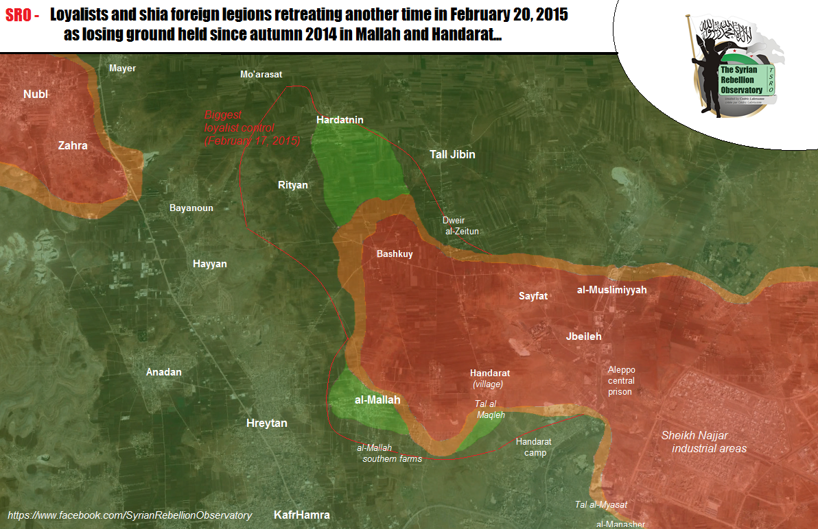
-21/2/15- Lucem updated https://pbs.twimg.com/media/B-YhIakIUAAYLf1.jpg:large
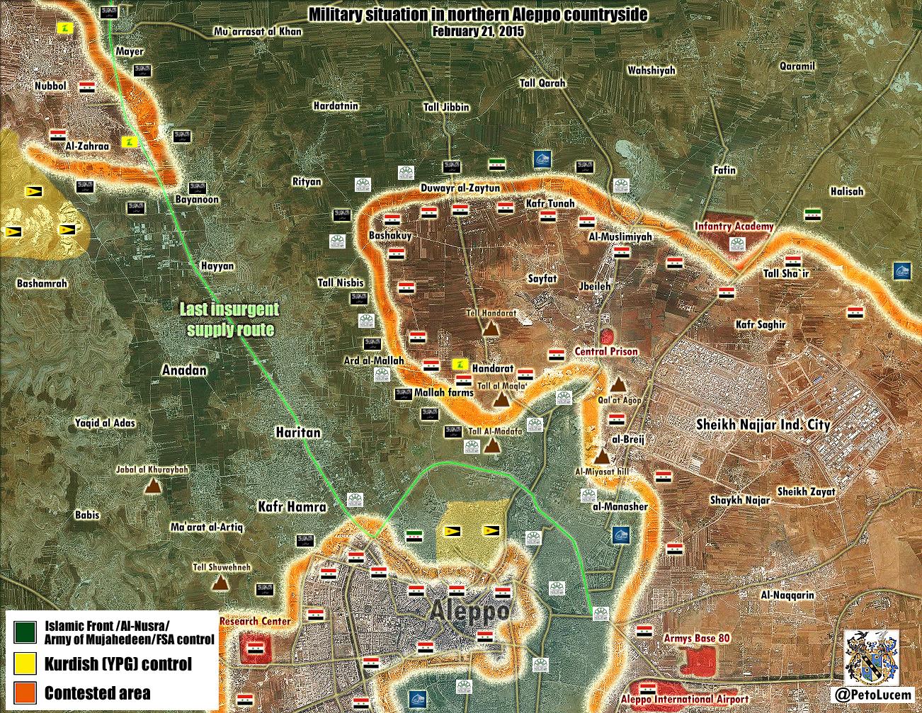
As I know according to the information able as now =
- The beheaders retake and controlled Rityan and Hardatnin
- The beheaders retake the major part from Al Mallah (Basically all of it area captured by the Army in 2014)
- Army captured Army captured Bashakuy
Is very clear the beheaders got news terrorist from Turkey (As is usual when they are in troubles) - the zone is very important for them and is defended by the best beheaders Chechen and Uzbek mostly http://www.liveleak.com/view?i=667_1424459492
If it's finish the attempt to finish the beheaders in Aleppo zone failed at the moment, too many causalities and lost grounds
Troops poorly equipped, lacking of Tanks / APCs / IFVs
It can continue but at the moment that look as a total shit for the Army -- LogFTW ( talk) 18:48, 21 February 2015 (UTC)
Hardatin
There is this report [17] stating that Hardatin is under SAA control. I changed it accordingly. Paolowalter ( talk) 18:17, 20 February 2015 (UTC)
From Al-Masdar some more info. Paolowalter ( talk) 20:27, 20 February 2015 (UTC)
- Albasha Rida the reporter from the Al Mayadeen reported that Syrian troops and NDF withdrew from the village Hardatin after rebels cut the supply line to the village. Rida Albasha Hanibal911 ( talk) 21:40, 20 February 2015 (UTC)
Syria24 says different .saa release 48 prisoners from rityan and break siege of hardetin . — Preceding unsigned comment added by Pyphon ( talk • contribs) 19:40, 21 February 2015 (UTC)
Um Sharshouh
Who changed Um Sharshouh red? It is on the front line but nont under SAA control AFAK, see e.g. SANA. I guess contested is correct. Paolowalter ( talk) 22:20, 21 February 2015 (UTC)
-
Paolowalter Pro opposition source confirmed that village controlled of army.
Qasion news
Hanibal911 (
talk) 10:17, 22 February 2015 (UTC)
- So what if they have barriers inside the town that doesn't mean they fully control the town. And no pro-regime source ever mentioned a takeover. Revert it back to contested.
ChrissCh94 (
talk) 10:22, 22 February 2015 (UTC)
- Done
Hanibal911 (
talk) 10:40, 22 February 2015 (UTC)
- So what if they have barriers inside the town that doesn't mean they fully control the town. And no pro-regime source ever mentioned a takeover. Revert it back to contested.
ChrissCh94 (
talk) 10:22, 22 February 2015 (UTC)
Suwayda
According to Al-Masdar report the SAA just secured the Khalkhalah Airport and captured 2 villages Tal-Asfar and Tal-Delfa from Isis and Al-Nusra members. almasdar,in this case de-Syracuse reports were right, de-Syracuse. Lindi29 ( talk) 22:00, 21 February 2015 (UTC)
- Al Masdar not said that Syrian army recaptured villages Tal-Asfar and Tal-Delfa. Source just said that army protects these villages from possible atack ISIS and some Al Nusra fighters which joined to ISIS in the surrounding villages east of the besieged area; this includes Tal Asfar and Tal Delfa.
Al MasdarSo source clearly said that this villages Tal Asfar and Tal Delfa also located in area which besieged ISIS. But not said that this villages controlled ISIS. And SOHR just said that clashes erupted between the regime forces against the rebel and Islamic battalions around of Tal al- Asfar region.
SOHR
Hanibal911 (
talk) 10:14, 22 February 2015 (UTC)
- So Al Masdar and SOHR juse said that ISIS located around of Tal al-Asfar region. Also Tal-Delfa it is not village it is military object which is under control by army this earlier confirmed the pro opposition source. Archicivilians and Tall Asfar not village it is also military object. But only antigovernment sources reported that military object Tall Asfar and the village of Al Haqf under control by ISIS. Archicivilians deSyracuse But we cant use data from this source in this issue. Need data from neutral source. Hanibal911 ( talk) 10:54, 22 February 2015 (UTC)
I revert changes in Al Haqf and put Tall Asfar contested based on SOHR infos. I have no strong opnion on this point. If there are different opinion, please edit accordngly. Paolowalter ( talk) 15:58, 22 February 2015 (UTC)
Bashmara in Afrin
The village of Bashmara was as late as 2015-01-29 still in YPG hands, when people celebrated liberation of Kobane from ISIS. It was yesterday changed to green providing a vague map. When Bashmara came into islamists' hands and no one knew about it? This Kurdish village is still in YPG control. Roboskiye ( talk) 09:25, 19 February 2015 (UTC)
- Ignoring the fact that green doesn't mean islamist (although the caption of that map favours that designation), this shows the folly of using an unannotated map to show changes of control.
- The map is also from a partisan pro-regime source, thus even if properly annotated (with times for each change of control), it should never be used alone to show regime gains.
- This also underlines the weakness of our current free-for-all approach to maintaining the map. Originally changes were made to the tables as the map was updated, so we had documentation of the current map display. According to WP policy, it would be legitimate to revert the map to the latest documentation in the tables. Which for most locations, is sometime in 2012.
- When I have more time, I'll propose a modification of our procedures (and the tables) to facilitate a documented and more accurate map. If someone else doesn't beat me to it. André437 ( talk) 11:12, 19 February 2015 (UTC)
- BTW, 99,99% of FSA are hardscore islamists, no matter which ethnicity they belong to. In fact, secular Arabs are with Bashar and secular Kurds with YPG. Back to the topic, there is not a single source for islamists have recently clashed with YPG and captured Bashmara. Roboskiye ( talk) 15:23, 19 February 2015 (UTC)
FSA Are in the practice Al Qaeda terrorists and YPG is secular but sectarian and want created de facto Kurdish State in Syria this made them de facto Against the Syrian state that's because the Kurdish separatists and FSA (AL Qaeda) are allied in severals areas of the country, in other zones FSA - YPG Killed each others in the practice all are illegal armed gangs who used the bad situation in Syria since 2012 for their own benefits -- LogFTW ( talk) 18:05, 19 February 2015 (UTC)
- Pro opposition and pro government sources confirmed that area wher located village of Bashamrah now controlled by moderate rebels or Al Nusra. Petro Luce and Syrian Rebelion Observatory(Cedric Labrousse) But you can decide how to use these data. Hanibal911 ( talk) 18:21, 19 February 2015 (UTC)
Cedric Labrousse's map actually ommits any presence of YPG forces even north of Bashmara and in Aleppo city which indicates he's just marking everything yellow as green, as he is known to be a supporter of the idea of YPG joining up with the Opposition and all.
I would vote for putting Bashmara again in yellow color at the very least until there are more sources than just maps for whose purpose the rebel-kurdish distribution of land is irrelevant, specially as there is less than one month ago proof of the village being under PYD administration.
186.119.56.230 ( talk) 04:13, 20 February 2015 (UTC)
According to this guy with close links to jabhat al akrad he claims that Jabhat al akrad kurds controll tatmarash which is rebel held in this map. Also Deir jemal city is joint jabhat al akrad/YPG held but they let rebels use the countryside of deir jamal to target assad.
https://twitter.com/sergermed/status/560578422511259648 -- Creepz55 ( talk) 16:14, 22 February 2015 (UTC)
Daraa NW
From Al-Masdar: Tal Fatima is red, Zimreen with red ring or contested (it is already), the rest confirm what is on tha map. Paolowalter ( talk) 20:42, 20 February 2015 (UTC)
Need a neutral source or pro op . Pyphon ( talk) 21:23, 20 February 2015 (UTC)pyphon
- Paolowalter pro opposition activist also said that now going clashes to east from village Zimrin and to north from Simlin. here In this area located positions of the Syrian troops. here Hanibal911 ( talk) 21:32, 20 February 2015 (UTC)
- Tel Fatima was turned gray on the basis of Al Mansar news [18], then the same source reported the reconquer by SAA. It is somewhow backed up by SOHR that reports fighting in the area. Hard to believe we need additional sources when the same source reports a reverse to the previous situation. Paolowalter ( talk) 10:31, 21 February 2015 (UTC)
Zimreen can be put with a red ring, because the same Al Masdar report as surrounded and pro-opp reports fighting around it. Paolowalter ( talk) 10:31, 21 February 2015 (UTC)
In [19] I remarked that Himrit was reported under SAA control as reported by Al Mansar and [ https://twitter.com/IvanSidorenko1/status/566407330636787714 IvanSidorenko]. It was not considered sufficient but it was turned contested based on SOR report (I guess). No fighting has nee reported there since a week ago. Is it OK to turn it red now? Paolowalter ( talk) 13:34, 21 February 2015 (UTC)
Here is some fresh news from pro gov almasdar, pro rebel wasn't publish any concrete news in last few days ( 83.26.144.144 ( talk) 13:49, 22 February 2015 (UTC))
-
Paolowalter deSyracuse source showed situation on 9 February
here and showed that Himrit under control Syrian army but source al Masdar of 13 February reported that army captured village Himrit.
al MAsdar So that this source is newer and confirms that this village until 13 February was as contested. But according to the rules of editing we cant use pro-government sources to display success of army. So need data from pro opposition or neutral source that this village under control by army. Here pro opposition source which showed situation on 11 February showed that Himrit contested
Syrian Rebellion Observatory (Cedrik Labrouse) So as I said earlier need confirmation from a neutral source.
Hanibal911 (
talk) 20:30, 22 February 2015 (UTC)
- Hanibal911 the biggest problem of this report and these maps is that they were from 9-11 february, today is 22 february and we have not any pro oposition source which say something about situation in NW Darra, only about offensive in Tall Fatima hill. ( 217.99.151.213 ( talk) 20:48, 22 February 2015 (UTC))
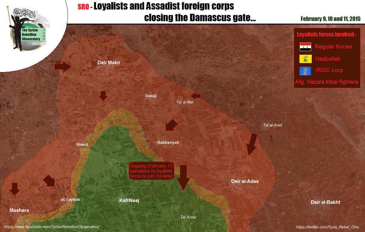
| This is an archive of past discussions. Do not edit the contents of this page. If you wish to start a new discussion or revive an old one, please do so on the current talk page. |
| Archive 35 | ← | Archive 40 | Archive 41 | Archive 42 | Archive 43 | Archive 44 | Archive 45 |
Size of map
Can anyone reduce the size of the map at the top of the page? It seems overly large to me. Natg 19 ( talk) 20:12, 12 February 2015 (UTC)
- That depends of your PC Display, however you ae not the first one demanding a reducction of the map, the problem with this its that some small but strategicaly important villages will not be visible. 200.48.214.19 ( talk) 20:52, 12 February 2015 (UTC)
Reduce lol ? I have a standard laptop 15,5 inch monitor and the map is really small, i have to zoom the page to 130% to barely see the villages ... does anyone else think that the map should be zoomed in ? DuckZz ( talk) 21:55, 12 February 2015 (UTC)
- That depend of your PC Display or browser in my work break, some PC show the map extremely huge. But it depends of the computer. The main reason i find redusing the size of the map impossible its that some villages would be imposible to see. 200.48.214.19 ( talk) 13:48, 13 February 2015 (UTC)
- The map is much larger than any normal screen resolution. If not "adjusted" by the browser, you should only see a small part of the map at a time. (This is by design, to allow showing more locations on the map.)
- Many browsers are able to resize the map (or any other inset like the map) to the size of the screen. If that happens for your browser, you should zoom it to at least 250% to see it full size. It probably is configurable in the browser settings.
- Mozilla browsers (like firefox, seamonkey, etc) won't do this for our map (at least not by default), so that can be corrected if it happens with such browsers. It is better to avoid automatic resizing + subsequent zooming, as likely the display will be less clear.
- Hope that helps ... André437 ( talk) 04:21, 14 February 2015 (UTC)
Himrit
Himrit is under SAA control [1]. Paolowalter ( talk) 07:13, 13 February 2015 (UTC)
- Even though the credibility of Al-Masdar has improved quite alot in recent months, I think we should wait for 1 more source, neutral or pro-opp to confirm the event since the area is quite a hotspot at the moment.
ChrissCh94 (
talk) 10:06, 13 February 2015 (UTC)
- Agreed with ChrissCh94 we need confirmation from pro opposition source or neutral source. Hanibal911 ( talk) 10:46, 13 February 2015 (UTC)
- Is that sufficient?
https://twitter.com/IvanSidorenko1/status/566407330636787714
Paolowalter (
talk) 10:48, 14 February 2015 (UTC)
- I would say so. The rebels have been awfully silent about the situation so far, suggesting that it is true. What do the other editors think? XJ-0461 v2 ( talk) 17:17, 14 February 2015 (UTC)
Talbiseh
Again fighting in Talbisah SOHR. Time to switch it contested. Paolowalter ( talk) 13:29, 13 February 2015 (UTC)
- Talbiseh is a rebel stronghold. It is not contested. Just south of the city there is the Malouk army complex from which army troops attack the border of the city. This has been going on for months, but the rebels are holding up well... so the city is not contested & the clashes can still be reported routinely for months in the future along the same pattern. No evidence that army troops can do anything other than hit & run attacks. The red semi-circle is enough for now. Tradedia talk 13:52, 14 February 2015 (UTC)
You are not producing any evidence to support your claims. The rule states that if figting are rerported by pro-opp source in a city controlled by opposition (SAA advance) we must mark it on the map. This source openly talks of clashes 'in al- Hlaleyyi and Hosh Hajjo areas in the city of Talbise.' Similar statements were reported several times in the past. Paolowalter ( talk) 16:06, 14 February 2015 (UTC)
- I do not need to produce any evidence. There are plenty of sources that were produced in the past and there is a consensus about it. The sources say that Talbise is rebel-held & describe in details the situation in it & around it. You are the one who has to produce evidence that the status of the city has changed from the past. The “rule” you mention does not exist. We mark a city contested if it is contested. Talbise is not, and we had reports of “clashes” before but never marked it as contested because it is not. Clashes could be hit & run attacks and that does not make a city contested. You mention the expression “SAA advance”, however in this case, there is no evidence for such an advance (or SAA occupation of a part of the town). For small towns that we know nothing about, we might put them on the map as contested based on clashes report, because this might be the only information we will get about them. Talbise is an important strategic city. If it becomes contested, we will hear that it is contested because it is important news. Does any source (including pro-gov) claim that it is contested or that army is making progress in it? No. It is not more contested than nubl or zahraa were. We turn a town contested based on clashes report if we don’t know the previous situation in the town or we hear about some kind of an offensive by one of the parties. Contested means we cannot say one specific side controls it. In this case, we can say rebels control it. Tradedia talk 22:10, 14 February 2015 (UTC)
Khurus Kobane
Khurus village in kobane close to qara qawzaq should be contested and not isis held.
https://twitter.com/archicivilians/status/565257184855220228 -- Creepz55 ( talk) 16:37, 13 February 2015 (UTC)
- You are right, but this source is 3 days old and no other sources (not even YPG official media) have said nothing about it 8fra0 ( talk) 17:59, 13 February 2015 (UTC)
Pro-Kurdish source from inside Kobane says YPG are not in control of Xerab Eto but that clashes are ongoing, please change to contested:
https://twitter.com/jackshahine/status/566616553148661760
He also reports that clashes are going on near Jadah village:
https://twitter.com/jackshahine/status/566585598602129408
It would be a YPG advance but would it be acceptable to mark it as besieged from North?
179.33.157.37 ( talk) 16:25, 14 February 2015 (UTC)
- Jack Shahine statements have always been very reliable in the past weeks, I think that he could been used as a permanent source for editing this map. So Xerab Eto is contested and Jadah, Kuraftar and Turaman are in YPG hands, I would add those villages rather than marking Khurus besieged -- 8fra0 ( talk) 17:28, 14 February 2015 (UTC)
- I have edited Xerab Eto and added Jaadah contested, let's wait for further developments -- 8fra0 ( talk) 17:39, 14 February 2015 (UTC)
Zor Mexar and Bayadiya CONTESTED not YPG controlled according to jackshanine quoted by another kurdish activist:
https://twitter.com/ArjDnn/status/566735706987704320
179.33.157.37 ( talk) 23:11, 14 February 2015 (UTC)
Masharah
According to this twitter source Masharah is contested here but according to this video it shows rebel attacking Tall Bzaq from the northren outsikrts of Mashrah here, but in the map this town is Regime held ? Lindi29 ( talk) 22:47, 13 February 2015 (UTC)
they will say, we need a source, not videos. Alhanuty ( talk) 23:04, 13 February 2015 (UTC)
- You are Right :) XJ-0461 v2 ( talk) 23:13, 13 February 2015 (UTC)
Dear Lindi29,
You will achieve nothing. The chief editors here will claim Twitter is no source. However, they will use Twitter themselves if it showes SAA advances. Also, you need at least 3 sources for any rebel advance, whilst adding red semicircles and contested icons for a SAA advance needs only 1. You would do better to make your own map of follow Twitter maps, because we won't achieve any neutrality in southern Syria on this one ... regretfully. — Preceding unsigned comment added by 84.24.43.183 ( talk) 10:10, 14 February 2015 (UTC)
Hahaha the double standard idiots crying, ooo my god iranians are fighting with SAA and afghans, meanwhile jihadists from 83 countries are fighting in the ranks of the snackbars. They are using NEUTRAL UNBIASED sources like Elijah who got info FROM THE GROUND without any media or activist bias. He knows everything before it reaches the media. It was clear that Deir al adas was taken by SAA cause there were videos from the city. Not biased archivilians and al qaeda supporter markito twitter LOL Totholio (talk | contribs)
- This is a tweet of the international correspondent Elijah J. Magnier of Kuwait News Agency. But markito0171 and archicivilians opposition sources and we cant use their data to show the success of the rebels. So you 84.24.43.183 always criticize the changes made to the favor army but nothing said when the we used data from Twitter to display the progress of rebels and ISIS. So it's a clear indication that you are fully supported rebels and opposed the army. So what is your opinion biased and not objective. But I try to be objective and observe the rules of editing. Hanibal911 ( talk) 12:46, 14 February 2015 (UTC)
- It is just pro opposition source and we cant use this source to displayed success by rebels. We need data from neutral sources. Also previously pro opposition activist Cedric Labrousse showed that villages of Deir al-Adas, Deir Makir, Mashara and Habbariyah under control by army. Syrian Rebellion Observatory Hanibal911 ( talk) 12:27, 14 February 2015 (UTC)
Let's see what happens. This source has been pusblished: https://now.mmedia.me/lb/en/reportsfeatures/564830-the-assad-regimes-daraa-campaign-is-a-desperate-defensive-maneuver and http://www.huffingtonpost.com/nicholas-noe/the-battle-for-southern-s_b_6668744.html It states that fighting is ongoing around Deir al-Adas, and that the regime has not been able to advance by much. So Kafr Naisj, Tell Antar and Sabsaba should be green since the only real advances of the SAA were around Dayr Makir, Deir al-Adas and near Himrit. Also, we never received neutral sources for Masharah and At-Tayhah. Both are shown as rebel held on multiple maps. Some of you claim those maps are too pro-FSA to use. Well ... they've shown Sabsaba and Himrit under rebel control for months. You editors claimed that was nonsense. And see ... the SAA is attacking right those villages that had been red al along on this map. So those maps were right, PetroLucem was not. I'm predicting: it will be shot down as a source for this map because:
- It's "not detailed enough"
- It's too pro-opposition
- It doesn't fit the mood of the editors, because they don't want to think for themselves
let's see how long it takes before some Al-Masdar, PetroLucem of Elijah Twitter source shows up to make Kafr Shams contested? I say: two days at the most. — Preceding unsigned comment added by 84.31.204.195 ( talk) 13:16, 14 February 2015 (UTC)
- Firstly this source The Huffington Post not said that clashes around Deir al-Adas. And Secondly this source NOW Newd just publish data from the Abu al-Majd al-Zoabi one of the rebel leader in South front. But as I have previously said the pro opposition source Sedric Labrouse confirmed that villages of Deir al-Adas, Deir Makir, Mashara and Habbariyah under control by army. Syrian Rebellion Observatory And this is a tweet Elijah J. Magnier of the international correspondent so it is a reliable source. Hanibal911 ( talk) 13:32, 14 February 2015 (UTC)
- Also previously pro FSA source confirmed that Syrian troops captured part of the town Kafr Nasij. here Hanibal911 ( talk) 13:42, 14 February 2015 (UTC)
Map about Daraa from a source I do not know http://www.mediafire.com/convkey/47c9/txl7ypxdoaa23lbzg.jpg. Can it be used? It confirms Himrit under SAA control as reported by Al Masdar. It is the third source mentionng it, is it sufficient? Paolowalter ( talk) 21:09, 14 February 2015 (UTC)
- Ivan mentioned that an FSA activist confirmed it. Your map, however, cannot be used since it is not authoritative [we cannot guarantee its reliability since be do not know who made it]. XJ-0461 v2 ( talk) 00:01, 15 February 2015 (UTC)
Ma'arrat Hurmah
SOHR reported that clashes in the town of Ma’arret Hermeh in the southern countryside of Idlib between al- Nusra Front and gunmen from the town. SOHR and pro opposition source Syrian Rebellion Observatory reported that Abu Hamoud the chief of Free Police in Maarat Harmah, reportedly killed by a Jabhat al-Nusra and said that It's a new wave of killings from the Al Nusra side since few weeks against local forces (including Free Police) in the Idlib province. Syrian Rebellion Observatory I ask to other editors express their views on this issue. Hanibal911 ( talk) 13:41, 15 February 2015 (UTC)
- For those who dont know the Syrian Rebellion Observatory Syrian Rebellion Observatory it is a new project of the pro opposition activist Cédric Labrousse his former project was is The Arab Chronicle يوميات الربيع العربي, by - par Cédric Labrousse Hanibal911 ( talk) 13:47, 15 February 2015 (UTC)
- I've seen that and am not surprised at these Nusra-rebel conflicts. When Labrousse gets plugged into an area, he tends to have quite reliable info long before other sources. That was the case in Daraa before. Apparently it depends on his local contacts. Before he had a few on line interviews where followers (like myself) could propose questions to local contacts via him in real time. He has the advantage over many western sources that he can at least read arabic.
- He does have the down side of being a little too competitive with other reporters. Also in rapidly changing situations, he sometimes reports before the area has stabilized. (i.e., when a specific location changes hands several times in a short period.)
- As for his reports on various rebel groups, I've had no reason to doubt his info, often later confirmed by other sources. He is writing a book on Syrian rebel groups.
- Anyway, good idea to keep an eye on his new site. André437 ( talk) 20:05, 15 February 2015 (UTC)
Added villages in Homs ,why?
What was the point of adding all those tiny villages in east Homs. If we added all villages of their size in the rest of syria the map would be overloaded . I am in favour of showing small villages if they are on the front line but if not they are pointless . 31.50.78.246 ( talk) 21:50, 12 February 2015 (UTC)pyphon
- Totally agree. Rhocagil ( talk) 01:10, 13 February 2015 (UTC)
- I agree. Even because they are rarely mentioned so that it is almost impossible to be informed if they switch control. Paolowalter ( talk) 07:13, 13 February 2015 (UTC)
I kind of feel the same about the black dots around Saba in Hasakah. Anyway I would like more opinions from others, to maybe get a consensus to remove some of the villages i Homes as they are not in the frontline. Rhocagil ( talk) 14:35, 13 February 2015 (UTC)
- I agree, all the extra black dots don't represent any villages since they're simply hamlets and are of no significant value to any side. Its clutter. MesmerMe ( talk) 17:42, 13 February 2015 (UTC)
The editor who added them obviously wanted to show ISIS control of the area but has got carried away. At least halve of them are not needed. 31.50.78.246 ( talk) 18:15, 13 February 2015 (UTC)pyphon
- The point for add those villgaes is beacause in that area there was a big vacum and also it wasn't showing the frontline I didn't add them myself but I provided source, also adding villages(dots) it makes the map more clearly and easier for people to read.
Lindi29 (
talk) 19:22, 13 February 2015 (UTC)
- It doesn't make it clear since it gives a wrong indication of the map. It currently looks like the area east of Homs is densely populated, which is something not every remotely true. While adding villages isn't a problem, adding 40 at the same time both in Homs and Hasakah give the wrong picture and should be (partly) removed. MesmerMe ( talk) 21:29, 13 February 2015 (UTC)
- MesmerMeLOL.It doesn't make it clear since it gives a wrong indication of the map?,This map is created with reliable sources not by my opinion.Populated?,The regime is on the advance and taking more villages in this area and you are saying they are not populated who are they fighting with Ghosts ?,look even if they are not populated with a great number of people even if it less it doesn't matter beacause this is a war map and we show who is in controll on this places no matter if they regime,rebels,kurds or jihadists.We are not here for giving bad or good pictures but to show who is in controll and that's the truth if you have any reliable sources please provide,beacause the map is very clear. Lindi29 ( talk) 21:52, 13 February 2015 (UTC)
- The point for add those villgaes is beacause in that area there was a big vacum and also it wasn't showing the frontline I didn't add them myself but I provided source, also adding villages(dots) it makes the map more clearly and easier for people to read.
Lindi29 (
talk) 19:22, 13 February 2015 (UTC)
I think the smaller villages you are talking about should be reduced in size on the map, according to satellite and wikimapia of course, to decrease their apparent importance. Not all of them are exactly that size, of course. 2601:0:B200:F7D9:E405:3B3C:3A9A:1531 ( talk) 02:17, 14 February 2015 (UTC)
Lindi29 .You say you provided source so where is it? I have not seen it on here . 81.156.224.112 ( talk) 18:57, 16 February 2015 (UTC)pyphon
New icons are ready for your feedback
They are
here for Nusra, mixed control, truce areas, etc.
Please leave your feedback in that section on my talk page.
Thanks :)
André437 (
talk) 17:08, 15 February 2015 (UTC)
- Let us not score map, for now we have enough icons. The only thing that can be used it is some mixed 3 way
Hanibal911 (
talk) 17:43, 15 February 2015 (UTC)
- For Al Nusra I think we should use this icon.
Although honestly after examining your new icons I think that we can use them. With the exception icons which showed truce I think we have to leave the old version.
Hanibal911 (
talk) 17:59, 15 February 2015 (UTC)
- For Al Nusra I think we should use this icon.
The different icons for bases, checkpoints and strategic hilltops make a lit of sense. It would make the situation presented a lot clearer. MesmerMe ( talk) 19:41, 15 February 2015 (UTC)
I like the triangle mountain peak icon, the cross is not good it could be mistaken for a hospital. Rhocagil ( talk) 20:27, 15 February 2015 (UTC)
- Hanibal911 great pick I like them. Lindi29 ( talk) 21:12, 15 February 2015 (UTC)
I personally like this File:Test-map-dot-grey-676.svg icon. The mixed control icons may seem good, but in reality there would be such a terrible and hardline discussions about which party has presence inside a town and where. This doesn't make sense. And here is why. For example Al Nusra members are present in 80% areas where rebels are, same vice versa. Every icon would be changed, and that wouldn't make sense if a town has 500 JAN members inside and 10-40 IF members too, but we can't know that....
Not sure why people are posting here rather than his talkpage as he asked, but as we've started, I guess I'll post here as well. I'd prefer a colour that looks less like others such as #009900. As for stable mixed control, how is this different from a truce? I would still like to see stable mixed control used, though, as it makes tracking changes easier, and stops pointless debates over which icon should be in the middle and outside of a stable control.
As for the truce icons, I think the usage of the first one looks identical how we use besieged at the moment, though besieged is generally not a truce. I would use this icon to replace the need to use multiple icons. The second one is beyond me, I really don't get why one colour gets the outside and half the middle, is this saying they control the surrounding area and part of the city?
The hill/checkpoints icons seem interesting. I don't think I'd want them to be used as you intended by and large because as far as I can tell there's little demand for them. I'd personally want one them for small settlements/buildings to avoid giving misleading impressions of population distribution. This would also have the benefit of marking points that are unlikely to receive subsequent media attention if captured, so we can more easily spot them. Banak ( talk) 01:10, 16 February 2015 (UTC)
- A first response to your feedback :
- 1) It would be better to come to a consensus on the Nusra colour first, since it is used in a number of new and existing icons. All the options I gave could still be called grey, to simplify naming icons. So far we have one favouring the greenest grey, another the bluest. Remember that Nusra has chosen to put a greyish blue icon in their videos, so it seems better to favour a similar colour.
- 2) The 3-way stable mixed control icons seem to be accepted. That is something that current icons can't show. All the other icons introduced are designed to replace current icons showing the same control.
- 3) Each 2-way stable control icon will replace 3 nested ring icons. There are not many such cases since we added the inset maps for the larger cities. The new pie icons (such as red-lime) are intuitively clearer than nested circles (like red-lime-red or lime-red-lime). As well as being much easier to edit 1 icon instead of 3.
- 4) Note that I'm not adding any new colours. Although Nusra grey will (likely) change.
- 5) We currently use red-lime-red for all truces, which is same as the coding for stable mixed control. The lime truce icon explicitly says "truce with rebel control", using violet from the inset maps for the circle. The red-lime truce icon explicitly says "truce with mixed regime-rebel control". (There may not be currently any such cases outside inset maps.) So these truce icons do serve a useful purpose.
- Note that a truce is a formal agreement to not fight each other. Stable mixed control could be either neither party wants to fight the other (kurds + fsa currently) or that neither party is strong enough to overwhelm the other (kurds + regime in Hasaka)
- 6) One response suggested confusion about the red-lime truce icon. Apparently the violet truce ring is too close to red. Maybe I should change the ring colour to purple, for better contrast ?
- 7) The comment about the "+" (cross) (for hills) being often used for hospitals is a good point. So those icons should be dropped.
- That leaves the little triangles for control of strategic hills. Note that in some areas, such as Daraa, and the mountain areas running from Quneitra to Western Aleppo, such hills are common. Other areas, such as the eastern desert, not at all. So it isn't expected that the hill icon will be usable everywhere. At the moment for example, it will be very useful in Daraa. By having a distinct icon, it gives useful info intuitively. (Almost everyone recognizes the mountain peak symbol.)
- Using such a symbol for other purposes is likely to be misunderstood. But other symbols could be developed if desired.
- 8) A comment made me think of another possible icon for checkpoints : simply a small "CP", in the appropriate colour. Couldn't be mistaken for anything else, and does eliminate the current confusion between (large) bases and (small) checkpoints.
- --- so keep your feedback coming. As items are accepted by consensus, I'll rename them to permanent icons, and mark them as accepted on my talk page.
- I'd like to first finalize the Nusra grey ... André437 ( talk) 09:21, 16 February 2015 (UTC)
Is possible just two color ? -- LogFTW ( talk) 12:43, 16 February 2015 (UTC)
- André437The mixed control icons are great it's a pain to get these 3 inner circles on the map and displayed correctly especially with the smaller villages. I applied these icons on the Libyan civil war map : /info/en/?search=Module:Libyan_Civil_War_detailed_map/doc and already it looks much better. One icon is missing though the Grey/Lime/Black stable situation. Spenk01 ( talk) 16:44, 17 February 2015 (UTC)
Tradedia Totally agree with your critique of the checkpoint (CP) icons. Was just brainstorming, and made a quick mockup using html. The map would need graphic icons, and the .svg icons I make would be much smaller. Maybe "X" would work better for you ? I put an html sample on my talk page. (the icons would be a symmetric X, not a letter.) We could look at that after the other icons are finalized.
As for the yellow icon, indeed it isn't visible. It needs a grey or black border like the other yellow icons. That will be done on the final hill icon as well.
LogFTW What was your comment "just two color" referring to ?
Spenk01 I'll make a grey/lime/black stable icon for you. Note that the icons will lose their "test-" prefix when they are finalized. I'll let you know when that happens.
For the Nusra colour, we have one preference for grey-green, one for grey-blue. If no other input, I'll go for the grey-blue colour.
I adjusted the truce icons, using a purple ring instead of violet, for better contrast. Take a look.
keep your feedback coming :)
André437 (
talk) 18:10, 17 February 2015 (UTC)
Al Nusra in Idlib province
Some sources said that Al Nusra stormed 'moderate rebels' FSA (7th Brigade) HQ's and captured a large cache of weapons and supplies in Idlib countryside. here here here and also reported that Al Nusra captured village Ayn al-Arus. here But I'm not sure of the reliability of these sources. So it may be someone has more data on this issue. Hanibal911 ( talk) 20:43, 16 February 2015 (UTC)
- Is this a confirmation
EjmAlrai? (
217.99.149.146 (
talk) 21:09, 16 February 2015 (UTC))
- SOHR also confirmed this data. SOHR SOHR Hanibal911 ( talk) 21:11, 16 February 2015 (UTC)
XJ-0461 v2 ( talk) 22:27, 18 February 2015 (UTC)
Al-Waer
SOHR reported that clashes in Al Waer so that maybe If these reports are repeated soon we need mark Al Waer as contested. SOHR Probably in there has long been not truce. So I ask that would be other editors express their opinions about this situaton. Hanibal911 ( talk) 19:56, 18 February 2015 (UTC)
Waer was always contested. Never stopped being contested. The SAA always controlled parts of it. EkoGraf ( talk) 20:04, 18 February 2015 (UTC)
- Hanibal911 well Al-Waer is marked with both marks and it is logical that there are clashes in it and change it to contested is the right way also the source confrims it. Lindi29 ( talk) 22:50, 18 February 2015 (UTC)
final names for new icons
The new icons have their final names :
see, to the right. (The temporary names will be removed.)
Spenk01 This includes your new icon.
The map caption will be soon updated. ...
André437 (
talk) 03:35, 19 February 2015 (UTC)
Army offensive in Daraa Governorate and Rif Dimashq
The reliable sources reported that Syrian troops and Hezbollah fighters retook the villages of Kfar Nasej and Kfar Shams which lie roughly midway between Damascus and Deraa. The Daily Star here Hanibal911 ( talk) 13:58, 16 February 2015 (UTC)
Not sure this report is correct it seems to suggest Kfar Shams was taken in the first attack but we know the SAA are still attacking it and Khar Nasej has only been part taken we need to wait for another source before we change anything . 81.156.224.112 ( talk) 14:23, 16 February 2015 (UTC)pyphon
- The DailyStar is one of the most reliable neutral sources. The article is dated Feb. 16, 2015 (today). I have not seen a report today that says Kfar Shams fighting after the DailyStar article. Enough to turn Kfar Shams and Kfar Nasej to red.
Ariskar (
talk) 16:44, 16 February 2015 (UTC)
- From
reenters-battle/ AlMsdar fighting are ongoing. When those town are taken it would be announced by many sources. They must stay contested. Errors from newpapers are common, thay know much less than us the situation on the ground.
Paolowalter (
talk) 17:29, 16 February 2015 (UTC)
- That almasdar source is older than the Daily Star source. XJ-0461 v2 ( talk) 21:29, 16 February 2015 (UTC)
- From
reenters-battle/ AlMsdar fighting are ongoing. When those town are taken it would be announced by many sources. They must stay contested. Errors from newpapers are common, thay know much less than us the situation on the ground.
Paolowalter (
talk) 17:29, 16 February 2015 (UTC)
I know its a reliable but no pro SAA SOURCE HAS EVEN MENTIONED IT .You could have waited a bit longer ,whats the rush . 81.156.224.112 ( talk) 17:00, 16 February 2015 (UTC)pyphon
This is a very reliable source and the reason we haven't heard anything from pro-gov sources could be because of the ordered media blackout around the offensive. MesmerMe ( talk) 18:04, 16 February 2015 (UTC)
- Al Nusra engaged in fierce fight against Hezbollah, IRGC and SAA in Tal Antar, Inkhil and Tal Hara in reef Daraa and reef Quneitra. Elijah J. Magnier Hanibal911 ( talk) 20:28, 16 February 2015 (UTC)
- Nothing mentioned about Kfar Nasej and Kfar Shams in that source Hanibal911. Pro government sources: http://www.syrianperspective.com/2015/02/al-qaeda-terrorists-suffering-enormous-losses-in-derah-as-patriotic-onslaught-continues.html mentions the capture of Kafr Naasij, as recognised by FSA document. SANA reports the frontline being further south at Zimreen town: http://www.sana.sy/en/?p=28769
- Before reverting a commonly accepted reliable source, at least provide evidence of the opposite stated by it.
Ariskar (
talk) 22:05, 16 February 2015 (UTC)
- I think what Hanibal was trying to get it is the fact that the front line has now moved farther south. That would not be possible without the SAA' control of those areas [Kafr Shams and Kfar Nasej]. Seeing as a reliable source has already explicitly stated that these two areas are under SAA control and another reliable source has implied it, I will change them to red unless someone has significant evidence to suggest otherwise.
XJ-0461 v2 (
talk) 22:10, 16 February 2015 (UTC)
-
Ariskar Syrian perspective it is just a blog which also very often dont work. So it is not the source of which can refute the data from a more reliable source.
Hanibal911 (
talk) 22:34, 16 February 2015 (UTC)
- According to both Leith Fadel and Peto Lucem, Kafr Shams is STILL contested as of 16 February, with the SAA advancing and encircling the city and fights inside it, but no complete control for either side. It should stay contested for now. — Preceding unsigned comment added by 217.129.242.132 ( talk) 03:07, 17 February 2015 (UTC)
-
Ariskar Syrian perspective it is just a blog which also very often dont work. So it is not the source of which can refute the data from a more reliable source.
Hanibal911 (
talk) 22:34, 16 February 2015 (UTC)
- I think what Hanibal was trying to get it is the fact that the front line has now moved farther south. That would not be possible without the SAA' control of those areas [Kafr Shams and Kfar Nasej]. Seeing as a reliable source has already explicitly stated that these two areas are under SAA control and another reliable source has implied it, I will change them to red unless someone has significant evidence to suggest otherwise.
XJ-0461 v2 (
talk) 22:10, 16 February 2015 (UTC)
If needed http://www.almasdarnews.com/article/update-syrian-armys-southern-front-offensive/ states again that Kafr Nasej and Kafr Shams are contested. Paolowalter ( talk) 08:08, 18 February 2015 (UTC)
- It states also deaths and fighting inside Zimrin
Ariskar (
talk) 11:16, 18 February 2015 (UTC)
- Ariskar Al Masdar not neutral source need confirmation from more reliable source. Hanibal911 ( talk) 11:44, 18 February 2015 (UTC)
Sources for Kobane countryside
I suggest to stop editing the map using as a source the maps provided by these twitter users: https://twitter.com/MarkMonmonier and https://twitter.com/ChuckPfarrer because they are proved to be not reliable at all, they keep showing an exaggerated YPG advance which is denied on a daily basis even by the YPG official media. For istance, the grain silos near Sarrin and surrounding villages are yet IS held but the are edited to YPG controlled on a daily basis using those biased twitter users as a source. -- 8fra0 ( talk) 01:03, 15 February 2015 (UTC)
Agreed, let's stick to ANHA/official YPG daily village recount for captured villages and jackshanine's reports for contested/besieged, or at the very least open up a thread every time you want to use one of these maps so their veracity can be contrasted with additional sources.
179.33.157.37 ( talk) 05:54, 15 February 2015 (UTC)
- Khan Mamid in southern Kobane and Zurzuri east of Kobane are according to these Kurdish sources recaptured by YPG: http://adarpress.net/index.php/2013-07-29-08-54-39/6244-%D9%85%D8%B1%D8%A7%D8%B3%D9%84-%D8%A2%D8%AF%D8%A7%D8%B1-%D8%A8%D8%B1%D8%B3-%D8%A7%D9%84%D9%82%D9%88%D8%A7%D8%AA%D9%8F-%D8%A7%D9%84%D9%83%D9%8F%D8%B1%D8%AF%D9%8A%D8%A9-%D9%81%D9%8A-%D9%83%D9%88%D8%A8%D8%A7%D9%86%D9%8A-%D8%AA%D8%B3%D8%AA%D8%B9%D9%8A%D8%AF%D9%8F-%D9%82%D8%B1%D9%89-%D9%82%D8%B1%D9%8A%D8%A8%D8%A9-%D9%85%D9%86-%D8%A7%D9%84%D8%B7%D8%B1%D9%8A%D9%82-%D8%A7%D9%84%D8%AF%D9%88%D9%84%D9%8A
- http://welati.info/nuce.php?id=20745&niviskar=743&cure=3 Roboskiye ( talk) 22:14, 16 February 2015 (UTC)
According to agreed upon as reliable jackshanine YPG in control of villages Bexdix, Kultib and Aqbash east of Kobane, the former two are already marked as YPG controlled in this map, also they're besieging Eydanee.
https://twitter.com/jackshahine/status/567452962646409216
190.67.159.64 ( talk) 22:54, 16 February 2015 (UTC)
- YPG advancing south of M4 highway, controlling villages such as Joxur/Showkhur/Joqur, which will be added to the map. In addition to this village of Girik (Kirik Mawla) is under YPG control: http://www.alahednews.com.lb/fastnews/256388/%D9%82%D9%88%D8%A7%D8%AA-%D8%A7%D9%84%D8%AD%D9%85%D8%A7%D9%8A%D8%A9-%D8%A7%D9%84%D9%83%D8%B1%D8%AF%D9%8A%D8%A9-%D8%AA%D8%B3%D9%8A%D8%B7%D8%B1-%D8%B9%D9%84%D9%89-5-%D9%82%D8%B1%D9%89-%D8%BA%D8%B1%D8%A8-%D9%83%D9%88%D8%A8%D8%A7%D9%86%D9%8A-%D9%88-10-%D9%82%D8%B1%D9%89-%D8%AC%D9%86%D9%88%D8%A8%D9%87%D8%A7-%D9%88%D8%B4%D8%B1%D9%82%D9%87%D8%A7-%D8%A8%D8%B9%D8%AF#.VOSzCvnF870
- http://qasion-news.com/ar/content/node/15802#sthash.roTXE8OH.dpbs
- http://www.syriaday.net/%D9%85%D8%AD%D9%84%D9%8A/%D8%A7%D9%84%D9%80-ypg-%D9%8A%D8%B9%D9%84%D9%86-%D8%B3%D9%8A%D8%B7%D8%B1%D8%AA%D9%87-%D8%B9%D9%84%D9%89-%D9%82%D8%B1%D9%89-%D8%AC%D8%AF%D9%8A%D8%AF%D8%A9-%D9%81%D9%8A-%D8%BA%D8%B1%D8%A8-%D9%88%D8%AC%D9%86%D9%88%D8%A8-%D9%83%D9%88%D8%A8%D8%A7%D9%86%D9%8A/
- There are more villages mentioned in the sources which will be added after identification and finding their position in order to to clarify the frontline. Roboskiye ( talk) 16:03, 18 February 2015 (UTC)
- YPG says they have put the Larafrge cement plant under siege. The village is only 6 km from Lafarge.
Roboskiye (
talk) 15:19, 19 February 2015 (UTC)
- ANHA reports a village named Xatunê/Khatuniyah south of Kobani http://en.hawarnewsagency.com/kobani-10-more-villages-liberated/#prettyPhoto Not sure about its position. Roboskiye ( talk) 11:34, 19 February 2015 (UTC)
- Newly liberated villages, by Jack Shahine: https://twitter.com/jackshahine/status/568360851939454976 8fra0 ( talk) 13:47, 19 February 2015 (UTC)
- But where is Khatuniya? South of Sarrin? Not clear. Roboskiye ( talk) 15:19, 19 February 2015 (UTC)
Jointly Kurds and rebels offensive against ISIS in Raqqa
YPG and rebel forces captured 19 villages in Raqqa province. Their forces are now located in 25 kilometers (15 miles) from Tall Abyad which now under control by ISIS. The Daily Star Al Joumhouria Hanibal911 ( talk) 19:54, 19 February 2015 (UTC)
Time to change villages west of 25km from Tall Abyad to yellow. Rhocagil ( talk) 20:22, 19 February 2015 (UTC)
- Seems that SOHR have confirmed it: http://syriahr.com/en/2015/02/ypg-and-its-allies-advance-and-take-control-on-more-than-240-villages/. Now is the time to change the areas 25 KM from Tall Abyad from black to yellow.-- Damirgraffiti |☺What's Up?☺ 23:01, 19 February 2015 (UTC)
ISIS in Eastern Homs
Why were so many villages added in the ISIS controlled area of E-Homs? It looks like spam to be fair. Adding villages in those areas is important to show that it is not just a barren wasteland but still that's too much. I suggest removing SOME of those villages (especially the ones in the middle, because they add no front-line information. ChrissCh94 ( talk) 17:25, 19 February 2015 (UTC)
- I also think they should be removed. We will never know the fate of 95% of those villages because they are too small/insignificant for any source to report on. They will just stay black. I think we should just remove them and only add front line villages in the area. HarrySy ( talk) 17:34, 19 February 2015 (UTC)
ChrissCh94 .Look at section (Added villages in Homs ,why). Pyphon ( talk) 17:42, 19 February 2015 (UTC)pyphon
As you can see many editors have the same opinion apart from Lindi29 . Pyphon ( talk) 17:50, 19 February 2015 (UTC)pyphon
It's irrelevant but just saying I draw severals villages in and Al Qaeda fanboys removed it if these villages are not removed ill I can draw + 500 red towns in Homs, As Sweida, Latakia, Tartus, Damascus and Hama who are not in map now. -- LogFTW ( talk) 18:00, 19 February 2015 (UTC)
It's the same situation with all the black dots in Shaddadeh area in Hasakah province. Unnecessary villages added while red dots were removed from Hasakah/Qamishli countryside over the past couple of weeks. HarrySy ( talk) 18:44, 19 February 2015 (UTC)
- Almost unbelievable how such a groups have supporters. I really think, those people are paid for edits/support of islamist hardline groups. Imagine those ISIS/JAN fanboys life if the Emirate of Al-Baghdaddy or Alnusra,takes place in their European Countries(France & Belgium), they are defending a cruel & tyrant Groups.
200.48.214.19 (
talk) 19:16, 19 February 2015 (UTC)
- ChrissCh94 I added them with a source and actually I wanted to show the clear frontline there,at least I managed to show the frontline thanks to the regime advance on this area after many reports but I also added some other places to beacause there is a big vacum on that area,also LogFTW You can add those villages with sources,in many these area that u spoke i think to that we should add more villages, HarrySy if they are not necessary provide source that show the opposite and also for those red dots that removed from Hasakah/Qamishli countryside I am against it to. Lindi29 ( talk) 20:13, 19 February 2015 (UTC)
- Almost unbelievable how such a groups have supporters. I really think, those people are paid for edits/support of islamist hardline groups. Imagine those ISIS/JAN fanboys life if the Emirate of Al-Baghdaddy or Alnusra,takes place in their European Countries(France & Belgium), they are defending a cruel & tyrant Groups.
200.48.214.19 (
talk) 19:16, 19 February 2015 (UTC)
It´s seems there is a consensus to remove or to revert the edit of black dot fly shits in eastern Homes. I think that edit was made 12 February. And I think we should agree to ad new villages in the area only when they are or newly have been contested. Rhocagil ( talk) 20:20, 19 February 2015 (UTC)
Lindi29 you must be confused ,here you say "I added them" but you said "I did not add them" on section (added vilages in homs ,why) . Pyphon ( talk) 20:49, 19 February 2015 (UTC)pyphon
-
Pyphon "The point for add those villgaes is beacause in that area there was a big vacum and also it wasn't showing the frontline I didn't add them myself but I provided source, also adding villages(dots) it makes the map more clearly and easier for people to read".Read carefully I didn't add them myself:"I dont want them to be just like I want", that's what i was saying when i said "I didn't add them myself",but I provided source, dont confuse or manipulate thing read carfullfy next time.
Lindi29 (
talk) 22:27, 19 February 2015 (UTC)
- Adding villages to fill the void is one thing, spamming the area (seen here) is another
Lindi29
- I also think the villages south of Qamishli should be reduced a bit too.
ChrissCh94 (
talk) 23:08, 19 February 2015 (UTC)
-
ChrissCh94 spamming NO? reducing the sieze of the dot Yes I agree but not removing the villages beacause I provided source for them.
Lindi29 (
talk) 23:20, 19 February 2015 (UTC)
- Even if you provided dozens of sources, the presence of the villages serves no purpose on the map. I'm not saying we revert the edit. Just remove some villages and keep the "front-line" ones and some in the center to fill the void. But villages like this in fact make it seem as if it's a densely populated area while in fact those villages are mostly farms in a desert. ChrissCh94 ( talk) 23:46, 19 February 2015 (UTC)
-
ChrissCh94 spamming NO? reducing the sieze of the dot Yes I agree but not removing the villages beacause I provided source for them.
Lindi29 (
talk) 23:20, 19 February 2015 (UTC)
- I also think the villages south of Qamishli should be reduced a bit too.
ChrissCh94 (
talk) 23:08, 19 February 2015 (UTC)
- Adding villages to fill the void is one thing, spamming the area (seen here) is another
Lindi29
Lindi29 the source does not matter! There is no one arguing against that those villages/places are there and under ISIS control. The argument is that the number of dots does not represent the number of actual population, it looks like the area is more heavily populated then the suburbs of Damascus populated and it´s not. It´s a mountain area with low population spread over many tiny villages. There for i suggest that you revert your edit from 12 february and after that only ad places that are reported contested or newly taken by either side. And yes I feel the same about the areas south of Qamishli, south of Hasakah and even small villages in Kobane could be removed. Rhocagil ( talk) 23:46, 19 February 2015 (UTC)
The villages in Hasakah/Qamishli should stay because it is an active front line, in recent weeks there have been several offensives from SAA/YPG as well as some by ISIS. Especially now that SAA/YPG is advancing towards Tal Hamis, we should keep those villages on the map to provide an accurate presentation of the front line. HarrySy ( talk) 00:16, 20 February 2015 (UTC)
JAN in Idlib
SOHR reported that clashes took place in the town of Ma'arrat Hurmah on south of Idlib between Al Nusra and local militiamen from the town. SOHR Also SOHR said that the village of Ayn al-Arus which was earlier taken Al Nusra was the last stronghold for rebels in in the Zawiya mountain(Jabal al-Zawiya). SOHR SOHR Hanibal911 ( talk) 13:21, 20 February 2015 (UTC)
- So maybe the town of Hish and the Al-Hamidiyah military camp whichlocated in Jabal al-Zawiya now under control by Al Nusra. But all this is only my guess and I do not claim that these objects are really under the control of Al Nusra. I just want hear the views of other editors about this. Hanibal911 ( talk) 13:28, 20 February 2015 (UTC)
Mistakes of translate reports from SOHR
Here in report from SOHR said that clashes in the town of Qarfa and other places in the northwest of Daraa. SOHR But in original report on Arabic SOHR just said that clashes took place near town Qarfa and other places in the northwest of Daraa. SOHR So sometimes some reports from SOHR on english may contain mistakes. Hanibal911 ( talk) 09:10, 20 February 2015 (UTC)
- Yes I too have witnessed cases like this. It's better to be a bit cautious when using the English reports by SOHR. Saeed alaee ( talk) 11:49, 20 February 2015 (UTC)
Homs
Hello! Not proposing any change at all here. I am watching this map for a long time now... it seems to me, that in northern Homs, where the rebels seem to have quite a presence some smaller dots changed from green to red over the last months... am I mistaken? I wonder because I have not heard of any major battles in that area. Thanks in advance for your information. -- Andylee Sato ( talk) 23:06, 20 February 2015 (UTC)
-
Andylee Sato See the history of editing. There you all see.
Hanibal911 (
talk) 06:29, 21 February 2015 (UTC)
- I am absolutely not a very experienced wikipedia user. I tried reading the history before, but I seem to be unable to find the information I am looking for. That's why I bother you with opening this section. --
Andylee Sato (
talk) 06:38, 21 February 2015 (UTC)
-
Andylee Sato This is a very big job to collect all the sources that were used for editing in a long time. But believe me that everything editings on this map in the northern part of the Homs province been confirmed by reliable data from the sources.
Hanibal911 (
talk) 07:01, 21 February 2015 (UTC)
- I never questioned that! I was just wondering whether there were any changes to that region at all (my impression was, that red was slowly gaining ground). All I asked was whether my impression is true or not. The validity and work of the editors is out of question for me, as I have absolutely no clue on how you do that stuff. -- Andylee Sato ( talk) 08:07, 21 February 2015 (UTC)
-
Andylee Sato This is a very big job to collect all the sources that were used for editing in a long time. But believe me that everything editings on this map in the northern part of the Homs province been confirmed by reliable data from the sources.
Hanibal911 (
talk) 07:01, 21 February 2015 (UTC)
- I am absolutely not a very experienced wikipedia user. I tried reading the history before, but I seem to be unable to find the information I am looking for. That's why I bother you with opening this section. --
Andylee Sato (
talk) 06:38, 21 February 2015 (UTC)
Stop using SOHR as a RS.
Too many disinformation, bias are becoming apparent in the site. Also the information displayed its incomplete and comes out there 2 to 3 days after the events took place. We should avoid using SOHR as a Source in all cases, even is doubtful to use it to report SAA advances. Another point , the main logo of the site its the FSA flag. What other proof is needed to show its bias??. 200.48.214.19 ( talk) 12:51, 19 February 2015 (UTC)
- They had a post a few days ago where they called out to rebel factions to unite and counter the "Iranian" siege on Aleppo. We all know for a fact that SOHR is a pro-opp agency. But it, like Al Masdar, reports gains on both sides. We don't use the casualty figures those 2 provide, we use their field data. For example when SOHR says regime advanced, thats 95% true. The same goes for Al Masdar when it says rebels advanced. However when SOHR says rebel advanced, that means area is contested. This ALSO goes for Al Masdar. Both agencies have biased editors-in-chief. But they do report gains on both sides. ChrissCh94 ( talk) 13:57, 19 February 2015 (UTC)
The original rationale for using SOHR was that, even though it is biased, it still reliably reported both sides' losses and gains. However, as the rebels have lost more and more in the war, the less reliable and more biased SOHR has become, to the point of unreliability. The numerous and conflicting posts it has placed out about the Aleppo situation prove this. SOHR even called on the rebels to fight to stop the "Iranian siege of Aleppo", another example that SOHR is less concerned with truth and more concerned with keeping up morale and propaganda. You do not see Al-Masdar calling on the SAA in its articles to "beat the foreign terrorists" do you? As per the latest SOHR discussion, SOHR is to be used with a corroborating source rather than on its own. This is the best solution. XJ-0461 v2 ( talk) 16:11, 19 February 2015 (UTC)
- Fully agree. ChrissCh94 ( talk) 17:21, 19 February 2015 (UTC)
Agree pro op source for saa gain pro gov source for rebel gain . Pyphon ( talk) 16:22, 19 February 2015 (UTC)pyphon
- I agree with you but SOHR and Al Masdar are slightly different and more accurate than other sources so I suggest that: when SOHR reports rebel advances we should mark the area as contested and when Al Masdar reports SAA advances we also report it as contested. Other (pro-opp and pro-gov) sources should be used only for the opposing side's gains.
I said many times the SOHR is a terror machine propaganda for Al Qaeda and states who support Al Qaeda in Syria (Israel, Turkey) many things who they wrote are bullshits however fews of their reports are true -- LogFTW ( talk) 17:05, 19 February 2015 (UTC)
SOHR credibility has sunk verylow in this offensive. It reported false info many times. I agree with XJ-0461 v2, it is pro-opp like others. Paolowalter ( talk) 18:04, 19 February 2015 (UTC)
Stop,this non-sense discussion,SOHR is an authentic source,we have been using it before all of you editors popped up on wikipedia,end of discussion,and there were several discussions,wehre all editors agree that it is authentic. Alhanuty ( talk) 18:43, 19 February 2015 (UTC)
- SOHR WAS an authentic source. After 2013 when the tide of war started to turn it became the "Child's killer" and "Iranian siege" and "Afghan Warriors" agency. It basically evolved in the opposite way Syrian Perspective (Al-Masdar) did. Frankly reading their reports makes me laugh when it comes to casualties, but still it can be used to mark an area as contested when it mentions rebel advances in this area.
ChrissCh94 (
talk) 18:48, 19 February 2015 (UTC)
- Alhanuty most editors agree SOHR have lost credibility, and its true. Since 2013, especially after the Battle of Yabroud , Sohr become virally biased, a pure propaganda media. Al masdar its giving a lesson they have become more serious , however much more efforts are needed to become a RS. Stop the Propaganda Wp its not a SOAPBOX. Andre Alhanuty
200.48.214.19 (
talk) 19:02, 19 February 2015 (UTC)
- Actually its incorrect that most editors agree SOHR lost credibility. The last discussion we had on the issue of SOHR a month or so ago ended in a virtual stalemate with an equal number of editors being for and against SOHR and we had dozens of discussions before that in the previous years that always ended with most agree, based on reliable sources, that it is one of the most precise sources we have.
EkoGraf (
talk) 19:17, 19 February 2015 (UTC)
- Actually it is. The last SOHR discussion ended with a 6-5 majority of editors OPPOSING SOHR as an absolute source. In order to find a solution that addresses the concerns of ALL editors [consensus], rather than remove SOHR from editing, we now use it WITH a corroborating neutral reliable source. XJ-0461 v2 ( talk) 20:05, 19 February 2015 (UTC)
- Well if it wasn't for SOHR now the map will be like trash beacause the pro-regime editors prefer Al-Masdar who is a pro-regime source and her reports come from loyalists source,Example Rityan case nobody provided sources when this village was recaptured they ignored those sources and tryed with other source who are not that reliable as SOHR but in the end SOHR was showing the real status for this village –also other reliable source like Reuters,BBC etc, confirmed it.So SOHR is a reliable source for this war.
Lindi29 (
talk) 19:53, 19 February 2015 (UTC)
- "also other reliable source like Reuters,BBC etc, confirmed it" Evidence please. As for SOHR being the reliable source, look at the mess they are making with Hardatin, first they said rebels in control, then they said rebels in control again, then they said that the SAA is getting airdrops into the twon, so no, it is not THE reliable source. XJ-0461 v2 ( talk) 20:05, 19 February 2015 (UTC)
- Actually its incorrect that most editors agree SOHR lost credibility. The last discussion we had on the issue of SOHR a month or so ago ended in a virtual stalemate with an equal number of editors being for and against SOHR and we had dozens of discussions before that in the previous years that always ended with most agree, based on reliable sources, that it is one of the most precise sources we have.
EkoGraf (
talk) 19:17, 19 February 2015 (UTC)
- Alhanuty most editors agree SOHR have lost credibility, and its true. Since 2013, especially after the Battle of Yabroud , Sohr become virally biased, a pure propaganda media. Al masdar its giving a lesson they have become more serious , however much more efforts are needed to become a RS. Stop the Propaganda Wp its not a SOAPBOX. Andre Alhanuty
200.48.214.19 (
talk) 19:02, 19 February 2015 (UTC)
Lets have a vote on the status of sohr because many editors don't like the situation. Pyphon ( talk) 20:06, 19 February 2015 (UTC)pyphon
- Indeed, SOHR is becoming so confusing at times, often they contradict eachothers articles. SOHR should be just used as a pro-opposition source while we should also change our attitude towards Al-Masdar, they have been posting very reliable last months
SyAAF (
talk) 20:11, 19 February 2015 (UTC)
- Yes, I agree. Lack of SOHR relaibility has been shown in different circumstances and SOHR supporter have never been able to argue in favour of SOHR. Thay just ignore the facts.
Reverse is true for Al Masdar. Paolowalter ( talk) 20:27, 19 February 2015 (UTC)
- We cannot take a vote, since Wikipedia is not a Democracy [This is an official policy]. Rather, we must make consensus, and address concerns of most editors and come up with a solution. The majority of editors on the last discussion [6-5] said that SOHR should not be used for rebel gains. We must listen to the majority, but not ignore the minority, so the solution is to use SOHR for changes with a corroborating neutral source such as EJM. That way it is not absolute and is not utterly rejected either. XJ-0461 v2 ( talk) 21:01, 19 February 2015 (UTC)
- SOHR its not the only reliable source, Archicicilians its less biased that SOHR, the same for deSyracuse. Most of their maps are updated and are very acurate. But SOHR its 100% propaganda since mid 2013 its reliability have droped to the botton. 200.48.214.19 ( talk) 20:14, 19 February 2015 (UTC)
Al-Masdar is UNRELIABLE,it is similiar to SANA,EJM is inaccurate in his claims. Alhanuty ( talk) 22:18, 19 February 2015 (UTC)
- Moderate your temper dont bark hate and disinformation Alhanuty.
200.48.214.19 (
talk) 22:27, 19 February 2015 (UTC)
- XJ-0461 v2 here is the evidence for Rityan. Reuters, SyAAF, Paolowalter Al-Masdar reports with pro-regime sources twitter Syrian Agency News,etc,suddenly is now reporting unbiased articles No you just want to edit with pro-regime loyal sources,DeSyrcause uses all sources on his report Neutral,pro-rebel,pro-kurd,pro-regime,Most of Archicivillians reports are based on amateur videos and it bases his reports on these videos sources. Lindi29 ( talk) 22:51, 19 February 2015 (UTC)
- Moderate your temper dont bark hate and disinformation Alhanuty.
200.48.214.19 (
talk) 22:27, 19 February 2015 (UTC)
XJ-0461 v2 It does not matter if you had one vote more against SOHR in the previous discussion because that does not constitute a consensus and nether is Wikipedia a democracy. Per Wikipedia policy a consensus is established when there is a BROAD agreement over an issue. A majority of only ONE person is not a consensus in any way per Wikipedia's standards. Thus the previous discussion ended in no consensus per Wikipedia. I would refer you to Wikipedia:Consensus. As for user 200.48.214.19 comments, Archicicilians is in no way less biased than SOHR. If anything, Archicicilians is one of the most biased sources we have who on a regular bases makes inflamatory statements against the Syrian and Iranian governments, as well as against Hezbollah. The reliability of SOHR over Archi can be seen in the fact that Archi claimed on the first day of the SAA offensive that the rebels recaptured all three villages and insisted on it. While SOHR only reported the recapture of one village 24 hours later and three days later that the other two were still being contested. In regards to Al-Masdar, it does hold mostly a pro-government stance, however, it has proven to be less biased than SANA (biased as much as Archi) in its reporting of events. Still, for Masdar the same rule should apply as for Archi that we have been following. Same rule also goes for DeSyracuse. Based on its language in its twitter posts, its obviously also slightly pro-opposition. EkoGraf ( talk) 00:06, 20 February 2015 (UTC)
- You seem to be having trouble understanding the concept of consensus. Consensus "takes into account all of the proper concerns raised" . How can you claim to have a consensus on SOHR when you ignore the majority. Consensus is not an explicit process either, rather it can implied through editing. I tried to find a solution by suggesting that SOHR be used with corroboration. If you do not like that, then fine, but you have no consensus anymore. A new solution must be found because SOHR as an "absolute source" ignores the will of the majority, and thus fails to achieve its stated objective. On a side note, There is one important difference between Al-Masdar and Archicivilians and that is that what Al-Masdar reports actually happens, which is kind of an important difference. Al-Masdar has proven that is just as reliable as SOHR, only real difference between them now is that one is actually LESS biased [You do not see Al-Masdar calling rebels "Afghan mercenaries" do you] and uses better English.
XJ-0461 v2 (
talk) 00:29, 20 February 2015 (UTC)
- I think the problem here is that you have trouble understanding the concept of Wikipedia consensus. Let me quote it for you. Consensus among a limited group of editors, at one place and time, cannot override community consensus on a wider scale. So, previously, before that last discussion, you had a consensus on a wider scale regarding SOHR to use it as a reliable source. Unless you can convince the broader community that your action is right, the status quo remains. Or in other words, previous agreements remain. And I repeat again, a majority of one is not taken into account by Wikipedia under any circumstances because Wikipedia does not work on a system of voting, it is not a Democracy and most importantly one person more certainly does not constitute a broader community. So, that is how Wikipedia works. EkoGraf ( talk) 15:07, 20 February 2015 (UTC)
EkoGraf there is a broad consensus that SOHR has changed and become more unreliable and bias .When a source openly calls for one army to attack another and constantly make mistakes it brings into question is status as a reliable source for showing rebel gains . Pyphon ( talk) 16:34, 20 February 2015 (UTC)pyphon
Its not a broad consensus if an almost equal number of editors are of the opposite opinion. EkoGraf ( talk) 19:42, 20 February 2015 (UTC)
- You do not seem to understand, so I will walk you through the idea of Consensus Very Slowly. Consensus is the "primary way decisions are made on Wikipedia, and it is accepted as the best method to achieve our goals. ... Decision-making involves an effort to incorporate all editors' legitimate concerns..." That is exactly your problem here. The current consensus FAILS to incorporate the concerns of the MAJORITY of editors and is NOT accepted by the majority as the best method to achieve our goals. Simply because we did not get a majority that is high enough, does not mean that the old consensus established years ago stands.That would be true in a democratic system, and Wikipedia is NOT a democracy. The "wider consensus" that you speak of NO LONGER EXISTS. That is plain to see. How can you claim to have "wider consensus" when the majority are against you. Theoretically, if you could claim to have "wider consensus" while being in the minority, you could keep SOHR's current status indefinitely. The old days of SOHR are over, a new consensus must be reached that fulfills the statement above. I am trying to get you to suggest one and compromise, but you remain adamant on clinging to the past. It does not work that way. The will of the majority of editors cannot be ignored and the minority heard simply because the majority is not large enough.
XJ-0461 v2 (
talk) 21:16, 20 February 2015 (UTC)
- First, your condescending tone is not in line with Wikipedia's policy on civility and assuming good faith. Second, for the 100th time, a majority of one is not an accepted majority by Wikipedia's standards. Per Wikipedia policy you need a broad consensus to change policy, which a majority of one is not. I am not claiming to have a wide consensus, to the contrary, I acknowledge there is no consensus at the moment. What I am pointing out that you are in need of a wide consensus if you want to affect change. Which you do not at the moment. If a consensus can not be achieved, like in this case, than the status quo applies, which is that we continue to use SOHR as before. Its not a matter of me clinging to the past, its simply Wiki policy.
EkoGraf (
talk) 23:16, 20 February 2015 (UTC)
- Please can we try to keep this content dispute limited to the policies and the content, and make it into a discussion rather than an argument? It's not going to help solve this issue, nor improve any of our mental states if users patronise others or put words in each others mouths. We're here to work together. If circumstances make that difficult and you can't fix them, consider WP:DR. Banak ( talk) 00:22, 21 February 2015 (UTC)
- First, your condescending tone is not in line with Wikipedia's policy on civility and assuming good faith. Second, for the 100th time, a majority of one is not an accepted majority by Wikipedia's standards. Per Wikipedia policy you need a broad consensus to change policy, which a majority of one is not. I am not claiming to have a wide consensus, to the contrary, I acknowledge there is no consensus at the moment. What I am pointing out that you are in need of a wide consensus if you want to affect change. Which you do not at the moment. If a consensus can not be achieved, like in this case, than the status quo applies, which is that we continue to use SOHR as before. Its not a matter of me clinging to the past, its simply Wiki policy.
EkoGraf (
talk) 23:16, 20 February 2015 (UTC)
Ok .Then it is up to editors who do not like the situation as it stands to get a wide consensus that SHORs status should change .Taking into regard that there may be a minority of editors who want to keep the status qou evidence must be shown why it should no longer be used as a single source for rebel gains .Also many editors who took part in the consensus on sohr in the past have moved on and we have many new editors who have joined since and there opinions are just as important as editors who have been here from the start .Good luck . Pyphon ( talk) 14:22, 21 February 2015 (UTC)pyphon
Newly liberated villages in Kobane/tel ebyad
https://twitter.com/Avashin/status/568482271898034176 illajaq/ilicax village liberated
https://twitter.com/Avashin/status/568732444985139201 eb Faraj, Qasmiye, Jideyde and Eto (Kurdish one) villages liberated by YPG.
also i khorkhori village is behind ypg positions im sure its YPG held also-- Creepz55 ( talk) 19:07, 20 February 2015 (UTC)
According to Jack Shahine https://twitter.com/jackshahine/status/569130673266696192, all the western front of Kobane is YPG/FSA controlled except Shuyukh Fawqani. I think that it is logical to switch to YPG controlled the villages south of Shuyukh Tahtani on the eastern bank of the Euphrates (those village wolud be besieged, without any possible way to leave for IS), while I wolud wait for more sources for the villages north of Shuyukh Fawqani. -- 8fra0 ( talk) 14:51, 21 February 2015 (UTC)
Rif Aleppo change
the news confirmed that SAA get control of three villages in north of Aleppo
Ratilan and Bashkouy and Haratin villages http://www.almayadeen.net/latestnews/2015/2/17/97207/%D8%B3%D9%88%D8%B1%D9%8A%D8%A7--%D9%85%D8%B1%D8%A7%D8%B3%D9%84-%D8%A7%D9%84%D9%85%D9%8A%D8%A7%D8%AF%D9%8A%D9%86--%D8%A7%D9%84%D8%AC%D9%8A%D8%B4-%D8%A7%D9%84%D8%B3%D9%88%D8%B1%D9%8A-%D9%8A%D8%AF%D8%AE%D9%84-%D9%82%D8%B1%D9%89-%D8%B1%D8%AA%D9%8A%D8%A7%D9%86-%D9%88%D8%AD%D8%B1%D8%AF%D8%AA%D9%86%D9%8A%D9%86 46.100.115.120 ( talk) 08:40, 17 February 2015 (UTC)
It should be considered that the Handarat Camp should be contested and Al Burij is under th control of SAA by this source http://www.almasdarnews.com/article/battle-map-aleppo-syrian-army-attacks-number-areas-inside-city/
- Pro oppositio sources reported that Syrian troops take control villages Rityan Hardantain and Bashkuy Archicivilians Abdel Rahman here Abdel Rahman Hanibal911 ( talk) 08:49, 17 February 2015 (UTC)
- Also a reliable source reported that Syrian army backed by allied militia has captured several villages north of Aleppo from rebels and blocked a main supply route leading into the northern city amid heavy fighting. Reuters Hanibal911 ( talk) 08:57, 17 February 2015 (UTC)
SOHR also confirmed these advances for SAA http://syriahr.com/en/2015/02/regime-forces-advance-in-aleppo-countryside-clashes-continue-on-many-fronts-in-the-city/
- Syrian army backed by allied militia has captured several villages north of Aleppo. The Daily Star and another pro opposition source reported that Syrian troops take control villages Rityan, Hardantain and Bashkuy. here Hanibal911 ( talk) 09:44, 17 February 2015 (UTC)
Aleppo city map needs updating . 86.132.155.231 ( talk) 11:10, 17 February 2015 (UTC)pyphon
- Here another pro oppositio sources reported that Syrian regular troops advancing in the countryside north of Aleppo, and take control the towns Rityan, Hardantain and Bashkuy.
Syria Newsdesk
Hanibal911 (
talk) 11:43, 17 February 2015 (UTC)
- SOHR confirmed that army captured villages of Bashkuy SOHR SOHR and Rityan SOHR and now clashes in east the village Bayanoon in Hardtnin area. Hanibal911 ( talk) 12:43, 17 February 2015 (UTC)
If Bayanoon or Maher are taken the siege of Nubol/al Zarah will be over . 86.132.155.231 ( talk) 13:44, 17 February 2015 (UTC)pyphon
- The reliable source confirmed that Syrian troops take control villages Rityan, Hardantain and Bashkuy.
Elijah J. Magnier
Hanibal911 (
talk) 13:52, 17 February 2015 (UTC)
- Also Syrian army and Hezbollah advance from Shihan al-Maamel toward sheikh Maqsud in Aleppo and from Castello to al-Mallah. Elijah J. Magnier Bayanoon still in rebels hands but encircled. Elijah J. Magnier Hanibal911 ( talk) 13:58, 17 February 2015 (UTC)
pro opp says ' Fierce clashes between Shamieh Front and Iranian and Iraqi members affiliated with regime forces in Ma'arasta village' https://www.facebook.com/LCCSy/photos/a.221856221174855.74557.217848338242310/1093782447315557/?type=1&theater location: http://wikimapia.org/#lang=tr&lat=36.377621&lon=37.077227&z=15&m=b 176.41.131.85 ( talk) 14:27, 17 February 2015 (UTC)
- Done
Hanibal911 (
talk) 14:36, 17 February 2015 (UTC)
-
Hanibal911 I dont know how SOHR confirmed them captured earlier when just now fresh SOHR reported that SAA captured Ritan and clashes are taking places near the town and in the east of Byanon and Hardetnin.
here.
Lindi29 (
talk) 14:51, 17 February 2015 (UTC)
-
Lindi29 Here is later a reliable source reported that Syrian troops take control villages Rityan, Hardantain and Bashkuy.
Elijah J. Magnier and besieged Bayanoon.
Elijah J. Magnier
Hanibal911 (
talk) 14:56, 17 February 2015 (UTC)
- Original report on Arabic from SOHR confirmed that Bashkuy and Rityan under control by army.
hereand
here
Hanibal911 (
talk) 15:01, 17 February 2015 (UTC)
- Yeah Hanibal911 i read that source but it is outdated now,SOHR just now reported this news on Ritan,Byanon and Hardetnin status.English-Arabic it doesn't matter it's the same source but it uses this 2 languages for those who can not speak arabic and for those who can not speak english. Lindi29 ( talk) 15:07, 17 February 2015 (UTC)
- Original report on Arabic from SOHR confirmed that Bashkuy and Rityan under control by army.
hereand
here
Hanibal911 (
talk) 15:01, 17 February 2015 (UTC)
-
Lindi29 Here is later a reliable source reported that Syrian troops take control villages Rityan, Hardantain and Bashkuy.
Elijah J. Magnier and besieged Bayanoon.
Elijah J. Magnier
Hanibal911 (
talk) 14:56, 17 February 2015 (UTC)
-
Hanibal911 I dont know how SOHR confirmed them captured earlier when just now fresh SOHR reported that SAA captured Ritan and clashes are taking places near the town and in the east of Byanon and Hardetnin.
here.
Lindi29 (
talk) 14:51, 17 February 2015 (UTC)
That last SOHR report is correct ,rebels are fighting around bayanoon and hardetin because the got kicked out of hardatin and are under siege in bayanoon . 86.132.155.231 ( talk) 15:18, 17 February 2015 (UTC)pyphon
From SOHR also Dwer Zaytoun is contested. Paolowalter ( talk) 15:49, 17 February 2015 (UTC)
Who put Hardetin as rebel held ? Revert please. Pyphon ( talk) 16:10, 17 February 2015 (UTC)
SOHR's last report about Hardetin was that it was still contested and just now a military source [2] confirmed they captured two villages (most likely Ratilan and Bashkouy) and were fighting for a third (most likely Hardetin). So best to leave it as contested for now. EkoGraf ( talk) 16:18, 17 February 2015 (UTC)
Here [3] SOHR once again confirmed continued fighting east of Byanon and in the Hardetnin area. EkoGraf ( talk) 16:40, 17 February 2015 (UTC)
All reports are from pro Insurgents sources or twitters rumors nothing officially confirmed by official Syrian Authorities at the moment — Preceding unsigned comment added by 190.203.100.117 ( talk) 16:49, 17 February 2015 (UTC)
They did confirm. In the source I cited above. A military official said they captured two villages and were fighting for a third. EkoGraf ( talk) 16:56, 17 February 2015 (UTC)
-
EkoGraf here new reports there are fighting in Hardetnin area not in the town.
here.
Lindi29 (
talk) 17:04, 17 February 2015 (UTC)
-
Lindi29 That does not mean the fighting is not in the town and before that you had SOHR, and multiple other opposition sources, saying the whole day the village was ether contested or captured.
EkoGraf (
talk) 17:06, 17 February 2015 (UTC)
- Lindi29 Pro-gov Masdar [4] says the SAA even captured it. At the very least it should be marked as contested I could argue like you the fighting is around the village, but call on all the previous sources that said it was captured and put a red dot with a lime ring. But I will not do that. Marking it as contested is the proper neutral and compromising way. EkoGraf ( talk) 17:15, 17 February 2015 (UTC)
-
Lindi29 That does not mean the fighting is not in the town and before that you had SOHR, and multiple other opposition sources, saying the whole day the village was ether contested or captured.
EkoGraf (
talk) 17:06, 17 February 2015 (UTC)
- This neutral source says Ratyan, Bashkoy and Hardetneed are seized by the SAA. Change it back to red, when even Paradoxy13 says the SAA seized is then we know it for sure it is lol. Yes use a lime circle to the north and east
http://english.al-akhbar.com/content/syrian-army-recaptures-aleppo-villages-rebel-group-slams-biased%E2%80%9D-un-envoy SyAAF ( talk) 17:49, 17 February 2015 (UTC)
Here is Al Manar http://www.almanar.com.lb/english/adetails.php?eid=196029&cid=23&fromval=1&frid=23&seccatid=20&s1=1 it's anti Insurgent source but most times is 100% right -- LogFTW ( talk) 19:46, 17 February 2015 (UTC)
This pro-opp map [6] shows a situation mostly similar to what is depicted on the map (in most of the cases it means that the reality s more favourable to the government). In particular it confirms that Dwer Zaytoun is contested. I'll change it. Paolowalter ( talk) 19:51, 17 February 2015 (UTC)
You changed TAL JABIN ,Dwer Zaytoun is south in Aleppo map. Pyphon ( talk) 20:24, 17 February 2015 (UTC)pyphon Report, that SAA infantry reached Zahraa EjmAlrai location ( 83.26.171.205 ( talk) 20:02, 17 February 2015 (UTC))
Sana news said advance has reach Kfra Nouya (no good for making changes)it could be there going for Tal Rifat . Pyphon ( talk) 20:34, 17 February 2015 (UTC)pyphon
- The correspondent Edward Dark which writes for the reliable sources Al Monitor and Middle East Eye reported that regime forces managed to reach besieged towns of Nubol and Zahra. here Hanibal911 ( talk) 20:41, 17 February 2015 (UTC)
With all the uncertainty, we shouldn't be showing regime gains until the situation stabilizes. The various references above indicate that it is not clear that the regime will make any net gains. Meanwhile, it would make sense to make the villages contested.
A source remarks that it is strange that the regime attacked with infantry and not tanks as they usually do, and some regime forces reached Zahra. That suggests that the main current regime goal was to reinforce Zahra/Nubl. This would make sense if the regime defenses in Zahra/Nubl were sufficiently weakened that they were afraid of loosing the enclave. Closing the main supply line to Turkey wouldn't be fatal for the rebels; they also have a less convenient supply line via the Bab al-Hawa crossing.
André437 (
talk) 00:18, 18 February 2015 (UTC)
- There is no uncertainty. The SAA has indeed made massive gains in Aleppo today, only thing left is whether or not the reached Nubl and Zahraa. Our job is to document the situation on the ground right now. Assuming that the SAA will lose its gains today or that they will pull out and acting upon that is a violation of WP: Crystal-ball. XJ-0461 v2 ( talk) 01:23, 18 February 2015 (UTC)
Still unclear how much the Army gain here are the firsts TV images https://www.youtube.com/watch?v=cnWcYygIp2k we need to wait to the clashed ended for know how many grounds the terrorists lost, the terrorists claimed they are able to recaptured some areas -- LogFTW ( talk) 04:37, 18 February 2015 (UTC)
the regime offensive looks to be a complete failure http://syriahr.com/en/2015/02/the-opposition-factions-re-seizes-the-town-of-retyan-and-village-of-dwer-al-zaytoun/. Alhanuty ( talk) 06:08, 18 February 2015 (UTC)
- Pro opposition source Syrian Rebellion Observatory(Cedric Labrouse) reported that clashes in the village Rityan still ongoing. Hanibal911 ( talk) 07:03, 18 February 2015 (UTC)
We must report only evidence of change on the ground not comment how things will evolve or not or if the offensive is succesful or not: these comments are Off Topic and must be removed. The source http://syriahr.com/en/2015/02/the-opposition-factions-re-seizes-the-town-of-retyan-and-village-of-dwer-al-zaytoun/ seems highly unreliable, nobody else (even pro-opp) support it. Furthermore it reports the capture of Dwer al- Zaytoun wthout ever mentonng before it was taken by SAA. The latter village is now shown on hte Aleppo map on the front line (correct), while Retyan is at most contested given the presence of contraddictory reports. Paolowalter ( talk) 07:56, 18 February 2015 (UTC)
- I think Rityan and Hardatin and Duwar al Zaytoun are heavily contested while Pashqwi is SAA-held and Muarrasat al Khan is rebel-held. That's a compromise between pro-gov and pro-opp reports. Paolowalter Hanibal911 ChrissCh94 ( talk) 08:02, 18 February 2015 (UTC)
I agree except for Muarrasat al Khan. We have no source to change its status. Paolowalter ( talk) 08:10, 18 February 2015 (UTC)
-
Paolowalter Here two pro opposition source reported that clashes in Muarrasat al Khan.
Local Coordination Committees of Syria and
The Syrian Rebellion Observatory(Cedric Labrouse)
Hanibal911 (
talk) 08:18, 18 February 2015 (UTC)
- [7] I just saw the most recent SOHR post. It says rebels regained control over Rityan and Duwar al Zaytoun and advanced in Mallah. So those 3 should be contested but the report does not mention Pashqwi and Hardatin which means both should be SAA-held. Pro-gov sources also cited clashes only in Rityan. So my modified vote goes to:
- *Muarrasat al Khan to rebel held (makes sense if Rityan is contested)
- *Rityan and Duwar al Zaytoun to contested
- *Pashqwi and Hardatin to SAA-held.
- Thoughts? Paolowalter Hanibal911 ChrissCh94 ( talk) 08:21, 18 February 2015 (UTC)
I don't quite understand it. Are there any pro-government or neutral sources from today saying "Rytian and Duwar Zaytun" are contested/SAA held ? So far no.
- Well that's because SOHR is a pro-opp source. They had a post yesterday calling all rebel factions to attack the regime and prevent a siege on Aleppo. That's not neutral.
- So I think we should put Riyan and Duwar AL Zaytoun as contested, Pashqwi and Hardatin as SAA-held and as rebel-held. ChrissCh94 ( talk) 08:40, 18 February 2015 (UTC)
all of you editors stop inventing reasons to put doubts on SOHR,SOHR is authentic and it clearly states the Rityan and Deir Zaytun has been recaptured,which means only Bashakuy is the only one to remain contested and the rest to be put as rebel-held. Alhanuty ( talk) 08:42, 18 February 2015 (UTC) also the SOHR source is the newest of them all. Alhanuty ( talk) 08:43, 18 February 2015 (UTC)
SOHR has become ineffective and slow in reporting in the last months. For places in the countryside it often simply reports rebels statemenent without additional conframtion. Here it is a pro-opp source still newer [12]. It reports Rityan SAA held, Deir Zaytun contested. Hardatin contested, Muarrasat and Khan rebels held. It reports that the statement that Rityan is taken by rebels is due to themselfes (Nusra), that is of no value. We can go for Paolowalter solution for the moment. Paolowalter ( talk) 08:52, 18 February 2015 (UTC)
-
Alhanuty No need to reinvent the facts SOHR just said about Rityan and Duwar al Zaytoun and nothing more.
SOHR So let's be edit only based on facts and not on guesswork.
Hanibal911 (
talk) 08:56, 18 February 2015 (UTC)
- Also pro opposition source reported that clashes in the
Khan al-Asal
Shu'ayb al-Yazdi
Hanibal911 (
talk) 09:16, 18 February 2015 (UTC)
- Also today other reliable source confirmed that Rityan still under control by army.
L'Expression
Hanibal911 (
talk) 12:03, 18 February 2015 (UTC)
- [13] Pro-gov saying that SAA controls Hardatin and Pashqwi while Rityan is contested ==> Conclusion: Rityan is contested.
- [14] SOHR said rebels captured Duwwar Al Zaytoun and Rityan and destroyed a tank in Pashqwi and did not mention Hardatin. ==> Conclusion: SAA still holds Hardatin and Pashqwi while Rityan and Douwar al Zaytoun are contested.
- We can also conclude that Muarrasat al Khan is rebel-held since it is slightly behind the frontline. THEREFORE: Pashqwi and Hardatin are SAA-Held while Duwwar al zaytoun and Rityan are contested and Muarrasat is rebel held.
Hanibal911
Paolowalter
ChrissCh94 (
talk) 12:18, 18 February 2015 (UTC)
- ChrissCh94 Here are just only now pro opposition source said that the rebels captured village Douwar al Zaytoun. here So it is indirectly confirms the fallacy of SOHR report and confirms that the village is still contested. Hanibal911 ( talk) 12:33, 18 February 2015 (UTC)
- Also today other reliable source confirmed that Rityan still under control by army.
L'Expression
Hanibal911 (
talk) 12:03, 18 February 2015 (UTC)
- Also pro opposition source reported that clashes in the
Khan al-Asal
Shu'ayb al-Yazdi
Hanibal911 (
talk) 09:16, 18 February 2015 (UTC)
- Wtf, change Rityan back to red or at least to contested!! Mind you there's alot of takfiri propaganda going on right now (including SOHR), remember releasing some pictures on twitter about dead bodies doesn't say anything regardless some worthless claims like Markito0171, Archicivilians and others do SyAAF ( talk) 12:40, 18 February 2015 (UTC)
The insurgents just are showing death people the propaganda who supported them (SORH) said they are losing grounds. According to Al Manar Army controlled Hredtin village, Bashkwe and Retyan contested. http://www.almanar.com.lb/english/adetails.php?eid=196106&cid=23&fromval=1&frid=23&seccatid=20&s1=1 -- LogFTW ( talk) 12:48, 18 February 2015 (UTC)
- Honestly SOHR is getting more and more biased and its reporting is getting worse with the day while Al-Masdar is getting more and more reliable with the day, at this point SOHR is just a bloody pro-opposition source in my eyes. Rityan is contested which the majority of the sources say so, i have seen no Video's or Images (and no dead bodies don't say anything) by anyone on twitter to back up their claims that Rityan has been recaptured SyAAF ( talk) 13:21, 18 February 2015 (UTC)
according to sohr clashes still ongoing between SAA and jihadists in Hardtnin source: http://www.syriahr.com/2015/02/%D9%86%D8%AD%D9%88-10-%D8%B4%D9%87%D8%AF%D8%A7%D8%A1-%D9%88%D8%AC%D8%B1%D8%AD%D9%89-%D9%81%D9%8A-%D9%82%D8%B5%D9%81-%D9%84%D9%84%D8%B7%D9%8A%D8%B1%D8%A7%D9%86-%D8%A7%D9%84%D8%AD%D8%B1%D8%A8%D9%8A/ 82.222.100.149 ( talk) 14:22, 18 February 2015 (UTC)
Map according to the Insurgents claims Hardtnin controlled by Army Rityan controlled major part by insurgents but still contested https://pbs.twimg.com/media/B-IhyenIUAAbLCA.jpg:large -- LogFTW ( talk) 14:51, 18 February 2015 (UTC)
- LogFTW according to this sources Rebels captured Rityan but they dont hold any news for Hardtnin. SOHR, Reuters. Lindi29 ( talk) 16:14, 18 February 2015 (UTC)
according to pro opp documentsy clashes still ongoing between saa and jihadists in rityan village source: https://www.facebook.com/documents.sy/posts/895536777175746 82.222.100.149 ( talk) 16:27, 18 February 2015 (UTC)
Lucem map February 18 showing the Army controlled Part from Rityan https://pbs.twimg.com/media/B-I6iDCCQAAO8Lg.jpg:large -- LogFTW ( talk) 16:56, 18 February 2015 (UTC)
It looks like some more changes to the map are required: Neutral source Al-Monitor describes what appears to have been a large coordinated government offensive around Aleppo. It says regime forces through control of Saifat launched an offensive and captured Hardetneen and Bashkoy, and that ongoing contested fight for Ratyan is taking place: http://english.al-akhbar.com/content/blow-ankara-syrian-army-makes-advances-aleppo-offensive. On the western side of Aleppo, Al-Monitor reports that government forces made advances in al-Maamel and "able to control a number of farms in the west near Haritan and get close to the Castello crossroads, Aleppo’s northwestern entrance which is connected to the international road". It adds "Air Force intelligence forces stationed in the area to advance and control seven urban blocks in the vicinity of the Air Force Intelligence building and al-Rasoul al-Azam Mosque." and that regime army forces "was also able to advance in al-Rashidin al-Rabia" — Preceding unsigned comment added by 169.231.26.49 ( talk) 16:58, 18 February 2015 (UTC)
- New data confirmed that Hardatin and Bashkoy still under control by army. Al Akhbar and Rityan still contested Al Akhbar Documents.sy Hanibal911 ( talk) 17:26, 18 February 2015 (UTC)
The Al Akhbar story covers only events up until around midnight last night. Although the facebook opposition post does confirm more fighting in Rityan. EkoGraf ( talk) 17:53, 18 February 2015 (UTC)
- Last Peto Lucem map, SAA control from the Aleppo City map until the template wider map of Hardatimto the north and Riftian to the East. Aproaching Al-Zara & Nulb.
http://www.almasdarnews.com/article/no-sleep-aleppo-tonight-battle-intensifies-inside-city/#prettyPhoto/0/
200.48.214.19 ( talk) 17:56, 18 February 2015 (UTC)- Jordanian source Aramram Web TV reported that Duwayr Al-Zaytun not was recaptured by rebels and Hardatin still under conrol by army. Aramram Web TV Hanibal911 ( talk) 18:04, 18 February 2015 (UTC)
- Last Peto Lucem map, SAA control from the Aleppo City map until the template wider map of Hardatimto the north and Riftian to the East. Aproaching Al-Zara & Nulb.
Just informative the Insurgents are showing a lot people killed who they claim are soldiers but pro insurgents source (SORH) claim more than 100+ Rebels were killed and only 89 Army troops (Allied Militias included) the day 17/2/15 http://syriahr.com/en/2015/02/221-killed-yesterday-14022015-75-of-them-killed-in-aleppo/ -- LogFTW ( talk) 18:08, 18 February 2015 (UTC)
- Another new report from reliable source said that rebels have taken the Rityan Town.
SOHR.
Lindi29 (
talk) 19:28, 18 February 2015 (UTC)
- In this report SOHR just said that Islamic and rebel factions could capture 15 members of the regime forces during the clashes in the farmlands of Retyan in the north of Aleppo, where the Islamic and rebel battalions could retake the town yesterday night after violent clashes with the regime forces. SOHR So SOHR just says about the events that took place yesterday but not today. But this source that today clashes still continued. here Hanibal911 ( talk) 19:40, 18 February 2015 (UTC)
- Another new report from reliable source said that rebels have taken the Rityan Town.
SOHR.
Lindi29 (
talk) 19:28, 18 February 2015 (UTC)
- SOHR has lost any shade of credibility in this occasion. It has reported Rityan taken by rebels yesterday,
while today and even now many pro-rebel sources has reported of fighting in the town. Even now twtter reports of fighting in the town. Al Masdar and Petolucme reports that half of the town is under SAA control. The lack of consistenty even between pro-rebel sources make impossible to use them, therefore Rityan stays contested till further news clarify the issue. Paolowalter ( talk) 21:47, 18 February 2015 (UTC)
- SOHR's highly questionable post about how the rebels should fight to keep Aleppo free and the storm of rebel propaganda should call in to question ANY information SOHR publishes. So far, no other reliable source has confirmed many of these so called gains claimed by SOHR. Until the issue clears up, I propose a 3 day moratorium on SOHR for Aleppo editing and use only reliable sources such as EJM, Al-monitor, and Edward Dark. Paolowalter, could you change Rityan to contested, I believe I have used up my edit for the day. Thanks XJ-0461 v2 ( talk) 22:27, 18 February 2015 (UTC)
The battle map for Rif Aleppo needs to be updated to reflect the situation. Even though the situation is fluid in Raytan and Hardatinin, the map doesn't encompass most of those areas and therefore should be updated. HarrySy ( talk) 00:50, 19 February 2015 (UTC)
- That is precisely the problem. The situation is TOO fluid for an update. There is too much propaganda in the air coming from many sources, including our "reliable" SOHR [Riytan was recaptured twice, interesting...]. No reliable, neutral sources such as EJM or Al-Monitor have reported such success for the rebels. What we know is that the rebels have launched a counter offensive, what we do not know is how successful they were. I would give the situation maybe two days before their offensive goes out and we can accurately judge.
XJ-0461 v2 (
talk) 00:59, 19 February 2015 (UTC)
- I agree with the amount of misinformation floating around and it is best to wait and see what happens. Regarding Reytan though, I believe it best to leave it as contested for now; pro-gov al-Masdar reporting 80% of Reytan has been captured by rebels/Nusra and NDF is still holding on to the NW part of the village.
HarrySy (
talk) 01:11, 19 February 2015 (UTC)
- According to data from reliable source
Elijah J. Magnier
Elijah J. Magnier
SOHR and pro oppsition source
Syrian Rebellion Observatory (Cedric Labrouse) rebels recaptured Rityan but Hardatin and Baskuy still controlled of army also clashes near the village of Hardatin.
Hanibal911 (
talk) 09:47, 19 February 2015 (UTC)
- The SAA has indeed retreated from Rityan but maintains control over Hardatin and Pahsqoy while Duwar al Zaytoun is contested and Muarrasat is rebel-held. [15]. This has been a Pyrrhic victory for the SAA. About 70 killed and 30 captured for 2 villages. The rebels also suffered slightly higher casualties despite being defenders. ChrissCh94 ( talk) 10:48, 19 February 2015 (UTC)
- According to data from reliable source
Elijah J. Magnier
Elijah J. Magnier
SOHR and pro oppsition source
Syrian Rebellion Observatory (Cedric Labrouse) rebels recaptured Rityan but Hardatin and Baskuy still controlled of army also clashes near the village of Hardatin.
Hanibal911 (
talk) 09:47, 19 February 2015 (UTC)
- I agree with the amount of misinformation floating around and it is best to wait and see what happens. Regarding Reytan though, I believe it best to leave it as contested for now; pro-gov al-Masdar reporting 80% of Reytan has been captured by rebels/Nusra and NDF is still holding on to the NW part of the village.
HarrySy (
talk) 01:11, 19 February 2015 (UTC)
Elijah J. Magnier is just reporting a pro-opp map. I'd not take it as a reliable statement. Paolowalter ( talk) 10:43, 19 February 2015 (UTC)
- Rebels recaptured village Hardatin and now clahses near the village Rityan.
SOHR
Hanibal911 (
talk) 11:05, 19 February 2015 (UTC)
- So Hardatin to contested. ChrissCh94 ( talk) 11:27, 19 February 2015 (UTC)
Editor that reverted the Aleppo map should be band for gross vandalism . Pyphon ( talk) 15:49, 19 February 2015 (UTC)pyphon
- But later SOHR reported that the village of Hardatin still controlled by army but clashes still around this village and also helicopters dropped ammo and supplies for regime forces in village Herdatin. SOHR Hanibal911 ( talk) 15:56, 19 February 2015 (UTC)
SOHR today said Hardetin completely under rebel control and helicopters drop ammo to saa inside Hardetin HAHA . Pyphon ( talk) 16:17, 19 February 2015 (UTC)pyphon
- It is possible that the first report was erroneous. So no need to be ironic.
Hanibal911 (
talk) 16:30, 19 February 2015 (UTC)
- Original report from SOHR reported that clashes in Hardatin still continued and helicopters dropped ammo and supplies for regime forces in village.
SOHR Also previously reliable source reported that rebels recaptured most part of Hardatin village. But group of regime forces are still besieged inside the village and clashes are still ongoing.
The Daily Star So it is clear means that earlier today the rebels not fully captured Hardatin and clashes still continued.
Hanibal911 (
talk) 16:51, 19 February 2015 (UTC)
- Also according to data from the rebel leader villages of Dweir al Zaytun and al-Mallah still contested between Syrian troops and rebels and village of Bashkuy under control by army. Archicivilians It also confirms that SOHR yesterday hastened when reported that village Dweir al Zaytun was captured a rebels. Hanibal911 ( talk) 17:55, 19 February 2015 (UTC)
- Original report from SOHR reported that clashes in Hardatin still continued and helicopters dropped ammo and supplies for regime forces in village.
SOHR Also previously reliable source reported that rebels recaptured most part of Hardatin village. But group of regime forces are still besieged inside the village and clashes are still ongoing.
The Daily Star So it is clear means that earlier today the rebels not fully captured Hardatin and clashes still continued.
Hanibal911 (
talk) 16:51, 19 February 2015 (UTC)
- The correspondent Edward Dark which writes for the reliable sources Al Monitor and Middle East Eye reported that said that village Rityan is on front line now and that a towns which were previously captured army still under regime control, supply line from Turkey to rebel-held east Aleppo still cut. here Hanibal911 ( talk) 18:36, 19 February 2015 (UTC)
Pro rat map here https://pbs.twimg.com/media/B-MNvFlIIAAc752.jpg:large could be true seems Al Qaeda got fresh terrorists from Turkey and were able to recapture part from lost grounds be patient and wait the new lucem Map their maps always are 99,99% right -- LogFTW ( talk) 18:35, 19 February 2015 (UTC)
- Pro opposition source about which you said later published new map on which showed that Bashkuy under control by army and Hardathin and Duwayr al Zaytun still contested. here and pro opposition source Archicivilians also reported that Duwayr al Zaytun still contested. here Hanibal911 ( talk) 19:01, 19 February 2015 (UTC)
Be patient it can be very long like Mork /info/en/?search=Battle_of_Mork officially the Syrian authorities and official Sources said nothing abut the situation they will be talk if they gain something and are 100% sure of that -- LogFTW ( talk) 19:48, 19 February 2015 (UTC)
- Here new map from the pro government source Al Masdar Hanibal911 ( talk) 20:37, 19 February 2015 (UTC)
- More precisley, Al Masdar states that "recapturing almost all of Ratyan" (Rytan contested or red half ring on east), Bashkawi and Hardatineen unde SAA/NDF control, not contested but with Gray ring around West and NW respectively, Duwayr al Zaytun and Khan Thouma unde SAA control (with gree-gray ring on the north). That makes sense and is not contraddicted by other sources. There is, as usual, some difference between pro-opp and pro-gov about a village being contested or simply on the frontline (ring). I guess we should adopt this situaton and wait further news.. Paolowalter ( talk) 07:20, 20 February 2015 (UTC)
From SOHR SAA is still located on the outskirt of Ratyan "Retyan Farmlands" as stated by Al Masdar. Maybe still contested? Paolowalter ( talk) 07:29, 20 February 2015 (UTC)
-
Paolowalter
Hanibal911
[16] TheDailyStar (pro-opp) saying regime controls Pashqwi and Hardatin, but it is besieged in the latter.
ChrissCh94 (
talk) 09:44, 20 February 2015 (UTC)
- And the source The Daily Star at the bottom of article provide a link to the pro-opposition sources where source was take those data.
The Syrian Network
Hanibal911 (
talk) 10:01, 20 February 2015 (UTC)
- Also as I mentioned earlier! The reliable source Edward Dark said that village Rityan is on front line now but other towns which army early gained still under regime control, supply line from Turkey to rebel-held east Aleppo still cut. And rebels aslo reported that Dweir al Zaytun still contested and Bashkut under control by army and not besieged. Archicivilians and pro government source also showed that Bashkuy and Hardatin under control by army and that Bashukuy not besieged and Hardatin not totally besieged. here Only pro oppostion source said that Hardatin totally besieged. Hanibal911 ( talk) 10:18, 20 February 2015 (UTC)
- And the source The Daily Star at the bottom of article provide a link to the pro-opposition sources where source was take those data.
The Syrian Network
Hanibal911 (
talk) 10:01, 20 February 2015 (UTC)
-
Paolowalter
Hanibal911
[16] TheDailyStar (pro-opp) saying regime controls Pashqwi and Hardatin, but it is besieged in the latter.
ChrissCh94 (
talk) 09:44, 20 February 2015 (UTC)
- 20 February 2015.
- The beheaders claimed they controlled Al Mallah http://syriahr.com/en/2015/02/rebel-and-islamic-fighters-take-a-full-control-on-al-mallah-and-kill-23-soldiers-from-regime-forces/
- New recent source according Lucem Fighting continued in Al Mallah and Army controlled Hardatin https://twitter.com/PetoLucem/status/568807707479834624 -- LogFTW ( talk) 17:22, 20 February 2015 (UTC)
-
LogFTW Peto Lucem is a pro-regime source and in this case we cant use this source to show advances for the regime.
Lindi29 (
talk) 17:54, 20 February 2015 (UTC)
- SOHR just said that rebels captured the Al Mallah farms and that clashes continue between Syrian army and their allies against rebels and Al Nusra in the vicinity of the villages of Herdatin, Bashkuy and Handarat.
SOHR
SOHR
Hanibal911 (
talk) 17:57, 20 February 2015 (UTC)
- Well SOHR reported clashes in Hardatin while pro-gov sources denied this and said clashes are on the outskirts of Rityan and Hardatin with Pashqoi Hardatin Handarat and Sifat fully controlled while in Mallah they lost about 2 farms out of 48. Rebels meanwhile claim to reach the outskirts of Handarat after fully capturing al Mallah farms (for the 10th time maybe).
- So my recap on the situation: rebels hold Rityan and captured some farms in Mallah while regime forces maintain control over Pashqoi and Hardatin. Regime casualties are about 80 dead and 30 captured and it's about 90 dead for the rebels and 40 captured (SOHR claim). Pyrrhic victory for the regime, slight morale boost as well but the rebels have successfully regrouped, counter attacked and halted the regime offensive. 2 things surprise me: first how the rebels, being defendants, suffered so many casualties in friendly territory and second, how the regime also suffered substantial casualties in what seems to be the first "not-carefully-planned" regime offensive in Aleppo. Both sides know that this battle is the most important one yet.
ChrissCh94 (
talk) 18:24, 20 February 2015 (UTC)
- ChrissCh94 A small clarification SOHR just said that clashes in the vicinity of the villages of Herdatin but not said that clashes inside village of Hardatin. SOHR Hanibal911 ( talk) 18:33, 20 February 2015 (UTC)
- So my recap on the situation: rebels hold Rityan and captured some farms in Mallah while regime forces maintain control over Pashqoi and Hardatin. Regime casualties are about 80 dead and 30 captured and it's about 90 dead for the rebels and 40 captured (SOHR claim). Pyrrhic victory for the regime, slight morale boost as well but the rebels have successfully regrouped, counter attacked and halted the regime offensive. 2 things surprise me: first how the rebels, being defendants, suffered so many casualties in friendly territory and second, how the regime also suffered substantial casualties in what seems to be the first "not-carefully-planned" regime offensive in Aleppo. Both sides know that this battle is the most important one yet.
ChrissCh94 (
talk) 18:24, 20 February 2015 (UTC)
- Well SOHR reported clashes in Hardatin while pro-gov sources denied this and said clashes are on the outskirts of Rityan and Hardatin with Pashqoi Hardatin Handarat and Sifat fully controlled while in Mallah they lost about 2 farms out of 48. Rebels meanwhile claim to reach the outskirts of Handarat after fully capturing al Mallah farms (for the 10th time maybe).
- Also Zaher Saket the brigadier general of the chief of military council in Aleppo just said that town Raytan in Aleppo northern countryside under control by rebels. And nothing more.
Qasion News
Hanibal911 (
talk) 18:38, 20 February 2015 (UTC)
- Also reporter from Aleppo Khaled Iskef states that al Mallah farms are still in control of Syrian army and rebels only take 2 out of 48 farms.
here
Hanibal911 (
talk) 18:42, 20 February 2015 (UTC)
- Yes I know but those are only pro-gov sources. As for SOHR they said clashes are around Hardatin and they never announced a rebel takeover so revert Hardatin to SAA-held but mark part of Mallah as contested. ChrissCh94 ( talk) 19:07, 20 February 2015 (UTC)
- Also reporter from Aleppo Khaled Iskef states that al Mallah farms are still in control of Syrian army and rebels only take 2 out of 48 farms.
here
Hanibal911 (
talk) 18:42, 20 February 2015 (UTC)
- SOHR just said that rebels captured the Al Mallah farms and that clashes continue between Syrian army and their allies against rebels and Al Nusra in the vicinity of the villages of Herdatin, Bashkuy and Handarat.
SOHR
SOHR
Hanibal911 (
talk) 17:57, 20 February 2015 (UTC)
- Here new maps from the pro government source Petro Lucem and from the pro opposition source Archicivilians Hanibal911 ( talk) 19:49, 20 February 2015 (UTC)
Aleppo city map needs to reflect saa advance northward . Pyphon ( talk) 20:13, 20 February 2015 (UTC)pyphon
Read new Edward Dark article it says this government offensive was hastily prepared. They had no artillery or airport and only a few tanks- It was almost all infantry for a surprise attach. My guess is probably because satellites and drones etc feeding backing intelligence to rebels (through turks,us,etc) would not expect an offensive without artillery,etc. So the infantry were somewhat successful but only partially. http://www.middleeasteye.net/columns/new-aleppo-offensive-assad-afraid-french-and-turkish-retribution-1528131
- Albasha Rida the reporter from the Al Mayadeen reported that Syrian troops and NDF withdrew from the village Hardatin after rebels cut the supply line to the village.
Rida Albasha also pro opposition source said that earlier today Al Nusra took all of Mallaah and the Farms from regime, who had 50% and now regime retook some part of Farms.
here
Hanibal911 (
talk) 22:11, 20 February 2015 (UTC)
- SOHR also confirmed that clashes in Al Mallah still continued. SOHR Hanibal911 ( talk) 22:19, 20 February 2015 (UTC)
Then why now Herdatin is marked green and not contested??! I can´t even find a pro-rebell source that says so. Rhocagil ( talk) 22:19, 20 February 2015 (UTC)
-
Rhocagil Albasha Rida the reporter from the Al Mayadeen(pro gov) reported that Syrian troops and NDF withdrew from the village Hardatin after rebels cut the supply line to the village.
Rida Albasha and also pro opposition source also said that Hardatin under control by rebels.
Archicivilians
markito0171
Hanibal911 (
talk) 22:26, 20 February 2015 (UTC)
- Here another pro opposition source also reported that Syrian troops held a counter-attack and recaptured a part of the al Mallah farms.
here
Hanibal911 (
talk) 22:33, 20 February 2015 (UTC)
- Reliable source said that not all Al Mallah was taken by rebels and Al Nusra because Syrinarmy still in Mazare' Mallah. Elijah J. Magnier And source also said that Army still preparing to push more force and back into the battle filed and that would reconquer the lost territory. Elijah J. Magnier Also pro opposition source confirmed that Bashkuy still under control by army Duwayr Al Zaytun contested and army still controlled some areas in Al Mallah and clashes still continued here Syrian Rebellion Observatory Hanibal911 ( talk) 10:50, 21 February 2015 (UTC)
- Here another pro opposition source also reported that Syrian troops held a counter-attack and recaptured a part of the al Mallah farms.
here
Hanibal911 (
talk) 22:33, 20 February 2015 (UTC)
-21/2/15- Lucem updated https://pbs.twimg.com/media/B-YhIakIUAAYLf1.jpg:large
As I know according to the information able as now =
- The beheaders retake and controlled Rityan and Hardatnin
- The beheaders retake the major part from Al Mallah (Basically all of it area captured by the Army in 2014)
- Army captured Army captured Bashakuy
Is very clear the beheaders got news terrorist from Turkey (As is usual when they are in troubles) - the zone is very important for them and is defended by the best beheaders Chechen and Uzbek mostly http://www.liveleak.com/view?i=667_1424459492
If it's finish the attempt to finish the beheaders in Aleppo zone failed at the moment, too many causalities and lost grounds
Troops poorly equipped, lacking of Tanks / APCs / IFVs
It can continue but at the moment that look as a total shit for the Army -- LogFTW ( talk) 18:48, 21 February 2015 (UTC)
Hardatin
There is this report [17] stating that Hardatin is under SAA control. I changed it accordingly. Paolowalter ( talk) 18:17, 20 February 2015 (UTC)
From Al-Masdar some more info. Paolowalter ( talk) 20:27, 20 February 2015 (UTC)
- Albasha Rida the reporter from the Al Mayadeen reported that Syrian troops and NDF withdrew from the village Hardatin after rebels cut the supply line to the village. Rida Albasha Hanibal911 ( talk) 21:40, 20 February 2015 (UTC)
Syria24 says different .saa release 48 prisoners from rityan and break siege of hardetin . — Preceding unsigned comment added by Pyphon ( talk • contribs) 19:40, 21 February 2015 (UTC)
Um Sharshouh
Who changed Um Sharshouh red? It is on the front line but nont under SAA control AFAK, see e.g. SANA. I guess contested is correct. Paolowalter ( talk) 22:20, 21 February 2015 (UTC)
-
Paolowalter Pro opposition source confirmed that village controlled of army.
Qasion news
Hanibal911 (
talk) 10:17, 22 February 2015 (UTC)
- So what if they have barriers inside the town that doesn't mean they fully control the town. And no pro-regime source ever mentioned a takeover. Revert it back to contested.
ChrissCh94 (
talk) 10:22, 22 February 2015 (UTC)
- Done
Hanibal911 (
talk) 10:40, 22 February 2015 (UTC)
- So what if they have barriers inside the town that doesn't mean they fully control the town. And no pro-regime source ever mentioned a takeover. Revert it back to contested.
ChrissCh94 (
talk) 10:22, 22 February 2015 (UTC)
Suwayda
According to Al-Masdar report the SAA just secured the Khalkhalah Airport and captured 2 villages Tal-Asfar and Tal-Delfa from Isis and Al-Nusra members. almasdar,in this case de-Syracuse reports were right, de-Syracuse. Lindi29 ( talk) 22:00, 21 February 2015 (UTC)
- Al Masdar not said that Syrian army recaptured villages Tal-Asfar and Tal-Delfa. Source just said that army protects these villages from possible atack ISIS and some Al Nusra fighters which joined to ISIS in the surrounding villages east of the besieged area; this includes Tal Asfar and Tal Delfa.
Al MasdarSo source clearly said that this villages Tal Asfar and Tal Delfa also located in area which besieged ISIS. But not said that this villages controlled ISIS. And SOHR just said that clashes erupted between the regime forces against the rebel and Islamic battalions around of Tal al- Asfar region.
SOHR
Hanibal911 (
talk) 10:14, 22 February 2015 (UTC)
- So Al Masdar and SOHR juse said that ISIS located around of Tal al-Asfar region. Also Tal-Delfa it is not village it is military object which is under control by army this earlier confirmed the pro opposition source. Archicivilians and Tall Asfar not village it is also military object. But only antigovernment sources reported that military object Tall Asfar and the village of Al Haqf under control by ISIS. Archicivilians deSyracuse But we cant use data from this source in this issue. Need data from neutral source. Hanibal911 ( talk) 10:54, 22 February 2015 (UTC)
I revert changes in Al Haqf and put Tall Asfar contested based on SOHR infos. I have no strong opnion on this point. If there are different opinion, please edit accordngly. Paolowalter ( talk) 15:58, 22 February 2015 (UTC)
Bashmara in Afrin
The village of Bashmara was as late as 2015-01-29 still in YPG hands, when people celebrated liberation of Kobane from ISIS. It was yesterday changed to green providing a vague map. When Bashmara came into islamists' hands and no one knew about it? This Kurdish village is still in YPG control. Roboskiye ( talk) 09:25, 19 February 2015 (UTC)
- Ignoring the fact that green doesn't mean islamist (although the caption of that map favours that designation), this shows the folly of using an unannotated map to show changes of control.
- The map is also from a partisan pro-regime source, thus even if properly annotated (with times for each change of control), it should never be used alone to show regime gains.
- This also underlines the weakness of our current free-for-all approach to maintaining the map. Originally changes were made to the tables as the map was updated, so we had documentation of the current map display. According to WP policy, it would be legitimate to revert the map to the latest documentation in the tables. Which for most locations, is sometime in 2012.
- When I have more time, I'll propose a modification of our procedures (and the tables) to facilitate a documented and more accurate map. If someone else doesn't beat me to it. André437 ( talk) 11:12, 19 February 2015 (UTC)
- BTW, 99,99% of FSA are hardscore islamists, no matter which ethnicity they belong to. In fact, secular Arabs are with Bashar and secular Kurds with YPG. Back to the topic, there is not a single source for islamists have recently clashed with YPG and captured Bashmara. Roboskiye ( talk) 15:23, 19 February 2015 (UTC)
FSA Are in the practice Al Qaeda terrorists and YPG is secular but sectarian and want created de facto Kurdish State in Syria this made them de facto Against the Syrian state that's because the Kurdish separatists and FSA (AL Qaeda) are allied in severals areas of the country, in other zones FSA - YPG Killed each others in the practice all are illegal armed gangs who used the bad situation in Syria since 2012 for their own benefits -- LogFTW ( talk) 18:05, 19 February 2015 (UTC)
- Pro opposition and pro government sources confirmed that area wher located village of Bashamrah now controlled by moderate rebels or Al Nusra. Petro Luce and Syrian Rebelion Observatory(Cedric Labrousse) But you can decide how to use these data. Hanibal911 ( talk) 18:21, 19 February 2015 (UTC)
Cedric Labrousse's map actually ommits any presence of YPG forces even north of Bashmara and in Aleppo city which indicates he's just marking everything yellow as green, as he is known to be a supporter of the idea of YPG joining up with the Opposition and all.
I would vote for putting Bashmara again in yellow color at the very least until there are more sources than just maps for whose purpose the rebel-kurdish distribution of land is irrelevant, specially as there is less than one month ago proof of the village being under PYD administration.
186.119.56.230 ( talk) 04:13, 20 February 2015 (UTC)
According to this guy with close links to jabhat al akrad he claims that Jabhat al akrad kurds controll tatmarash which is rebel held in this map. Also Deir jemal city is joint jabhat al akrad/YPG held but they let rebels use the countryside of deir jamal to target assad.
https://twitter.com/sergermed/status/560578422511259648 -- Creepz55 ( talk) 16:14, 22 February 2015 (UTC)
Daraa NW
From Al-Masdar: Tal Fatima is red, Zimreen with red ring or contested (it is already), the rest confirm what is on tha map. Paolowalter ( talk) 20:42, 20 February 2015 (UTC)
Need a neutral source or pro op . Pyphon ( talk) 21:23, 20 February 2015 (UTC)pyphon
- Paolowalter pro opposition activist also said that now going clashes to east from village Zimrin and to north from Simlin. here In this area located positions of the Syrian troops. here Hanibal911 ( talk) 21:32, 20 February 2015 (UTC)
- Tel Fatima was turned gray on the basis of Al Mansar news [18], then the same source reported the reconquer by SAA. It is somewhow backed up by SOHR that reports fighting in the area. Hard to believe we need additional sources when the same source reports a reverse to the previous situation. Paolowalter ( talk) 10:31, 21 February 2015 (UTC)
Zimreen can be put with a red ring, because the same Al Masdar report as surrounded and pro-opp reports fighting around it. Paolowalter ( talk) 10:31, 21 February 2015 (UTC)
In [19] I remarked that Himrit was reported under SAA control as reported by Al Mansar and [ https://twitter.com/IvanSidorenko1/status/566407330636787714 IvanSidorenko]. It was not considered sufficient but it was turned contested based on SOR report (I guess). No fighting has nee reported there since a week ago. Is it OK to turn it red now? Paolowalter ( talk) 13:34, 21 February 2015 (UTC)
Here is some fresh news from pro gov almasdar, pro rebel wasn't publish any concrete news in last few days ( 83.26.144.144 ( talk) 13:49, 22 February 2015 (UTC))
-
Paolowalter deSyracuse source showed situation on 9 February
here and showed that Himrit under control Syrian army but source al Masdar of 13 February reported that army captured village Himrit.
al MAsdar So that this source is newer and confirms that this village until 13 February was as contested. But according to the rules of editing we cant use pro-government sources to display success of army. So need data from pro opposition or neutral source that this village under control by army. Here pro opposition source which showed situation on 11 February showed that Himrit contested
Syrian Rebellion Observatory (Cedrik Labrouse) So as I said earlier need confirmation from a neutral source.
Hanibal911 (
talk) 20:30, 22 February 2015 (UTC)
- Hanibal911 the biggest problem of this report and these maps is that they were from 9-11 february, today is 22 february and we have not any pro oposition source which say something about situation in NW Darra, only about offensive in Tall Fatima hill. ( 217.99.151.213 ( talk) 20:48, 22 February 2015 (UTC))