| This is an archive of past discussions. Do not edit the contents of this page. If you wish to start a new discussion or revive an old one, please do so on the current talk page. |
| Archive 40 | ← | Archive 44 | Archive 45 | Archive 46 | Archive 47 | Archive 48 | → | Archive 50 |
Jabhat al Nusra
A lot of towns are listed under exclusive Nusra control, mostly by Hanibal911. The ones I have issue with the most are Saraqeb and Maarat al Nuuman, which are regional capitals for the rebels since 2012, sporting a large number of Islamist and FSA groups that did not participate in the SRF/Hazzm war with Nusra and were thus left alone. Maara was made into Nusra territory after SRF HQ's were seized (even though Suqur al Sham and Ahrar al Sham seized those HQ's along with Nusra). Saraqeb was made into Nusra territory based on this very vague statement Joshua Landis: ″Blin, Bluin, Bsqala, Binnish, and Saraqib are under the control of Jund Al-Aqsa, a group loyal to Ayman Al-Zwahiri.″ As there have been no reports of Jund al Aqsa expelling Suqur al Sham, Ahrar al Sham, or Jabhat Thuwwar Saraqeb here, an FSA participant in Jaysh al Fateh that dates back to 2012 in Saraqeb city, the statement is far too ambiguous to be used as a definitive marker of control. Additionally at least one pro-rebel source reports that al Farouq linked Jaysh al Sunna in Jaysh al Fateh has a component in Saraqeb called Liwa al Iman here In light of these findings, I pose two main questions:
- 1. Just because a source is not neutral, doesn't mean it's not reliable, especially when it comes to reporting on intra-rebel affairs, rather than rebels vis-a-vis the regime - or ISIS. In other words, the only sources on the ground that might have an idea who controls Saraqeb would all be considered by partisans as not neutral. WP:NEUTRALSOURCE is useful in this case.
- 2. Just because Jabhat al Nusra eliminates one or two groups, doesn't mean they control the whole city. The SRF and Hazzm are just two factions; counting the 5th Legion affiliated ones you have three at most. This doesn't mean every other faction magically ceases to exist. Before 2014, ISIS, Nusra and Ahrar co-ruled Raqqa, and under our current colour scheme the city would have been split into three colours. This came after ISIS expelled both the YPG and the FSA out of the city in major flare ups. That did not mean Raqqa went to exclusive ISIS control until Nusra and Ahrar were expelled definitively in January 2014. In that light, I question the viability of making large chunks of Idlib into Nusra exclusive dominions, when half the time Ahrar al Sham was by their side. For example, Ram Hamdan would be a good Islamic Front stronghold given that it hosted a secret meeting for Ahrar al Sham where its members were assassinated, but it's listed as being occupied by Nusra. I doubt Nusra would expel them from it, nor would it pour enough manpower to overpower them by a 7:3 ratio of control.
Ironically, while the map exaggerates Nusra control in Idlib, it ignores it in Aleppo. Since July, Nusra has increasingly arrested members of Liwa al Tawhid defectors and the FSA in Marea Alaan TV here Meanwhile, Nusra's dar al qada appears to be basing itself in Hreytan (where Jabhat Ansar al Din is also based), and extending its authority to Kafr Hamra and Anadan here. These towns should at least be shared between Nusra and rebels. However, I also doubt Darat Izza to be under Nusra control completely; Nusra and Hazzm in Darat Izza signed a neutrality pact to avoid the fighting that took place near Atareb, so Nusra never expelled Hazzm. here And Hazzm in Darat Izza then defected and joined Kataeb Mujahidee Ibn Taymiyya here, a defector from the Levant Front. This means Ibn Taymiyya's faction is stronger than ever in Darat Izza, and until we can find whether they're a proxy of Nusra or a truly independent group, the city should stay half green. Regiment 111 was also reportedly handed over to the Levant Front as part of the agreement between Hazzm and Nusra here. NightShadeAEB ( talk) 09:43, 1 April 2015 (UTC)
And i remember when somebody told me "DuckZ you are wrong, there won't be much problems adding a seperate joint color for Rebels". As it already is, the biggest problem here is the joint control. I understand that JAN needs a color ok, but why joint control ? It's just too complicated to find out which party controls which town and village together with other groups. I don't even know what to say but the joint control is a stupid idea in my opinion, because in almost every town/village there is both JAN and Rebel (IF/FSA....) presence, because they are working together, despite the clashes between some groups. Joint control doesn't make any sense in my opinion, it's either mostly JAN or mostly under Rebel control. Period ! DuckZz ( talk) 10:23, 1 April 2015 (UTC)
- NightShadeAEB Let's take that would not spend much time on discussions, you just can list the towns and villages that you think should be under full control of Al Nusra and which are under jointly control rebels/al Nusra. And we consider the situation with each of them but without much tedious discussions only facts(from reliable sources). But we can mark them (to under JAN or rebels or maybe under jointly control JAN/rebels) only on the basis data from the reliable and neutral sources. Hanibal911 ( talk) 10:42, 1 April 2015 (UTC)
- For Idlib, the ones I have issue with are first of all Saraqeb and Maarat al Nuuman. If we do not apply shared control, as DuckZz said, then they should both be fully green because the combined might of Ahrar al Sham merged with Suqur and any miscellaneous small groups dwarfs Nusra and Jund al Aqsa, for now. Maarat Misrin and Ram Hamdan, I'm not sure, what source did you use when you made them Nusra held, Hanibal911? Maarat Misrin certainly has strong Nusra presence but not sure if they're the strongest. Ram Hamdan, I haven't seen sources on Nusra there, but I see circumstantial evidence of Ahrar al Sham and Jaysh al Islam being dominant. Given how active Jaysh al Islam and Faylaq al Sham have been against Fua and Kafraya, they must be based either in Binnish, Ram Hamdan, or Maarat Misrin. As Binnish has been Nusra's capital since 2012, I'd guess they might be based in those other towns.
- Moving on to Aleppo, if we keep shared control, Darat Izza should be half green, but if we don't, then keeping it grey is fine. Same for Marea; either fully green or half grey. Marea makes it complicated for asserting dominance though, as it's the town where Nusra has been the most aggressive outside of Idlib, and yet it enjoys backing from Ahrar al Sham and factions within the Levant Front, so how to gauge this in terms of control is anyone's guess unless we agree to the joint control depiction. Also Hreytan, Kafr Hamra, and Anadan. Since Ansar al Din are allies with Nusra, but Ahrar al Sham and the Levant Front also boast a presence, I'd suggest making them all half grey in case we agree to joint control, or making them all completely grey in case of uniform colours. However those three towns are covered by the map; we'll need to add them as dots of control like we have with the checkpoints within the map presently. Oh, and also Regiment 111 near Darat Izza; Nusra withdrew and gave it to Levant Front as part of the deal with Hazzm, although they were accused of assaulting it again after the fighting was over. No news on whether Nusra retook it or not, if anyone has a source they're more than welcome to share.
NightShadeAEB (
talk)
17:36, 1 April 2015 (UTC)
-
NightShadeAEB I agree that maybe I was wrong in situation with the Maarat Misrin and Ram Hamdan when marked Maarat Misrin under jointly control Al Nusra and rebels and when marked Ram Hamdan under control al Nusra on based a map from pro government source but I also to based this map also marked some towns and villages under control by rebels and change status the town Rami from Al Nusra control of under control by rebels. But in situation with others towns and villages and also military base of Regiment 111 you just provide data from the pro opposition source which we cant use for display success of rebels.
Hanibal911 (
talk)
18:14, 1 April 2015 (UTC)
- But the burden of proof is on the claimant: you claimed Nusra controls Saraqeb and Maarat al Nuuman, yet did not provide convincing proof. Did you read WP:NEUTRALSOURCE? It completely disagrees with what you're saying. 1. No source is 100% objective 2. Reliable sources often, in fact always, have some form of bias. You can't just make up rules. Not trusting biased sources is useful in a fog of war, but cities that have been stable for months without fighting are a completely different case. NightShadeAEB ( talk) 18:23, 1 April 2015 (UTC)
- Fact is, there's no source that denies my claims except for this map itself. What I'm saying is not even controversial. I'm just correcting misconceptions that have emerged due to a very narrow application of consensus rules against partisan sources that has led to POV pushing. Even Jabhat al Nusra doesn't claim to control those cities.
NightShadeAEB (
talk)
18:26, 1 April 2015 (UTC)
-
NightShadeAEB You need understand me that we have editors which support the rebels but also we have editors who support the army. And if all of them will be use for display the success army the pro government sources and also use for display success of rebels and Al Nusra pro opposition sources we get chaos. And map will turn in amateur drawing! And longer not be display the real situation in Syrian conflict.
Hanibal911 (
talk)
18:55, 1 April 2015 (UTC)
- I understand, I really do, but this map has hundreds of small dots, don't tell me they were all confirmed by neutral sources because that's just impossible. The opposite is also true: without partisan claims, there would be no map to begin with. Again I ask, what proof do you have that Saraqeb and Maarat al Nuuman, two cities in the top six of Idlib governorate, are under the control of Jabhat al Nusra? It seems to be a very whimsical methodology of deciding which cities are Nusra and which aren't. NightShadeAEB ( talk) 19:10, 1 April 2015 (UTC)
-
NightShadeAEB You need understand me that we have editors which support the rebels but also we have editors who support the army. And if all of them will be use for display the success army the pro government sources and also use for display success of rebels and Al Nusra pro opposition sources we get chaos. And map will turn in amateur drawing! And longer not be display the real situation in Syrian conflict.
Hanibal911 (
talk)
18:55, 1 April 2015 (UTC)
-
NightShadeAEB I agree that maybe I was wrong in situation with the Maarat Misrin and Ram Hamdan when marked Maarat Misrin under jointly control Al Nusra and rebels and when marked Ram Hamdan under control al Nusra on based a map from pro government source but I also to based this map also marked some towns and villages under control by rebels and change status the town Rami from Al Nusra control of under control by rebels. But in situation with others towns and villages and also military base of Regiment 111 you just provide data from the pro opposition source which we cant use for display success of rebels.
Hanibal911 (
talk)
18:14, 1 April 2015 (UTC)
- Moving on to Aleppo, if we keep shared control, Darat Izza should be half green, but if we don't, then keeping it grey is fine. Same for Marea; either fully green or half grey. Marea makes it complicated for asserting dominance though, as it's the town where Nusra has been the most aggressive outside of Idlib, and yet it enjoys backing from Ahrar al Sham and factions within the Levant Front, so how to gauge this in terms of control is anyone's guess unless we agree to the joint control depiction. Also Hreytan, Kafr Hamra, and Anadan. Since Ansar al Din are allies with Nusra, but Ahrar al Sham and the Levant Front also boast a presence, I'd suggest making them all half grey in case we agree to joint control, or making them all completely grey in case of uniform colours. However those three towns are covered by the map; we'll need to add them as dots of control like we have with the checkpoints within the map presently. Oh, and also Regiment 111 near Darat Izza; Nusra withdrew and gave it to Levant Front as part of the deal with Hazzm, although they were accused of assaulting it again after the fighting was over. No news on whether Nusra retook it or not, if anyone has a source they're more than welcome to share.
NightShadeAEB (
talk)
17:36, 1 April 2015 (UTC)
- Also earlier the reliable source reported that the Abdel-Rahman (head of SOHR) told Al-Arabiya that the Al Nusra and a number of Islamist militias, along with a small number of FSA groups, now controlled between 70 and 80 percent of Idlib province.
The Daily Star So reliable source clearly said that the number of moderate rebels in the Idlib province slightly. The main power in province it is Al Nusra and their allies. Source also said that Al Nusra Front and its allies defeated two leading FSA groups in Idlib province the Hazm Movement and the Syrian Rebel Front, both of which have benefited from U.S. training and weaponry. Also see this
al-Nusra Front–SRF/Hazzm Movement conflict
Hanibal911 (
talk)
19:11, 1 April 2015 (UTC)
- We'll see, it seems Ahrar dominates quantitatively while Nusra may dominate qualitatively. But there's no mention which specific towns and villages are under Nusra control, and still no source for Saraqeb or Maarat al Nuuman. For that you need to prove that the SRF and Hazm were the main groups in Maara and Saraqeb (which they weren't), and even if you could show that, you need to show that after Nusra stormed along with Ahrar and Suqur, they excluded Ahrar and Suqur from control. The reality is that since 2012, Ahrar al Sham and Suqur al Sham have been in those towns along with other groups. I mean by this logic we can say ISIS is still in Idlib because only rebel sources quoted by media confirmed they were expelled one year ago.
NightShadeAEB (
talk)
19:28, 1 April 2015 (UTC)
- Here reliable sources publishes statement of Abu Mohammed al-Jolani, chief of Syria's al-Nusra Front in which he said that Islamists in city of Idlib should set aside their differences and rule the city together. He said that his group does not "want to monopolize rule over city of Idlib," which was recently taken over by an Islamist coalition. He also stressed the importance of "quickly establishing a religious court. Jolani's message came four days after al-Nusra and other Islamist groups seized Idlib from regime forces. It was unclear whether the city would be ruled by religious courts or if the various factions would fight among themselves for control of it. Also reliable source said that Al-Nusra and its allies already control a large portion of Idlib province after a November offensive in which they ousted several Western-backed opposition groups. Also reliable source reported that Al Nusra indicated that a Syrian city Idlid which was captured from the government in recent days would be ruled according to Islamic sharia law but the group would not seek to monopolize power there.
Naharnet
Reuters So we cant say that Al Nusra in city of Idlib dont have a major impact and obey of the moderate rebels and their allies. Likely the city of Idlib to repeat the fate of the other large city of Raqqa.
Hanibal911 (
talk)
19:59, 1 April 2015 (UTC)
- So you're using Nusra's statement to push that Nusra has a major role in the city, after rejecting all my sources for being pro-rebel? NightShadeAEB ( talk) 14:25, 2 April 2015 (UTC)
- I'll let you guys decide what to do with Idlib city, if it's 4:6 or 3:7 or whatever. It's obvious Nusra has a presence inside the city, what's not obvious is how to interpret the facts on this map. But I wish I'd get a definitive answer on other, secondary towns where Nusra is involved; i.e. Saraqeb, Maarat al Nuuman, Ram Hamdan, Darat Izza, Regiment 111, Marea, and Rastan (many Islamist FSA helped Nusra in Rastan according to Nusra's own statements, that means Nusra, an anti-FSA faction, acknowledged FSA factions stood by its side, so please don't say it's biased).
NightShadeAEB (
talk)
14:41, 2 April 2015 (UTC)
- NightShadeAEB I not propose use statement from leader of Al Nusra that for that would indicate that the Al Nusra plays a major role in management of the city Idlib. I only published of these data from reliable sources who published this statement. Hanibal911 ( talk) 15:02, 2 April 2015 (UTC)
- Here reliable sources publishes statement of Abu Mohammed al-Jolani, chief of Syria's al-Nusra Front in which he said that Islamists in city of Idlib should set aside their differences and rule the city together. He said that his group does not "want to monopolize rule over city of Idlib," which was recently taken over by an Islamist coalition. He also stressed the importance of "quickly establishing a religious court. Jolani's message came four days after al-Nusra and other Islamist groups seized Idlib from regime forces. It was unclear whether the city would be ruled by religious courts or if the various factions would fight among themselves for control of it. Also reliable source said that Al-Nusra and its allies already control a large portion of Idlib province after a November offensive in which they ousted several Western-backed opposition groups. Also reliable source reported that Al Nusra indicated that a Syrian city Idlid which was captured from the government in recent days would be ruled according to Islamic sharia law but the group would not seek to monopolize power there.
Naharnet
Reuters So we cant say that Al Nusra in city of Idlib dont have a major impact and obey of the moderate rebels and their allies. Likely the city of Idlib to repeat the fate of the other large city of Raqqa.
Hanibal911 (
talk)
19:59, 1 April 2015 (UTC)
- We'll see, it seems Ahrar dominates quantitatively while Nusra may dominate qualitatively. But there's no mention which specific towns and villages are under Nusra control, and still no source for Saraqeb or Maarat al Nuuman. For that you need to prove that the SRF and Hazm were the main groups in Maara and Saraqeb (which they weren't), and even if you could show that, you need to show that after Nusra stormed along with Ahrar and Suqur, they excluded Ahrar and Suqur from control. The reality is that since 2012, Ahrar al Sham and Suqur al Sham have been in those towns along with other groups. I mean by this logic we can say ISIS is still in Idlib because only rebel sources quoted by media confirmed they were expelled one year ago.
NightShadeAEB (
talk)
19:28, 1 April 2015 (UTC)
-
NightShadeAEB Earlier, reliable sources have confirmed that Al Nusra captured the city of Rastan and that it is fully under their control.
Al Jazeera
AL Quds
Hanibal911 (
talk)
15:06, 2 April 2015 (UTC)
- Also reliable sources confirmed that Al-Nusra and its allies already control a large portion of Idlib province after a November offensive in which they ousted several Western-backed opposition groups.
Maharmet
The Daily Mail
The Daily Mail
Agency France Press So that as I told you earlier reliable Western sources acknowledge that Al Nusra controls most of the Idlib province and they is most powerful the antigovernment group in the province.
Hanibal911 (
talk)
15:18, 2 April 2015 (UTC)
- Al Jazeera shouldn't be considered as reliable when reporting on Nusra fyi... In Rastan Nusra did not act alone - all other factions supported Nusra against Liwa Khaled ibn al Waleed, that's all, and some even report that Nusra withdrew from the area after they captured the leader. here Siraj Press Ahrar al Sham, Faylaq Homs, Ansar al Sunna, and Liwa 313 all sided with Nusra - in other words, the pre-November majority is unchanged, just one group was removed - Liwa Khaled ibn al Waleed. The joint sharia committee of all groups in Rastan was the one that requested the operation against them. At best Rastan is half under Nusra control, just like Marea in Aleppo, where Nusra along with other groups has been storming FSA rivals, but you refused to trust my sources on Marea because they're rebel. But we had an identical situation, and I believe both towns should be marked half grey.
- Regarding your Idlib sources, none of them specify - they just use a vague statement that Nusra is dominant in Idlib province but without specifying locales. So the question of Ram Hamdan, Saraqeb, and Maarat al Nuuman stands.
NightShadeAEB (
talk)
13:14, 3 April 2015 (UTC)
- NightShadeAEB Maybe you are right in situation with the town of Mare. And in situation with the city of Rastsn at the end-January the pro opposition source reported that now the Al Nusra Front rules over the city in an uneasy alliance with the FSA-affiliated Tahrir Homs Movement which comprises of former regime commanders–and other rebel brigades. When Jabhat a-Nusra entered the city, they began applying sharia law and arresting those who they called thieves. And opposition activist Ryad al-Homsi said that now the city of Rasta live under Sharia law and that Al Nusra arrest all who not want live under these laws. And that Al Nusra seek to gain more power and terrify people, like of the Islamic State. Sria Direct Also very strange situation in city Rastan because in the city the Al Nusra rules together with a group of rebels associated with the Free Syrian Army but the city lives under the laws of the Al Nusra. Hanibal911 ( talk) 11:40, 4 April 2015 (UTC)
- Also reliable sources confirmed that Al-Nusra and its allies already control a large portion of Idlib province after a November offensive in which they ousted several Western-backed opposition groups.
Maharmet
The Daily Mail
The Daily Mail
Agency France Press So that as I told you earlier reliable Western sources acknowledge that Al Nusra controls most of the Idlib province and they is most powerful the antigovernment group in the province.
Hanibal911 (
talk)
15:18, 2 April 2015 (UTC)
Nasib Border Crossing
The Nasib order crossing is under attack according to this http://www.dailystar.com.lb/News/Middle-East/2015/Apr-01/292938-syrian-rebels-attack-main-jordan-crossing-activists.ashx and those small dots in the border should be put under surveillance at the very least. Gomes89 ( talk) 14:07, 1 April 2015 (UTC)
The other cities should probably be removed as SAA held actually since it references Nassib as the only government controlled area on the border. — Preceding unsigned comment added by 2620:103:A000:A501:45AD:22DA:A511:8CEC ( talk) 14:12, 1 April 2015 (UTC)
- Why did no one make Nasseeb contested during the battle? Now the rebels are claiming they liberated it completely. Awaiting photos for confirmation. NightShadeAEB ( talk) 18:05, 1 April 2015 (UTC)
- Lack of people online and paying attention I suppose, it's only been a few hours after all.
-
NightShadeAEB SOHR only said that clashes between rebels and Syrian troops in the vicinity of the Nassib border crossing.
SOHR Also we cant used pro opposition source (including amateur video and foto) for displayed success of rebels.
Hanibal911 (
talk)
18:11, 1 April 2015 (UTC)
- Says who? So if a pro rebel source shows videos of themselves inside the border crossing with no loyalists or fighting nearby, you can't use that because it comes from rebel sources?! — Preceding unsigned comment added by NightShadeAEB ( talk • contribs) 18:20, 1 April 2015 (UTC)
-
NightShadeAEB SOHR only said that clashes between rebels and Syrian troops in the vicinity of the Nassib border crossing.
SOHR Also we cant used pro opposition source (including amateur video and foto) for displayed success of rebels.
Hanibal911 (
talk)
18:11, 1 April 2015 (UTC)
-
NightShadeAEB Also the last report from SOH only said that the violent clashes between the regime and their allies against the Al Nusra, rebels and Islamist group are still taking place in the vicinity of Nasib border crossing with Jordan.
SOHR But not said that rebels and Al Nusra captured this border crossing.
Hanibal911 (
talk)
18:24, 1 April 2015 (UTC)
- It's a border crossing, vicinity means the crossing itself is under dispute. It should at least be contested, but as we'll probably have a clear picture over the next few minutes or hours, let's wait. NightShadeAEB ( talk) 18:27, 1 April 2015 (UTC)
-
NightShadeAEB You need know that amateur video from YouTube it is not a reliable source also we cant use pro opposition sources for display success of rebels, Al Nusra and ISIS and also we cant use pro government sources for for display success of Syrian troops or their allies. Because if source biased in the side of one side in conflict or clear opposes of one side in conflict we cant use such data. If you bad understand the concept when source said that clashes inside or in the vicinity of border crossing it is your problem. We can mark this border crossing only if a reliable source confirmed that the clashes going inside the border crossing.
Hanibal911 (
talk)
18:37, 1 April 2015 (UTC)
- But reliable sources clear reported that clashes between Syrian troops and their allies against the Al Nusra, rebels and Islamist group are still taking place in the vicinity of Nasib border crossing.
SOHR
The Daily Star
Hanibal911 (
talk)
18:39, 1 April 2015 (UTC)
- This is a different standard because when it's the Syrian opposition under attack their positions are immediately changed to contested. The fact that the rebels have captured the crossing before it has even been changed to contested says a lot and is very reminiscent of the delay to acknowledge reality in Idlib city. I know Wikipedia is not a news source, but it sure feels funny when regime gains are flashed by the second while rebels have to wait hours if not days for confirmation. NightShadeAEB ( talk) 19:04, 1 April 2015 (UTC)
- But reliable sources clear reported that clashes between Syrian troops and their allies against the Al Nusra, rebels and Islamist group are still taking place in the vicinity of Nasib border crossing.
SOHR
The Daily Star
Hanibal911 (
talk)
18:39, 1 April 2015 (UTC)
"official" al nusra says it is taken
https://twitter.com/DR_SHAHID/status/583341994887376897 — Preceding
unsigned comment added by
Totholio (
talk •
contribs)
19:06, 1 April 2015 (UTC)
- NightShadeAEB Totholio"official" source of Al Nusra we cant use in this situation because this source clear biased. But more reliable source clear reported that clashes between Syrian troops and their allies against the Al Nusra, rebels and Islamist group are still taking place in the vicinity of Nasib border crossing. SOHR So no need to publish data from biased sources. Hanibal911 ( talk) 19:16, 1 April 2015 (UTC)
I know I hate them, but if someone claims something like this it tends to be true. — Preceding unsigned comment added by Totholio ( talk • contribs) 20:35, 1 April 2015 (UTC)
- We are already established green semicircle near this border crossing which show that the rebels located near him and that they tried several times to attack and that in this area there is a clashes. And if we not have new evidences from neutral sources that this border crossing contested or was captured let's stop these senseless debate.
Hanibal911 (
talk)
19:27, 1 April 2015 (UTC)
- Herre reliable source Reuters said that the heavy clashes between rebels and Syrian government forces near the Nasib border crossing.
Reuters So at the moment the green semicircle to the north of this border crossing it is enough.
Hanibal911 (
talk)
19:32, 1 April 2015 (UTC)
- The Sources: http://inagist.com/all/583340716249649152/ and https://twitter.com/DR_SHAHID/status/583341994887376897 and https://twitter.com/Charles_Lister/status/583340716249649152/photo/1 So, it is almost green, I think 88.224.203.16 ( talk) 20:18, 1 April 2015 (UTC)
- Herre reliable source Reuters said that the heavy clashes between rebels and Syrian government forces near the Nasib border crossing.
Reuters So at the moment the green semicircle to the north of this border crossing it is enough.
Hanibal911 (
talk)
19:32, 1 April 2015 (UTC)
- We are already established green semicircle near this border crossing which show that the rebels located near him and that they tried several times to attack and that in this area there is a clashes. And if we not have new evidences from neutral sources that this border crossing contested or was captured let's stop these senseless debate.
Hanibal911 (
talk)
19:27, 1 April 2015 (UTC)
Sources confirming Nasib crossing was taken by rebels:
http://www.toledoblade.com/World/2015/04/01/Syrian-rebels-seize-Jordan-crossing-from-government-control-rebel-security-source-say.html http://www.dailymail.co.uk/wires/reuters/article-3022093/Syrian-rebels-seize-Jordan-crossing-government-rebel-security-source.html — Preceding unsigned comment added by 84.24.43.183 ( talk) 21:02, 1 April 2015 (UTC)
 Done I marked Nassib border crossing under control by rebels. But sources not said that rebels also captured Jordanian-Syrian Joint Industrial Free Zone. So that this object need left under control Syrian troops.
Hanibal911 (
talk)
21:17, 1 April 2015 (UTC)
Done I marked Nassib border crossing under control by rebels. But sources not said that rebels also captured Jordanian-Syrian Joint Industrial Free Zone. So that this object need left under control Syrian troops.
Hanibal911 (
talk)
21:17, 1 April 2015 (UTC)
- Looking on the map it currently has the Border Crossing as Regime held and the IFZ as rebel held. — Preceding unsigned comment added by 2620:103:A000:A501:45AD:22DA:A511:8CEC ( talk) 21:29, 1 April 2015 (UTC)
- SOHR reported that violent clashes still ongoing between army and rebels in the vicinity of Nasib border crossing. SOHR So this confirmed that Industrial Zone which located on distance almost of 2 km from border crossing still not taken. Hanibal911 ( talk) 21:50, 1 April 2015 (UTC)
- The images of Opposition seized the Nassib Border Crossing: http://www.aa.com.tr/tr/manset/487336--nasib-sinir-kapisi-muhaliflerin-kontrolune-gecti
- source: Turkey's Official Agency; Title: Nasib Border Gate was taken by the Opposition). Will one turn it green only if live-broadcasting from the border gate is presented ?
212.174.38.3 (
talk)
06:20, 2 April 2015 (UTC)
- Sorry but this source cant be neutral on the grounds that Turkey openly supports moderate rebels and trains new recruits for moderate rebels. But Hala Jaber the journalist from the Sunday Times reported that Al Nusra captureed this border crossing.
Hala Jaber and author of articles for reliable sources of Al Monitor and MiddleEastEye Edward Dark also reported that it is Al Qaeda takes over the last border crossing with Jordan.
here and the pro opposition source said that this crossing was captured rebels with cooperation of Al Nusra.
here So that the best solution it was mark him as under jointly control. And I'm do this.
Hanibal911 (
talk)
08:37, 2 April 2015 (UTC)
- The rebel brigades and al- Nusra have taken control over the Nasib border crossing.
SOHR
Hanibal911 (
talk)
08:45, 2 April 2015 (UTC)
- Edward Dark is very biased against the rebels as is Hala Jaber. And by your own criteria your sources are biased and cannot be used. There's a disagreement over who liberated Nasseeb; some say Nusra did so without Jordan's permission, and some say the FSA did so with Jordan's permission, only for Nusra to storm it at the last minute. In any case, joint control is the right call for the time being, I just wish you wouldn't be so selective as to when you choose which sources are reliable. NightShadeAEB ( talk) 14:36, 2 April 2015 (UTC)
- The rebel brigades and al- Nusra have taken control over the Nasib border crossing.
SOHR
Hanibal911 (
talk)
08:45, 2 April 2015 (UTC)
- Sorry but this source cant be neutral on the grounds that Turkey openly supports moderate rebels and trains new recruits for moderate rebels. But Hala Jaber the journalist from the Sunday Times reported that Al Nusra captureed this border crossing.
Hala Jaber and author of articles for reliable sources of Al Monitor and MiddleEastEye Edward Dark also reported that it is Al Qaeda takes over the last border crossing with Jordan.
here and the pro opposition source said that this crossing was captured rebels with cooperation of Al Nusra.
here So that the best solution it was mark him as under jointly control. And I'm do this.
Hanibal911 (
talk)
08:37, 2 April 2015 (UTC)
-
NightShadeAEB
Hala Jaber it is a the journalist from the very reliable source The Sunday Times so dont need say nonsense. Also all editors agree that Edward Dark
here author of articles for reliable sources of Al Monitor and MiddleEastEye it is a relaible source. Only one the pro opposition source said that he pro Assad. You can ask to other editors and they will tell you that it is reliable sources.
Hanibal911 (
talk)
15:28, 2 April 2015 (UTC)
- Please consult [1]. Just because a majority of editors have anti-rebel biases doesn't mean this is a substitute to discussion based on proofs. Go follow Edward Dark's Twitter and I dare you to claim he is not biased. Hala Jaber is more subtle but she's from the same clothe. Al Monitor is not necessarily reliable either, as many of its articles come from the anti-opposition al Safir paper, and its owner is himself sympathetic to the regime side. Reality is you can't just decide which reliable sources are biased and which are not; we should quote all sources, and then reach consensus through discussion in order from the most plausible and more credible to the least. Had you not shot down all my sources for "bias", I would be less picky when you quote Dark & Jaber. NightShadeAEB ( talk) 13:29, 3 April 2015 (UTC)
André437 ChrissCh94 Hanibal911 And again i have a problem with the joint control icon. I don't know who made the rules, but they are probably clear enough. SOHR said that rebel brigades and JAN have taken the crossing. Brigades means plural, so at least 2 of them, and to confirm SOHR, here is the statement for this offensive alone, where 4 rebel brigades are named. Also SOHR says that "JAN participated in the operation that had been launched by the rebel brigades". Here is the statement after the border was captured. And from the Yarmuk group There's no source showing that JAN has 50% of the border or 40% but here's the thing, this is not a town/village, so a joint control has no sense, since it's just a border post, nothing big, few buldings, it's either under JAN or Rebel(IF/FSA) control (i mean control, not attack), and i think it's obvious who was the majority here, unlike Idlib, where we had a more complicated situation. Also, the Jordanian TV made the interview day after with the commander that will run the nassib border. DuckZz ( talk) 20:58, 2 April 2015 (UTC)
- Here data from pro opposition source about this crosing. here here and here But I just gave you the data but you decide how to use them. Hanibal911 ( talk) 21:16, 2 April 2015 (UTC)
Hanibal911 Well thank you for this source, because the same guy said exactly this. And this map, even thought it meant to be a joke, he obviously wanted to show a 60%FSA, 20%IF, 20%JAN, and that's 80-20. I am not using him as a source, because he is pro-rebel, but you obviously wanted to show something but failed. And here is the statement of that group that will ran the crossing, in front of them, a top military leader of the southern front (Yarmuk group). I don't have to use youtube or pro-opposition channels, as we already have SOHR. DuckZz ( talk) 21:35, 2 April 2015 (UTC)
- The free zone was subject to looting. This must mean the regime withdrew from it at the very least. Jordan claims to have taken control over it. How should we mark this?
[2]
NightShadeAEB (
talk)
13:29, 3 April 2015 (UTC)
- SOHR confirmed that the Nassib border crossing under control of Al Nusra and that any person who wants to cross to the Syria must to get a permission by the Amir of Jabhat al-Nusra in the crossing. SOHR was also informed that Jabhat al-Nusra put down a large photo of the Jordan’s king at the crossing gate and gave it to the Jordanian border guards. SOHR SOHR Hanibal911 ( talk) 19:24, 3 April 2015 (UTC)
- The free zone was subject to looting. This must mean the regime withdrew from it at the very least. Jordan claims to have taken control over it. How should we mark this?
[2]
NightShadeAEB (
talk)
13:29, 3 April 2015 (UTC)
Hanibal911 SOHR says that rebels control a part too. As JAN control the border part, and that's the main entrance to Jordan, you can see it here. Put it to joint control as this border is not small and we know now that JAN has the bigger influence, that means at least 50% of the control facing Jordan. DuckZz ( talk) 21:28, 3 April 2015 (UTC)
- DuckZz The Nusra Front had retreated from the Nassib border crossing. SOHR Elijah J. Magnier Hanibal911 ( talk) 20:01, 4 April 2015 (UTC)
ISIS prepares offensive in Idlib
Pro opposition warned that ISIS prepares offensive in order to capture the city of Idlib. Activist of one of the opposition factions of the Army of Islam which located in al-Hasakah province, northeast of Syria said that the Islamic State is currently preparing for an attack on the city of Idlib, which entered the opposition forces about a week ago. The confidentially source showed that the leaders of ISIS now preparing fighters in the town of Shaddadi in main center for training fighters in Al-Hasakah for the attack on the city of Idlib. here Xeber 24 Hanibal911 ( talk) 19:56, 4 April 2015 (UTC)
- This seems doubtful, the nearest ISIS controlled area to Idlib is either on the other side of Aleppo or on the Hama/Homs border
Makes no sense. There's dozens of rebels/loyalist held towns and villages before Idlib city, IS has no chance of getting near it. — Preceding
unsigned comment added by
200.219.152.90 (
talk)
21:51, 4 April 2015 (UTC)
Last time when they try take control of Al Mab'ujah they lost about 200 fighters and next 200 was wounded. They lost Tikrit, lost in Deir ez-Zor, Hasakah and Irak. How many fighters they will need? 30 000 - 50 000? They must kill about 10 000 - 20 000 rebels and 10 000 SAA+NDF 83.29.36.148 ( talk) 22:25, 4 April 2015 (UTC)
Semi-protected edit request on 1 April 2015
This
edit request to
Module:Syrian Civil War detailed map has been answered. Set the |answered= or |ans= parameter to no to reactivate your request. |
Change
{ lat = "32.569", long = "36.315", mark = "Location dot lime.svg", marksize = "8", label = " Al-Jizah", link = "Al-Jizah", label_size = "0", position = "bottom" },
to
{ lat = "32.569", long = "36.315", mark = "Map-dot-grey-68a.svg", marksize = "8", label = " Al-Jizah", link = "Al-Jizah", label_size = "0", position = "bottom" },
Source:
http://www.understandingwar.org/backgrounder/control-terrain-syria-march-31-2015
I don't know much about this town, but the Institute for the Study of War seems to think that it is under al-Nusra control. Granted, it shows towns like Saraqib and Maarat al-Nu'man under moderate rebel control, so I don't know how reliable it is, but we have always called Institute for the Study of war a reliable source.
2601:0:B200:F7D9:B4EB:A45D:FE50:156A ( talk) 01:55, 1 April 2015 (UTC)
- This map contains some serious errors so we not need use this map.
Hanibal911 (
talk)
09:16, 1 April 2015 (UTC)
- That's because Saraqeb and Maarat al Nuuman are under moderate rebel control. I doubt Nusra even has a 4:6 ratio there, which by this talk page seems to be the consensus on shared control, let alone total control. NightShadeAEB ( talk) 09:43, 1 April 2015 (UTC)
 Not done: please establish a
consensus for this alteration before using the
Not done: please establish a
consensus for this alteration before using the {{ edit semi-protected}}template. Kharkiv07 Talk 22:27, 4 April 2015 (UTC)
More towns in Suwayda need to be shown
Rebels took the Nassib border crossing, and they also took Bosra. They are pushing east. Also, there are a lot of towns southeast of Suwayda and south of Salkhad that are not shown on the map.
https://www.google.com/maps/@32.4216263,36.7516789,25445m/data=!3m1!1e3
http://wikimapia.org/#lang=en&lat=32.304337&lon=36.837747&z=11&m=b
Particularly, Khirbet Awwad needs to be shown, but also the towns north of there. They are under the control of pro-government forces, as desyracuse shows:
http://www.agathocledesyracuse.com/wp-content/uploads/2015/03/South-Suweydaa-23-March-2015.png
Also, is desyracuse considered a pro-rebel source? He lists Umm Walad as being under the control of the rebels. 2601:0:B200:F7D9:186D:7392:97A4:6D28 ( talk) 00:51, 5 April 2015 (UTC)
- This just pro opposition source and he outdated also he publishes incorrect data. Hanibal911 ( talk) 06:54, 5 April 2015 (UTC)
South Palmyra
SOHR reported about clashes between rebels and IS in Ulayyaniyah (arabic) area. Pro-opposition channels were reporting that rebels advanced in this area and took control of this location. This map from Cheldric can someone illustrate that (its still pro-op)
- On our map, Ulayyaniyah and the areas around it, are marked under government control. The question is, why would the government have presence here, and if they had a presence, damn IS would attack them, but there were 0 reports about that.
DuckZz (
talk)
21:02, 5 April 2015 (UTC)
-
DuckZz SOHR only said about clashes between ISIS and rebels in area near of al- Mahsah and al- Elyaniyya(Ulayyaniyah) on the outskirts of al- Qalamoun. But SOHR not said that Ulayyaniyah under control of ISIS and al- Mahsah marked on our map as under control by rebels.
SOHR but we cant use this too biased antigovernment source in this issue.
Syrian Rebellion Observatory
Hanibal911 (
talk)
21:18, 5 April 2015 (UTC)
- I just put correct coordinates for the green icon in this area according to pro opposotion source.
Hanibal911 (
talk)
21:30, 5 April 2015 (UTC)
- Also in original reports SOHR nothing said about clashes between rebels and ISIS in area near of al- Mahsah and al- Elyaniyya(Ulayyaniyah) But in the original reports from SOHR such message was not and we know that the many reports from SOHR which was translated to english contain too many errors. Hanibal911 ( talk) 21:46, 5 April 2015 (UTC)
- DuckZz As a compromise I add another green icon in this are in order to show that rebels located in this area. Hanibal911 ( talk) 21:54, 5 April 2015 (UTC)
- I just put correct coordinates for the green icon in this area according to pro opposotion source.
Hanibal911 (
talk)
21:30, 5 April 2015 (UTC)
-
DuckZz SOHR only said about clashes between ISIS and rebels in area near of al- Mahsah and al- Elyaniyya(Ulayyaniyah) on the outskirts of al- Qalamoun. But SOHR not said that Ulayyaniyah under control of ISIS and al- Mahsah marked on our map as under control by rebels.
SOHR but we cant use this too biased antigovernment source in this issue.
Syrian Rebellion Observatory
Hanibal911 (
talk)
21:18, 5 April 2015 (UTC)
- On our map, Ulayyaniyah and the areas around it, are marked under government control. The question is, why would the government have presence here, and if they had a presence, damn IS would attack them, but there were 0 reports about that.
DuckZz (
talk)
21:02, 5 April 2015 (UTC)
- Also in report from SOHR on english was said that Islamic battalions shell the regime positions in Talbisah and injure the some members. SOHR but we know that Talbisah under control by rebels and that not present position of Syrian army inside this city. So that as I said earlier we need be carefull when used reports from SOHR on English. Hanibal911 ( talk) 22:14, 5 April 2015 (UTC)
Stop this hannibal,it has been confirmed by SOHR that Ulanniyah is contested between the rebels and ISIS,and this has been noted out by multiple sources,Desyracuse,Archicivilians and now SOHR,that is the ultimate proof that Ulanniyah is NOT under Regime Control,the area is desert,the regime can't control all these desert areas,I still remember when you didn't want to Al-Halbah on the map,until i explained and showed you the evidence,and like what the regime in town,while rebel and ISIS fight in the area,that doesn't make sense,in this case hannibal,we will need to rely on pro-opposition sources for the situation the desert,because regime sources won't admit it,plus an area in a desert area,includes the town and the oasis,so that is it. Alhanuty ( talk) 00:51, 6 April 2015 (UTC) Also the same issue happened with Bir Qassab. Alhanuty ( talk) 00:55, 6 April 2015 (UTC)
- Alhanuty But it is you are misrepresenting data because SOHR just said about clashes between rebels and ISIS in area near of al- Mahsah and al- Elyaniyya(Ulayyaniyah). But we cant use data from the Archicivilians too biased pro opposition source in this situation also as Syrian Rebellion Observatory. But if according to data from SOHR which said about clashes between ISIS and rebels in area near of al- Mahsah and al- Elyaniyya(Ulayyaniyah) you mark as contested Ulayyaniyah then you also need noted as contested of al Mahsah. Hanibal911 ( talk) 04:16, 6 April 2015 (UTC)
Okay,then Mark Mahsah as contested. Alhanuty ( talk) 04:21, 6 April 2015 (UTC)
Zabadani
Why did we add all those hills near Al Zabadani? Most of them are not military sites (unlike in Daraa). I suggest keeping the most important one(s). ChrissCh94 ( talk) 20:54, 1 April 2015 (UTC)
-
ChrissCh94 Some reliable and pro opposition sources confirmed that Syrian troops captured all hills around Zabadani. And I add several of these. But I not noted their as military bases only Baath Vanguards Camp but others I mark just as Strategic hill but not as military objects.
 Hanibal911 (
talk)
21:26, 1 April 2015 (UTC)
Hanibal911 (
talk)
21:26, 1 April 2015 (UTC) - I'm not denying their capture, I'm just suggesting we keep the most important/notable ones.
ChrissCh94 (
talk)
00:02, 2 April 2015 (UTC)
- ChrissCh94 So I add on map the some of biggest hills with overlooking the city and from with which it is convenient use artillery and coordinate of attack on the city. Hanibal911 ( talk) 08:14, 2 April 2015 (UTC)
By the way, what happened in Zabadani ? Last year, rebels surrendered the town. http://www.aljazeera.com/news/middleeast/2014/04/syria-rebels-surrender-border-town-2014426152724543924.html When did they recapture ? Oroszka ( talk) 19:55, 2 April 2015 (UTC)
I believe during SAA/Hezb. Qalamoun offensive, got pushed from Yabroud to west. — Preceding unsigned comment added by Totholio ( talk • contribs) 20:04, 2 April 2015 (UTC)
- Another error by a headline chaser source : There has been more than one truce by the rebels in Zabadani, but the regime insisted on breaking them by airstrikes, so they now face the rebels still in control. The rebels have never surrendered there. I don't know the rebel composition is now, but at first it was taken by defectors from regime forces. Much like northern Homs.
- It is a bit like many headline seeking media seeing al-Qaeda under every rock. (i.e. leading every rebel attack.) Taking articles uncritically because it is a "reliable source" is partly why this WP page is seen as pro-regime by so many objective observers.
André437 (
talk)
23:16, 3 April 2015 (UTC)
- Your joking right. "Objective Observers". Like who, Archicivillians and Scott Lucas?! The reason this page is seen as pro-regime is because it does not reflect that desired narrative of the pro-opp crowd [rebel victory is imminent]. In 2012, this page was likely viewed as pro-opposition, because the rebels were winning. In the case of Zabadani, it was a truce between rebels and the regime, until the rebels broke the truce by attacking regime checkpoints, prompting airstrikes in retaliation.
XJ-0461 v2 (
talk)
01:29, 4 April 2015 (UTC)
- To put a label of Proregime to the current map its a very serious acusation. A lot of work have been done by tens of editiors and thousands of edits looking for a balabced version on the ground fighting. This have made the page reach this level of detail,something other pages have not. Even some "objective observers" use the map as a source. So what happening?, Maybe the FSA is losing the war thats why some "observers" see the current reality as a pro-regime scenario. A lot of work have been done to make the Syrian Civil War articles the less biased WP pages, you cant come here and speak of regime bias that easily. Mr.User200 ( talk) 12:54, 6 April 2015 (UTC)
- Your joking right. "Objective Observers". Like who, Archicivillians and Scott Lucas?! The reason this page is seen as pro-regime is because it does not reflect that desired narrative of the pro-opp crowd [rebel victory is imminent]. In 2012, this page was likely viewed as pro-opposition, because the rebels were winning. In the case of Zabadani, it was a truce between rebels and the regime, until the rebels broke the truce by attacking regime checkpoints, prompting airstrikes in retaliation.
XJ-0461 v2 (
talk)
01:29, 4 April 2015 (UTC)
SOHR says most of Salamiyah taken over by Nusra?
http://syriahr.com/en/2015/04/35-killed-or-wounded-by-missiles-on-salamia-city/ — Preceding unsigned comment added by Jafar Saeed ( talk • contribs) 17:24, 6 April 2015 (UTC)
- This maybe mistake! Here pro opposition source reported that missiles have landed today on the strategically important Assad controlled city of As-salamiyah in Hamah.
here Also when we edit such strategically important city, we need more evidence. Also we not have reports of clashes in the city between Al Nusra and Syrian trpoops. So that need more data.
Hanibal911 (
talk)
18:10, 6 April 2015 (UTC)
- Also not one from the pro-opposition or pro Al Nusra sources not said about clashes or that JAN controlled the some areas in this city.
Hanibal911 (
talk)
18:13, 6 April 2015 (UTC)
- SOHR said that ISIS shelled some areas in east part of Hama province which is also partialy under control by Al Nusra.
SOHR
Hanibal911 (
talk)
18:17, 6 April 2015 (UTC)
- And here pro opposition source just reported that that 6 civilians were killed among them children and others were injured and most of them in serious danger, today afternoon, due to launching Grad missiles over Al-Salamya city in Hamah eastern countryside. And that clashes were operated between FSA and regime forces in the western countryside for the city, where several injuries fell between regime forces. Qasion News So pro opposition source clear said that clashes in the western countryside of this city but not inside or near this city. Also, a few days ago pro opposition source clearly indicated that clashes going between army and rebels in area to west from the city which located deep in area which under control by Syrian troops. archicivilians And there were no reports that rebels advance in the direction of the city. Hanibal911 ( talk) 18:39, 6 April 2015 (UTC)
- Also Kurdish source just said that this city under fire of ISIS! 2 missiles hit the city and that 8 civilians was killed including children and women.
Jack Shahine
Hanibal911 (
talk)
18:54, 6 April 2015 (UTC)
- The source was most likely incorrect. The city is deep in government-held territory and, except for occasional missile strikes, there has been no fighting in the town since the start of the war. So its SAA-held. EkoGraf ( talk) 00:41, 7 April 2015 (UTC)
- SOHR said that ISIS shelled some areas in east part of Hama province which is also partialy under control by Al Nusra.
SOHR
Hanibal911 (
talk)
18:17, 6 April 2015 (UTC)
- Also not one from the pro-opposition or pro Al Nusra sources not said about clashes or that JAN controlled the some areas in this city.
Hanibal911 (
talk)
18:13, 6 April 2015 (UTC)
- SOHR said that at least 11 people including 2 children died after being hit by rockets at areas in the town of Al Salamiyah to east of Hama and that those rockets was launched from the areas controlled by Al-Nusra Fron and Islamic factions from the western countryside, and the number of killed is likely to rise because there are at least 25 wounded. SOHR So as I said reports from SOHR on english often contain many mistakes because they are not correctly translated. Hanibal911 ( talk) 07:34, 7 April 2015 (UTC)
Beit Jinn, Beit Saber, Mazraat Beit Jen, Maqrusah, Sa'sa - are under loayalist?
According to https://twitter.com/PetoLucem/status/585095829591089152
Maybe we need to change? Is it possible to contact locals? — Preceding unsigned comment added by Arissston ( talk • contribs) 22:55, 6 April 2015 (UTC) :We cannot contact locals as anyone claiming to have information from them would be violating our rules banning original research, their claims would also be unverifiable. As for your source, Peto Lucem acknowledges that the map is pro-gov. and we cannot use pro-gov maps for gov gains. We will, however, wait to see if a neutral reliable source makes a statement about the situation. XJ-0461 v2 ( talk) 01:39, 7 April 2015 (UTC)
- Firstly Sa'sa and Maqrusah now marked as under control by Syrian troops and Beit Jinn, Beit Saber, Mazraat Beit Jen, was marked under control by rebels with red semicircle according to data neutral source. here Hanibal911 ( talk) 07:19, 7 April 2015 (UTC)
It is a biased map. Not made by Peto. Just ignore it. Totholio ( talk) 09:19, 7 April 2015 (UTC)
Peto Lucem refutes the map in this tweet: https://twitter.com/PetoLucem/status/585105725346729984 — Preceding unsigned comment added by Jafar Saeed ( talk • contribs) 17:54, 7 April 2015 (UTC)
Remove siege icon on T2 Pumping Station
The siege icon on the T2 Pumping Station held by IS needs to be removed. It was a one-off attack by pro-government tribesmen, and it wasn't successful. The icon has been present for over a week, and there is not still tribesmen attacking it. The icon's presence makes it seem like they still are, and I can't find any sources saying there is an ongoing siege. 2601:0:B200:F7D9:4C8D:68EA:2129:963B ( talk) 20:12, 6 April 2015 (UTC)
- This issue with some semicircles near of towns and villages and near other objects (including military bases) we must solve as a whole and not only in some individual cases. Because we cant just remove some semicircles only on based of our assumptions.
Hanibal911 (
talk)
20:43, 6 April 2015 (UTC)
- Actually, the attack was never meant to take the station, only to kill ISIS fighters and take their equipment, which was successful. The icon is not to show that tribesmen are still attacking, it is to show SAA presence in the area, which would be needed to launch such raids. XJ-0461 v2 ( talk) 01:41, 7 April 2015 (UTC)
- I also agree to remove this icon beacause this is not the icon to show the presence but to show clashes near those places.
Lindi29 (
talk)
16:18, 7 April 2015 (UTC)
-
Lindi29 I also agree to remove the semi-circle but in return we can put this icon
 to the west of T2 Pumping Station on the border between the Homs and Deir Ez Zor provinces
here that would show the presence of the army in the area.
Hanibal911 (
talk)
16:44, 7 April 2015 (UTC)
to the west of T2 Pumping Station on the border between the Homs and Deir Ez Zor provinces
here that would show the presence of the army in the area.
Hanibal911 (
talk)
16:44, 7 April 2015 (UTC)
-
Lindi29 I also agree to remove the semi-circle but in return we can put this icon
I agree with Hanibal911. 2601:0:B200:F7D9:BD61:4B54:4ADF:5032 ( talk) 18:50, 7 April 2015 (UTC)
- Done
Hanibal911 (
talk)
20:35, 7 April 2015 (UTC)
Qamenaas
Qamenaas contested http://www.almasdarnews.com/article/battle-map-of-the-saa-offensive-in-idlib-tiger-forces-enter-qameenas/. Paolowalter ( talk) 07:50, 9 April 2015 (UTC)
Tell Tamar
Tell Tamar contested between YPG and IS http://syriadirect.org/rss/1955-syria-direct-news-update-4-2-15. Paolowalter ( talk) 21:48, 4 April 2015 (UTC)
The two sources that confirm the news item are 1. ISIS fans in twitter, 2. Hasakah Youth Union which is a known pro-ISIS and anti-YPG source thus being unvalid for purposes of ilustrating ISIS advances against anyone else.
190.65.46.239 ( talk) 18:17, 6 April 2015 (UTC)
Majed al-Haskawi is not pro-IS and is pro-FSA, so its valid. The youth union is neither pro or anti IS, their loyalties are largely unknown and likely opportunistic like many others. Syria Direct also doesn't post news it can't confirm. So revert. Tgoll774 ( talk) 15:23, 9 April 2015 (UTC)
IS attack on Khalkhalah Airbase in As-Sweida Governorate
IS death cult launched an attack on the government's Khalkhalah airbase but they were repelled. This article also states that the attack was launched from an IS held town of Al-Lijat on the border of the Dara’a Governorate: http://www.almasdarnews.com/article/isis-surprise-attack-in-as-sweida-ends-in-a-disaster-for-them/ This town needs to be marked on the map.
- Al-Lijat it is not town it is area in the Dara province. And source made mistake because ISIS attacked in area of Tal Dalfa to east of Khalkhala military airport in the northern countryside but army stop this attack and retake area which was captured during the attack ISIS.
SOHR
SOHR
Hanibal911 (
talk)
07:18, 11 April 2015 (UTC)
- Pro-government forces repelled an attack on a key Syrian airport during a fierce battle in which they lost 20 fighters but killed almost as many militants, activists said. Rami Abdel Rahman, the head of the SOHR said there was an attack on the outskirts of the Khalkhalah military airport in Sweida province but the army has been able to maintain control over the airport and its surrounding areas despite losing 20 fighters. At least 15 militants were killed. Although the Observatory was awaiting confirmation on the identity of the attackers, Abdel Rahman told AFP they were likely to have been jihadis from ISIS. The Daily Star The Malaysian Insider Naharnet Agency France Press The Economic Times Khaleej Times Hanibal911 ( talk) 08:21, 11 April 2015 (UTC)
SSAF bombarded another rebel meeting
According pro SAA source SAAF bombarded large Opposition Forces meeting in Busra Al-Sham (in my oppinion it is stupid to make meeting near army territory). According IvanSidorenko1 - over 70 killed and injuring including mamy high rank commanders, according leithfadel 70+ dead, including 5 commanders. In the last months in Ildib gov SAAF bombed meeting high-ranking members of JAN. 217.99.129.185 ( talk) 18:32, 6 April 2015 (UTC)
- But this source not said that the town of Busra Al-Sham under control by rebels. Syrian airforce also bombed town of Busra al Sham when he was contested between army and rebels. So I am sorry but this is not enough.
Hanibal911 (
talk)
18:44, 6 April 2015 (UTC)
- But I do not want to change the city, it is only urgent information post. How rebels lost their high rank commanders some like JAN 217.99.129.185 ( talk) 19:51, 6 April 2015 (UTC)
- This begs the question of how strongly pro-regime sources (using typical regime wording) would know what happens in rebel held territory, but no reports from neutral or rebel sources. Sounds like propaganda to me.
- As well as not changing who controls the town. André437 ( talk) 11:14, 11 April 2015 (UTC)
Yarmouk Camp 2
ISIS pulling out of Yarmouk and the Falastine streets inside the camp. Following battle. Elijah J. Magnier Hanibal911 ( talk) 17:50, 11 April 2015 (UTC)
Dear editors!!!
Be careful when you use reports from SOHR in English. This is largely erroneous reports and they distort the original data in reports from SOHR! Here in original report SOHR reported that bombing helicopters morning barrels explosive areas in the town of Al-Lataminah countryside north of Hama and other areas in the village of Abu Hbeilat in eastern part Hama province and there was no information about casualties so far. SOHR But in the report which was translated was says that the helicopters dropped barrel bombs on places in the towns of Kafar Zita, Morek and Allatamnah in the north of Hama leading to kill a man from Allataminah. SOHR It would be best not use the translated reports and use only original reports. Also here original report from SOHR reported that the number of death toll rose to at least to 20 elements of the security forces and gunmen loyal to her, including 12 of the Palestine Liberation Army who were killed yesterday during an attack by militants believed to be from the "Islamic state" on area of the hill Tall Dilfa and its surroundings. SOHR But in the report which was translated was says that the 12 members of the regime forces and allied militiamen died while others were wounded, some of them seriously wounded, due to an attack launched by unknown fighters on Tal Defda’ area in the east of the airbase of Khalkhalah. And that clashes are taking place between the regime forces and allied militiamen against the Islamic battalions near the airbase of al- Tho’lah, amid mutual bombardment between the two sides. SOHR But SOHR not said about this in original report or in other original reports. So that someone in the during translation willfully adds excess information and these reports can not be used because they was distorted and report false data. Hanibal911 ( talk) 08:03, 11 April 2015 (UTC)
Agree. Best to use original Arabic reports. English versions tend to be mistranslated (bad English). EkoGraf ( talk) 08:12, 11 April 2015 (UTC)
- Alhanuty Lindi29 HCPUNXKID Paolowalter XJ-0461 v2 DuckZz André437 8fra0 ChrissCh94 Let's for now we all make this very important decision which in the future help all us not make mistakes and not make wrong edits only based on erroneous reports. So I ask support from other editors in this decision. Hanibal911 ( talk) 08:45, 11 April 2015 (UTC)
- Agree that we should be careful about SOHR english reports because often poor quality translations.
- Note that the english language articles are not necessarily direct translations of the published arabic articles. They could be based on later info (as maybe your first example) or earlier info (possibly the second example).
- However since the initial info is always in arabic, those articles are probably more accurate at their point in time. If you recall, SOHR used to often give frequent updates of casualties from the same incident. And later daily summaries were corrected, so frequently different (generally higher) daily totals than the sum of individual reports. (Sometimes lower when he transferred counts to previous days.)
-
André437 (
talk)
10:56, 11 April 2015 (UTC)
-
Hanibal911 I dont agree on the airbase of al- Tho’lah,this pro-opp sources that you provided admit clashes and bombardment near the airbase I provided a pro-goverment source who admit clashes in the Westren side of the airport,
EkoGraf provided the same source as Hanibal provided that doesn't specify anything olny admit clashes near the airport,but you are not showing that you are hiding this fact so Ekograf you need to rv yourself.
Lindi29 (
talk)
13:46, 11 April 2015 (UTC)
- Lindi29 Pro government source said just clashes near but not indicated that rebels attacked this base or that the in the vicinity from this base but pro opposition sources just said that clashes between the towns of Al Karak and Umm Waled. So not need semicircle near this air base. Understand that if a collision at a distance of several kilometers, and if it is not an attack in order to grab an object this is not the basis for the semi-circle. Also sometimes reports from Twitter about clashes are erroneous or inaccurate. Also I have already provide you the cases when the source said that the clashes near but in fact they were at a great distance from the object. But all reports from the pro-oppositions sources which I was provide you only said that rebels shelled this airport and not more. Also this discussion not apply to this airport. So not need provide in this discussion the superfluous data. Hanibal911 ( talk) 14:43, 11 April 2015 (UTC)
- Hanibal911 The source clearly said clashes near the airbase the pro-opp sources are proving that to,this is not a matter of distance if it say it's near the airbase we always put the semicircle? if we dont put that semicircle it means that there are no clashes? like I said to you before you always are misunderstanding reports this is not an hit and run thing like the one on The pumping station in Deir-er Zor when you put the semicircle this is not hit and run attack this are clashes that are happening near the Westren side of the airbase by the source I provided but still you are ignoring it mate. Lindi29 ( talk) 15:19, 11 April 2015 (UTC)
- In Deir ez Zor it was not clashes near Pumping Station this was attack on this object but later I removed this semicircle. And when source said that clashes between two towns this not mean that we need put semicircle near Airport which also located in this area. And not one reliable source not said about clashes near of al Tho’lah Airport so that this mean that no serious clashes near the airport itself as it was in area of Khalkhalah military airport. Also I no ignore source which you provide I just provide other the pro opposition sources which not indicated that rebels attacked on Airport only shelled him. Hanibal911 ( talk) 15:33, 11 April 2015 (UTC)
-
Hanibal911 I dont agree on the airbase of al- Tho’lah,this pro-opp sources that you provided admit clashes and bombardment near the airbase I provided a pro-goverment source who admit clashes in the Westren side of the airport,
EkoGraf provided the same source as Hanibal provided that doesn't specify anything olny admit clashes near the airport,but you are not showing that you are hiding this fact so Ekograf you need to rv yourself.
Lindi29 (
talk)
13:46, 11 April 2015 (UTC)
- I think we should only use the main arabic version of SOHR.
ChrissCh94 (
talk)
19:25, 11 April 2015 (UTC)
- I guess we should only use use the Arabic ones, since I noted translated mistakes when I go to SOHR for reports. Per all.-- Damirgraffiti |☺What's Up?☺ 19:41, 11 April 2015 (UTC)
Latakia
Some news from Latakia almasdar. For our map it is simply stating that Rabiya is contested, that is already. Paolowalter ( talk) 06:31, 9 April 2015 (UTC)
Paolowalter many new villages have been added under rebel control and some saa held have been changed to rebel held ,do you know why ? 86.178.97.43 ( talk) 10:44, 14 April 2015 (UTC)
Lafarge Plant
Seems that YPG is clashing with ISIS in the vicinity of the plant per SOHR (this time Arabic). -- Damirgraffiti |☺What's Up?☺ 19:50, 11 April 2015 (UTC)
- But earlier the pro opposition source reported that ISIS blew up the plant after evacuating its contents and transferring them to the city of Raqqa and the blast led to the destruction of 80% of the plant.
ARA News So now it just ruins and there is no reason to keep it on the map as the cement plant. And another pro opposition source also reported that ISIS destroyed this factory.
here and here other data
here
Hanibal911 (
talk)
21:03, 11 April 2015 (UTC)
- So I guess we can remove the plant symbol since they destroyed it, because apparently, someone added back that symbol into the map. Or should we not?-- Damirgraffiti |☺What's Up?☺ 21:09, 11 April 2015 (UTC)
- Despite being destroyed the plant is still being contested between the two groups suggesting at least some grade of importance as a military position, so I would suggest leaving it in until the frontline moves far enough away from it for it to become irrelevant. 190.67.245.194 ( talk) 07:27, 12 April 2015 (UTC)
- Some pictures of the plant have been published today, and the factory seems almost intact. https://twitter.com/jackshahine/status/587632498248671232 -- 8fra0 ( talk) 22:19, 13 April 2015 (UTC)
That may be deceptive though. If the key internal machinery is missing, the plant is worthless. Especially without power. YPG can't supply it as satellite imagery confirms. Tgoll774 ( talk) 00:02, 15 April 2015 (UTC)
Rebels reject cooperation with Al Nusra on Southern front
Essam al-Rayes' a spokesman of Southern front said that rebels in southern Syria will not cooperate with Al-Nusra after tensions between local rebel groups and Nusra in border crossing between Syria and Jordan. Essam al-Rayes said that "We reject all forms of cooperation with al Nusra and we dont want Syria to become a base for jihad, or the expansion of the Islamic State (ISIS)," The Daily Star So that as I said earlier the situation with the Al Nusra is becoming more similar to the situation with the ISIS which also previously cooperated with moderate rebels against Syrian troops. Hanibal911 ( talk) 15:01, 15 April 2015 (UTC)
South West Aleppo countryside
From http://www.almasdarnews.com/article/hell-reigns-supreme-over-hell-syrian-army-makes-substantial-gains-in-the-south/ the poultry taken by SAA. Al-Wadiha seem contested. Objections? 87.9.149.62 ( talk) 18:59, 13 April 2015 (UTC)
I strongly object to chicken farms being added to map just because there is fighting there . 86.178.97.43 ( talk) 15:32, 15 April 2015 (UTC)
Qalamoun military sites
Why is there a rebel held site near Flita and a regime held Tall Hankal? There are dozens of those sites littered in the region so we can't just add 2. I suggest either adding all of the Qalamoun military/observation posts (IMPOSSIBLE) or just remove those 2 insignificant sites. There are full army brigades that we haven't added yet; why should we add a small post manned by 10-15 men? ChrissCh94 ( talk) 20:39, 15 April 2015 (UTC)
- ChrissCh94 Pro opposition source reported that Syrian troops captured Tall Hankal Documents.Sy and I added it. Also later the reliable source said that rebels entered to Syria in area of Qalamoun from Lebanon and after clashes against Hezbollah they captured hill al-Mesh with overlooking on Flita. The Daily Star and I added this hill at map. Hanibal911 ( talk) 21:17, 15 April 2015 (UTC)
I'd tend to avoid cluttering the map with small locations of limited (if any) strategic value. SAA and Hezbollah are taking position around Zabadani every day, it does not mean we have to mark all of them. Paolowalter ( talk) 07:05, 16 April 2015 (UTC)
- I perfectly agree with
Paolowalter and many of these sites change hands regulary, they're just small posts not important bases/checkpoints.
ChrissCh94 (
talk)
07:47, 16 April 2015 (UTC)
- Paolowalter ChrissCh94 Near the town of Zabadani, I added only strategically important hills from which the army shelled rebel positions in the city. Also in the area of town Flitah I added two hills for which there were hevy clashes because probably this is strategically important hills. Hanibal911 ( talk) 09:06, 16 April 2015 (UTC)
- I perfectly agree with
Paolowalter and many of these sites change hands regulary, they're just small posts not important bases/checkpoints.
ChrissCh94 (
talk)
07:47, 16 April 2015 (UTC)
Semi-protected edit request on 15 April 2015
This
edit request to
Module:Syrian Civil War detailed map has been answered. Set the |answered= or |ans= parameter to no to reactivate your request. |
change
{ lat = "34.015", long = "38.098", mark = "80x80-lime-black-anim.gif", marksize = "6", label = "
Al Ulayyaniyah", link = "Al Ulayyaniyah", label_size = "0", position = "top" },
to
{ lat = "34.015", long = "38.098", mark = "Location dot lime.svg", marksize = "6", label = "
Al Ulayyaniyah", link = "Al Ulayyaniyah", label_size = "0", position = "top" },
source:
http://www.understandingwar.org/backgrounder/syria-situation-report-april-7-14-2015
2601:0:B200:F7D9:1562:E9FB:1354:9CA9 ( talk) 02:22, 15 April 2015 (UTC)
- This data from the pro opposition source so that need confirmations from a neutral source. This source called Syrian troops as the regime forces and this clear mean that this pro opposition source and we cant use him for displayed success of rebels. Hanibal911 ( talk) 12:01, 15 April 2015 (UTC)
- What are you talking about? The Institute for the Study of War is not a pro opposition source. It is always been used as a reliable source, especially to show both Isis advances and retreats.
- It this clearly antigovernment source which used data from pro opposition sources and clear opposes to Syrian government and called him troops as regime forces or Assad troops. Hanibal911 ( talk) 10:38, 16 April 2015 (UTC)
- What are you talking about? The Institute for the Study of War is not a pro opposition source. It is always been used as a reliable source, especially to show both Isis advances and retreats.
SAA's Al-Husayniyah Enclave
The SAA's Al-Husayniyah Enclave has been destroyed by ISIL therefore it doesnt exist anymore confirm my Mark Monmonier
https://twitter.com/MarkMonmonier/status/588052895481864192
https://twitter.com/MarkMonmonier/status/588133817891876864
Who the hell is mark mononier (isil fanboy ) and how do you post on here without any name or number? 86.178.97.43 ( talk) 15:53, 15 April 2015 (UTC)
- Done
Hanibal911 (
talk)
17:09, 15 April 2015 (UTC)
Haibal911 2 tweets and a map from 1 source and that's enough evidence is it? this map does not belong to you . 86.178.97.43 ( talk) 21:03, 15 April 2015 (UTC)
Hanibal, this edit is against the rules. While your source may not oppose the SAA directly, it is still not authoritative enough [we cannot tell how reliable its info is]. Think about it, if they really did "destroy" the enclave, why are the pro-ISIS fanatics not talking about it? We need more sources than just one twitter source to change an entire area from red to black. XJ-0461 v2 ( talk) 21:42, 15 April 2015 (UTC)
I agree. There is no indication that this statetements from MakrMonmonier are reliable. Let's just ignore them. Paolowalter ( talk)
- Paolowalter XJ-0461 v2 Firstly this source is pro Kurdish and because Kurds and Syrian troops jointly fights against ISIS we can use data from the pro Kurdish sources for displayed success ISIS. And secondly here another source which also showed that now this area under control by ISIS and that the positions of Syrian troops for now located east from this area near of the city of Hasakah. here Hanibal911 ( talk) 07:15, 16 April 2015 (UTC)
Just another map .this is not like you to make quick changes without many sources . 149.254.56.66 ( talk) 14:03, 16 April 2015 (UTC)
ISIS withdrawn from Yarmouk Camp
ISIS fighters have largely withdrawn from a Palestinian refugee camp on the outskirts of Damascus after expelling their main rival. The pull-out ISIS from Yarmouk leaves Al Nusra as the main group inside the camp. ISIS had returned to their stronghold in neighboring Hajar al Aswad, from where they had launched their attack. The Palestine Liberation Organization envoy to Damascus said that Nusra was now the main group in the camp. They and Nusra are one. They are changing of positions. The Daily Star Hanibal911 ( talk) 14:48, 15 April 2015 (UTC)
- But SOHR reported that ISIS still controlled 80% of the Yarmouk camp the remaining 20% controlled by Islamic groups and Palestinian factions loyal to the Syrian government and clashes still continuing. SOHR Hanibal911 ( talk) 18:58, 16 April 2015 (UTC)
Regime advances in Eastern Syria
- SOHR reporting that regime forces have advanced in Southern Qamishly countryside and captured a village from ISIS [1] If anyone knows what village they're talking about, that would be great.
- Official Syrian Revolution Page (pro rebel) saying regime forces have captured advanced posts outside Ayyash in Deir el Zoor and have secured the riverbank there. [2]
- This means Ayyash is regime held since they launched an attack from the village to expand the security perimeter. This comes when pro-regime sources reported that SAA forces have repelled an ISIS counterattack on Ayyash.
[3]
ChrissCh94 (
talk)
22:55, 12 April 2015 (UTC)
-
ChrissCh94 Pro government source reported that Syrian troops in coordination with NDF and the Assyrian “Sootooro” milita captured village of ‘Umm Ghadeer to south from Qamishli.
here
Hanibal911 (
talk)
08:27, 13 April 2015 (UTC)
- Alright then we have the name.
Hanibal911 What do you think about Ayyash?
ChrissCh94 (
talk)
12:19, 13 April 2015 (UTC)
- ChrissCh94 For now I look your data about this town so I answer you shortly. Hanibal911 ( talk) 12:39, 13 April 2015 (UTC)
- Alright then we have the name.
Hanibal911 What do you think about Ayyash?
ChrissCh94 (
talk)
12:19, 13 April 2015 (UTC)
-
ChrissCh94 Pro government source reported that Syrian troops in coordination with NDF and the Assyrian “Sootooro” milita captured village of ‘Umm Ghadeer to south from Qamishli.
here
Hanibal911 (
talk)
08:27, 13 April 2015 (UTC)
-
ChrissCh94 Maybe you are right that the town Ayyash for now under control by troops. But I also found a map which showed situation in this area for April 8 and this map showed that area where located
TV tower now controlled by troops.
here
Hanibal911 (
talk)
13:14, 13 April 2015 (UTC)
- ChrissCh94 here is the full report of the village of ‘Umm Ghadeer. Lindi29 ( talk) 17:51, 13 April 2015 (UTC)
-
Hanibal911 why is Ayyash changed to red?
Lindi29 (
talk)
18:51, 13 April 2015 (UTC)
- Lindi29 This was confirmed data in this discussion. But if you think that those data not confirmed that Ayash under control by army! I will revert this. Hanibal911 ( talk) 19:04, 13 April 2015 (UTC)
-
Hanibal911 no reliable source was provided for this town? The one that Chris provided was a pro-opp source and this case we cant use it.
Lindi29 (
talk)
13:51, 14 April 2015 (UTC)
- Lindi29 We can use data from the pro opposition sources for displayed success of troops. Hanibal911 ( talk) 13:59, 14 April 2015 (UTC)
-
Hanibal911 No we cant beacasue that against the rules,we cant use pro-side sources against another belligerent which he is fightning.
Lindi29 (
talk)
14:10, 14 April 2015 (UTC)
- Lindi29 But pro opposition sources not support Syrian troops they clear opposes to Syrian government but sometimes they can distort data for ISIS in clashes against troops because almost three years ISIS and rebels jointly was fighting against the Syrian army. Hanibal911 ( talk) 14:38, 14 April 2015 (UTC)
-
Hanibal911 they were fightning the regime when they were a small group then they broke up and now are fightning each other so we cant use this sources beacause this is not a reliable source.
Lindi29 (
talk)
14:50, 14 April 2015 (UTC)
-
Lindi29 Well rebels fight ISIS and the regime so we can use rebel sources to display regime advances and ISIS advances. It makes perfect sense when we use one side's sources to display his opponent's gains. Even if you want to consider rebels and ISIS in the opposition, we could use their sources to display regime advances. Therefore either it was an ISIS or a rebel source, when they admit regime advances that's the ultimate confirmation.
ChrissCh94 (
talk)
15:00, 14 April 2015 (UTC)
- Lindi29 ChrissCh94 As I said we can use pro opposition sources for displayed succes of army in clashes against ISIS and rebels(including JAN) and can use pro government sources for displayed succes of Syrian rebels(including JAN) and ISIS in clashes against Syrian troops and sometimes for displaye success of Kurds except of Hasaka province where Syrian troops and the Kurds cooperate in fights against ISIS. Also we can use pro opposition sources for displaye success of Kurds except of Aleppo and Raqqa provinces where rebels and Kurds cooperate in fights against ISIS. But we cant use the pro opposition sources for displayed success of ISIS against Syrian troops because rebels and ISIS three yers coopirated in their fight against Syrian troops so sometimes a pro opposition source also deliberately distort the data in favor of ISIS. And we can use pro ISIS sources for displayed success of rebels against ISIS and for YPG against ISIS and also in fight Syrian troops against ISIS. Also I think that not need use pro government sources for displayed success ISIS against rebels because sometimes the some sources accussed that Syrian government helps ISIS in their battle against moderate rebels. And if we stick to these rules, we will not have problems in editing a map. Hanibal911 ( talk) 15:48, 14 April 2015 (UTC)
- Exactly, so Ayyash to SAA-held? What about Nab'l Murr in Latakia? It is staying green?
ChrissCh94 (
talk)
16:15, 14 April 2015 (UTC)
- ChrissCh94 Pro government source said that Nabi al Murr under control by rebels and we marked this village to green and pro opposition source confirmed that Ayyash controlled by Syrian troops and we marked him to red. Hanibal911 ( talk) 16:28, 14 April 2015 (UTC)
-
Lindi29 Well rebels fight ISIS and the regime so we can use rebel sources to display regime advances and ISIS advances. It makes perfect sense when we use one side's sources to display his opponent's gains. Even if you want to consider rebels and ISIS in the opposition, we could use their sources to display regime advances. Therefore either it was an ISIS or a rebel source, when they admit regime advances that's the ultimate confirmation.
ChrissCh94 (
talk)
15:00, 14 April 2015 (UTC)
-
ChrissCh94,Hanibal911}} it doesn't matter how long the fighted togther,this is not acceptable,using pro-opp source to show the succes in this time for the regime??No this is not acceptable beacause they are differet faction.
Lindi29 (
talk)
18:46, 14 April 2015 (UTC)
- Lindi29 Wait what? So now we can't use rebel sources to display regime gains? Yeah that makes perfect sense.. let's just use rebel sources for rebel gains that's more credible *irony*. When your opponent acknowledges your gain, that's maximal credibility. Therefore when rebels admit to regime gains or ISIS gains, that means they conceded defeat thus making their statement credible. ChrissCh94 ( talk) 19:48, 14 April 2015 (UTC)
-
ChrissCh94 LOL you dont even know what are you talking about,I am saying how can we use pro-opp source against Isis to display regime gains,check again what we are talking about here,If we use pro-opp sources against Isis than we will use it agains the regime to.
Lindi29 (
talk)
17:34, 15 April 2015 (UTC)
- Lindi29 We can use antigovernment (including pro opposition source) to show success of Syrian troops but we can use antigovernment (including pro opposition source) to show success for all antigovernment groups (including ISIS) because antigovernment (including pro opposition source) throughout the conflict openly opposed against the Syrian army and their data can not be neutral to show the success of opponents the Syrian troops. Almost all pro opposition sources distort data to favor rebels and JAN in clashes against Syrian troops or ISIS. But many from this sources also distort data in clashes between Syrian troops against ISIS in favor by ISIS because Syrian government it is the main enemy of the Syrian opposition and the Syrian rebels (including Al Nusra) for nearly five years of conflict in Syria and they deliberately distort information in favor of the opponents of the government. As well as sometimes accused pro-government sources that they distort the data not only to favor by army but also sometimes in favor by opponents of the moderate rebels. It is clear that if the source constantly opposed against Syrian troops he cant be neutral or not biased when he publish data which confirm success of antigovernment forces. I also believe that we should not use the pro government sources to display the ISIS success in the fight against the rebels since many rebels accused that the Syrian government partially collaborating with ISIS in their battle against Syrian rebels. Hanibal911 ( talk) 18:18, 15 April 2015 (UTC)
- Lindi29 THen why have you opposed us when we showed you a rebel source citing regime advances and takeover of Ayyash? ChrissCh94 ( talk) 19:12, 15 April 2015 (UTC)
-
ChrissCh94 so you agree to use pro-opp source to display Isis success? I opposed it beacause it's against the rules,I never did that,you now mention it you came out with this and look
Hanibal911 what is saying i qoute "I also believe that we should not use the pro government sources to display the ISIS success in the fight against the rebels since many rebels accused that the Syrian government partially collaborating with ISIS in their battle against Syrian rebels" this means that we can use pro-opp against Isis to display regime success, but we cant use pro-gov source to display Isis success against rebels,and your reason is based on accuses not facts.End this debate here beacause you are not giving any good reason on this case.
Lindi29 (
talk)
18:10, 16 April 2015 (UTC)
- Lindi29 Of course I do agree on using rebel sources to display ISIS advances. Whenever a side states enemy advances, they are true. Therefore when regime sources mention rebel/ISIS advances, we believe them. When rebels state regime/ISIS advances, we believe them. When ISIS states rebels/regime advances, we believe them. That's my point. Based on that, we should keep Ayyash red. End of argument. ChrissCh94 ( talk) 18:39, 16 April 2015 (UTC)
-
ChrissCh94 so you are eating your own words? All that you said was i qoute "When rebels state regime/ISIS advances, we believe them. When ISIS states rebels/regime advances" thats what we do ofc but you didnt' give any pro-Isis source or reliable one to confrim,instead you used a pro-opp source for the first time to change Ayyash and you displayed success to the regime and no reliable source even confirm that. END.
Lindi29 (
talk)
20:15, 16 April 2015 (UTC)
- ChrissCh94 We cant use data from pro opposition sources becasue they are too biased and clear opposed to Syrian government and throughout the conflict distort the data in favor of all those who are fighting against the Syrian army. So we cant use data from the pro opposition sources to show the success for all anti-government groups because their data can not be neutral. And very often, pro opposition sources distort the data in favor of ISIS in their fight against the Syrian army because many opposition sources welcome ISIS action against the Syrian army also in addition more than three years ISIS and moderate rebels be as allies and fought together against the Syrian government and it is can also be a reason for that would exaggerate the ISIS success in the fight against the government. Since the many pro opposition sources always welcome failures of Syrian troops in the fight against the rebels but also against ISIS. The same sources who openly oppose the Syrian government and has an aversion to the Syrian army, their data can not be neutral in the struggle of the Syrian army against the rebels, or ISIS. And in this issue can not be compromises or exceptions. Just as I said earlier will be better not to use the pro government sources for display the success by ISIS in their fight against moderate rebels because many times Syrian opposition accused the Syrian government in supporting ISIS against moderate rebels and some from Western countries also claims that the government is partialy working with ISIS and that the Syrian Air Force sometimes bombed rebel positions when ISIS advance against moderate rebels as well as the rebels accuse Syrian troops that they helped ISIS in their attack on the rebel position in the Yarmouk camp. Hanibal911 ( talk) 20:59, 16 April 2015 (UTC)
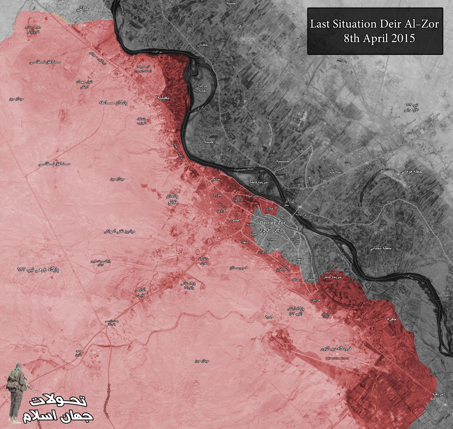
Add more villages in south-east Kobane canton?
Is it possible to add some more villages in the south-east of Kobane canton and north-west of Raqqah province? It would show the actual frontline more accurately, because there is "hole" on the map now.
I would suggest to use this map: https://twitter.com/MarkMonmonier/status/587511795180503040 It matches with the wikipedia map so far, although the villages spelling is different. So could someone please add JALABIYAH as held by YPG and SAB JIFAR as held by IS.
We will add new villages when there are reports about clashes inside them or that YPG/IS captured it. DuckZz ( talk) 09:51, 17 April 2015 (UTC)
Nab Al-Murr
SAA captured Nab Al-Murr 1 year ago during the kesab counteroffensive. http://www.al-monitor.com/pulse/security/2014/03/syria-kasab-opposition-army-battles.html and still saa control the town , please fix it 92.44.119.74 ( talk) 18:26, 17 April 2015 (UTC)
read please , it clearly says saa recaptured the town http://en.wikipedia.org/wiki/2014_Latakia_offensive
Marks moving 1 pixel down
About 90% of the location dots and other marks appear to have moved 1 pixel down. This might not seem important, but it makes updating the .png map a lot slower, because I rely on finding the difference between screenshots to make the maps, and there are about 150 marks to go through on this map, plus those on the Iraqi map. I was wondering if anyone knew what the cause might be. Banak ( talk) 17:02, 17 April 2015 (UTC)
I don't know exactly, but I am one of the main editors of the "War in Donbass Detailed Map", and I remember making an edit to the page outside of the map, and that moved all of the dots down very much.
http://en.wikipedia.org/wiki/Template:Donbass_War_detailed_map
You can look at the edit history of both to find a similarity. I hope this helps. 2601:0:B200:F7D9:D9DE:96EB:1551:6659 ( talk) 22:50, 17 April 2015 (UTC)
Updates in Kobane
Based on Chuck Pfarrer map1 & map2, Shash, Khan mamid, Jaban, Sal, Hamadun(&jayl), Qalat hadid and Nur Ali are with YPG. Mitras is with ISIS. Ricardomoha ( talk) 11:36, 14 April 2015 (UTC)
- We cant use pro Kurdish sources for displayed success of Kurds. Hanibal911 ( talk) 15:49, 14 April 2015 (UTC)
By this logic all western sources are pro-kurds, also SOHR can't be used as well.. Then only ISIS sources or Regime sources are accepted which makes no sense to me. Ricardomoha ( talk) 18:59, 14 April 2015 (UTC)
https://pbs.twimg.com/media/CC5zFsyVIAAtf33.jpg:large Latest map. Basically status quo ante plus from last year. Tgoll774 ( talk) 01:40, 19 April 2015 (UTC)
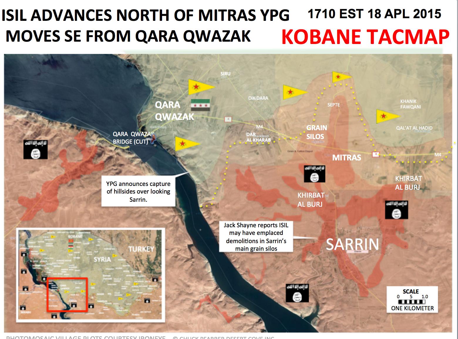
Khanasser
http://www.almasdarnews.com/article/main-government-supply-line-to-aleppo-cleared-syrian-army-captures-al-rashadiyah/ states that Al-Rashadiyah close to the Khanasser highway is taken by SAA. Where is this village? Paolowalter ( talk) 12:10, 15 April 2015 (UTC)
-
Paolowalter Here village of Al-Rashadiyah
here But need confirmation this data from neutral source becasue Al Masdar it is pro government source and we cant use him for displayed success of Syrian troops.
Hanibal911 (
talk)
12:30, 15 April 2015 (UTC)
- SOHR reported about clashes in Rashadiyah in Khanasser area near the southern countryside of Aleppo. SOHR Hanibal911 ( talk) 13:35, 15 April 2015 (UTC)
https://en.wikipedia.org/?title=Talk:Cities_and_towns_during_the_Syrian_Civil_War&action=edit§ion=12 Can someone confirm this and check on FSA claims to have also cut SAA supply routes to Aleppo. A lot of twitter posts about Rebels and IS advances south of Aleppo and cutting the road overnight. Tgoll774 ( talk) 13:53, 19 April 2015 (UTC)
- Tgoll774 There conversely army captured some area near the road and are repelled several attacks of ISIS on this road. Hanibal911 ( talk) 14:57, 19 April 2015 (UTC)
So basically a propaganda war, like with Baiji and others. But from the video its clear some level of combat is going on in the area from FSA and IS. FSA feeds claim IS hold Khanasser, SAA denies, FSA ah screw it. I say lock all edits for a week till we get better info, because it appears we hit a new mobile phase where settlements change hands every day. Tgoll774 ( talk) 15:45, 19 April 2015 (UTC)
Latakia
Have the rebel forces advanced in Latakia ? many more villages added and some taken from the SAA ? I have not read of any resent advance ,can someone kindly explain the situation . 86.178.97.43 ( talk) 18:38, 14 April 2015 (UTC)
SAA is in or near Rabia ... If u change towns, only with Sources please. To much anti-governments editors
WTF is that for nonsense? He/She who changed all those towns to green in Latakia better change it back to red or post some decent sources here. SyAAF ( talk) 21:14, 14 April 2015 (UTC)
The area has been changed several times due to different reports. Pro-opposition maps are showing always the same, and editors are changing this region according to them when a pro-gov or neutral source poops ops with a statement which might confirm that. And SOHR and some other sources were reporting that rebels atacked gov positions with GRAD rockets here and there near Latakia city, which might be logical because they are this close, and the range is limited. DuckZz ( talk) 08:34, 15 April 2015 (UTC)
No Reliable Source is backing those changes actually? Are you saying that? Mr.User200 ( talk) 13:17, 15 April 2015 (UTC)
The editor who made these changes needs to explain why they were changed or they should be reverted as its not one village but a big area . 86.178.97.43 ( talk) 13:44, 15 April 2015 (UTC)
I have no idea, because i did not change it. But the user posted a pro-government source and a pro-opposition map which both match up, so i guess it's ok as we often use pro-opposition sources combined with government maps to make edits in favor for the government. DuckZz ( talk) 10:25, 16 April 2015 (UTC)
Why aren't these changes changed back to the original? Sources are lacking, which means the they need to be changed back. MesmerMe ( talk) 20:21, 19 April 2015 (UTC)
YPG east of Sarrin
YPG has taken control over several villages and hills east of Sarrin, among them are known several villages whose names begin with Qirat, and a village which in Kurdish is called Serekaniye. http://www.4.hathalyoum.net/580799-%D8%A7%D9%84%D9%82%D9%88%D8%A7%D8%AA-%D8%A7%D9%84%D9%83%D8%B1%D8%AF%D9%8A%D8%A9-%D8%AA%D8%B3%D9%8A%D8%B7%D8%B1-%D8%B9%D9%84%D9%89-4-%D9%82%D8%B1%D9%89-%D9%88%D8%AA%D9%84%D8%A7%D9%84-%D8%A7%D8%B3%D8%AA%D8%B1%D8%A7%D8%AA%D9%8A%D8%AC%D9%8A%D8%A9-%D8%A8%D9%85%D8%AD%D9%8A%D8%B7.html
http://www.syrianewsapp.com/1/Article/2114/83262104#.VTQTAiGqqko
http://www.alahednews.com.lb/fastnews/267296/%D8%A7%D9%84%D9%88%D8%AD%D8%AF%D8%A7%D8%AA-%D8%A7%D9%84%D9%83%D8%B1%D8%AF%D9%8A%D8%A9-%D8%AA%D8%B3%D9%8A%D8%B7%D8%B1-%D8%B9%D9%84%D9%89-%D8%B9%D8%AF%D8%A9-%D9%82%D8%B1%D9%89-%D9%81%D9%8A-%D8%A7%D9%84%D8%AC%D8%A8%D9%87%D8%A9-%D8%A7%D9%84%D8%AC%D9%86%D9%88%D8%A8%D9%8A%D8%A9-%D8%A7%D9%84%D8%B4%D8%B1%D9%82%D9%8A%D8%A9-%D9%84%D9%83%D9%88%D8%A8%D8%A7%D9%86%D9%8A#.VTQTECGqqko Roboskiye ( talk) 20:54, 19 April 2015 (UTC)
This source says Qirat and Mitras villages were captured. But we should wait for SOHR or other twitter sources DuckZz ( talk) 21:28, 19 April 2015 (UTC)
Rebel presence in the mountains near Bureij and Hisyah
I think we should add a rural presence to signal the presence of rebels in the mountain range. A very interesting article by the neutral Al Safir newspaper (frequently quoted by AL Monitor due to its neutrality) that was shared by the pro-gov facebook page shows what rebels control in AL Qalamoun [4]: 3000 rebels controlling 1000km2 of territory including: Tal'at Moussa (aka Moussa MT) - Barouh Mount etc. (dozens of mounts and areas) but most importantly, they control the mountains near Bureij and Jawsiah and Qara. I already said that we cannot add all those mountain peaks but we could resume that by adding rebel rural presence in the space between Qara and Jawsiah crossing. Oh and I suggest removing those 2 mounts near Flita, there are dozens of those and they clutter the map. ChrissCh94 ( talk) 21:52, 19 April 2015 (UTC)
-
ChrissCh94 Done I add mark which showed rebels presence to west from Qara and Bureij between the town of Qara and Jawsiah.
Hanibal911 (
talk)
06:53, 20 April 2015 (UTC)
Use of Pro-gov sources to change rebel towns to Nusra
I have noticed that pro-government source PetoLucem https://twitter.com/petolucem often uses Al-Nusra flags in rebel-held territories to imply his viewers that Al-Nusra is in control of those towns.
https://pbs.twimg.com/media/CC-RSZTVAAEzuEN.jpg:large
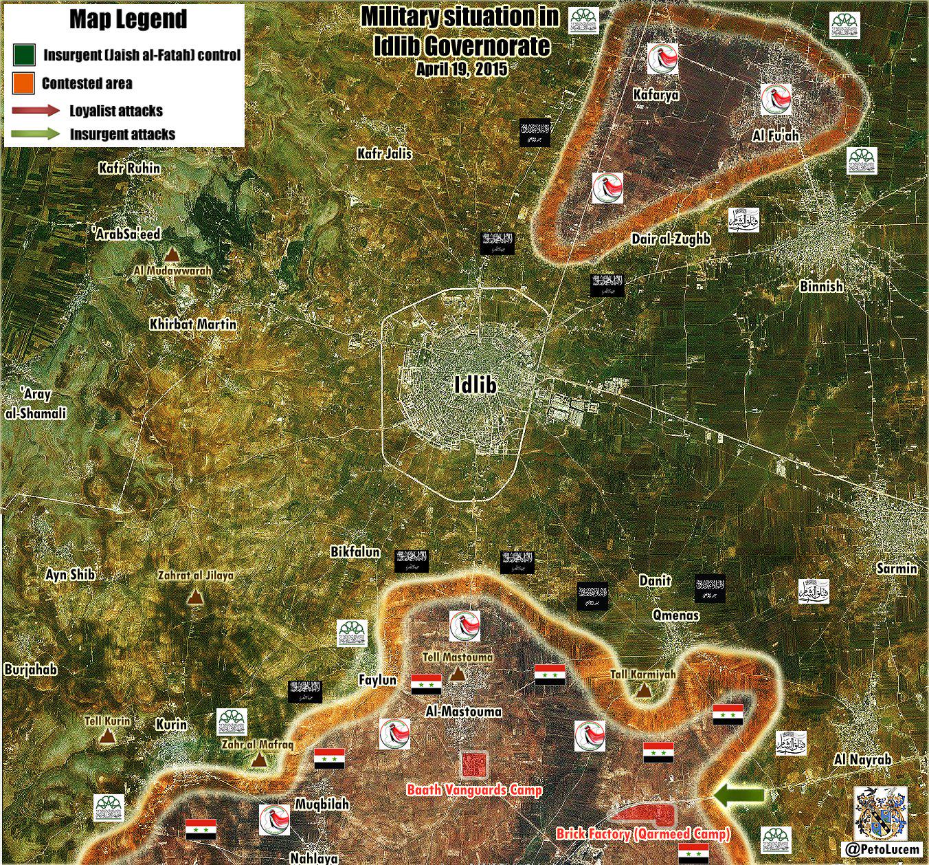
https://pbs.twimg.com/media/CCyrc8nWEAATHdm.jpg:large
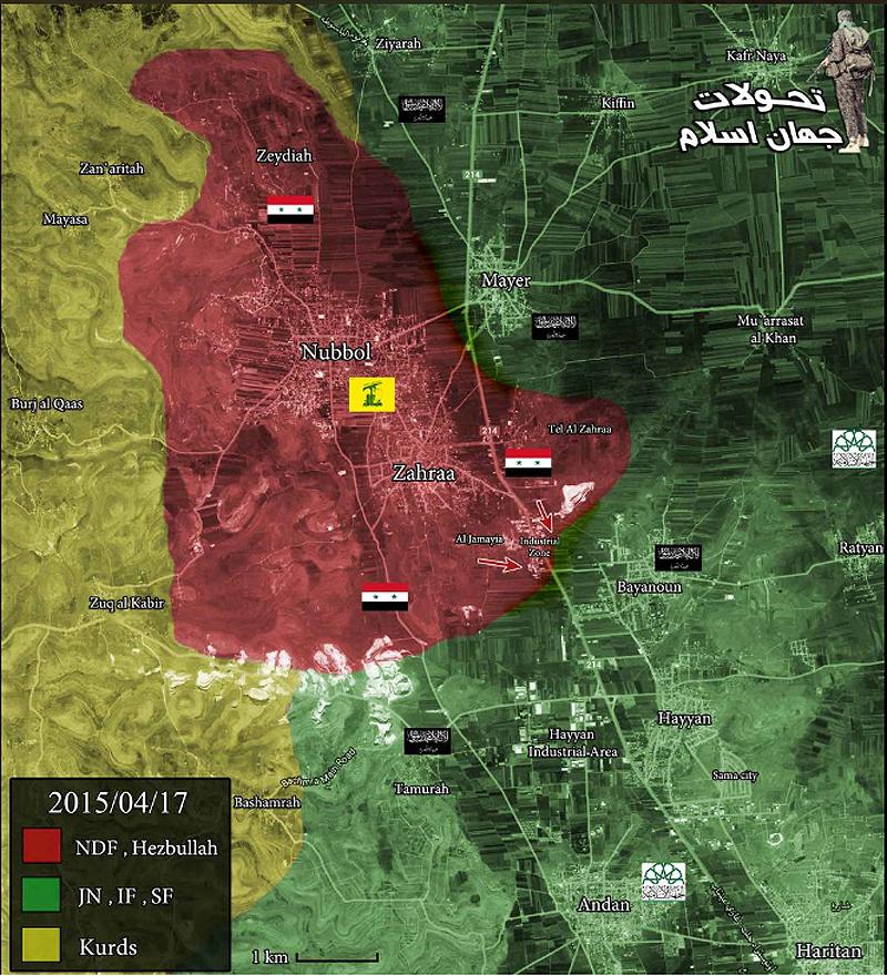
I think that we should not use this pro-govermnet source to edit rebel towns to Al-Nusra control, as this is an attempt by PetoLucem to brand most of the rebels as extreme jihadists who are part of al-Qaeda, to make people turn to his side. Secondly, him putting black Nusra flags does not necessarily mean that towns under these flags are under direct al-Nusra control; it simply is showing that al-Nusra forces are present on those front lines fighting. I think that if we keep doing this, eventually all of the green towns will be turned to grey simply because petolucem has black flags on his map. I also do not think he qualifies as a reliable source to prove al-Nusra control. Let me also say that I am not pro-rebel, pro-government, or pro-Nusra. I just think these towns should not be turned to grey because PetoLucem says they should. 2601:0:B200:F7D9:1547:CFD2:5C0E:E250 ( talk) 19:20, 19 April 2015 (UTC)
- The map you show is of Idlib. Al-Nusra has a dominant presence there, that is why all the flags are black. This is confirmed by multiple sources. If you look here at this Daraa map: https://twitter.com/PetoLucem/status/571759910653992960 you will see that there are in fact FSA flags plus nusra flags on it. I do not think he deliberately attempts to brand the rebels as Al-Qaeda. Problem is, rebels cooperate frequently with them, making it hard to determine who controls what. Still, I agree that we should use neutral sources for such changes. XJ-0461 v2 ( talk) 19:41, 19 April 2015 (UTC)
Petolucem said on twitter more than once that he belives Al Nusra controls 80% of rebel towns, which is crazy but he knows what kind of news his followers want to see. He is not an extreme pro-regime reporter like Leith Fadel for example but he understands that 80% of his readers are pro-government oriented, and they want that "Syrian army vs Al Qaeda" scenario, that's the reason they hate other rebel groups, mostly because the world needs no reason to hate ISIS or Al Nusra, but every other group seems to have some kind of a "OK" reputation. DuckZz ( talk) 20:18, 19 April 2015 (UTC)
- DuckZz If you believe that I was wrong when using these maps when would I noted the villages which is under the control of Al Nusra I revert those my actions or I can mark these villages as under jointly control rebels/Al Nusra. Hanibal911 ( talk) 20:26, 19 April 2015 (UTC)
Hanibal911 I can't revert it, because of, do it yourself. DuckZz ( talk) 20:43, 19 April 2015 (UTC)
- DuckZz I again mark villages of Mayer and Bayanoon as under control by rebels and Rityan as under jointly control as it was earlier but I mark as under jointly control the village of Tannurah which is I add according to data from pro government source and Ziyarah which is I edit from under Kurdish control to under jointly control FSA/JAN. So that the villages of Ziyarah and Tannurah will be marked as under jointly control before we not find to more data. Hanibal911 ( talk) 20:57, 19 April 2015 (UTC)
You can't use government sources for those changes, revert it, and use kurdish sources if you think something may need to be changed, but everything else should be reverted. DuckZz ( talk) 21:03, 19 April 2015 (UTC)
- DuckZz You can point me that I need fix and and I will do it because just so it will be easier for me. Hanibal911 ( talk) 08:08, 20 April 2015 (UTC)
Idlib
There are many mentions that SAA controlled Najd Kafr and Nahlaya. E.g. http://www.almasdarnews.com/article/syrian-army-makes-fresh-gains-in-idlib-kafr-najd-under-fire-control/ from yesterday evening reports Najd Kafr almost taken. Teh same source states that Qameenas is contested. On the map Najd Kafr is already red, while Nahlaya is contested and Qameenas green. Any neutral source not on twitter reporting this changes? Paolowalter ( talk) 12:03, 15 April 2015 (UTC)
- SOHR also confirmed that Syrian troops recatured village of Kafr Najd. SOHR Hanibal911 ( talk) 13:32, 15 April 2015 (UTC)
- 1) They are both considered controlled by the gov at the moment anyway. 2) They may have already retreated
https://twitter.com/arabthomness/status/588327180830171136 At the very least Kafr Najd should be changed to contested
- SOHR confirmed that the village of Kafr Najd under control of Syrian troops so we cant mark this village as contested on based data from biased pro opposition source. Hanibal911 ( talk) 13:52, 15 April 2015 (UTC)
- Pro opposition source said that the Syrian troops gained control over the villages of Kafer Najed and Nahelya in Idlib southern countryside after severe clashes with Islamic battalions. Document.Sy Hanibal911 ( talk) 14:06, 15 April 2015 (UTC)
- 1) They are both considered controlled by the gov at the moment anyway. 2) They may have already retreated
https://twitter.com/arabthomness/status/588327180830171136 At the very least Kafr Najd should be changed to contested
Acc. pro opposition source: Syrian Army imposes firearms-control over al-Muqblah town in Idlib countryside, after restoring Kafer Najed and Nahlaia today morning. Documents.sy 83.30.58.17 ( talk) 18:33, 15 April 2015 (UTC)
- This same source said: As clashes continue with fighters of al-Fateh Army around Feeloun and Qoureen villages in the southern countryside. Faylun - besieged on the south and east?
83.30.58.17 (
talk)
18:38, 15 April 2015 (UTC)
- Acc pro gov source
ivansidorenko1 and pro rebel
TheQalamon about Kurin - is also under control of SAA / fighting in city
83.30.58.17 (
talk)
19:35, 15 April 2015 (UTC)
- Pro opposition source also reported that Syrian troops also captured the town of al-Muqblah and that clashes continue with fighters of al-Fateh Army around Feeloun and Qoureen in the southern countryside.
Documents.sy
Hanibal911 (
talk)
20:44, 15 April 2015 (UTC)
- Another one pro opposition source reported that hevy clashes in the village of Kurin and Syrian troops are trying to take over Kurin.
Syrian Rebellion Observatory
Hanibal911 (
talk)
09:09, 16 April 2015 (UTC)
- Another source confirmed that Syrian troops captured three villages of Kafr Najd, Nahlaya and Muqbileh. World Bulletin Hanibal911 ( talk) 19:23, 17 April 2015 (UTC)
- Another one pro opposition source reported that hevy clashes in the village of Kurin and Syrian troops are trying to take over Kurin.
Syrian Rebellion Observatory
Hanibal911 (
talk)
09:09, 16 April 2015 (UTC)
- Pro opposition source also reported that Syrian troops also captured the town of al-Muqblah and that clashes continue with fighters of al-Fateh Army around Feeloun and Qoureen in the southern countryside.
Documents.sy
Hanibal911 (
talk)
20:44, 15 April 2015 (UTC)
- Acc pro gov source
ivansidorenko1 and pro rebel
TheQalamon about Kurin - is also under control of SAA / fighting in city
83.30.58.17 (
talk)
19:35, 15 April 2015 (UTC)
- Pro opposition source reported that rebels have withdrawn from the town Kurin because of lack of support from main HQ. Latif MfitaL Hanibal911 ( talk) 07:10, 21 April 2015 (UTC)
ISIS Capture Aadah Mount
ISIS Capture Aadah Mount and Several Important Points in Palmyra Desert.
http://syrian-mirror.net/en/cat/syria-mirror/isis-capture-aadah-mount-and-several-important-points-in-palmyra-desert/ ( Jack6780 ( talk) 23:59, 20 April 2015 (UTC))
- Firstly It is just data from the antigovernment source and secondly he just said that ISIS captured mount of Aadah near Alyaniyah area in Palmyra desert, after fierce clashes against opposition forces. Hanibal911 ( talk) 07:29, 21 April 2015 (UTC)
Nabe' El Murr - Latakia
Here is my point of view on how Nabe' El Murr is regime held:
- 1- Nabe'El Murr overlooks Kessab thus allowing fire control over the village and the crossing.
- 2- Rebel sources mentioning regime advances FROM Nabe' EL Murr towards Jabal Zahya where the SAA has captured Tall Snan and Tallat Wasat. [5] [6] [7] This advance was not possible if the regime did not control Nabe' EL Murr.
- 3- Rebel sources saying they shelled regime positions in Nabe' EL Murr [8] [9] [10]
- 4- Regime forces do control Mount AL Nisr, and this directly and easily overlooks the whole area and easily controls Nabe' El Murr. If the rebels were inside the village they are sitting ducks.
- The only thing contradicting me is the Al-Masdar article that said Nabe' EL Murr is rebel-held. Your thoughts? ChrissCh94 ( talk) 21:31, 19 April 2015 (UTC)
I belive we should change it to contested. Pro-opposition sources said that they are trying to advance towards Kessab, and this means Nabe El Murr is not rebel held but contested as Al Masdar has noted. DuckZz ( talk) 21:39, 19 April 2015 (UTC)
- ChrissCh94 DuckZz Pro opposition sources reported that they not control Nabe' El Murr and we need mark him as under control by Syrian troops. Source Al Masdar make many mistakes he said that rebels start offensive near Kessab but pro opposition source Cédric Labrousse said that this was just a small campaign near Kessab and Tower 45 created in fact with one goal : divide the regime forces advancing at dlib southern coutryside. Syrian Rebellion Observatory Syrian Rebellion Observatory So that it was just a small attack for that would distract the Syrian army from their offensive on the city of Idlib. SOHR also just said that about clashes between regime Syrian troops and their allied against rebels and the Islamic militant from another party, near the Observatory 45. SOHR Also another the pro opposition source reported that only Al Masdar reported that the rebel attacked Syrian troops in the area the border crossing. And that rebel channels have not released news about the attack. EA WorldView So maybe the Chief editor of Al Masdar was wrong when he said that Nabi al Murr under control by rebels. Also another pro government source showed that Nabi al Murr under control by Syrian troops. here So we have data from the pro opposition sources from SOHR and from pro government source that Nabi al Murr under control by Syrian troops but rebels located to east from him. So we need marked him as under control by Syrian troops. But we marked him as under rebels control only on base the data from pro opposition source which is dated on the end of December 2014 and on the one report from Al Masdar. But many other sources said that he under control by troops and this wrong because data from pro opposition source too outdated and pro government source maybe was wrong because his data not support other pro government sources. And pro opposition source deSyracuse also showed that this town under control by troops. here but rebel positions located to east from him. Hanibal911 ( talk) 07:27, 20 April 2015 (UTC)
Some more info from http://www.almasdarnews.com/article/jabhat-al-nusra-attack-on-kassab-repelled/. Nabe' El Murr is back under SAA control, previously was contested. I'd say re dwith a green hal ring on the right. Paolowalter ( talk) 07:03, 20 April 2015 (UTC)
Turning Nabe' El Murr contested is unreasonable. It used to be red (see above) it was turned green on the basis of an Al Masdar report and Al Masdar shortly after remarked that the town is back to SAA control. Beside Al Masadr being reliable in general, Al Masdar is not announcing a SAA advance but a short lived rebel advance, followed by restoration of the previous status quo. Therefore Nabe' El Murr back to red as it used to be. Paolowalter ( talk) 11:48, 21 April 2015 (UTC)
Mseikeh & NE Daraa
It seems that the SAA 5th has launched an attack on NE Daraa and has captured 5 villages. Mseikeh is the only one that is in the map and should be changed to Government held. Sources are pro-opp and pro-gov.
According to document sy. SAA captured Miskya al-Sharqia and al-Gharbiya, al-Khwabe, Ishnan, al-Dallafa https://www.facebook.com/documents.sy/posts/929032690492821 Miskiyah location: http://wikimapia.org/#lang=tr&lat=32.911874&lon=36.341915&z=14&m=b Hwinsp ( talk) 11:26, 20 April 2015 (UTC)
- Biased a pro opposition source also reported that the Regime troops launched new offensive on the town of Busra al-Harir. Archicivilians Hanibal911 ( talk) 11:32, 20 April 2015 (UTC)
- I didn't mention the other villages captured since I had a very hard time finding any of them. Anybody had any luck? MesmerMe ( talk) 11:41, 20 April 2015 (UTC)
other villages probably here: http://wikimapia.org/#lang=tr&lat=32.871586&lon=36.331959&z=13&m=b&gz=0;363000297;328518313;581073;281162;350189;305669;0;89404;263500;0;538158;78590;568199;271070 Hwinsp ( talk) 11:45, 20 April 2015 (UTC)
- Would it be smart to include one of the village to indicate that Busra al-Harir is surrounded (
http://wikimapia.org/#lang=en&lat=32.877857&lon=36.338654&z=12&m=b&show=/31775463/Village)? To include all of them isn't necessary since they're likely very small.
MesmerMe (
talk)
11:55, 20 April 2015 (UTC)
- Pro government source reported that Syrian troops captured villages East Maseekat, West Maseekat, Rassum Al-Khawaabi, Ishnaan, and Al-Dalasat in northeast Dara. Al Masdar Hanibal911 ( talk) 12:18, 20 April 2015 (UTC)
Pro Rebel source https://twitter.com/Syria_Rebel_Obs/status/590141059986026496 says that the SAA is attacking Nahtah from the East. There should be a red circle on the right side of the town. MesmerMe ( talk) 13:45, 20 April 2015 (UTC)
- SOHR also confirmed that the Syrian troops cut all supply line of rebels between the town of Busra al Harir and other rebel positions in the Lajat after captured villages near Busra al Harir.
SOHR
Hanibal911 (
talk)
14:07, 20 April 2015 (UTC)
- Maybe we need add red semicircles near villages which is under control by rebels in Lajat becasue the pro opposition source and SOHR clear said that Syrian troops cut all rebel supply lines in Lajat and that now rebels in this area under siege becasue they in blockaded after all their supply lines with another territory under control by rebels.
SOHR
Syrian Rebellion Observatory
Syrian Rebellion Observatory For now we have situation is the same as well as to the north of the city of Homs where the some towns and villages are under the control of the rebels but cut off from supply lines.
Hanibal911 (
talk)
14:29, 20 April 2015 (UTC)
- I agree. These towns are currently fully surrounded much in the same nature as Northern Homs.
MesmerMe (
talk)
14:37, 20 April 2015 (UTC)
- These two to almost identical situations. Also so we have noted previously some villages which is was under the control of the army in the Idlib province near the town Maarat Numan and military bases (Wadi Daif and Hamidiyah) before they were captured. Those villages were also cut off from the supply lines.
Hanibal911 (
talk)
15:16, 20 April 2015 (UTC)
- Also my actions confirmed the pro opposition source. Syrian Rebellion Observatory He also reported that the Regime take over the supply lines and villages between Lajat area and Busra al Harir. Hanibal911 ( talk) 17:40, 20 April 2015 (UTC)
- These two to almost identical situations. Also so we have noted previously some villages which is was under the control of the army in the Idlib province near the town Maarat Numan and military bases (Wadi Daif and Hamidiyah) before they were captured. Those villages were also cut off from the supply lines.
Hanibal911 (
talk)
15:16, 20 April 2015 (UTC)
- I agree. These towns are currently fully surrounded much in the same nature as Northern Homs.
MesmerMe (
talk)
14:37, 20 April 2015 (UTC)
- Maybe we need add red semicircles near villages which is under control by rebels in Lajat becasue the pro opposition source and SOHR clear said that Syrian troops cut all rebel supply lines in Lajat and that now rebels in this area under siege becasue they in blockaded after all their supply lines with another territory under control by rebels.
SOHR
Syrian Rebellion Observatory
Syrian Rebellion Observatory For now we have situation is the same as well as to the north of the city of Homs where the some towns and villages are under the control of the rebels but cut off from supply lines.
Hanibal911 (
talk)
14:29, 20 April 2015 (UTC)
WHy have all changes been reverted? The only reports that are available say that they've retreated from Busra al-Harir, not from the villages they've already caputured. MesmerMe ( talk) 16:14, 21 April 2015 (UTC)
SOHR reported only retreat from Busra al-Harir not from any other village. The video used to support the revert is in arab and I can't understand it. In any case it is a pro-opp outlet and cannot be used to support rebel advance. Please go revert. Paolowalter ( talk) 16:38, 21 April 2015 (UTC)
There were changes based on Agathocle map but then they were self reverted. Why? Paolowalter ( talk) 16:38, 21 April 2015 (UTC)
- Agothocle's also shows an extremely different situation in Latakia, but we cannot use him as a source. come on, this is old news!! MesmerMe ( talk) 18:15, 21 April 2015 (UTC)
Pro opposition source said, that rebels recapture all village, but it is only pro opposition source, acording pro regime source SAA enter Busra al-Harir. I am looking source to changes all the villages on the green. 83.30.58.250 ( talk) 18:24, 21 April 2015 (UTC)
The villages need reverting unless reliable sources can be shown . 86.178.97.69 ( talk) 19:05, 21 April 2015 (UTC)
Regime offensive in Busr Al Harir
Why did we not show the SAA gains? ChrissCh94 ( talk) 19:08, 21 April 2015 (UTC)
I restored the situation before the removal of the gain of SAA in this area. Paolowalter ( talk) 19:27, 21 April 2015 (UTC)
The pro-opposition source http://syriadirect.org/news/syria-direct-news-update-4-21-15/ states today that the offensive was repelled at Busr Al Harir but reports the yesterday advance of SAA without any mention that those gain have been reverted. Paolowalter ( talk) 19:45, 21 April 2015 (UTC)
- This is common, I call it the rebel "shrinking pains". Even time there is a successful regime offensive, they will have claimed to have revered completely within 24 hours[As well as have killed "thousands" of regime soldiers]. So far, the most reliable source we have is a sky-news [pro-opp] video present by SOHR [pro-opp]. The best thing to do is wait for confirmation from a reliable source or wait until one side implicitly or explicitly concedes defeat. XJ-0461 v2 ( talk) 20:38, 21 April 2015 (UTC)
Who changed them to green? > 86.178.97.69 ( talk) 20:47, 21 April 2015 (UTC)
- We saw it in Aleppo (Handarat Pashqoi), in the Daraa-Quneitra-RifDimashq area (Deir el Adas etc.) and in Latakia (Durin) to name a few. SOHR and rebel sources claimed to repulse the offensive and denied the advances but we all saw later on that the regime did gain ground. Not saying regime sources are always spot on and reliable. On the contrary, this is war and propaganda is present in all sides. But at least SANA mentions retreats/defeats by saying that troops "REPOSITIONED" themselves (cf. Tabqa, Nawa, Idlib).
ChrissCh94 (
talk)
21:30, 21 April 2015 (UTC)
- the pro-regime crowd is not backing down from their claims of current control. Al-Manar video from 2h ago [supposedly] : https://twitter.com/IvanSidorenko1/status/590625283163738112 XJ-0461 v2 ( talk) 23:51, 21 April 2015 (UTC)
Balancing the map
I think the template is a bit imbalanced. For example, there are a lot of blank areas and then suddenly a clutter of villages/farms. This makes viewers and readers think that the blank spaces correspond to an empty desert area which is not the case. So what I suggest is the following:
- Reduce the number of villages that clutter far from a frontline such as: the Kurdish and regime held areas south of Qamishli, just keep the ones on the outside so we could know the limits of control but reduce the ones in the center a bit. If we know who controls the outline we don't have to fill the center. Another suggestion is the ISIS-held area in Eastern Homs. Remove some villages/farms from the center of the area without changing the frontline. There is also the Latakia villages near Durin, just keep the ones separating rebel from regime held areas.
- I also suggest adding some towns/villages in south-west Aleppo between the Khanasser Safira road and Abou l Douhour airbase and south of AL Hadir. It is empty while in fact it is mostly rebel-held thus tricking people into thinking that Abu l Duhur can be reached by regime forces.
Your thoughts fellow editors? ChrissCh94 ( talk) 18:03, 20 April 2015 (UTC)
- Let's leave it at that. If we start to just removed or add on map the villages or cities we can provoke negative consequences because some new editors and are not quite disciplined editors can harm the map. We must not without reason, add or delete villages and towns. Let's leave it at that. Dont need to provoke actions that ultimately can harm for map. So that as I said on the map can begin series of unjustified changes. So I'm against it. Hanibal911 ( talk) 19:28, 20 April 2015 (UTC)
- I agree with ChrissCh94 — Preceding unsigned comment added by 137.73.84.13 ( talk) 11:02, 22 April 2015 (UTC)
- Why can't we make some of these dots smaller on the map? Then we could still know their locations if and when the front lines change, and they wouldn't be as noticeable. I think that this is a good compromise between these 2 views. 2601:0:B200:F7D9:C819:4EE0:A8BF:ABB3 ( talk) 22:52, 20 April 2015 (UTC)
- I know this might sound crazy, but can we turn the map to become more interactive (I mean zoom-able by interactive), if not for all parts of the map, at least for some parts like Idlib and Khabour. I'm not an expert in wikipedia programming, but I simplify the logic to this: if someone puts cursor over south of Idib it zooms in or shows a more clear map. The more clear map might be just normal zooming or another map that we add over. Ricardomoha ( talk) 16:04, 21 April 2015 (UTC)
- I don't think that's possible. It would be very difficult to implement, and would make the map even more confusing. 2601:0:B200:F7D9:D4D5:B002:E9CF:1AB1 ( talk) 01:05, 22 April 2015 (UTC)
Tal Barak updates
According to this Map, which is from a pro-kurd source, Kakah said is with ISIS, also update the hasakah map with SAA advance. Ricardomoha ( talk) 19:12, 17 April 2015 (UTC)
- Why am I getting this feeling that this and many others are just WP:CIRC? EllsworthSK ( talk) 10:28, 18 April 2015 (UTC)
- Give me a proof not feelings. Ricardomoha ( talk) 18:26, 18 April 2015 (UTC)
- Are we using maps? I thought we were trying to abandon using them unless they provided sources to avoid WP:CIRC? Banak ( talk) 20:44, 18 April 2015 (UTC)
- That doesn't make sense, because his original map had Kaka said under SAA control on 4/4/2015 and now it's under ISIS control on 18/5/2015, we can take his word because he's a pro-kurdish source. Simple as that. If your point is that this map was maybe taken from old Wiki maps his original map denies that. Ricardomoha ( talk) 13:09, 19 April 2015 (UTC)
http://www.agathocledesyracuse.com/wp-content/uploads/2015/03/Khabour-valley-21-April-2015-by-@deSyracuse.png and http://umap.openstreetmap.fr/fr/map/desyracuse-syria-civil-war-21-april-2015_37133#12/36.4826/40.7586 Latest Agacothles de Syracuse Maps. Looks like Tal Barak is under IS administration or contested, but it says control when I click. Tgoll774 ( talk) 19:09, 21 April 2015 (UTC)
http://umap.openstreetmap.fr/en/map/twittercetin609-tap-the-map-for-information_36481#15/36.6413/41.0750 Pro-Kurd map for comparing with other map sources. Tgoll774 ( talk) 14:45, 22 April 2015 (UTC)
Latakia
Agathocle map http://umap.openstreetmap.fr/fr/map/desyracuse-syria-civil-war-21-april-2015_37133#11/35.7543/36.0530 confirms our old front line. That was changed only on the basis of Al mansar report http://www.almasdarnews.com/article/syrian-army-on-the-move-in-northern-latakia-turkish-border-crossing-within-distance/ (never confirmed by other sources) that later was made obsolete by http://www.almasdarnews.com/article/jabhat-al-nusra-attack-on-kassab-repelled. Therefore all the area west of Kabir must go red.
Agathocle himself said that he was offline for 2 months and made the map according to frontline news. And he is somehow neutral, while Leith Fadel is extreme pro-government orinanted. Also we have other pro-oposition sources confirming Al Masdar reports. DuckZz ( talk) 20:08, 21 April 2015 (UTC) DuckZz ( talk) 20:07, 21 April 2015 (UTC)
We already marked Nab Al Mur back to red. Step by step, no need to rush and change everything. DuckZz ( talk) 20:57, 21 April 2015 (UTC)
- @deSyracuse not neutral source most of changes on this map
here he made on based the data from the pro opposition sources(including pro opp. maps) and also some time he coopirated with another pro opposition source (archicivilins) and we have discussed this many times and has been proven that it's pro opposition source. So that this guy not a neutral source. Also earlier we agreed not use this map to displayed succes of all antigoveenment groups(including ISIS) so dont need break the previously agreed rules.
Hanibal911 (
talk)
21:15, 21 April 2015 (UTC)
- Partialy I agree with
DuckZz no need to rush and again, mark all the villages as under control of army but also I still think we were wrong when we on based on the outdated pro opposition map and comments from pro-government activist pointed out so many villages under rebel control because other pro government sources showed a completely different situation.
Hanibal911 (
talk)
21:25, 21 April 2015 (UTC)
- Let's just keep it as it is for the moment as a sort of compromise. If we encounter some new sources then we'll bring up the subject again. ChrissCh94 ( talk) 21:32, 21 April 2015 (UTC)
- Partialy I agree with
DuckZz no need to rush and again, mark all the villages as under control of army but also I still think we were wrong when we on based on the outdated pro opposition map and comments from pro-government activist pointed out so many villages under rebel control because other pro government sources showed a completely different situation.
Hanibal911 (
talk)
21:25, 21 April 2015 (UTC)
Agothocle has admitted that he used the wikipedia map as his source,so there is alot of doubt on it,archicivilians map best describes the situation,which leith confirmed. Alhanuty ( talk) 23:01, 21 April 2015 (UTC)
Strongly pro-opp map here https://twitter.com/Conflict_Report/status/590608725985067008 clearly show that the locations between Qastal Maaf and Rabia are under SAA control. These positions includes Ateera and Al-Sooda that must go back to red. Paolowalter ( talk) 08:34, 22 April 2015 (UTC)
- Done
Hanibal911 (
talk)
15:04, 22 April 2015 (UTC)
Semi-protected edit request on 22 April 2015
This
edit request to
Module:Syrian Civil War detailed map has been answered. Set the |answered= or |ans= parameter to no to reactivate your request. |
change
{ lat = "33.104", long = "36.739", mark = "Location dot red.svg", marksize = "6", label = " al-Asfar", link = "#no", label_size = "0", position = "top" },
to
{ lat = "33.104", long = "36.739", mark = "Location dot black.svg", marksize = "6", label = " al-Asfar", link = "#al-Asfar", label_size = "0", position = "top" },
and
{ lat = "33.007", long = "36.739", mark = "80x80-red-black-anim.gif", marksize = "6", label = " al-Qasr", link = "#no", label_size = "0", position = "right" },
to
{ lat = "33.007", long = "36.739", mark = "Location dot black", marksize = "6", label = " al-Qasr", link = "#al-Qasr", label_size = "0", position = "right" },
source:
http://www.understandingwar.org/backgrounder/syria-situation-report-april-14-21-2015
2601:0:B200:F7D9:D4D5:B002:E9CF:1AB1 ( talk) 01:01, 22 April 2015 (UTC)
- How many times I must say you that this antigovernment source which we cant use for displayed success rebels and ISIS. This source support all who against Syrian troops and he called Syrian troops as regime forces or Assad troops and we not use against Syrian troops all source which call Syrian troops as regime force. The only exception was made for SOHR becasue his data used many reliable sources. Several days ago pro-ISIS source said that ISIS captured those villages and now this source just duplicated those data need confirmation from neutral sources or SOHR. Hanibal911 ( talk) 12:31, 22 April 2015 (UTC)
- I am sorry. I thought since ISW was anti-ISIS and a reliable source, it could be used show an ISIS advance. It seems to me unlikely that they would report this from some pro-ISIS media outlet without verifying it first. 2601:0:B200:F7D9:148:D945:1A4:80B3 ( talk) 19:58, 22 April 2015 (UTC)
IS cuts off key rebel supply route from Jordan to the Damascus countryside
http://syriadirect.org/news/is-cuts-off-key-rebel-supply-route-from-jordan-to-the-damascus-countryside/ I'll let the usual editors look it over to cross reference. Tgoll774 ( talk) 20:30, 22 April 2015 (UTC)
Supply lines to Lajat reopened
http://syriahr.com/en/2015/04/37-fighters-from-rebel-and-islamic-battalions-killed-during-clashes-in-dara/ — Preceding unsigned comment added by 137.73.84.13 ( talk) 01:49, 22 April 2015 (UTC) :SOHR does not say which towns were recaptured, only areas around Busr al-Harir. Also, since this is SOHR, I would wait for a neutral source. Although, I am surprised that the more rebels were killed. That really is something. XJ-0461 v2 ( talk) 02:48, 22 April 2015 (UTC)
This SOHR report does not say villages were taken by rebels and its in English which has proven to be unreliable so the villages should be marked red . 86.178.97.69 ( talk) 07:21, 22 April 2015 (UTC) As long as there is no mention of change of control of towns with names explicitly written or reliable map we must retain the Lajat map with SAA controlled towns. The usual vandal changed it, please could somebody revert this change (I would break the 1RR rule). Paolowalter ( talk) 07:43, 22 April 2015 (UTC)
SOHR is reliable,so shut up,it clearly mentioned that all areas taken by regime forces in the offensive have been recaptured by the rebel,which includes all towns,and Paolowalter,if you don't stop your personal attacks,i will be reporting you for your vandalizing behavior,understood. Alhanuty ( talk) 12:15, 22 April 2015 (UTC)
You fucking braindead, SOHR is the biggest casualty cheaters of all time. Their sources are "activists" who work for al nusra. LOL "reliable"
- Seriously, SOHR is not reliable. All changes should be reverted, since there is absolutely no evidence. These are vandal changes that are highly favourable to the rebels. 12:41, 22 April 2015 (UTC) MesmerMe ( talk)
Agree the editor who made these changes needs to be told how edits work and if they continue blocked . 86.178.97.140 ( talk) 16:14, 22 April 2015 (UTC)
SOHR has established itself as authentic source throughout the entire Syrian Civil War,it was decided so based on Major News Source,and it the conclusion was reached in 2012,way before alot of the new editors cam here. https://www.facebook.com/syriahro/videos/10153299975868115/. Alhanuty ( talk) 17:36, 22 April 2015 (UTC)
- Today is 2015 year and now we have many new, more reliable source than SOHR. Many time we discussed here about SOHR and their mistakes. You need to confirm this, SOHR is pro opposition. I don not see any proof to recapture this villages, only biased markito. Every time if SAA capture some ground, than next day rebels claims that they recapture all area without proof. Show evidence or obviously breaking the rules here established - using pro rebel source to show rebel advance. I do not see any one photo or video from these areas 83.30.54.5 ( talk) 18:40, 22 April 2015 (UTC)
Recently sohr English translation made major mistakes it was decided not to use it as a sole source editor Hanibal911 stated this and all others agreed — Preceding unsigned comment added by 86.178.97.140 ( talk) 18:53, 22 April 2015 (UTC)
Alhanuty SOHR never said rebels retake villages only regain ground around Busra harir read the report and stop making lies or we report you . 86.178.97.140 ( talk) 19:29, 22 April 2015 (UTC)
The Arabic SOHR report confirmed that regime forces lost all areas they captured since the start of the offensive,so stop making up things,SOHR is still reliable more reliable than the pro-regime sources you listen to. Alhanuty ( talk) 19:34, 22 April 2015 (UTC)
- Enough making up facts. A new consensus as been reached. One, SOHR English is not to be used and SOHR Arabic is to be used with a corroborating source. SOHR is to a reliable source to be used alone, not anymore. XJ-0461 v2 ( talk) 20:02, 22 April 2015 (UTC)
- Your only source is this video? For me, it is just as reliable SAA general which say that they capture 5 village. Since yesterday, there is no photo or video of these villages, but if rebel destroy some tank they upload video in 5 minutes. I find this map Islamic World News more reliable than SOHR 83.30.54.5 ( talk) 20:13, 22 April 2015 (UTC)
who are you to make up rules here,you people just made accounts like just months ago,and want to dictate,which source is to be used and which doesn't,plus,maybe editors with a pro-regime stance are with you,but alot of neutral editors aren't with these extreme opinions. Alhanuty ( talk) 22:13, 22 April 2015 (UTC) plus that is a pro-regime map. Alhanuty ( talk) 22:13, 22 April 2015 (UTC)
-
Alhanuty was right because SOHR clear said that Syrian troops retreated and rebels regain control of five villages which they lost earlier.
Hanibal911 (
talk)
22:34, 22 April 2015 (UTC)
- Alhaunty, You do understand that your "seniority" gives no NO extra say in matters right? Also, waiting for a neutral source to back SOHR is not an "extreme option" .[In an 8-5 vote, editors agreed to this, so no minority here]. Hanibal, could you please link the SOHR article where its says that. Last time, you linked a SOHR link that cited pro-opp sky-news. P.S. Al-Monitor confirms villages in SAA hands: http://www.al-monitor.com/pulse/security/2015/04/syria-daraa-rural-takfiri-terrorists-offensive-bisr-al-qasab.html [This article is about as current as the SOHR article claiming rebel recapture.] XJ-0461 v2 ( talk) 22:41, 22 April 2015 (UTC)
- I only saw that SOHR said regime forces retreated from the vicinity of Busr AL Harir. And rebel sources always claim they recaptured lost ground immediately. I find this funny because at this rate, they should have captured all of Syria by now and not less than a quarter of it.
ChrissCh94 (
talk)
10:39, 23 April 2015 (UTC)
- ChrissCh94 Ok if a reliable source Al Monitor confirmed that those villages still control by Syrian troops we must trust this data. Hanibal911 ( talk) 10:45, 23 April 2015 (UTC)
Once again SOHR is wrong how many more times must this happen before we all stop using it as a single source for edits .SOHR needs to be confirmed like other sources . 86.178.102.166 ( talk) 14:01, 23 April 2015 (UTC)
Map problem
Some of you may have noticed. The map has problems with updating recent edits. Just wanted to write this so that evevryone knows it's the same for every user. DuckZz ( talk) 08:16, 22 April 2015 (UTC)
- Oh good, my connection is not going bad. Is there anything that can be done to fix it though?
XJ-0461 v2 (
talk)
20:07, 22 April 2015 (UTC)
- DuckZz, XJ-0461 v2 has this been fixed? What was the problem? I can't see any problems at the moment, but want to be sure the map is accurate when I update the .png one from this one. Also I can't see what would have caused it, perhaps it was a module that this one depends on. Banak ( talk) 14:52, 23 April 2015 (UTC)
YPG/rebels offensive against ISIS in Sarrin
Pro opposition and pro Kurdish source reported that Kurdish troops(YPG) jointly with moderate rebels started major offensive against ISIS in area near the town of Sarrin that would capture the town. Syrian Rebellion Observatory Mark Monmonier and that YPG/rebels captured some villages and hill near this town and now trying cut the last supply line from the main of ISIS positions to north toward the town of Sarrin. Maybe someone have more data about this offensive. Hanibal911 ( talk) 17:23, 20 April 2015 (UTC)
According to SOHR YPG captured the three villages that surround Sarrin (no names specified), with the only supply route left being through the Euphrates river towards IS held areas west of it, indicating YPG control over areas south of the town:
http://www.syriahr.com/2015/04/مصرع-10-عناصر-على-الأقل-من-تنظيم-الدولة/
186.112.206.36 ( talk) 03:11, 22 April 2015 (UTC)
https://7496bff410df41fc380ad565a50f607d4b1e8372.googledrive.com/host/0BzN49CdHSAwmcGU4eEI5dVBGZXM/SarrinCity-2015-04-22.png Pro-YYPG source to compare with other sources. Tgoll774 ( talk) 15:38, 23 April 2015 (UTC)
| This is an archive of past discussions. Do not edit the contents of this page. If you wish to start a new discussion or revive an old one, please do so on the current talk page. |
| Archive 40 | ← | Archive 44 | Archive 45 | Archive 46 | Archive 47 | Archive 48 | → | Archive 50 |
Jabhat al Nusra
A lot of towns are listed under exclusive Nusra control, mostly by Hanibal911. The ones I have issue with the most are Saraqeb and Maarat al Nuuman, which are regional capitals for the rebels since 2012, sporting a large number of Islamist and FSA groups that did not participate in the SRF/Hazzm war with Nusra and were thus left alone. Maara was made into Nusra territory after SRF HQ's were seized (even though Suqur al Sham and Ahrar al Sham seized those HQ's along with Nusra). Saraqeb was made into Nusra territory based on this very vague statement Joshua Landis: ″Blin, Bluin, Bsqala, Binnish, and Saraqib are under the control of Jund Al-Aqsa, a group loyal to Ayman Al-Zwahiri.″ As there have been no reports of Jund al Aqsa expelling Suqur al Sham, Ahrar al Sham, or Jabhat Thuwwar Saraqeb here, an FSA participant in Jaysh al Fateh that dates back to 2012 in Saraqeb city, the statement is far too ambiguous to be used as a definitive marker of control. Additionally at least one pro-rebel source reports that al Farouq linked Jaysh al Sunna in Jaysh al Fateh has a component in Saraqeb called Liwa al Iman here In light of these findings, I pose two main questions:
- 1. Just because a source is not neutral, doesn't mean it's not reliable, especially when it comes to reporting on intra-rebel affairs, rather than rebels vis-a-vis the regime - or ISIS. In other words, the only sources on the ground that might have an idea who controls Saraqeb would all be considered by partisans as not neutral. WP:NEUTRALSOURCE is useful in this case.
- 2. Just because Jabhat al Nusra eliminates one or two groups, doesn't mean they control the whole city. The SRF and Hazzm are just two factions; counting the 5th Legion affiliated ones you have three at most. This doesn't mean every other faction magically ceases to exist. Before 2014, ISIS, Nusra and Ahrar co-ruled Raqqa, and under our current colour scheme the city would have been split into three colours. This came after ISIS expelled both the YPG and the FSA out of the city in major flare ups. That did not mean Raqqa went to exclusive ISIS control until Nusra and Ahrar were expelled definitively in January 2014. In that light, I question the viability of making large chunks of Idlib into Nusra exclusive dominions, when half the time Ahrar al Sham was by their side. For example, Ram Hamdan would be a good Islamic Front stronghold given that it hosted a secret meeting for Ahrar al Sham where its members were assassinated, but it's listed as being occupied by Nusra. I doubt Nusra would expel them from it, nor would it pour enough manpower to overpower them by a 7:3 ratio of control.
Ironically, while the map exaggerates Nusra control in Idlib, it ignores it in Aleppo. Since July, Nusra has increasingly arrested members of Liwa al Tawhid defectors and the FSA in Marea Alaan TV here Meanwhile, Nusra's dar al qada appears to be basing itself in Hreytan (where Jabhat Ansar al Din is also based), and extending its authority to Kafr Hamra and Anadan here. These towns should at least be shared between Nusra and rebels. However, I also doubt Darat Izza to be under Nusra control completely; Nusra and Hazzm in Darat Izza signed a neutrality pact to avoid the fighting that took place near Atareb, so Nusra never expelled Hazzm. here And Hazzm in Darat Izza then defected and joined Kataeb Mujahidee Ibn Taymiyya here, a defector from the Levant Front. This means Ibn Taymiyya's faction is stronger than ever in Darat Izza, and until we can find whether they're a proxy of Nusra or a truly independent group, the city should stay half green. Regiment 111 was also reportedly handed over to the Levant Front as part of the agreement between Hazzm and Nusra here. NightShadeAEB ( talk) 09:43, 1 April 2015 (UTC)
And i remember when somebody told me "DuckZ you are wrong, there won't be much problems adding a seperate joint color for Rebels". As it already is, the biggest problem here is the joint control. I understand that JAN needs a color ok, but why joint control ? It's just too complicated to find out which party controls which town and village together with other groups. I don't even know what to say but the joint control is a stupid idea in my opinion, because in almost every town/village there is both JAN and Rebel (IF/FSA....) presence, because they are working together, despite the clashes between some groups. Joint control doesn't make any sense in my opinion, it's either mostly JAN or mostly under Rebel control. Period ! DuckZz ( talk) 10:23, 1 April 2015 (UTC)
- NightShadeAEB Let's take that would not spend much time on discussions, you just can list the towns and villages that you think should be under full control of Al Nusra and which are under jointly control rebels/al Nusra. And we consider the situation with each of them but without much tedious discussions only facts(from reliable sources). But we can mark them (to under JAN or rebels or maybe under jointly control JAN/rebels) only on the basis data from the reliable and neutral sources. Hanibal911 ( talk) 10:42, 1 April 2015 (UTC)
- For Idlib, the ones I have issue with are first of all Saraqeb and Maarat al Nuuman. If we do not apply shared control, as DuckZz said, then they should both be fully green because the combined might of Ahrar al Sham merged with Suqur and any miscellaneous small groups dwarfs Nusra and Jund al Aqsa, for now. Maarat Misrin and Ram Hamdan, I'm not sure, what source did you use when you made them Nusra held, Hanibal911? Maarat Misrin certainly has strong Nusra presence but not sure if they're the strongest. Ram Hamdan, I haven't seen sources on Nusra there, but I see circumstantial evidence of Ahrar al Sham and Jaysh al Islam being dominant. Given how active Jaysh al Islam and Faylaq al Sham have been against Fua and Kafraya, they must be based either in Binnish, Ram Hamdan, or Maarat Misrin. As Binnish has been Nusra's capital since 2012, I'd guess they might be based in those other towns.
- Moving on to Aleppo, if we keep shared control, Darat Izza should be half green, but if we don't, then keeping it grey is fine. Same for Marea; either fully green or half grey. Marea makes it complicated for asserting dominance though, as it's the town where Nusra has been the most aggressive outside of Idlib, and yet it enjoys backing from Ahrar al Sham and factions within the Levant Front, so how to gauge this in terms of control is anyone's guess unless we agree to the joint control depiction. Also Hreytan, Kafr Hamra, and Anadan. Since Ansar al Din are allies with Nusra, but Ahrar al Sham and the Levant Front also boast a presence, I'd suggest making them all half grey in case we agree to joint control, or making them all completely grey in case of uniform colours. However those three towns are covered by the map; we'll need to add them as dots of control like we have with the checkpoints within the map presently. Oh, and also Regiment 111 near Darat Izza; Nusra withdrew and gave it to Levant Front as part of the deal with Hazzm, although they were accused of assaulting it again after the fighting was over. No news on whether Nusra retook it or not, if anyone has a source they're more than welcome to share.
NightShadeAEB (
talk)
17:36, 1 April 2015 (UTC)
-
NightShadeAEB I agree that maybe I was wrong in situation with the Maarat Misrin and Ram Hamdan when marked Maarat Misrin under jointly control Al Nusra and rebels and when marked Ram Hamdan under control al Nusra on based a map from pro government source but I also to based this map also marked some towns and villages under control by rebels and change status the town Rami from Al Nusra control of under control by rebels. But in situation with others towns and villages and also military base of Regiment 111 you just provide data from the pro opposition source which we cant use for display success of rebels.
Hanibal911 (
talk)
18:14, 1 April 2015 (UTC)
- But the burden of proof is on the claimant: you claimed Nusra controls Saraqeb and Maarat al Nuuman, yet did not provide convincing proof. Did you read WP:NEUTRALSOURCE? It completely disagrees with what you're saying. 1. No source is 100% objective 2. Reliable sources often, in fact always, have some form of bias. You can't just make up rules. Not trusting biased sources is useful in a fog of war, but cities that have been stable for months without fighting are a completely different case. NightShadeAEB ( talk) 18:23, 1 April 2015 (UTC)
- Fact is, there's no source that denies my claims except for this map itself. What I'm saying is not even controversial. I'm just correcting misconceptions that have emerged due to a very narrow application of consensus rules against partisan sources that has led to POV pushing. Even Jabhat al Nusra doesn't claim to control those cities.
NightShadeAEB (
talk)
18:26, 1 April 2015 (UTC)
-
NightShadeAEB You need understand me that we have editors which support the rebels but also we have editors who support the army. And if all of them will be use for display the success army the pro government sources and also use for display success of rebels and Al Nusra pro opposition sources we get chaos. And map will turn in amateur drawing! And longer not be display the real situation in Syrian conflict.
Hanibal911 (
talk)
18:55, 1 April 2015 (UTC)
- I understand, I really do, but this map has hundreds of small dots, don't tell me they were all confirmed by neutral sources because that's just impossible. The opposite is also true: without partisan claims, there would be no map to begin with. Again I ask, what proof do you have that Saraqeb and Maarat al Nuuman, two cities in the top six of Idlib governorate, are under the control of Jabhat al Nusra? It seems to be a very whimsical methodology of deciding which cities are Nusra and which aren't. NightShadeAEB ( talk) 19:10, 1 April 2015 (UTC)
-
NightShadeAEB You need understand me that we have editors which support the rebels but also we have editors who support the army. And if all of them will be use for display the success army the pro government sources and also use for display success of rebels and Al Nusra pro opposition sources we get chaos. And map will turn in amateur drawing! And longer not be display the real situation in Syrian conflict.
Hanibal911 (
talk)
18:55, 1 April 2015 (UTC)
-
NightShadeAEB I agree that maybe I was wrong in situation with the Maarat Misrin and Ram Hamdan when marked Maarat Misrin under jointly control Al Nusra and rebels and when marked Ram Hamdan under control al Nusra on based a map from pro government source but I also to based this map also marked some towns and villages under control by rebels and change status the town Rami from Al Nusra control of under control by rebels. But in situation with others towns and villages and also military base of Regiment 111 you just provide data from the pro opposition source which we cant use for display success of rebels.
Hanibal911 (
talk)
18:14, 1 April 2015 (UTC)
- Moving on to Aleppo, if we keep shared control, Darat Izza should be half green, but if we don't, then keeping it grey is fine. Same for Marea; either fully green or half grey. Marea makes it complicated for asserting dominance though, as it's the town where Nusra has been the most aggressive outside of Idlib, and yet it enjoys backing from Ahrar al Sham and factions within the Levant Front, so how to gauge this in terms of control is anyone's guess unless we agree to the joint control depiction. Also Hreytan, Kafr Hamra, and Anadan. Since Ansar al Din are allies with Nusra, but Ahrar al Sham and the Levant Front also boast a presence, I'd suggest making them all half grey in case we agree to joint control, or making them all completely grey in case of uniform colours. However those three towns are covered by the map; we'll need to add them as dots of control like we have with the checkpoints within the map presently. Oh, and also Regiment 111 near Darat Izza; Nusra withdrew and gave it to Levant Front as part of the deal with Hazzm, although they were accused of assaulting it again after the fighting was over. No news on whether Nusra retook it or not, if anyone has a source they're more than welcome to share.
NightShadeAEB (
talk)
17:36, 1 April 2015 (UTC)
- Also earlier the reliable source reported that the Abdel-Rahman (head of SOHR) told Al-Arabiya that the Al Nusra and a number of Islamist militias, along with a small number of FSA groups, now controlled between 70 and 80 percent of Idlib province.
The Daily Star So reliable source clearly said that the number of moderate rebels in the Idlib province slightly. The main power in province it is Al Nusra and their allies. Source also said that Al Nusra Front and its allies defeated two leading FSA groups in Idlib province the Hazm Movement and the Syrian Rebel Front, both of which have benefited from U.S. training and weaponry. Also see this
al-Nusra Front–SRF/Hazzm Movement conflict
Hanibal911 (
talk)
19:11, 1 April 2015 (UTC)
- We'll see, it seems Ahrar dominates quantitatively while Nusra may dominate qualitatively. But there's no mention which specific towns and villages are under Nusra control, and still no source for Saraqeb or Maarat al Nuuman. For that you need to prove that the SRF and Hazm were the main groups in Maara and Saraqeb (which they weren't), and even if you could show that, you need to show that after Nusra stormed along with Ahrar and Suqur, they excluded Ahrar and Suqur from control. The reality is that since 2012, Ahrar al Sham and Suqur al Sham have been in those towns along with other groups. I mean by this logic we can say ISIS is still in Idlib because only rebel sources quoted by media confirmed they were expelled one year ago.
NightShadeAEB (
talk)
19:28, 1 April 2015 (UTC)
- Here reliable sources publishes statement of Abu Mohammed al-Jolani, chief of Syria's al-Nusra Front in which he said that Islamists in city of Idlib should set aside their differences and rule the city together. He said that his group does not "want to monopolize rule over city of Idlib," which was recently taken over by an Islamist coalition. He also stressed the importance of "quickly establishing a religious court. Jolani's message came four days after al-Nusra and other Islamist groups seized Idlib from regime forces. It was unclear whether the city would be ruled by religious courts or if the various factions would fight among themselves for control of it. Also reliable source said that Al-Nusra and its allies already control a large portion of Idlib province after a November offensive in which they ousted several Western-backed opposition groups. Also reliable source reported that Al Nusra indicated that a Syrian city Idlid which was captured from the government in recent days would be ruled according to Islamic sharia law but the group would not seek to monopolize power there.
Naharnet
Reuters So we cant say that Al Nusra in city of Idlib dont have a major impact and obey of the moderate rebels and their allies. Likely the city of Idlib to repeat the fate of the other large city of Raqqa.
Hanibal911 (
talk)
19:59, 1 April 2015 (UTC)
- So you're using Nusra's statement to push that Nusra has a major role in the city, after rejecting all my sources for being pro-rebel? NightShadeAEB ( talk) 14:25, 2 April 2015 (UTC)
- I'll let you guys decide what to do with Idlib city, if it's 4:6 or 3:7 or whatever. It's obvious Nusra has a presence inside the city, what's not obvious is how to interpret the facts on this map. But I wish I'd get a definitive answer on other, secondary towns where Nusra is involved; i.e. Saraqeb, Maarat al Nuuman, Ram Hamdan, Darat Izza, Regiment 111, Marea, and Rastan (many Islamist FSA helped Nusra in Rastan according to Nusra's own statements, that means Nusra, an anti-FSA faction, acknowledged FSA factions stood by its side, so please don't say it's biased).
NightShadeAEB (
talk)
14:41, 2 April 2015 (UTC)
- NightShadeAEB I not propose use statement from leader of Al Nusra that for that would indicate that the Al Nusra plays a major role in management of the city Idlib. I only published of these data from reliable sources who published this statement. Hanibal911 ( talk) 15:02, 2 April 2015 (UTC)
- Here reliable sources publishes statement of Abu Mohammed al-Jolani, chief of Syria's al-Nusra Front in which he said that Islamists in city of Idlib should set aside their differences and rule the city together. He said that his group does not "want to monopolize rule over city of Idlib," which was recently taken over by an Islamist coalition. He also stressed the importance of "quickly establishing a religious court. Jolani's message came four days after al-Nusra and other Islamist groups seized Idlib from regime forces. It was unclear whether the city would be ruled by religious courts or if the various factions would fight among themselves for control of it. Also reliable source said that Al-Nusra and its allies already control a large portion of Idlib province after a November offensive in which they ousted several Western-backed opposition groups. Also reliable source reported that Al Nusra indicated that a Syrian city Idlid which was captured from the government in recent days would be ruled according to Islamic sharia law but the group would not seek to monopolize power there.
Naharnet
Reuters So we cant say that Al Nusra in city of Idlib dont have a major impact and obey of the moderate rebels and their allies. Likely the city of Idlib to repeat the fate of the other large city of Raqqa.
Hanibal911 (
talk)
19:59, 1 April 2015 (UTC)
- We'll see, it seems Ahrar dominates quantitatively while Nusra may dominate qualitatively. But there's no mention which specific towns and villages are under Nusra control, and still no source for Saraqeb or Maarat al Nuuman. For that you need to prove that the SRF and Hazm were the main groups in Maara and Saraqeb (which they weren't), and even if you could show that, you need to show that after Nusra stormed along with Ahrar and Suqur, they excluded Ahrar and Suqur from control. The reality is that since 2012, Ahrar al Sham and Suqur al Sham have been in those towns along with other groups. I mean by this logic we can say ISIS is still in Idlib because only rebel sources quoted by media confirmed they were expelled one year ago.
NightShadeAEB (
talk)
19:28, 1 April 2015 (UTC)
-
NightShadeAEB Earlier, reliable sources have confirmed that Al Nusra captured the city of Rastan and that it is fully under their control.
Al Jazeera
AL Quds
Hanibal911 (
talk)
15:06, 2 April 2015 (UTC)
- Also reliable sources confirmed that Al-Nusra and its allies already control a large portion of Idlib province after a November offensive in which they ousted several Western-backed opposition groups.
Maharmet
The Daily Mail
The Daily Mail
Agency France Press So that as I told you earlier reliable Western sources acknowledge that Al Nusra controls most of the Idlib province and they is most powerful the antigovernment group in the province.
Hanibal911 (
talk)
15:18, 2 April 2015 (UTC)
- Al Jazeera shouldn't be considered as reliable when reporting on Nusra fyi... In Rastan Nusra did not act alone - all other factions supported Nusra against Liwa Khaled ibn al Waleed, that's all, and some even report that Nusra withdrew from the area after they captured the leader. here Siraj Press Ahrar al Sham, Faylaq Homs, Ansar al Sunna, and Liwa 313 all sided with Nusra - in other words, the pre-November majority is unchanged, just one group was removed - Liwa Khaled ibn al Waleed. The joint sharia committee of all groups in Rastan was the one that requested the operation against them. At best Rastan is half under Nusra control, just like Marea in Aleppo, where Nusra along with other groups has been storming FSA rivals, but you refused to trust my sources on Marea because they're rebel. But we had an identical situation, and I believe both towns should be marked half grey.
- Regarding your Idlib sources, none of them specify - they just use a vague statement that Nusra is dominant in Idlib province but without specifying locales. So the question of Ram Hamdan, Saraqeb, and Maarat al Nuuman stands.
NightShadeAEB (
talk)
13:14, 3 April 2015 (UTC)
- NightShadeAEB Maybe you are right in situation with the town of Mare. And in situation with the city of Rastsn at the end-January the pro opposition source reported that now the Al Nusra Front rules over the city in an uneasy alliance with the FSA-affiliated Tahrir Homs Movement which comprises of former regime commanders–and other rebel brigades. When Jabhat a-Nusra entered the city, they began applying sharia law and arresting those who they called thieves. And opposition activist Ryad al-Homsi said that now the city of Rasta live under Sharia law and that Al Nusra arrest all who not want live under these laws. And that Al Nusra seek to gain more power and terrify people, like of the Islamic State. Sria Direct Also very strange situation in city Rastan because in the city the Al Nusra rules together with a group of rebels associated with the Free Syrian Army but the city lives under the laws of the Al Nusra. Hanibal911 ( talk) 11:40, 4 April 2015 (UTC)
- Also reliable sources confirmed that Al-Nusra and its allies already control a large portion of Idlib province after a November offensive in which they ousted several Western-backed opposition groups.
Maharmet
The Daily Mail
The Daily Mail
Agency France Press So that as I told you earlier reliable Western sources acknowledge that Al Nusra controls most of the Idlib province and they is most powerful the antigovernment group in the province.
Hanibal911 (
talk)
15:18, 2 April 2015 (UTC)
Nasib Border Crossing
The Nasib order crossing is under attack according to this http://www.dailystar.com.lb/News/Middle-East/2015/Apr-01/292938-syrian-rebels-attack-main-jordan-crossing-activists.ashx and those small dots in the border should be put under surveillance at the very least. Gomes89 ( talk) 14:07, 1 April 2015 (UTC)
The other cities should probably be removed as SAA held actually since it references Nassib as the only government controlled area on the border. — Preceding unsigned comment added by 2620:103:A000:A501:45AD:22DA:A511:8CEC ( talk) 14:12, 1 April 2015 (UTC)
- Why did no one make Nasseeb contested during the battle? Now the rebels are claiming they liberated it completely. Awaiting photos for confirmation. NightShadeAEB ( talk) 18:05, 1 April 2015 (UTC)
- Lack of people online and paying attention I suppose, it's only been a few hours after all.
-
NightShadeAEB SOHR only said that clashes between rebels and Syrian troops in the vicinity of the Nassib border crossing.
SOHR Also we cant used pro opposition source (including amateur video and foto) for displayed success of rebels.
Hanibal911 (
talk)
18:11, 1 April 2015 (UTC)
- Says who? So if a pro rebel source shows videos of themselves inside the border crossing with no loyalists or fighting nearby, you can't use that because it comes from rebel sources?! — Preceding unsigned comment added by NightShadeAEB ( talk • contribs) 18:20, 1 April 2015 (UTC)
-
NightShadeAEB SOHR only said that clashes between rebels and Syrian troops in the vicinity of the Nassib border crossing.
SOHR Also we cant used pro opposition source (including amateur video and foto) for displayed success of rebels.
Hanibal911 (
talk)
18:11, 1 April 2015 (UTC)
-
NightShadeAEB Also the last report from SOH only said that the violent clashes between the regime and their allies against the Al Nusra, rebels and Islamist group are still taking place in the vicinity of Nasib border crossing with Jordan.
SOHR But not said that rebels and Al Nusra captured this border crossing.
Hanibal911 (
talk)
18:24, 1 April 2015 (UTC)
- It's a border crossing, vicinity means the crossing itself is under dispute. It should at least be contested, but as we'll probably have a clear picture over the next few minutes or hours, let's wait. NightShadeAEB ( talk) 18:27, 1 April 2015 (UTC)
-
NightShadeAEB You need know that amateur video from YouTube it is not a reliable source also we cant use pro opposition sources for display success of rebels, Al Nusra and ISIS and also we cant use pro government sources for for display success of Syrian troops or their allies. Because if source biased in the side of one side in conflict or clear opposes of one side in conflict we cant use such data. If you bad understand the concept when source said that clashes inside or in the vicinity of border crossing it is your problem. We can mark this border crossing only if a reliable source confirmed that the clashes going inside the border crossing.
Hanibal911 (
talk)
18:37, 1 April 2015 (UTC)
- But reliable sources clear reported that clashes between Syrian troops and their allies against the Al Nusra, rebels and Islamist group are still taking place in the vicinity of Nasib border crossing.
SOHR
The Daily Star
Hanibal911 (
talk)
18:39, 1 April 2015 (UTC)
- This is a different standard because when it's the Syrian opposition under attack their positions are immediately changed to contested. The fact that the rebels have captured the crossing before it has even been changed to contested says a lot and is very reminiscent of the delay to acknowledge reality in Idlib city. I know Wikipedia is not a news source, but it sure feels funny when regime gains are flashed by the second while rebels have to wait hours if not days for confirmation. NightShadeAEB ( talk) 19:04, 1 April 2015 (UTC)
- But reliable sources clear reported that clashes between Syrian troops and their allies against the Al Nusra, rebels and Islamist group are still taking place in the vicinity of Nasib border crossing.
SOHR
The Daily Star
Hanibal911 (
talk)
18:39, 1 April 2015 (UTC)
"official" al nusra says it is taken
https://twitter.com/DR_SHAHID/status/583341994887376897 — Preceding
unsigned comment added by
Totholio (
talk •
contribs)
19:06, 1 April 2015 (UTC)
- NightShadeAEB Totholio"official" source of Al Nusra we cant use in this situation because this source clear biased. But more reliable source clear reported that clashes between Syrian troops and their allies against the Al Nusra, rebels and Islamist group are still taking place in the vicinity of Nasib border crossing. SOHR So no need to publish data from biased sources. Hanibal911 ( talk) 19:16, 1 April 2015 (UTC)
I know I hate them, but if someone claims something like this it tends to be true. — Preceding unsigned comment added by Totholio ( talk • contribs) 20:35, 1 April 2015 (UTC)
- We are already established green semicircle near this border crossing which show that the rebels located near him and that they tried several times to attack and that in this area there is a clashes. And if we not have new evidences from neutral sources that this border crossing contested or was captured let's stop these senseless debate.
Hanibal911 (
talk)
19:27, 1 April 2015 (UTC)
- Herre reliable source Reuters said that the heavy clashes between rebels and Syrian government forces near the Nasib border crossing.
Reuters So at the moment the green semicircle to the north of this border crossing it is enough.
Hanibal911 (
talk)
19:32, 1 April 2015 (UTC)
- The Sources: http://inagist.com/all/583340716249649152/ and https://twitter.com/DR_SHAHID/status/583341994887376897 and https://twitter.com/Charles_Lister/status/583340716249649152/photo/1 So, it is almost green, I think 88.224.203.16 ( talk) 20:18, 1 April 2015 (UTC)
- Herre reliable source Reuters said that the heavy clashes between rebels and Syrian government forces near the Nasib border crossing.
Reuters So at the moment the green semicircle to the north of this border crossing it is enough.
Hanibal911 (
talk)
19:32, 1 April 2015 (UTC)
- We are already established green semicircle near this border crossing which show that the rebels located near him and that they tried several times to attack and that in this area there is a clashes. And if we not have new evidences from neutral sources that this border crossing contested or was captured let's stop these senseless debate.
Hanibal911 (
talk)
19:27, 1 April 2015 (UTC)
Sources confirming Nasib crossing was taken by rebels:
http://www.toledoblade.com/World/2015/04/01/Syrian-rebels-seize-Jordan-crossing-from-government-control-rebel-security-source-say.html http://www.dailymail.co.uk/wires/reuters/article-3022093/Syrian-rebels-seize-Jordan-crossing-government-rebel-security-source.html — Preceding unsigned comment added by 84.24.43.183 ( talk) 21:02, 1 April 2015 (UTC)
- Done I marked Nassib border crossing under control by rebels. But sources not said that rebels also captured Jordanian-Syrian Joint Industrial Free Zone. So that this object need left under control Syrian troops.
Hanibal911 (
talk)
21:17, 1 April 2015 (UTC)
- Looking on the map it currently has the Border Crossing as Regime held and the IFZ as rebel held. — Preceding unsigned comment added by 2620:103:A000:A501:45AD:22DA:A511:8CEC ( talk) 21:29, 1 April 2015 (UTC)
- SOHR reported that violent clashes still ongoing between army and rebels in the vicinity of Nasib border crossing. SOHR So this confirmed that Industrial Zone which located on distance almost of 2 km from border crossing still not taken. Hanibal911 ( talk) 21:50, 1 April 2015 (UTC)
- The images of Opposition seized the Nassib Border Crossing: http://www.aa.com.tr/tr/manset/487336--nasib-sinir-kapisi-muhaliflerin-kontrolune-gecti
- source: Turkey's Official Agency; Title: Nasib Border Gate was taken by the Opposition). Will one turn it green only if live-broadcasting from the border gate is presented ?
212.174.38.3 (
talk)
06:20, 2 April 2015 (UTC)
- Sorry but this source cant be neutral on the grounds that Turkey openly supports moderate rebels and trains new recruits for moderate rebels. But Hala Jaber the journalist from the Sunday Times reported that Al Nusra captureed this border crossing.
Hala Jaber and author of articles for reliable sources of Al Monitor and MiddleEastEye Edward Dark also reported that it is Al Qaeda takes over the last border crossing with Jordan.
here and the pro opposition source said that this crossing was captured rebels with cooperation of Al Nusra.
here So that the best solution it was mark him as under jointly control. And I'm do this.
Hanibal911 (
talk)
08:37, 2 April 2015 (UTC)
- The rebel brigades and al- Nusra have taken control over the Nasib border crossing.
SOHR
Hanibal911 (
talk)
08:45, 2 April 2015 (UTC)
- Edward Dark is very biased against the rebels as is Hala Jaber. And by your own criteria your sources are biased and cannot be used. There's a disagreement over who liberated Nasseeb; some say Nusra did so without Jordan's permission, and some say the FSA did so with Jordan's permission, only for Nusra to storm it at the last minute. In any case, joint control is the right call for the time being, I just wish you wouldn't be so selective as to when you choose which sources are reliable. NightShadeAEB ( talk) 14:36, 2 April 2015 (UTC)
- The rebel brigades and al- Nusra have taken control over the Nasib border crossing.
SOHR
Hanibal911 (
talk)
08:45, 2 April 2015 (UTC)
- Sorry but this source cant be neutral on the grounds that Turkey openly supports moderate rebels and trains new recruits for moderate rebels. But Hala Jaber the journalist from the Sunday Times reported that Al Nusra captureed this border crossing.
Hala Jaber and author of articles for reliable sources of Al Monitor and MiddleEastEye Edward Dark also reported that it is Al Qaeda takes over the last border crossing with Jordan.
here and the pro opposition source said that this crossing was captured rebels with cooperation of Al Nusra.
here So that the best solution it was mark him as under jointly control. And I'm do this.
Hanibal911 (
talk)
08:37, 2 April 2015 (UTC)
-
NightShadeAEB
Hala Jaber it is a the journalist from the very reliable source The Sunday Times so dont need say nonsense. Also all editors agree that Edward Dark
here author of articles for reliable sources of Al Monitor and MiddleEastEye it is a relaible source. Only one the pro opposition source said that he pro Assad. You can ask to other editors and they will tell you that it is reliable sources.
Hanibal911 (
talk)
15:28, 2 April 2015 (UTC)
- Please consult [1]. Just because a majority of editors have anti-rebel biases doesn't mean this is a substitute to discussion based on proofs. Go follow Edward Dark's Twitter and I dare you to claim he is not biased. Hala Jaber is more subtle but she's from the same clothe. Al Monitor is not necessarily reliable either, as many of its articles come from the anti-opposition al Safir paper, and its owner is himself sympathetic to the regime side. Reality is you can't just decide which reliable sources are biased and which are not; we should quote all sources, and then reach consensus through discussion in order from the most plausible and more credible to the least. Had you not shot down all my sources for "bias", I would be less picky when you quote Dark & Jaber. NightShadeAEB ( talk) 13:29, 3 April 2015 (UTC)
André437 ChrissCh94 Hanibal911 And again i have a problem with the joint control icon. I don't know who made the rules, but they are probably clear enough. SOHR said that rebel brigades and JAN have taken the crossing. Brigades means plural, so at least 2 of them, and to confirm SOHR, here is the statement for this offensive alone, where 4 rebel brigades are named. Also SOHR says that "JAN participated in the operation that had been launched by the rebel brigades". Here is the statement after the border was captured. And from the Yarmuk group There's no source showing that JAN has 50% of the border or 40% but here's the thing, this is not a town/village, so a joint control has no sense, since it's just a border post, nothing big, few buldings, it's either under JAN or Rebel(IF/FSA) control (i mean control, not attack), and i think it's obvious who was the majority here, unlike Idlib, where we had a more complicated situation. Also, the Jordanian TV made the interview day after with the commander that will run the nassib border. DuckZz ( talk) 20:58, 2 April 2015 (UTC)
- Here data from pro opposition source about this crosing. here here and here But I just gave you the data but you decide how to use them. Hanibal911 ( talk) 21:16, 2 April 2015 (UTC)
Hanibal911 Well thank you for this source, because the same guy said exactly this. And this map, even thought it meant to be a joke, he obviously wanted to show a 60%FSA, 20%IF, 20%JAN, and that's 80-20. I am not using him as a source, because he is pro-rebel, but you obviously wanted to show something but failed. And here is the statement of that group that will ran the crossing, in front of them, a top military leader of the southern front (Yarmuk group). I don't have to use youtube or pro-opposition channels, as we already have SOHR. DuckZz ( talk) 21:35, 2 April 2015 (UTC)
- The free zone was subject to looting. This must mean the regime withdrew from it at the very least. Jordan claims to have taken control over it. How should we mark this?
[2]
NightShadeAEB (
talk)
13:29, 3 April 2015 (UTC)
- SOHR confirmed that the Nassib border crossing under control of Al Nusra and that any person who wants to cross to the Syria must to get a permission by the Amir of Jabhat al-Nusra in the crossing. SOHR was also informed that Jabhat al-Nusra put down a large photo of the Jordan’s king at the crossing gate and gave it to the Jordanian border guards. SOHR SOHR Hanibal911 ( talk) 19:24, 3 April 2015 (UTC)
- The free zone was subject to looting. This must mean the regime withdrew from it at the very least. Jordan claims to have taken control over it. How should we mark this?
[2]
NightShadeAEB (
talk)
13:29, 3 April 2015 (UTC)
Hanibal911 SOHR says that rebels control a part too. As JAN control the border part, and that's the main entrance to Jordan, you can see it here. Put it to joint control as this border is not small and we know now that JAN has the bigger influence, that means at least 50% of the control facing Jordan. DuckZz ( talk) 21:28, 3 April 2015 (UTC)
- DuckZz The Nusra Front had retreated from the Nassib border crossing. SOHR Elijah J. Magnier Hanibal911 ( talk) 20:01, 4 April 2015 (UTC)
ISIS prepares offensive in Idlib
Pro opposition warned that ISIS prepares offensive in order to capture the city of Idlib. Activist of one of the opposition factions of the Army of Islam which located in al-Hasakah province, northeast of Syria said that the Islamic State is currently preparing for an attack on the city of Idlib, which entered the opposition forces about a week ago. The confidentially source showed that the leaders of ISIS now preparing fighters in the town of Shaddadi in main center for training fighters in Al-Hasakah for the attack on the city of Idlib. here Xeber 24 Hanibal911 ( talk) 19:56, 4 April 2015 (UTC)
- This seems doubtful, the nearest ISIS controlled area to Idlib is either on the other side of Aleppo or on the Hama/Homs border
Makes no sense. There's dozens of rebels/loyalist held towns and villages before Idlib city, IS has no chance of getting near it. — Preceding
unsigned comment added by
200.219.152.90 (
talk)
21:51, 4 April 2015 (UTC)
Last time when they try take control of Al Mab'ujah they lost about 200 fighters and next 200 was wounded. They lost Tikrit, lost in Deir ez-Zor, Hasakah and Irak. How many fighters they will need? 30 000 - 50 000? They must kill about 10 000 - 20 000 rebels and 10 000 SAA+NDF 83.29.36.148 ( talk) 22:25, 4 April 2015 (UTC)
Semi-protected edit request on 1 April 2015
This
edit request to
Module:Syrian Civil War detailed map has been answered. Set the |answered= or |ans= parameter to no to reactivate your request. |
Change
{ lat = "32.569", long = "36.315", mark = "Location dot lime.svg", marksize = "8", label = " Al-Jizah", link = "Al-Jizah", label_size = "0", position = "bottom" },
to
{ lat = "32.569", long = "36.315", mark = "Map-dot-grey-68a.svg", marksize = "8", label = " Al-Jizah", link = "Al-Jizah", label_size = "0", position = "bottom" },
Source:
http://www.understandingwar.org/backgrounder/control-terrain-syria-march-31-2015
I don't know much about this town, but the Institute for the Study of War seems to think that it is under al-Nusra control. Granted, it shows towns like Saraqib and Maarat al-Nu'man under moderate rebel control, so I don't know how reliable it is, but we have always called Institute for the Study of war a reliable source.
2601:0:B200:F7D9:B4EB:A45D:FE50:156A ( talk) 01:55, 1 April 2015 (UTC)
- This map contains some serious errors so we not need use this map.
Hanibal911 (
talk)
09:16, 1 April 2015 (UTC)
- That's because Saraqeb and Maarat al Nuuman are under moderate rebel control. I doubt Nusra even has a 4:6 ratio there, which by this talk page seems to be the consensus on shared control, let alone total control. NightShadeAEB ( talk) 09:43, 1 April 2015 (UTC)
- Not done: please establish a
consensus for this alteration before using the
{{
edit semi-protected}}
template. Kharkiv07 Talk 22:27, 4 April 2015 (UTC)
More towns in Suwayda need to be shown
Rebels took the Nassib border crossing, and they also took Bosra. They are pushing east. Also, there are a lot of towns southeast of Suwayda and south of Salkhad that are not shown on the map.
https://www.google.com/maps/@32.4216263,36.7516789,25445m/data=!3m1!1e3
http://wikimapia.org/#lang=en&lat=32.304337&lon=36.837747&z=11&m=b
Particularly, Khirbet Awwad needs to be shown, but also the towns north of there. They are under the control of pro-government forces, as desyracuse shows:
http://www.agathocledesyracuse.com/wp-content/uploads/2015/03/South-Suweydaa-23-March-2015.png
Also, is desyracuse considered a pro-rebel source? He lists Umm Walad as being under the control of the rebels. 2601:0:B200:F7D9:186D:7392:97A4:6D28 ( talk) 00:51, 5 April 2015 (UTC)
- This just pro opposition source and he outdated also he publishes incorrect data. Hanibal911 ( talk) 06:54, 5 April 2015 (UTC)
South Palmyra
SOHR reported about clashes between rebels and IS in Ulayyaniyah (arabic) area. Pro-opposition channels were reporting that rebels advanced in this area and took control of this location. This map from Cheldric can someone illustrate that (its still pro-op)
- On our map, Ulayyaniyah and the areas around it, are marked under government control. The question is, why would the government have presence here, and if they had a presence, damn IS would attack them, but there were 0 reports about that.
DuckZz (
talk)
21:02, 5 April 2015 (UTC)
-
DuckZz SOHR only said about clashes between ISIS and rebels in area near of al- Mahsah and al- Elyaniyya(Ulayyaniyah) on the outskirts of al- Qalamoun. But SOHR not said that Ulayyaniyah under control of ISIS and al- Mahsah marked on our map as under control by rebels.
SOHR but we cant use this too biased antigovernment source in this issue.
Syrian Rebellion Observatory
Hanibal911 (
talk)
21:18, 5 April 2015 (UTC)
- I just put correct coordinates for the green icon in this area according to pro opposotion source.
Hanibal911 (
talk)
21:30, 5 April 2015 (UTC)
- Also in original reports SOHR nothing said about clashes between rebels and ISIS in area near of al- Mahsah and al- Elyaniyya(Ulayyaniyah) But in the original reports from SOHR such message was not and we know that the many reports from SOHR which was translated to english contain too many errors. Hanibal911 ( talk) 21:46, 5 April 2015 (UTC)
- DuckZz As a compromise I add another green icon in this are in order to show that rebels located in this area. Hanibal911 ( talk) 21:54, 5 April 2015 (UTC)
- I just put correct coordinates for the green icon in this area according to pro opposotion source.
Hanibal911 (
talk)
21:30, 5 April 2015 (UTC)
-
DuckZz SOHR only said about clashes between ISIS and rebels in area near of al- Mahsah and al- Elyaniyya(Ulayyaniyah) on the outskirts of al- Qalamoun. But SOHR not said that Ulayyaniyah under control of ISIS and al- Mahsah marked on our map as under control by rebels.
SOHR but we cant use this too biased antigovernment source in this issue.
Syrian Rebellion Observatory
Hanibal911 (
talk)
21:18, 5 April 2015 (UTC)
- On our map, Ulayyaniyah and the areas around it, are marked under government control. The question is, why would the government have presence here, and if they had a presence, damn IS would attack them, but there were 0 reports about that.
DuckZz (
talk)
21:02, 5 April 2015 (UTC)
- Also in report from SOHR on english was said that Islamic battalions shell the regime positions in Talbisah and injure the some members. SOHR but we know that Talbisah under control by rebels and that not present position of Syrian army inside this city. So that as I said earlier we need be carefull when used reports from SOHR on English. Hanibal911 ( talk) 22:14, 5 April 2015 (UTC)
Stop this hannibal,it has been confirmed by SOHR that Ulanniyah is contested between the rebels and ISIS,and this has been noted out by multiple sources,Desyracuse,Archicivilians and now SOHR,that is the ultimate proof that Ulanniyah is NOT under Regime Control,the area is desert,the regime can't control all these desert areas,I still remember when you didn't want to Al-Halbah on the map,until i explained and showed you the evidence,and like what the regime in town,while rebel and ISIS fight in the area,that doesn't make sense,in this case hannibal,we will need to rely on pro-opposition sources for the situation the desert,because regime sources won't admit it,plus an area in a desert area,includes the town and the oasis,so that is it. Alhanuty ( talk) 00:51, 6 April 2015 (UTC) Also the same issue happened with Bir Qassab. Alhanuty ( talk) 00:55, 6 April 2015 (UTC)
- Alhanuty But it is you are misrepresenting data because SOHR just said about clashes between rebels and ISIS in area near of al- Mahsah and al- Elyaniyya(Ulayyaniyah). But we cant use data from the Archicivilians too biased pro opposition source in this situation also as Syrian Rebellion Observatory. But if according to data from SOHR which said about clashes between ISIS and rebels in area near of al- Mahsah and al- Elyaniyya(Ulayyaniyah) you mark as contested Ulayyaniyah then you also need noted as contested of al Mahsah. Hanibal911 ( talk) 04:16, 6 April 2015 (UTC)
Okay,then Mark Mahsah as contested. Alhanuty ( talk) 04:21, 6 April 2015 (UTC)
Zabadani
Why did we add all those hills near Al Zabadani? Most of them are not military sites (unlike in Daraa). I suggest keeping the most important one(s). ChrissCh94 ( talk) 20:54, 1 April 2015 (UTC)
-
ChrissCh94 Some reliable and pro opposition sources confirmed that Syrian troops captured all hills around Zabadani. And I add several of these. But I not noted their as military bases only Baath Vanguards Camp but others I mark just as Strategic hill but not as military objects.
Hanibal911 (
talk)
21:26, 1 April 2015 (UTC)
- I'm not denying their capture, I'm just suggesting we keep the most important/notable ones.
ChrissCh94 (
talk)
00:02, 2 April 2015 (UTC)
- ChrissCh94 So I add on map the some of biggest hills with overlooking the city and from with which it is convenient use artillery and coordinate of attack on the city. Hanibal911 ( talk) 08:14, 2 April 2015 (UTC)
By the way, what happened in Zabadani ? Last year, rebels surrendered the town. http://www.aljazeera.com/news/middleeast/2014/04/syria-rebels-surrender-border-town-2014426152724543924.html When did they recapture ? Oroszka ( talk) 19:55, 2 April 2015 (UTC)
I believe during SAA/Hezb. Qalamoun offensive, got pushed from Yabroud to west. — Preceding unsigned comment added by Totholio ( talk • contribs) 20:04, 2 April 2015 (UTC)
- Another error by a headline chaser source : There has been more than one truce by the rebels in Zabadani, but the regime insisted on breaking them by airstrikes, so they now face the rebels still in control. The rebels have never surrendered there. I don't know the rebel composition is now, but at first it was taken by defectors from regime forces. Much like northern Homs.
- It is a bit like many headline seeking media seeing al-Qaeda under every rock. (i.e. leading every rebel attack.) Taking articles uncritically because it is a "reliable source" is partly why this WP page is seen as pro-regime by so many objective observers.
André437 (
talk)
23:16, 3 April 2015 (UTC)
- Your joking right. "Objective Observers". Like who, Archicivillians and Scott Lucas?! The reason this page is seen as pro-regime is because it does not reflect that desired narrative of the pro-opp crowd [rebel victory is imminent]. In 2012, this page was likely viewed as pro-opposition, because the rebels were winning. In the case of Zabadani, it was a truce between rebels and the regime, until the rebels broke the truce by attacking regime checkpoints, prompting airstrikes in retaliation.
XJ-0461 v2 (
talk)
01:29, 4 April 2015 (UTC)
- To put a label of Proregime to the current map its a very serious acusation. A lot of work have been done by tens of editiors and thousands of edits looking for a balabced version on the ground fighting. This have made the page reach this level of detail,something other pages have not. Even some "objective observers" use the map as a source. So what happening?, Maybe the FSA is losing the war thats why some "observers" see the current reality as a pro-regime scenario. A lot of work have been done to make the Syrian Civil War articles the less biased WP pages, you cant come here and speak of regime bias that easily. Mr.User200 ( talk) 12:54, 6 April 2015 (UTC)
- Your joking right. "Objective Observers". Like who, Archicivillians and Scott Lucas?! The reason this page is seen as pro-regime is because it does not reflect that desired narrative of the pro-opp crowd [rebel victory is imminent]. In 2012, this page was likely viewed as pro-opposition, because the rebels were winning. In the case of Zabadani, it was a truce between rebels and the regime, until the rebels broke the truce by attacking regime checkpoints, prompting airstrikes in retaliation.
XJ-0461 v2 (
talk)
01:29, 4 April 2015 (UTC)
SOHR says most of Salamiyah taken over by Nusra?
http://syriahr.com/en/2015/04/35-killed-or-wounded-by-missiles-on-salamia-city/ — Preceding unsigned comment added by Jafar Saeed ( talk • contribs) 17:24, 6 April 2015 (UTC)
- This maybe mistake! Here pro opposition source reported that missiles have landed today on the strategically important Assad controlled city of As-salamiyah in Hamah.
here Also when we edit such strategically important city, we need more evidence. Also we not have reports of clashes in the city between Al Nusra and Syrian trpoops. So that need more data.
Hanibal911 (
talk)
18:10, 6 April 2015 (UTC)
- Also not one from the pro-opposition or pro Al Nusra sources not said about clashes or that JAN controlled the some areas in this city.
Hanibal911 (
talk)
18:13, 6 April 2015 (UTC)
- SOHR said that ISIS shelled some areas in east part of Hama province which is also partialy under control by Al Nusra.
SOHR
Hanibal911 (
talk)
18:17, 6 April 2015 (UTC)
- And here pro opposition source just reported that that 6 civilians were killed among them children and others were injured and most of them in serious danger, today afternoon, due to launching Grad missiles over Al-Salamya city in Hamah eastern countryside. And that clashes were operated between FSA and regime forces in the western countryside for the city, where several injuries fell between regime forces. Qasion News So pro opposition source clear said that clashes in the western countryside of this city but not inside or near this city. Also, a few days ago pro opposition source clearly indicated that clashes going between army and rebels in area to west from the city which located deep in area which under control by Syrian troops. archicivilians And there were no reports that rebels advance in the direction of the city. Hanibal911 ( talk) 18:39, 6 April 2015 (UTC)
- Also Kurdish source just said that this city under fire of ISIS! 2 missiles hit the city and that 8 civilians was killed including children and women.
Jack Shahine
Hanibal911 (
talk)
18:54, 6 April 2015 (UTC)
- The source was most likely incorrect. The city is deep in government-held territory and, except for occasional missile strikes, there has been no fighting in the town since the start of the war. So its SAA-held. EkoGraf ( talk) 00:41, 7 April 2015 (UTC)
- SOHR said that ISIS shelled some areas in east part of Hama province which is also partialy under control by Al Nusra.
SOHR
Hanibal911 (
talk)
18:17, 6 April 2015 (UTC)
- Also not one from the pro-opposition or pro Al Nusra sources not said about clashes or that JAN controlled the some areas in this city.
Hanibal911 (
talk)
18:13, 6 April 2015 (UTC)
- SOHR said that at least 11 people including 2 children died after being hit by rockets at areas in the town of Al Salamiyah to east of Hama and that those rockets was launched from the areas controlled by Al-Nusra Fron and Islamic factions from the western countryside, and the number of killed is likely to rise because there are at least 25 wounded. SOHR So as I said reports from SOHR on english often contain many mistakes because they are not correctly translated. Hanibal911 ( talk) 07:34, 7 April 2015 (UTC)
Beit Jinn, Beit Saber, Mazraat Beit Jen, Maqrusah, Sa'sa - are under loayalist?
According to https://twitter.com/PetoLucem/status/585095829591089152
Maybe we need to change? Is it possible to contact locals? — Preceding unsigned comment added by Arissston ( talk • contribs) 22:55, 6 April 2015 (UTC) :We cannot contact locals as anyone claiming to have information from them would be violating our rules banning original research, their claims would also be unverifiable. As for your source, Peto Lucem acknowledges that the map is pro-gov. and we cannot use pro-gov maps for gov gains. We will, however, wait to see if a neutral reliable source makes a statement about the situation. XJ-0461 v2 ( talk) 01:39, 7 April 2015 (UTC)
- Firstly Sa'sa and Maqrusah now marked as under control by Syrian troops and Beit Jinn, Beit Saber, Mazraat Beit Jen, was marked under control by rebels with red semicircle according to data neutral source. here Hanibal911 ( talk) 07:19, 7 April 2015 (UTC)
It is a biased map. Not made by Peto. Just ignore it. Totholio ( talk) 09:19, 7 April 2015 (UTC)
Peto Lucem refutes the map in this tweet: https://twitter.com/PetoLucem/status/585105725346729984 — Preceding unsigned comment added by Jafar Saeed ( talk • contribs) 17:54, 7 April 2015 (UTC)
Remove siege icon on T2 Pumping Station
The siege icon on the T2 Pumping Station held by IS needs to be removed. It was a one-off attack by pro-government tribesmen, and it wasn't successful. The icon has been present for over a week, and there is not still tribesmen attacking it. The icon's presence makes it seem like they still are, and I can't find any sources saying there is an ongoing siege. 2601:0:B200:F7D9:4C8D:68EA:2129:963B ( talk) 20:12, 6 April 2015 (UTC)
- This issue with some semicircles near of towns and villages and near other objects (including military bases) we must solve as a whole and not only in some individual cases. Because we cant just remove some semicircles only on based of our assumptions.
Hanibal911 (
talk)
20:43, 6 April 2015 (UTC)
- Actually, the attack was never meant to take the station, only to kill ISIS fighters and take their equipment, which was successful. The icon is not to show that tribesmen are still attacking, it is to show SAA presence in the area, which would be needed to launch such raids. XJ-0461 v2 ( talk) 01:41, 7 April 2015 (UTC)
- I also agree to remove this icon beacause this is not the icon to show the presence but to show clashes near those places.
Lindi29 (
talk)
16:18, 7 April 2015 (UTC)
-
Lindi29 I also agree to remove the semi-circle but in return we can put this icon
to the west of T2 Pumping Station on the border between the Homs and Deir Ez Zor provinces
here that would show the presence of the army in the area.
Hanibal911 (
talk)
16:44, 7 April 2015 (UTC)
-
Lindi29 I also agree to remove the semi-circle but in return we can put this icon
I agree with Hanibal911. 2601:0:B200:F7D9:BD61:4B54:4ADF:5032 ( talk) 18:50, 7 April 2015 (UTC)
- Done
Hanibal911 (
talk)
20:35, 7 April 2015 (UTC)
Qamenaas
Qamenaas contested http://www.almasdarnews.com/article/battle-map-of-the-saa-offensive-in-idlib-tiger-forces-enter-qameenas/. Paolowalter ( talk) 07:50, 9 April 2015 (UTC)
Tell Tamar
Tell Tamar contested between YPG and IS http://syriadirect.org/rss/1955-syria-direct-news-update-4-2-15. Paolowalter ( talk) 21:48, 4 April 2015 (UTC)
The two sources that confirm the news item are 1. ISIS fans in twitter, 2. Hasakah Youth Union which is a known pro-ISIS and anti-YPG source thus being unvalid for purposes of ilustrating ISIS advances against anyone else.
190.65.46.239 ( talk) 18:17, 6 April 2015 (UTC)
Majed al-Haskawi is not pro-IS and is pro-FSA, so its valid. The youth union is neither pro or anti IS, their loyalties are largely unknown and likely opportunistic like many others. Syria Direct also doesn't post news it can't confirm. So revert. Tgoll774 ( talk) 15:23, 9 April 2015 (UTC)
IS attack on Khalkhalah Airbase in As-Sweida Governorate
IS death cult launched an attack on the government's Khalkhalah airbase but they were repelled. This article also states that the attack was launched from an IS held town of Al-Lijat on the border of the Dara’a Governorate: http://www.almasdarnews.com/article/isis-surprise-attack-in-as-sweida-ends-in-a-disaster-for-them/ This town needs to be marked on the map.
- Al-Lijat it is not town it is area in the Dara province. And source made mistake because ISIS attacked in area of Tal Dalfa to east of Khalkhala military airport in the northern countryside but army stop this attack and retake area which was captured during the attack ISIS.
SOHR
SOHR
Hanibal911 (
talk)
07:18, 11 April 2015 (UTC)
- Pro-government forces repelled an attack on a key Syrian airport during a fierce battle in which they lost 20 fighters but killed almost as many militants, activists said. Rami Abdel Rahman, the head of the SOHR said there was an attack on the outskirts of the Khalkhalah military airport in Sweida province but the army has been able to maintain control over the airport and its surrounding areas despite losing 20 fighters. At least 15 militants were killed. Although the Observatory was awaiting confirmation on the identity of the attackers, Abdel Rahman told AFP they were likely to have been jihadis from ISIS. The Daily Star The Malaysian Insider Naharnet Agency France Press The Economic Times Khaleej Times Hanibal911 ( talk) 08:21, 11 April 2015 (UTC)
SSAF bombarded another rebel meeting
According pro SAA source SAAF bombarded large Opposition Forces meeting in Busra Al-Sham (in my oppinion it is stupid to make meeting near army territory). According IvanSidorenko1 - over 70 killed and injuring including mamy high rank commanders, according leithfadel 70+ dead, including 5 commanders. In the last months in Ildib gov SAAF bombed meeting high-ranking members of JAN. 217.99.129.185 ( talk) 18:32, 6 April 2015 (UTC)
- But this source not said that the town of Busra Al-Sham under control by rebels. Syrian airforce also bombed town of Busra al Sham when he was contested between army and rebels. So I am sorry but this is not enough.
Hanibal911 (
talk)
18:44, 6 April 2015 (UTC)
- But I do not want to change the city, it is only urgent information post. How rebels lost their high rank commanders some like JAN 217.99.129.185 ( talk) 19:51, 6 April 2015 (UTC)
- This begs the question of how strongly pro-regime sources (using typical regime wording) would know what happens in rebel held territory, but no reports from neutral or rebel sources. Sounds like propaganda to me.
- As well as not changing who controls the town. André437 ( talk) 11:14, 11 April 2015 (UTC)
Yarmouk Camp 2
ISIS pulling out of Yarmouk and the Falastine streets inside the camp. Following battle. Elijah J. Magnier Hanibal911 ( talk) 17:50, 11 April 2015 (UTC)
Dear editors!!!
Be careful when you use reports from SOHR in English. This is largely erroneous reports and they distort the original data in reports from SOHR! Here in original report SOHR reported that bombing helicopters morning barrels explosive areas in the town of Al-Lataminah countryside north of Hama and other areas in the village of Abu Hbeilat in eastern part Hama province and there was no information about casualties so far. SOHR But in the report which was translated was says that the helicopters dropped barrel bombs on places in the towns of Kafar Zita, Morek and Allatamnah in the north of Hama leading to kill a man from Allataminah. SOHR It would be best not use the translated reports and use only original reports. Also here original report from SOHR reported that the number of death toll rose to at least to 20 elements of the security forces and gunmen loyal to her, including 12 of the Palestine Liberation Army who were killed yesterday during an attack by militants believed to be from the "Islamic state" on area of the hill Tall Dilfa and its surroundings. SOHR But in the report which was translated was says that the 12 members of the regime forces and allied militiamen died while others were wounded, some of them seriously wounded, due to an attack launched by unknown fighters on Tal Defda’ area in the east of the airbase of Khalkhalah. And that clashes are taking place between the regime forces and allied militiamen against the Islamic battalions near the airbase of al- Tho’lah, amid mutual bombardment between the two sides. SOHR But SOHR not said about this in original report or in other original reports. So that someone in the during translation willfully adds excess information and these reports can not be used because they was distorted and report false data. Hanibal911 ( talk) 08:03, 11 April 2015 (UTC)
Agree. Best to use original Arabic reports. English versions tend to be mistranslated (bad English). EkoGraf ( talk) 08:12, 11 April 2015 (UTC)
- Alhanuty Lindi29 HCPUNXKID Paolowalter XJ-0461 v2 DuckZz André437 8fra0 ChrissCh94 Let's for now we all make this very important decision which in the future help all us not make mistakes and not make wrong edits only based on erroneous reports. So I ask support from other editors in this decision. Hanibal911 ( talk) 08:45, 11 April 2015 (UTC)
- Agree that we should be careful about SOHR english reports because often poor quality translations.
- Note that the english language articles are not necessarily direct translations of the published arabic articles. They could be based on later info (as maybe your first example) or earlier info (possibly the second example).
- However since the initial info is always in arabic, those articles are probably more accurate at their point in time. If you recall, SOHR used to often give frequent updates of casualties from the same incident. And later daily summaries were corrected, so frequently different (generally higher) daily totals than the sum of individual reports. (Sometimes lower when he transferred counts to previous days.)
-
André437 (
talk)
10:56, 11 April 2015 (UTC)
-
Hanibal911 I dont agree on the airbase of al- Tho’lah,this pro-opp sources that you provided admit clashes and bombardment near the airbase I provided a pro-goverment source who admit clashes in the Westren side of the airport,
EkoGraf provided the same source as Hanibal provided that doesn't specify anything olny admit clashes near the airport,but you are not showing that you are hiding this fact so Ekograf you need to rv yourself.
Lindi29 (
talk)
13:46, 11 April 2015 (UTC)
- Lindi29 Pro government source said just clashes near but not indicated that rebels attacked this base or that the in the vicinity from this base but pro opposition sources just said that clashes between the towns of Al Karak and Umm Waled. So not need semicircle near this air base. Understand that if a collision at a distance of several kilometers, and if it is not an attack in order to grab an object this is not the basis for the semi-circle. Also sometimes reports from Twitter about clashes are erroneous or inaccurate. Also I have already provide you the cases when the source said that the clashes near but in fact they were at a great distance from the object. But all reports from the pro-oppositions sources which I was provide you only said that rebels shelled this airport and not more. Also this discussion not apply to this airport. So not need provide in this discussion the superfluous data. Hanibal911 ( talk) 14:43, 11 April 2015 (UTC)
- Hanibal911 The source clearly said clashes near the airbase the pro-opp sources are proving that to,this is not a matter of distance if it say it's near the airbase we always put the semicircle? if we dont put that semicircle it means that there are no clashes? like I said to you before you always are misunderstanding reports this is not an hit and run thing like the one on The pumping station in Deir-er Zor when you put the semicircle this is not hit and run attack this are clashes that are happening near the Westren side of the airbase by the source I provided but still you are ignoring it mate. Lindi29 ( talk) 15:19, 11 April 2015 (UTC)
- In Deir ez Zor it was not clashes near Pumping Station this was attack on this object but later I removed this semicircle. And when source said that clashes between two towns this not mean that we need put semicircle near Airport which also located in this area. And not one reliable source not said about clashes near of al Tho’lah Airport so that this mean that no serious clashes near the airport itself as it was in area of Khalkhalah military airport. Also I no ignore source which you provide I just provide other the pro opposition sources which not indicated that rebels attacked on Airport only shelled him. Hanibal911 ( talk) 15:33, 11 April 2015 (UTC)
-
Hanibal911 I dont agree on the airbase of al- Tho’lah,this pro-opp sources that you provided admit clashes and bombardment near the airbase I provided a pro-goverment source who admit clashes in the Westren side of the airport,
EkoGraf provided the same source as Hanibal provided that doesn't specify anything olny admit clashes near the airport,but you are not showing that you are hiding this fact so Ekograf you need to rv yourself.
Lindi29 (
talk)
13:46, 11 April 2015 (UTC)
- I think we should only use the main arabic version of SOHR.
ChrissCh94 (
talk)
19:25, 11 April 2015 (UTC)
- I guess we should only use use the Arabic ones, since I noted translated mistakes when I go to SOHR for reports. Per all.-- Damirgraffiti |☺What's Up?☺ 19:41, 11 April 2015 (UTC)
Latakia
Some news from Latakia almasdar. For our map it is simply stating that Rabiya is contested, that is already. Paolowalter ( talk) 06:31, 9 April 2015 (UTC)
Paolowalter many new villages have been added under rebel control and some saa held have been changed to rebel held ,do you know why ? 86.178.97.43 ( talk) 10:44, 14 April 2015 (UTC)
Lafarge Plant
Seems that YPG is clashing with ISIS in the vicinity of the plant per SOHR (this time Arabic). -- Damirgraffiti |☺What's Up?☺ 19:50, 11 April 2015 (UTC)
- But earlier the pro opposition source reported that ISIS blew up the plant after evacuating its contents and transferring them to the city of Raqqa and the blast led to the destruction of 80% of the plant.
ARA News So now it just ruins and there is no reason to keep it on the map as the cement plant. And another pro opposition source also reported that ISIS destroyed this factory.
here and here other data
here
Hanibal911 (
talk)
21:03, 11 April 2015 (UTC)
- So I guess we can remove the plant symbol since they destroyed it, because apparently, someone added back that symbol into the map. Or should we not?-- Damirgraffiti |☺What's Up?☺ 21:09, 11 April 2015 (UTC)
- Despite being destroyed the plant is still being contested between the two groups suggesting at least some grade of importance as a military position, so I would suggest leaving it in until the frontline moves far enough away from it for it to become irrelevant. 190.67.245.194 ( talk) 07:27, 12 April 2015 (UTC)
- Some pictures of the plant have been published today, and the factory seems almost intact. https://twitter.com/jackshahine/status/587632498248671232 -- 8fra0 ( talk) 22:19, 13 April 2015 (UTC)
That may be deceptive though. If the key internal machinery is missing, the plant is worthless. Especially without power. YPG can't supply it as satellite imagery confirms. Tgoll774 ( talk) 00:02, 15 April 2015 (UTC)
Rebels reject cooperation with Al Nusra on Southern front
Essam al-Rayes' a spokesman of Southern front said that rebels in southern Syria will not cooperate with Al-Nusra after tensions between local rebel groups and Nusra in border crossing between Syria and Jordan. Essam al-Rayes said that "We reject all forms of cooperation with al Nusra and we dont want Syria to become a base for jihad, or the expansion of the Islamic State (ISIS)," The Daily Star So that as I said earlier the situation with the Al Nusra is becoming more similar to the situation with the ISIS which also previously cooperated with moderate rebels against Syrian troops. Hanibal911 ( talk) 15:01, 15 April 2015 (UTC)
South West Aleppo countryside
From http://www.almasdarnews.com/article/hell-reigns-supreme-over-hell-syrian-army-makes-substantial-gains-in-the-south/ the poultry taken by SAA. Al-Wadiha seem contested. Objections? 87.9.149.62 ( talk) 18:59, 13 April 2015 (UTC)
I strongly object to chicken farms being added to map just because there is fighting there . 86.178.97.43 ( talk) 15:32, 15 April 2015 (UTC)
Qalamoun military sites
Why is there a rebel held site near Flita and a regime held Tall Hankal? There are dozens of those sites littered in the region so we can't just add 2. I suggest either adding all of the Qalamoun military/observation posts (IMPOSSIBLE) or just remove those 2 insignificant sites. There are full army brigades that we haven't added yet; why should we add a small post manned by 10-15 men? ChrissCh94 ( talk) 20:39, 15 April 2015 (UTC)
- ChrissCh94 Pro opposition source reported that Syrian troops captured Tall Hankal Documents.Sy and I added it. Also later the reliable source said that rebels entered to Syria in area of Qalamoun from Lebanon and after clashes against Hezbollah they captured hill al-Mesh with overlooking on Flita. The Daily Star and I added this hill at map. Hanibal911 ( talk) 21:17, 15 April 2015 (UTC)
I'd tend to avoid cluttering the map with small locations of limited (if any) strategic value. SAA and Hezbollah are taking position around Zabadani every day, it does not mean we have to mark all of them. Paolowalter ( talk) 07:05, 16 April 2015 (UTC)
- I perfectly agree with
Paolowalter and many of these sites change hands regulary, they're just small posts not important bases/checkpoints.
ChrissCh94 (
talk)
07:47, 16 April 2015 (UTC)
- Paolowalter ChrissCh94 Near the town of Zabadani, I added only strategically important hills from which the army shelled rebel positions in the city. Also in the area of town Flitah I added two hills for which there were hevy clashes because probably this is strategically important hills. Hanibal911 ( talk) 09:06, 16 April 2015 (UTC)
- I perfectly agree with
Paolowalter and many of these sites change hands regulary, they're just small posts not important bases/checkpoints.
ChrissCh94 (
talk)
07:47, 16 April 2015 (UTC)
Semi-protected edit request on 15 April 2015
This
edit request to
Module:Syrian Civil War detailed map has been answered. Set the |answered= or |ans= parameter to no to reactivate your request. |
change
{ lat = "34.015", long = "38.098", mark = "80x80-lime-black-anim.gif", marksize = "6", label = "
Al Ulayyaniyah", link = "Al Ulayyaniyah", label_size = "0", position = "top" },
to
{ lat = "34.015", long = "38.098", mark = "Location dot lime.svg", marksize = "6", label = "
Al Ulayyaniyah", link = "Al Ulayyaniyah", label_size = "0", position = "top" },
source:
http://www.understandingwar.org/backgrounder/syria-situation-report-april-7-14-2015
2601:0:B200:F7D9:1562:E9FB:1354:9CA9 ( talk) 02:22, 15 April 2015 (UTC)
- This data from the pro opposition source so that need confirmations from a neutral source. This source called Syrian troops as the regime forces and this clear mean that this pro opposition source and we cant use him for displayed success of rebels. Hanibal911 ( talk) 12:01, 15 April 2015 (UTC)
- What are you talking about? The Institute for the Study of War is not a pro opposition source. It is always been used as a reliable source, especially to show both Isis advances and retreats.
- It this clearly antigovernment source which used data from pro opposition sources and clear opposes to Syrian government and called him troops as regime forces or Assad troops. Hanibal911 ( talk) 10:38, 16 April 2015 (UTC)
- What are you talking about? The Institute for the Study of War is not a pro opposition source. It is always been used as a reliable source, especially to show both Isis advances and retreats.
SAA's Al-Husayniyah Enclave
The SAA's Al-Husayniyah Enclave has been destroyed by ISIL therefore it doesnt exist anymore confirm my Mark Monmonier
https://twitter.com/MarkMonmonier/status/588052895481864192
https://twitter.com/MarkMonmonier/status/588133817891876864
Who the hell is mark mononier (isil fanboy ) and how do you post on here without any name or number? 86.178.97.43 ( talk) 15:53, 15 April 2015 (UTC)
- Done
Hanibal911 (
talk)
17:09, 15 April 2015 (UTC)
Haibal911 2 tweets and a map from 1 source and that's enough evidence is it? this map does not belong to you . 86.178.97.43 ( talk) 21:03, 15 April 2015 (UTC)
Hanibal, this edit is against the rules. While your source may not oppose the SAA directly, it is still not authoritative enough [we cannot tell how reliable its info is]. Think about it, if they really did "destroy" the enclave, why are the pro-ISIS fanatics not talking about it? We need more sources than just one twitter source to change an entire area from red to black. XJ-0461 v2 ( talk) 21:42, 15 April 2015 (UTC)
I agree. There is no indication that this statetements from MakrMonmonier are reliable. Let's just ignore them. Paolowalter ( talk)
- Paolowalter XJ-0461 v2 Firstly this source is pro Kurdish and because Kurds and Syrian troops jointly fights against ISIS we can use data from the pro Kurdish sources for displayed success ISIS. And secondly here another source which also showed that now this area under control by ISIS and that the positions of Syrian troops for now located east from this area near of the city of Hasakah. here Hanibal911 ( talk) 07:15, 16 April 2015 (UTC)
Just another map .this is not like you to make quick changes without many sources . 149.254.56.66 ( talk) 14:03, 16 April 2015 (UTC)
ISIS withdrawn from Yarmouk Camp
ISIS fighters have largely withdrawn from a Palestinian refugee camp on the outskirts of Damascus after expelling their main rival. The pull-out ISIS from Yarmouk leaves Al Nusra as the main group inside the camp. ISIS had returned to their stronghold in neighboring Hajar al Aswad, from where they had launched their attack. The Palestine Liberation Organization envoy to Damascus said that Nusra was now the main group in the camp. They and Nusra are one. They are changing of positions. The Daily Star Hanibal911 ( talk) 14:48, 15 April 2015 (UTC)
- But SOHR reported that ISIS still controlled 80% of the Yarmouk camp the remaining 20% controlled by Islamic groups and Palestinian factions loyal to the Syrian government and clashes still continuing. SOHR Hanibal911 ( talk) 18:58, 16 April 2015 (UTC)
Regime advances in Eastern Syria
- SOHR reporting that regime forces have advanced in Southern Qamishly countryside and captured a village from ISIS [1] If anyone knows what village they're talking about, that would be great.
- Official Syrian Revolution Page (pro rebel) saying regime forces have captured advanced posts outside Ayyash in Deir el Zoor and have secured the riverbank there. [2]
- This means Ayyash is regime held since they launched an attack from the village to expand the security perimeter. This comes when pro-regime sources reported that SAA forces have repelled an ISIS counterattack on Ayyash.
[3]
ChrissCh94 (
talk)
22:55, 12 April 2015 (UTC)
-
ChrissCh94 Pro government source reported that Syrian troops in coordination with NDF and the Assyrian “Sootooro” milita captured village of ‘Umm Ghadeer to south from Qamishli.
here
Hanibal911 (
talk)
08:27, 13 April 2015 (UTC)
- Alright then we have the name.
Hanibal911 What do you think about Ayyash?
ChrissCh94 (
talk)
12:19, 13 April 2015 (UTC)
- ChrissCh94 For now I look your data about this town so I answer you shortly. Hanibal911 ( talk) 12:39, 13 April 2015 (UTC)
- Alright then we have the name.
Hanibal911 What do you think about Ayyash?
ChrissCh94 (
talk)
12:19, 13 April 2015 (UTC)
-
ChrissCh94 Pro government source reported that Syrian troops in coordination with NDF and the Assyrian “Sootooro” milita captured village of ‘Umm Ghadeer to south from Qamishli.
here
Hanibal911 (
talk)
08:27, 13 April 2015 (UTC)
-
ChrissCh94 Maybe you are right that the town Ayyash for now under control by troops. But I also found a map which showed situation in this area for April 8 and this map showed that area where located
TV tower now controlled by troops.
here
Hanibal911 (
talk)
13:14, 13 April 2015 (UTC)
- ChrissCh94 here is the full report of the village of ‘Umm Ghadeer. Lindi29 ( talk) 17:51, 13 April 2015 (UTC)
-
Hanibal911 why is Ayyash changed to red?
Lindi29 (
talk)
18:51, 13 April 2015 (UTC)
- Lindi29 This was confirmed data in this discussion. But if you think that those data not confirmed that Ayash under control by army! I will revert this. Hanibal911 ( talk) 19:04, 13 April 2015 (UTC)
-
Hanibal911 no reliable source was provided for this town? The one that Chris provided was a pro-opp source and this case we cant use it.
Lindi29 (
talk)
13:51, 14 April 2015 (UTC)
- Lindi29 We can use data from the pro opposition sources for displayed success of troops. Hanibal911 ( talk) 13:59, 14 April 2015 (UTC)
-
Hanibal911 No we cant beacasue that against the rules,we cant use pro-side sources against another belligerent which he is fightning.
Lindi29 (
talk)
14:10, 14 April 2015 (UTC)
- Lindi29 But pro opposition sources not support Syrian troops they clear opposes to Syrian government but sometimes they can distort data for ISIS in clashes against troops because almost three years ISIS and rebels jointly was fighting against the Syrian army. Hanibal911 ( talk) 14:38, 14 April 2015 (UTC)
-
Hanibal911 they were fightning the regime when they were a small group then they broke up and now are fightning each other so we cant use this sources beacause this is not a reliable source.
Lindi29 (
talk)
14:50, 14 April 2015 (UTC)
-
Lindi29 Well rebels fight ISIS and the regime so we can use rebel sources to display regime advances and ISIS advances. It makes perfect sense when we use one side's sources to display his opponent's gains. Even if you want to consider rebels and ISIS in the opposition, we could use their sources to display regime advances. Therefore either it was an ISIS or a rebel source, when they admit regime advances that's the ultimate confirmation.
ChrissCh94 (
talk)
15:00, 14 April 2015 (UTC)
- Lindi29 ChrissCh94 As I said we can use pro opposition sources for displayed succes of army in clashes against ISIS and rebels(including JAN) and can use pro government sources for displayed succes of Syrian rebels(including JAN) and ISIS in clashes against Syrian troops and sometimes for displaye success of Kurds except of Hasaka province where Syrian troops and the Kurds cooperate in fights against ISIS. Also we can use pro opposition sources for displaye success of Kurds except of Aleppo and Raqqa provinces where rebels and Kurds cooperate in fights against ISIS. But we cant use the pro opposition sources for displayed success of ISIS against Syrian troops because rebels and ISIS three yers coopirated in their fight against Syrian troops so sometimes a pro opposition source also deliberately distort the data in favor of ISIS. And we can use pro ISIS sources for displayed success of rebels against ISIS and for YPG against ISIS and also in fight Syrian troops against ISIS. Also I think that not need use pro government sources for displayed success ISIS against rebels because sometimes the some sources accussed that Syrian government helps ISIS in their battle against moderate rebels. And if we stick to these rules, we will not have problems in editing a map. Hanibal911 ( talk) 15:48, 14 April 2015 (UTC)
- Exactly, so Ayyash to SAA-held? What about Nab'l Murr in Latakia? It is staying green?
ChrissCh94 (
talk)
16:15, 14 April 2015 (UTC)
- ChrissCh94 Pro government source said that Nabi al Murr under control by rebels and we marked this village to green and pro opposition source confirmed that Ayyash controlled by Syrian troops and we marked him to red. Hanibal911 ( talk) 16:28, 14 April 2015 (UTC)
-
Lindi29 Well rebels fight ISIS and the regime so we can use rebel sources to display regime advances and ISIS advances. It makes perfect sense when we use one side's sources to display his opponent's gains. Even if you want to consider rebels and ISIS in the opposition, we could use their sources to display regime advances. Therefore either it was an ISIS or a rebel source, when they admit regime advances that's the ultimate confirmation.
ChrissCh94 (
talk)
15:00, 14 April 2015 (UTC)
-
ChrissCh94,Hanibal911}} it doesn't matter how long the fighted togther,this is not acceptable,using pro-opp source to show the succes in this time for the regime??No this is not acceptable beacause they are differet faction.
Lindi29 (
talk)
18:46, 14 April 2015 (UTC)
- Lindi29 Wait what? So now we can't use rebel sources to display regime gains? Yeah that makes perfect sense.. let's just use rebel sources for rebel gains that's more credible *irony*. When your opponent acknowledges your gain, that's maximal credibility. Therefore when rebels admit to regime gains or ISIS gains, that means they conceded defeat thus making their statement credible. ChrissCh94 ( talk) 19:48, 14 April 2015 (UTC)
-
ChrissCh94 LOL you dont even know what are you talking about,I am saying how can we use pro-opp source against Isis to display regime gains,check again what we are talking about here,If we use pro-opp sources against Isis than we will use it agains the regime to.
Lindi29 (
talk)
17:34, 15 April 2015 (UTC)
- Lindi29 We can use antigovernment (including pro opposition source) to show success of Syrian troops but we can use antigovernment (including pro opposition source) to show success for all antigovernment groups (including ISIS) because antigovernment (including pro opposition source) throughout the conflict openly opposed against the Syrian army and their data can not be neutral to show the success of opponents the Syrian troops. Almost all pro opposition sources distort data to favor rebels and JAN in clashes against Syrian troops or ISIS. But many from this sources also distort data in clashes between Syrian troops against ISIS in favor by ISIS because Syrian government it is the main enemy of the Syrian opposition and the Syrian rebels (including Al Nusra) for nearly five years of conflict in Syria and they deliberately distort information in favor of the opponents of the government. As well as sometimes accused pro-government sources that they distort the data not only to favor by army but also sometimes in favor by opponents of the moderate rebels. It is clear that if the source constantly opposed against Syrian troops he cant be neutral or not biased when he publish data which confirm success of antigovernment forces. I also believe that we should not use the pro government sources to display the ISIS success in the fight against the rebels since many rebels accused that the Syrian government partially collaborating with ISIS in their battle against Syrian rebels. Hanibal911 ( talk) 18:18, 15 April 2015 (UTC)
- Lindi29 THen why have you opposed us when we showed you a rebel source citing regime advances and takeover of Ayyash? ChrissCh94 ( talk) 19:12, 15 April 2015 (UTC)
-
ChrissCh94 so you agree to use pro-opp source to display Isis success? I opposed it beacause it's against the rules,I never did that,you now mention it you came out with this and look
Hanibal911 what is saying i qoute "I also believe that we should not use the pro government sources to display the ISIS success in the fight against the rebels since many rebels accused that the Syrian government partially collaborating with ISIS in their battle against Syrian rebels" this means that we can use pro-opp against Isis to display regime success, but we cant use pro-gov source to display Isis success against rebels,and your reason is based on accuses not facts.End this debate here beacause you are not giving any good reason on this case.
Lindi29 (
talk)
18:10, 16 April 2015 (UTC)
- Lindi29 Of course I do agree on using rebel sources to display ISIS advances. Whenever a side states enemy advances, they are true. Therefore when regime sources mention rebel/ISIS advances, we believe them. When rebels state regime/ISIS advances, we believe them. When ISIS states rebels/regime advances, we believe them. That's my point. Based on that, we should keep Ayyash red. End of argument. ChrissCh94 ( talk) 18:39, 16 April 2015 (UTC)
-
ChrissCh94 so you are eating your own words? All that you said was i qoute "When rebels state regime/ISIS advances, we believe them. When ISIS states rebels/regime advances" thats what we do ofc but you didnt' give any pro-Isis source or reliable one to confrim,instead you used a pro-opp source for the first time to change Ayyash and you displayed success to the regime and no reliable source even confirm that. END.
Lindi29 (
talk)
20:15, 16 April 2015 (UTC)
- ChrissCh94 We cant use data from pro opposition sources becasue they are too biased and clear opposed to Syrian government and throughout the conflict distort the data in favor of all those who are fighting against the Syrian army. So we cant use data from the pro opposition sources to show the success for all anti-government groups because their data can not be neutral. And very often, pro opposition sources distort the data in favor of ISIS in their fight against the Syrian army because many opposition sources welcome ISIS action against the Syrian army also in addition more than three years ISIS and moderate rebels be as allies and fought together against the Syrian government and it is can also be a reason for that would exaggerate the ISIS success in the fight against the government. Since the many pro opposition sources always welcome failures of Syrian troops in the fight against the rebels but also against ISIS. The same sources who openly oppose the Syrian government and has an aversion to the Syrian army, their data can not be neutral in the struggle of the Syrian army against the rebels, or ISIS. And in this issue can not be compromises or exceptions. Just as I said earlier will be better not to use the pro government sources for display the success by ISIS in their fight against moderate rebels because many times Syrian opposition accused the Syrian government in supporting ISIS against moderate rebels and some from Western countries also claims that the government is partialy working with ISIS and that the Syrian Air Force sometimes bombed rebel positions when ISIS advance against moderate rebels as well as the rebels accuse Syrian troops that they helped ISIS in their attack on the rebel position in the Yarmouk camp. Hanibal911 ( talk) 20:59, 16 April 2015 (UTC)
Add more villages in south-east Kobane canton?
Is it possible to add some more villages in the south-east of Kobane canton and north-west of Raqqah province? It would show the actual frontline more accurately, because there is "hole" on the map now.
I would suggest to use this map: https://twitter.com/MarkMonmonier/status/587511795180503040 It matches with the wikipedia map so far, although the villages spelling is different. So could someone please add JALABIYAH as held by YPG and SAB JIFAR as held by IS.
We will add new villages when there are reports about clashes inside them or that YPG/IS captured it. DuckZz ( talk) 09:51, 17 April 2015 (UTC)
Nab Al-Murr
SAA captured Nab Al-Murr 1 year ago during the kesab counteroffensive. http://www.al-monitor.com/pulse/security/2014/03/syria-kasab-opposition-army-battles.html and still saa control the town , please fix it 92.44.119.74 ( talk) 18:26, 17 April 2015 (UTC)
read please , it clearly says saa recaptured the town http://en.wikipedia.org/wiki/2014_Latakia_offensive
Marks moving 1 pixel down
About 90% of the location dots and other marks appear to have moved 1 pixel down. This might not seem important, but it makes updating the .png map a lot slower, because I rely on finding the difference between screenshots to make the maps, and there are about 150 marks to go through on this map, plus those on the Iraqi map. I was wondering if anyone knew what the cause might be. Banak ( talk) 17:02, 17 April 2015 (UTC)
I don't know exactly, but I am one of the main editors of the "War in Donbass Detailed Map", and I remember making an edit to the page outside of the map, and that moved all of the dots down very much.
http://en.wikipedia.org/wiki/Template:Donbass_War_detailed_map
You can look at the edit history of both to find a similarity. I hope this helps. 2601:0:B200:F7D9:D9DE:96EB:1551:6659 ( talk) 22:50, 17 April 2015 (UTC)
Updates in Kobane
Based on Chuck Pfarrer map1 & map2, Shash, Khan mamid, Jaban, Sal, Hamadun(&jayl), Qalat hadid and Nur Ali are with YPG. Mitras is with ISIS. Ricardomoha ( talk) 11:36, 14 April 2015 (UTC)
- We cant use pro Kurdish sources for displayed success of Kurds. Hanibal911 ( talk) 15:49, 14 April 2015 (UTC)
By this logic all western sources are pro-kurds, also SOHR can't be used as well.. Then only ISIS sources or Regime sources are accepted which makes no sense to me. Ricardomoha ( talk) 18:59, 14 April 2015 (UTC)
https://pbs.twimg.com/media/CC5zFsyVIAAtf33.jpg:large Latest map. Basically status quo ante plus from last year. Tgoll774 ( talk) 01:40, 19 April 2015 (UTC)
Khanasser
http://www.almasdarnews.com/article/main-government-supply-line-to-aleppo-cleared-syrian-army-captures-al-rashadiyah/ states that Al-Rashadiyah close to the Khanasser highway is taken by SAA. Where is this village? Paolowalter ( talk) 12:10, 15 April 2015 (UTC)
-
Paolowalter Here village of Al-Rashadiyah
here But need confirmation this data from neutral source becasue Al Masdar it is pro government source and we cant use him for displayed success of Syrian troops.
Hanibal911 (
talk)
12:30, 15 April 2015 (UTC)
- SOHR reported about clashes in Rashadiyah in Khanasser area near the southern countryside of Aleppo. SOHR Hanibal911 ( talk) 13:35, 15 April 2015 (UTC)
https://en.wikipedia.org/?title=Talk:Cities_and_towns_during_the_Syrian_Civil_War&action=edit§ion=12 Can someone confirm this and check on FSA claims to have also cut SAA supply routes to Aleppo. A lot of twitter posts about Rebels and IS advances south of Aleppo and cutting the road overnight. Tgoll774 ( talk) 13:53, 19 April 2015 (UTC)
- Tgoll774 There conversely army captured some area near the road and are repelled several attacks of ISIS on this road. Hanibal911 ( talk) 14:57, 19 April 2015 (UTC)
So basically a propaganda war, like with Baiji and others. But from the video its clear some level of combat is going on in the area from FSA and IS. FSA feeds claim IS hold Khanasser, SAA denies, FSA ah screw it. I say lock all edits for a week till we get better info, because it appears we hit a new mobile phase where settlements change hands every day. Tgoll774 ( talk) 15:45, 19 April 2015 (UTC)
Latakia
Have the rebel forces advanced in Latakia ? many more villages added and some taken from the SAA ? I have not read of any resent advance ,can someone kindly explain the situation . 86.178.97.43 ( talk) 18:38, 14 April 2015 (UTC)
SAA is in or near Rabia ... If u change towns, only with Sources please. To much anti-governments editors
WTF is that for nonsense? He/She who changed all those towns to green in Latakia better change it back to red or post some decent sources here. SyAAF ( talk) 21:14, 14 April 2015 (UTC)
The area has been changed several times due to different reports. Pro-opposition maps are showing always the same, and editors are changing this region according to them when a pro-gov or neutral source poops ops with a statement which might confirm that. And SOHR and some other sources were reporting that rebels atacked gov positions with GRAD rockets here and there near Latakia city, which might be logical because they are this close, and the range is limited. DuckZz ( talk) 08:34, 15 April 2015 (UTC)
No Reliable Source is backing those changes actually? Are you saying that? Mr.User200 ( talk) 13:17, 15 April 2015 (UTC)
The editor who made these changes needs to explain why they were changed or they should be reverted as its not one village but a big area . 86.178.97.43 ( talk) 13:44, 15 April 2015 (UTC)
I have no idea, because i did not change it. But the user posted a pro-government source and a pro-opposition map which both match up, so i guess it's ok as we often use pro-opposition sources combined with government maps to make edits in favor for the government. DuckZz ( talk) 10:25, 16 April 2015 (UTC)
Why aren't these changes changed back to the original? Sources are lacking, which means the they need to be changed back. MesmerMe ( talk) 20:21, 19 April 2015 (UTC)
YPG east of Sarrin
YPG has taken control over several villages and hills east of Sarrin, among them are known several villages whose names begin with Qirat, and a village which in Kurdish is called Serekaniye. http://www.4.hathalyoum.net/580799-%D8%A7%D9%84%D9%82%D9%88%D8%A7%D8%AA-%D8%A7%D9%84%D9%83%D8%B1%D8%AF%D9%8A%D8%A9-%D8%AA%D8%B3%D9%8A%D8%B7%D8%B1-%D8%B9%D9%84%D9%89-4-%D9%82%D8%B1%D9%89-%D9%88%D8%AA%D9%84%D8%A7%D9%84-%D8%A7%D8%B3%D8%AA%D8%B1%D8%A7%D8%AA%D9%8A%D8%AC%D9%8A%D8%A9-%D8%A8%D9%85%D8%AD%D9%8A%D8%B7.html
http://www.syrianewsapp.com/1/Article/2114/83262104#.VTQTAiGqqko
http://www.alahednews.com.lb/fastnews/267296/%D8%A7%D9%84%D9%88%D8%AD%D8%AF%D8%A7%D8%AA-%D8%A7%D9%84%D9%83%D8%B1%D8%AF%D9%8A%D8%A9-%D8%AA%D8%B3%D9%8A%D8%B7%D8%B1-%D8%B9%D9%84%D9%89-%D8%B9%D8%AF%D8%A9-%D9%82%D8%B1%D9%89-%D9%81%D9%8A-%D8%A7%D9%84%D8%AC%D8%A8%D9%87%D8%A9-%D8%A7%D9%84%D8%AC%D9%86%D9%88%D8%A8%D9%8A%D8%A9-%D8%A7%D9%84%D8%B4%D8%B1%D9%82%D9%8A%D8%A9-%D9%84%D9%83%D9%88%D8%A8%D8%A7%D9%86%D9%8A#.VTQTECGqqko Roboskiye ( talk) 20:54, 19 April 2015 (UTC)
This source says Qirat and Mitras villages were captured. But we should wait for SOHR or other twitter sources DuckZz ( talk) 21:28, 19 April 2015 (UTC)
Rebel presence in the mountains near Bureij and Hisyah
I think we should add a rural presence to signal the presence of rebels in the mountain range. A very interesting article by the neutral Al Safir newspaper (frequently quoted by AL Monitor due to its neutrality) that was shared by the pro-gov facebook page shows what rebels control in AL Qalamoun [4]: 3000 rebels controlling 1000km2 of territory including: Tal'at Moussa (aka Moussa MT) - Barouh Mount etc. (dozens of mounts and areas) but most importantly, they control the mountains near Bureij and Jawsiah and Qara. I already said that we cannot add all those mountain peaks but we could resume that by adding rebel rural presence in the space between Qara and Jawsiah crossing. Oh and I suggest removing those 2 mounts near Flita, there are dozens of those and they clutter the map. ChrissCh94 ( talk) 21:52, 19 April 2015 (UTC)
-
ChrissCh94 Done I add mark which showed rebels presence to west from Qara and Bureij between the town of Qara and Jawsiah.
Hanibal911 (
talk)
06:53, 20 April 2015 (UTC)
Use of Pro-gov sources to change rebel towns to Nusra
I have noticed that pro-government source PetoLucem https://twitter.com/petolucem often uses Al-Nusra flags in rebel-held territories to imply his viewers that Al-Nusra is in control of those towns.
https://pbs.twimg.com/media/CC-RSZTVAAEzuEN.jpg:large
https://pbs.twimg.com/media/CCyrc8nWEAATHdm.jpg:large
I think that we should not use this pro-govermnet source to edit rebel towns to Al-Nusra control, as this is an attempt by PetoLucem to brand most of the rebels as extreme jihadists who are part of al-Qaeda, to make people turn to his side. Secondly, him putting black Nusra flags does not necessarily mean that towns under these flags are under direct al-Nusra control; it simply is showing that al-Nusra forces are present on those front lines fighting. I think that if we keep doing this, eventually all of the green towns will be turned to grey simply because petolucem has black flags on his map. I also do not think he qualifies as a reliable source to prove al-Nusra control. Let me also say that I am not pro-rebel, pro-government, or pro-Nusra. I just think these towns should not be turned to grey because PetoLucem says they should. 2601:0:B200:F7D9:1547:CFD2:5C0E:E250 ( talk) 19:20, 19 April 2015 (UTC)
- The map you show is of Idlib. Al-Nusra has a dominant presence there, that is why all the flags are black. This is confirmed by multiple sources. If you look here at this Daraa map: https://twitter.com/PetoLucem/status/571759910653992960 you will see that there are in fact FSA flags plus nusra flags on it. I do not think he deliberately attempts to brand the rebels as Al-Qaeda. Problem is, rebels cooperate frequently with them, making it hard to determine who controls what. Still, I agree that we should use neutral sources for such changes. XJ-0461 v2 ( talk) 19:41, 19 April 2015 (UTC)
Petolucem said on twitter more than once that he belives Al Nusra controls 80% of rebel towns, which is crazy but he knows what kind of news his followers want to see. He is not an extreme pro-regime reporter like Leith Fadel for example but he understands that 80% of his readers are pro-government oriented, and they want that "Syrian army vs Al Qaeda" scenario, that's the reason they hate other rebel groups, mostly because the world needs no reason to hate ISIS or Al Nusra, but every other group seems to have some kind of a "OK" reputation. DuckZz ( talk) 20:18, 19 April 2015 (UTC)
- DuckZz If you believe that I was wrong when using these maps when would I noted the villages which is under the control of Al Nusra I revert those my actions or I can mark these villages as under jointly control rebels/Al Nusra. Hanibal911 ( talk) 20:26, 19 April 2015 (UTC)
Hanibal911 I can't revert it, because of, do it yourself. DuckZz ( talk) 20:43, 19 April 2015 (UTC)
- DuckZz I again mark villages of Mayer and Bayanoon as under control by rebels and Rityan as under jointly control as it was earlier but I mark as under jointly control the village of Tannurah which is I add according to data from pro government source and Ziyarah which is I edit from under Kurdish control to under jointly control FSA/JAN. So that the villages of Ziyarah and Tannurah will be marked as under jointly control before we not find to more data. Hanibal911 ( talk) 20:57, 19 April 2015 (UTC)
You can't use government sources for those changes, revert it, and use kurdish sources if you think something may need to be changed, but everything else should be reverted. DuckZz ( talk) 21:03, 19 April 2015 (UTC)
- DuckZz You can point me that I need fix and and I will do it because just so it will be easier for me. Hanibal911 ( talk) 08:08, 20 April 2015 (UTC)
Idlib
There are many mentions that SAA controlled Najd Kafr and Nahlaya. E.g. http://www.almasdarnews.com/article/syrian-army-makes-fresh-gains-in-idlib-kafr-najd-under-fire-control/ from yesterday evening reports Najd Kafr almost taken. Teh same source states that Qameenas is contested. On the map Najd Kafr is already red, while Nahlaya is contested and Qameenas green. Any neutral source not on twitter reporting this changes? Paolowalter ( talk) 12:03, 15 April 2015 (UTC)
- SOHR also confirmed that Syrian troops recatured village of Kafr Najd. SOHR Hanibal911 ( talk) 13:32, 15 April 2015 (UTC)
- 1) They are both considered controlled by the gov at the moment anyway. 2) They may have already retreated
https://twitter.com/arabthomness/status/588327180830171136 At the very least Kafr Najd should be changed to contested
- SOHR confirmed that the village of Kafr Najd under control of Syrian troops so we cant mark this village as contested on based data from biased pro opposition source. Hanibal911 ( talk) 13:52, 15 April 2015 (UTC)
- Pro opposition source said that the Syrian troops gained control over the villages of Kafer Najed and Nahelya in Idlib southern countryside after severe clashes with Islamic battalions. Document.Sy Hanibal911 ( talk) 14:06, 15 April 2015 (UTC)
- 1) They are both considered controlled by the gov at the moment anyway. 2) They may have already retreated
https://twitter.com/arabthomness/status/588327180830171136 At the very least Kafr Najd should be changed to contested
Acc. pro opposition source: Syrian Army imposes firearms-control over al-Muqblah town in Idlib countryside, after restoring Kafer Najed and Nahlaia today morning. Documents.sy 83.30.58.17 ( talk) 18:33, 15 April 2015 (UTC)
- This same source said: As clashes continue with fighters of al-Fateh Army around Feeloun and Qoureen villages in the southern countryside. Faylun - besieged on the south and east?
83.30.58.17 (
talk)
18:38, 15 April 2015 (UTC)
- Acc pro gov source
ivansidorenko1 and pro rebel
TheQalamon about Kurin - is also under control of SAA / fighting in city
83.30.58.17 (
talk)
19:35, 15 April 2015 (UTC)
- Pro opposition source also reported that Syrian troops also captured the town of al-Muqblah and that clashes continue with fighters of al-Fateh Army around Feeloun and Qoureen in the southern countryside.
Documents.sy
Hanibal911 (
talk)
20:44, 15 April 2015 (UTC)
- Another one pro opposition source reported that hevy clashes in the village of Kurin and Syrian troops are trying to take over Kurin.
Syrian Rebellion Observatory
Hanibal911 (
talk)
09:09, 16 April 2015 (UTC)
- Another source confirmed that Syrian troops captured three villages of Kafr Najd, Nahlaya and Muqbileh. World Bulletin Hanibal911 ( talk) 19:23, 17 April 2015 (UTC)
- Another one pro opposition source reported that hevy clashes in the village of Kurin and Syrian troops are trying to take over Kurin.
Syrian Rebellion Observatory
Hanibal911 (
talk)
09:09, 16 April 2015 (UTC)
- Pro opposition source also reported that Syrian troops also captured the town of al-Muqblah and that clashes continue with fighters of al-Fateh Army around Feeloun and Qoureen in the southern countryside.
Documents.sy
Hanibal911 (
talk)
20:44, 15 April 2015 (UTC)
- Acc pro gov source
ivansidorenko1 and pro rebel
TheQalamon about Kurin - is also under control of SAA / fighting in city
83.30.58.17 (
talk)
19:35, 15 April 2015 (UTC)
- Pro opposition source reported that rebels have withdrawn from the town Kurin because of lack of support from main HQ. Latif MfitaL Hanibal911 ( talk) 07:10, 21 April 2015 (UTC)
ISIS Capture Aadah Mount
ISIS Capture Aadah Mount and Several Important Points in Palmyra Desert.
http://syrian-mirror.net/en/cat/syria-mirror/isis-capture-aadah-mount-and-several-important-points-in-palmyra-desert/ ( Jack6780 ( talk) 23:59, 20 April 2015 (UTC))
- Firstly It is just data from the antigovernment source and secondly he just said that ISIS captured mount of Aadah near Alyaniyah area in Palmyra desert, after fierce clashes against opposition forces. Hanibal911 ( talk) 07:29, 21 April 2015 (UTC)
Nabe' El Murr - Latakia
Here is my point of view on how Nabe' El Murr is regime held:
- 1- Nabe'El Murr overlooks Kessab thus allowing fire control over the village and the crossing.
- 2- Rebel sources mentioning regime advances FROM Nabe' EL Murr towards Jabal Zahya where the SAA has captured Tall Snan and Tallat Wasat. [5] [6] [7] This advance was not possible if the regime did not control Nabe' EL Murr.
- 3- Rebel sources saying they shelled regime positions in Nabe' EL Murr [8] [9] [10]
- 4- Regime forces do control Mount AL Nisr, and this directly and easily overlooks the whole area and easily controls Nabe' El Murr. If the rebels were inside the village they are sitting ducks.
- The only thing contradicting me is the Al-Masdar article that said Nabe' EL Murr is rebel-held. Your thoughts? ChrissCh94 ( talk) 21:31, 19 April 2015 (UTC)
I belive we should change it to contested. Pro-opposition sources said that they are trying to advance towards Kessab, and this means Nabe El Murr is not rebel held but contested as Al Masdar has noted. DuckZz ( talk) 21:39, 19 April 2015 (UTC)
- ChrissCh94 DuckZz Pro opposition sources reported that they not control Nabe' El Murr and we need mark him as under control by Syrian troops. Source Al Masdar make many mistakes he said that rebels start offensive near Kessab but pro opposition source Cédric Labrousse said that this was just a small campaign near Kessab and Tower 45 created in fact with one goal : divide the regime forces advancing at dlib southern coutryside. Syrian Rebellion Observatory Syrian Rebellion Observatory So that it was just a small attack for that would distract the Syrian army from their offensive on the city of Idlib. SOHR also just said that about clashes between regime Syrian troops and their allied against rebels and the Islamic militant from another party, near the Observatory 45. SOHR Also another the pro opposition source reported that only Al Masdar reported that the rebel attacked Syrian troops in the area the border crossing. And that rebel channels have not released news about the attack. EA WorldView So maybe the Chief editor of Al Masdar was wrong when he said that Nabi al Murr under control by rebels. Also another pro government source showed that Nabi al Murr under control by Syrian troops. here So we have data from the pro opposition sources from SOHR and from pro government source that Nabi al Murr under control by Syrian troops but rebels located to east from him. So we need marked him as under control by Syrian troops. But we marked him as under rebels control only on base the data from pro opposition source which is dated on the end of December 2014 and on the one report from Al Masdar. But many other sources said that he under control by troops and this wrong because data from pro opposition source too outdated and pro government source maybe was wrong because his data not support other pro government sources. And pro opposition source deSyracuse also showed that this town under control by troops. here but rebel positions located to east from him. Hanibal911 ( talk) 07:27, 20 April 2015 (UTC)
Some more info from http://www.almasdarnews.com/article/jabhat-al-nusra-attack-on-kassab-repelled/. Nabe' El Murr is back under SAA control, previously was contested. I'd say re dwith a green hal ring on the right. Paolowalter ( talk) 07:03, 20 April 2015 (UTC)
Turning Nabe' El Murr contested is unreasonable. It used to be red (see above) it was turned green on the basis of an Al Masdar report and Al Masdar shortly after remarked that the town is back to SAA control. Beside Al Masadr being reliable in general, Al Masdar is not announcing a SAA advance but a short lived rebel advance, followed by restoration of the previous status quo. Therefore Nabe' El Murr back to red as it used to be. Paolowalter ( talk) 11:48, 21 April 2015 (UTC)
Mseikeh & NE Daraa
It seems that the SAA 5th has launched an attack on NE Daraa and has captured 5 villages. Mseikeh is the only one that is in the map and should be changed to Government held. Sources are pro-opp and pro-gov.
According to document sy. SAA captured Miskya al-Sharqia and al-Gharbiya, al-Khwabe, Ishnan, al-Dallafa https://www.facebook.com/documents.sy/posts/929032690492821 Miskiyah location: http://wikimapia.org/#lang=tr&lat=32.911874&lon=36.341915&z=14&m=b Hwinsp ( talk) 11:26, 20 April 2015 (UTC)
- Biased a pro opposition source also reported that the Regime troops launched new offensive on the town of Busra al-Harir. Archicivilians Hanibal911 ( talk) 11:32, 20 April 2015 (UTC)
- I didn't mention the other villages captured since I had a very hard time finding any of them. Anybody had any luck? MesmerMe ( talk) 11:41, 20 April 2015 (UTC)
other villages probably here: http://wikimapia.org/#lang=tr&lat=32.871586&lon=36.331959&z=13&m=b&gz=0;363000297;328518313;581073;281162;350189;305669;0;89404;263500;0;538158;78590;568199;271070 Hwinsp ( talk) 11:45, 20 April 2015 (UTC)
- Would it be smart to include one of the village to indicate that Busra al-Harir is surrounded (
http://wikimapia.org/#lang=en&lat=32.877857&lon=36.338654&z=12&m=b&show=/31775463/Village)? To include all of them isn't necessary since they're likely very small.
MesmerMe (
talk)
11:55, 20 April 2015 (UTC)
- Pro government source reported that Syrian troops captured villages East Maseekat, West Maseekat, Rassum Al-Khawaabi, Ishnaan, and Al-Dalasat in northeast Dara. Al Masdar Hanibal911 ( talk) 12:18, 20 April 2015 (UTC)
Pro Rebel source https://twitter.com/Syria_Rebel_Obs/status/590141059986026496 says that the SAA is attacking Nahtah from the East. There should be a red circle on the right side of the town. MesmerMe ( talk) 13:45, 20 April 2015 (UTC)
- SOHR also confirmed that the Syrian troops cut all supply line of rebels between the town of Busra al Harir and other rebel positions in the Lajat after captured villages near Busra al Harir.
SOHR
Hanibal911 (
talk)
14:07, 20 April 2015 (UTC)
- Maybe we need add red semicircles near villages which is under control by rebels in Lajat becasue the pro opposition source and SOHR clear said that Syrian troops cut all rebel supply lines in Lajat and that now rebels in this area under siege becasue they in blockaded after all their supply lines with another territory under control by rebels.
SOHR
Syrian Rebellion Observatory
Syrian Rebellion Observatory For now we have situation is the same as well as to the north of the city of Homs where the some towns and villages are under the control of the rebels but cut off from supply lines.
Hanibal911 (
talk)
14:29, 20 April 2015 (UTC)
- I agree. These towns are currently fully surrounded much in the same nature as Northern Homs.
MesmerMe (
talk)
14:37, 20 April 2015 (UTC)
- These two to almost identical situations. Also so we have noted previously some villages which is was under the control of the army in the Idlib province near the town Maarat Numan and military bases (Wadi Daif and Hamidiyah) before they were captured. Those villages were also cut off from the supply lines.
Hanibal911 (
talk)
15:16, 20 April 2015 (UTC)
- Also my actions confirmed the pro opposition source. Syrian Rebellion Observatory He also reported that the Regime take over the supply lines and villages between Lajat area and Busra al Harir. Hanibal911 ( talk) 17:40, 20 April 2015 (UTC)
- These two to almost identical situations. Also so we have noted previously some villages which is was under the control of the army in the Idlib province near the town Maarat Numan and military bases (Wadi Daif and Hamidiyah) before they were captured. Those villages were also cut off from the supply lines.
Hanibal911 (
talk)
15:16, 20 April 2015 (UTC)
- I agree. These towns are currently fully surrounded much in the same nature as Northern Homs.
MesmerMe (
talk)
14:37, 20 April 2015 (UTC)
- Maybe we need add red semicircles near villages which is under control by rebels in Lajat becasue the pro opposition source and SOHR clear said that Syrian troops cut all rebel supply lines in Lajat and that now rebels in this area under siege becasue they in blockaded after all their supply lines with another territory under control by rebels.
SOHR
Syrian Rebellion Observatory
Syrian Rebellion Observatory For now we have situation is the same as well as to the north of the city of Homs where the some towns and villages are under the control of the rebels but cut off from supply lines.
Hanibal911 (
talk)
14:29, 20 April 2015 (UTC)
WHy have all changes been reverted? The only reports that are available say that they've retreated from Busra al-Harir, not from the villages they've already caputured. MesmerMe ( talk) 16:14, 21 April 2015 (UTC)
SOHR reported only retreat from Busra al-Harir not from any other village. The video used to support the revert is in arab and I can't understand it. In any case it is a pro-opp outlet and cannot be used to support rebel advance. Please go revert. Paolowalter ( talk) 16:38, 21 April 2015 (UTC)
There were changes based on Agathocle map but then they were self reverted. Why? Paolowalter ( talk) 16:38, 21 April 2015 (UTC)
- Agothocle's also shows an extremely different situation in Latakia, but we cannot use him as a source. come on, this is old news!! MesmerMe ( talk) 18:15, 21 April 2015 (UTC)
Pro opposition source said, that rebels recapture all village, but it is only pro opposition source, acording pro regime source SAA enter Busra al-Harir. I am looking source to changes all the villages on the green. 83.30.58.250 ( talk) 18:24, 21 April 2015 (UTC)
The villages need reverting unless reliable sources can be shown . 86.178.97.69 ( talk) 19:05, 21 April 2015 (UTC)
Regime offensive in Busr Al Harir
Why did we not show the SAA gains? ChrissCh94 ( talk) 19:08, 21 April 2015 (UTC)
I restored the situation before the removal of the gain of SAA in this area. Paolowalter ( talk) 19:27, 21 April 2015 (UTC)
The pro-opposition source http://syriadirect.org/news/syria-direct-news-update-4-21-15/ states today that the offensive was repelled at Busr Al Harir but reports the yesterday advance of SAA without any mention that those gain have been reverted. Paolowalter ( talk) 19:45, 21 April 2015 (UTC)
- This is common, I call it the rebel "shrinking pains". Even time there is a successful regime offensive, they will have claimed to have revered completely within 24 hours[As well as have killed "thousands" of regime soldiers]. So far, the most reliable source we have is a sky-news [pro-opp] video present by SOHR [pro-opp]. The best thing to do is wait for confirmation from a reliable source or wait until one side implicitly or explicitly concedes defeat. XJ-0461 v2 ( talk) 20:38, 21 April 2015 (UTC)
Who changed them to green? > 86.178.97.69 ( talk) 20:47, 21 April 2015 (UTC)
- We saw it in Aleppo (Handarat Pashqoi), in the Daraa-Quneitra-RifDimashq area (Deir el Adas etc.) and in Latakia (Durin) to name a few. SOHR and rebel sources claimed to repulse the offensive and denied the advances but we all saw later on that the regime did gain ground. Not saying regime sources are always spot on and reliable. On the contrary, this is war and propaganda is present in all sides. But at least SANA mentions retreats/defeats by saying that troops "REPOSITIONED" themselves (cf. Tabqa, Nawa, Idlib).
ChrissCh94 (
talk)
21:30, 21 April 2015 (UTC)
- the pro-regime crowd is not backing down from their claims of current control. Al-Manar video from 2h ago [supposedly] : https://twitter.com/IvanSidorenko1/status/590625283163738112 XJ-0461 v2 ( talk) 23:51, 21 April 2015 (UTC)
Balancing the map
I think the template is a bit imbalanced. For example, there are a lot of blank areas and then suddenly a clutter of villages/farms. This makes viewers and readers think that the blank spaces correspond to an empty desert area which is not the case. So what I suggest is the following:
- Reduce the number of villages that clutter far from a frontline such as: the Kurdish and regime held areas south of Qamishli, just keep the ones on the outside so we could know the limits of control but reduce the ones in the center a bit. If we know who controls the outline we don't have to fill the center. Another suggestion is the ISIS-held area in Eastern Homs. Remove some villages/farms from the center of the area without changing the frontline. There is also the Latakia villages near Durin, just keep the ones separating rebel from regime held areas.
- I also suggest adding some towns/villages in south-west Aleppo between the Khanasser Safira road and Abou l Douhour airbase and south of AL Hadir. It is empty while in fact it is mostly rebel-held thus tricking people into thinking that Abu l Duhur can be reached by regime forces.
Your thoughts fellow editors? ChrissCh94 ( talk) 18:03, 20 April 2015 (UTC)
- Let's leave it at that. If we start to just removed or add on map the villages or cities we can provoke negative consequences because some new editors and are not quite disciplined editors can harm the map. We must not without reason, add or delete villages and towns. Let's leave it at that. Dont need to provoke actions that ultimately can harm for map. So that as I said on the map can begin series of unjustified changes. So I'm against it. Hanibal911 ( talk) 19:28, 20 April 2015 (UTC)
- I agree with ChrissCh94 — Preceding unsigned comment added by 137.73.84.13 ( talk) 11:02, 22 April 2015 (UTC)
- Why can't we make some of these dots smaller on the map? Then we could still know their locations if and when the front lines change, and they wouldn't be as noticeable. I think that this is a good compromise between these 2 views. 2601:0:B200:F7D9:C819:4EE0:A8BF:ABB3 ( talk) 22:52, 20 April 2015 (UTC)
- I know this might sound crazy, but can we turn the map to become more interactive (I mean zoom-able by interactive), if not for all parts of the map, at least for some parts like Idlib and Khabour. I'm not an expert in wikipedia programming, but I simplify the logic to this: if someone puts cursor over south of Idib it zooms in or shows a more clear map. The more clear map might be just normal zooming or another map that we add over. Ricardomoha ( talk) 16:04, 21 April 2015 (UTC)
- I don't think that's possible. It would be very difficult to implement, and would make the map even more confusing. 2601:0:B200:F7D9:D4D5:B002:E9CF:1AB1 ( talk) 01:05, 22 April 2015 (UTC)
Tal Barak updates
According to this Map, which is from a pro-kurd source, Kakah said is with ISIS, also update the hasakah map with SAA advance. Ricardomoha ( talk) 19:12, 17 April 2015 (UTC)
- Why am I getting this feeling that this and many others are just WP:CIRC? EllsworthSK ( talk) 10:28, 18 April 2015 (UTC)
- Give me a proof not feelings. Ricardomoha ( talk) 18:26, 18 April 2015 (UTC)
- Are we using maps? I thought we were trying to abandon using them unless they provided sources to avoid WP:CIRC? Banak ( talk) 20:44, 18 April 2015 (UTC)
- That doesn't make sense, because his original map had Kaka said under SAA control on 4/4/2015 and now it's under ISIS control on 18/5/2015, we can take his word because he's a pro-kurdish source. Simple as that. If your point is that this map was maybe taken from old Wiki maps his original map denies that. Ricardomoha ( talk) 13:09, 19 April 2015 (UTC)
http://www.agathocledesyracuse.com/wp-content/uploads/2015/03/Khabour-valley-21-April-2015-by-@deSyracuse.png and http://umap.openstreetmap.fr/fr/map/desyracuse-syria-civil-war-21-april-2015_37133#12/36.4826/40.7586 Latest Agacothles de Syracuse Maps. Looks like Tal Barak is under IS administration or contested, but it says control when I click. Tgoll774 ( talk) 19:09, 21 April 2015 (UTC)
http://umap.openstreetmap.fr/en/map/twittercetin609-tap-the-map-for-information_36481#15/36.6413/41.0750 Pro-Kurd map for comparing with other map sources. Tgoll774 ( talk) 14:45, 22 April 2015 (UTC)
Latakia
Agathocle map http://umap.openstreetmap.fr/fr/map/desyracuse-syria-civil-war-21-april-2015_37133#11/35.7543/36.0530 confirms our old front line. That was changed only on the basis of Al mansar report http://www.almasdarnews.com/article/syrian-army-on-the-move-in-northern-latakia-turkish-border-crossing-within-distance/ (never confirmed by other sources) that later was made obsolete by http://www.almasdarnews.com/article/jabhat-al-nusra-attack-on-kassab-repelled. Therefore all the area west of Kabir must go red.
Agathocle himself said that he was offline for 2 months and made the map according to frontline news. And he is somehow neutral, while Leith Fadel is extreme pro-government orinanted. Also we have other pro-oposition sources confirming Al Masdar reports. DuckZz ( talk) 20:08, 21 April 2015 (UTC) DuckZz ( talk) 20:07, 21 April 2015 (UTC)
We already marked Nab Al Mur back to red. Step by step, no need to rush and change everything. DuckZz ( talk) 20:57, 21 April 2015 (UTC)
- @deSyracuse not neutral source most of changes on this map
here he made on based the data from the pro opposition sources(including pro opp. maps) and also some time he coopirated with another pro opposition source (archicivilins) and we have discussed this many times and has been proven that it's pro opposition source. So that this guy not a neutral source. Also earlier we agreed not use this map to displayed succes of all antigoveenment groups(including ISIS) so dont need break the previously agreed rules.
Hanibal911 (
talk)
21:15, 21 April 2015 (UTC)
- Partialy I agree with
DuckZz no need to rush and again, mark all the villages as under control of army but also I still think we were wrong when we on based on the outdated pro opposition map and comments from pro-government activist pointed out so many villages under rebel control because other pro government sources showed a completely different situation.
Hanibal911 (
talk)
21:25, 21 April 2015 (UTC)
- Let's just keep it as it is for the moment as a sort of compromise. If we encounter some new sources then we'll bring up the subject again. ChrissCh94 ( talk) 21:32, 21 April 2015 (UTC)
- Partialy I agree with
DuckZz no need to rush and again, mark all the villages as under control of army but also I still think we were wrong when we on based on the outdated pro opposition map and comments from pro-government activist pointed out so many villages under rebel control because other pro government sources showed a completely different situation.
Hanibal911 (
talk)
21:25, 21 April 2015 (UTC)
Agothocle has admitted that he used the wikipedia map as his source,so there is alot of doubt on it,archicivilians map best describes the situation,which leith confirmed. Alhanuty ( talk) 23:01, 21 April 2015 (UTC)
Strongly pro-opp map here https://twitter.com/Conflict_Report/status/590608725985067008 clearly show that the locations between Qastal Maaf and Rabia are under SAA control. These positions includes Ateera and Al-Sooda that must go back to red. Paolowalter ( talk) 08:34, 22 April 2015 (UTC)
- Done
Hanibal911 (
talk)
15:04, 22 April 2015 (UTC)
Semi-protected edit request on 22 April 2015
This
edit request to
Module:Syrian Civil War detailed map has been answered. Set the |answered= or |ans= parameter to no to reactivate your request. |
change
{ lat = "33.104", long = "36.739", mark = "Location dot red.svg", marksize = "6", label = " al-Asfar", link = "#no", label_size = "0", position = "top" },
to
{ lat = "33.104", long = "36.739", mark = "Location dot black.svg", marksize = "6", label = " al-Asfar", link = "#al-Asfar", label_size = "0", position = "top" },
and
{ lat = "33.007", long = "36.739", mark = "80x80-red-black-anim.gif", marksize = "6", label = " al-Qasr", link = "#no", label_size = "0", position = "right" },
to
{ lat = "33.007", long = "36.739", mark = "Location dot black", marksize = "6", label = " al-Qasr", link = "#al-Qasr", label_size = "0", position = "right" },
source:
http://www.understandingwar.org/backgrounder/syria-situation-report-april-14-21-2015
2601:0:B200:F7D9:D4D5:B002:E9CF:1AB1 ( talk) 01:01, 22 April 2015 (UTC)
- How many times I must say you that this antigovernment source which we cant use for displayed success rebels and ISIS. This source support all who against Syrian troops and he called Syrian troops as regime forces or Assad troops and we not use against Syrian troops all source which call Syrian troops as regime force. The only exception was made for SOHR becasue his data used many reliable sources. Several days ago pro-ISIS source said that ISIS captured those villages and now this source just duplicated those data need confirmation from neutral sources or SOHR. Hanibal911 ( talk) 12:31, 22 April 2015 (UTC)
- I am sorry. I thought since ISW was anti-ISIS and a reliable source, it could be used show an ISIS advance. It seems to me unlikely that they would report this from some pro-ISIS media outlet without verifying it first. 2601:0:B200:F7D9:148:D945:1A4:80B3 ( talk) 19:58, 22 April 2015 (UTC)
IS cuts off key rebel supply route from Jordan to the Damascus countryside
http://syriadirect.org/news/is-cuts-off-key-rebel-supply-route-from-jordan-to-the-damascus-countryside/ I'll let the usual editors look it over to cross reference. Tgoll774 ( talk) 20:30, 22 April 2015 (UTC)
Supply lines to Lajat reopened
http://syriahr.com/en/2015/04/37-fighters-from-rebel-and-islamic-battalions-killed-during-clashes-in-dara/ — Preceding unsigned comment added by 137.73.84.13 ( talk) 01:49, 22 April 2015 (UTC) :SOHR does not say which towns were recaptured, only areas around Busr al-Harir. Also, since this is SOHR, I would wait for a neutral source. Although, I am surprised that the more rebels were killed. That really is something. XJ-0461 v2 ( talk) 02:48, 22 April 2015 (UTC)
This SOHR report does not say villages were taken by rebels and its in English which has proven to be unreliable so the villages should be marked red . 86.178.97.69 ( talk) 07:21, 22 April 2015 (UTC) As long as there is no mention of change of control of towns with names explicitly written or reliable map we must retain the Lajat map with SAA controlled towns. The usual vandal changed it, please could somebody revert this change (I would break the 1RR rule). Paolowalter ( talk) 07:43, 22 April 2015 (UTC)
SOHR is reliable,so shut up,it clearly mentioned that all areas taken by regime forces in the offensive have been recaptured by the rebel,which includes all towns,and Paolowalter,if you don't stop your personal attacks,i will be reporting you for your vandalizing behavior,understood. Alhanuty ( talk) 12:15, 22 April 2015 (UTC)
You fucking braindead, SOHR is the biggest casualty cheaters of all time. Their sources are "activists" who work for al nusra. LOL "reliable"
- Seriously, SOHR is not reliable. All changes should be reverted, since there is absolutely no evidence. These are vandal changes that are highly favourable to the rebels. 12:41, 22 April 2015 (UTC) MesmerMe ( talk)
Agree the editor who made these changes needs to be told how edits work and if they continue blocked . 86.178.97.140 ( talk) 16:14, 22 April 2015 (UTC)
SOHR has established itself as authentic source throughout the entire Syrian Civil War,it was decided so based on Major News Source,and it the conclusion was reached in 2012,way before alot of the new editors cam here. https://www.facebook.com/syriahro/videos/10153299975868115/. Alhanuty ( talk) 17:36, 22 April 2015 (UTC)
- Today is 2015 year and now we have many new, more reliable source than SOHR. Many time we discussed here about SOHR and their mistakes. You need to confirm this, SOHR is pro opposition. I don not see any proof to recapture this villages, only biased markito. Every time if SAA capture some ground, than next day rebels claims that they recapture all area without proof. Show evidence or obviously breaking the rules here established - using pro rebel source to show rebel advance. I do not see any one photo or video from these areas 83.30.54.5 ( talk) 18:40, 22 April 2015 (UTC)
Recently sohr English translation made major mistakes it was decided not to use it as a sole source editor Hanibal911 stated this and all others agreed — Preceding unsigned comment added by 86.178.97.140 ( talk) 18:53, 22 April 2015 (UTC)
Alhanuty SOHR never said rebels retake villages only regain ground around Busra harir read the report and stop making lies or we report you . 86.178.97.140 ( talk) 19:29, 22 April 2015 (UTC)
The Arabic SOHR report confirmed that regime forces lost all areas they captured since the start of the offensive,so stop making up things,SOHR is still reliable more reliable than the pro-regime sources you listen to. Alhanuty ( talk) 19:34, 22 April 2015 (UTC)
- Enough making up facts. A new consensus as been reached. One, SOHR English is not to be used and SOHR Arabic is to be used with a corroborating source. SOHR is to a reliable source to be used alone, not anymore. XJ-0461 v2 ( talk) 20:02, 22 April 2015 (UTC)
- Your only source is this video? For me, it is just as reliable SAA general which say that they capture 5 village. Since yesterday, there is no photo or video of these villages, but if rebel destroy some tank they upload video in 5 minutes. I find this map Islamic World News more reliable than SOHR 83.30.54.5 ( talk) 20:13, 22 April 2015 (UTC)
who are you to make up rules here,you people just made accounts like just months ago,and want to dictate,which source is to be used and which doesn't,plus,maybe editors with a pro-regime stance are with you,but alot of neutral editors aren't with these extreme opinions. Alhanuty ( talk) 22:13, 22 April 2015 (UTC) plus that is a pro-regime map. Alhanuty ( talk) 22:13, 22 April 2015 (UTC)
-
Alhanuty was right because SOHR clear said that Syrian troops retreated and rebels regain control of five villages which they lost earlier.
Hanibal911 (
talk)
22:34, 22 April 2015 (UTC)
- Alhaunty, You do understand that your "seniority" gives no NO extra say in matters right? Also, waiting for a neutral source to back SOHR is not an "extreme option" .[In an 8-5 vote, editors agreed to this, so no minority here]. Hanibal, could you please link the SOHR article where its says that. Last time, you linked a SOHR link that cited pro-opp sky-news. P.S. Al-Monitor confirms villages in SAA hands: http://www.al-monitor.com/pulse/security/2015/04/syria-daraa-rural-takfiri-terrorists-offensive-bisr-al-qasab.html [This article is about as current as the SOHR article claiming rebel recapture.] XJ-0461 v2 ( talk) 22:41, 22 April 2015 (UTC)
- I only saw that SOHR said regime forces retreated from the vicinity of Busr AL Harir. And rebel sources always claim they recaptured lost ground immediately. I find this funny because at this rate, they should have captured all of Syria by now and not less than a quarter of it.
ChrissCh94 (
talk)
10:39, 23 April 2015 (UTC)
- ChrissCh94 Ok if a reliable source Al Monitor confirmed that those villages still control by Syrian troops we must trust this data. Hanibal911 ( talk) 10:45, 23 April 2015 (UTC)
Once again SOHR is wrong how many more times must this happen before we all stop using it as a single source for edits .SOHR needs to be confirmed like other sources . 86.178.102.166 ( talk) 14:01, 23 April 2015 (UTC)
Map problem
Some of you may have noticed. The map has problems with updating recent edits. Just wanted to write this so that evevryone knows it's the same for every user. DuckZz ( talk) 08:16, 22 April 2015 (UTC)
- Oh good, my connection is not going bad. Is there anything that can be done to fix it though?
XJ-0461 v2 (
talk)
20:07, 22 April 2015 (UTC)
- DuckZz, XJ-0461 v2 has this been fixed? What was the problem? I can't see any problems at the moment, but want to be sure the map is accurate when I update the .png one from this one. Also I can't see what would have caused it, perhaps it was a module that this one depends on. Banak ( talk) 14:52, 23 April 2015 (UTC)
YPG/rebels offensive against ISIS in Sarrin
Pro opposition and pro Kurdish source reported that Kurdish troops(YPG) jointly with moderate rebels started major offensive against ISIS in area near the town of Sarrin that would capture the town. Syrian Rebellion Observatory Mark Monmonier and that YPG/rebels captured some villages and hill near this town and now trying cut the last supply line from the main of ISIS positions to north toward the town of Sarrin. Maybe someone have more data about this offensive. Hanibal911 ( talk) 17:23, 20 April 2015 (UTC)
According to SOHR YPG captured the three villages that surround Sarrin (no names specified), with the only supply route left being through the Euphrates river towards IS held areas west of it, indicating YPG control over areas south of the town:
http://www.syriahr.com/2015/04/مصرع-10-عناصر-على-الأقل-من-تنظيم-الدولة/
186.112.206.36 ( talk) 03:11, 22 April 2015 (UTC)
https://7496bff410df41fc380ad565a50f607d4b1e8372.googledrive.com/host/0BzN49CdHSAwmcGU4eEI5dVBGZXM/SarrinCity-2015-04-22.png Pro-YYPG source to compare with other sources. Tgoll774 ( talk) 15:38, 23 April 2015 (UTC)