I have created a blank map from de:Bild:Indischer Ozean Beben2004.png. It's a good map. Anyone cared to finish this job? I have to do my own job now. -- Toytoy 08:20, Dec 27, 2004 (UTC)
I have removed the image gallery from my website and uploaded the photos to the commons at commons:2004 Indian Ocean earthquake, all under GFDL. Please use any of those images if you prefer. Matthewmayer 13:10, 27 Dec 2004 (UTC)
There is a massive photoarchive of the tsunami Disaster here at www.photoduck.com/pollyfodder
Has anyone seen video of this Tsuanmi on the web? If so please leave the link. I have been unsucesful in finding any.
Thanks
- Reportedly, there is a video of the tsunami from a camera from a hotel in Malaysia. From what I have heard, this has aired on several Indian news channels. I do not know if it has aired on any US channels. Fadetoblack 23:30, 28 Dec 2004 (UTC)
- I think the Malaysian videa that Fadetoblack is referring to available here (along with several others): http://www.nbc10.com/news/4026938/detail.html Jpo 23:46, Dec 28, 2004 (UTC)
- I saw a movie on CNN's Anderson Cooper 360 of the tsunami from the POV of a tourist in (I believe) Thailand in a hotel, with the water rising and two tourists being swept away. Goodralph 05:02, 29 Dec 2004 (UTC)
- Numerous 2004 Tsunami Videos on P2P networks, like eMule, Gnutella. I've got 10+ at hand. But I don't have the bandwidth to serve it to Wikipedia's visitors, considering its enormous traffic. Leave me msg if you want them. I'll either show you how to obtain them, or send it to you.
- I also don't want to upload them onto Wikipedia's server too, it will overload everything if Wikipedia serves videos (2 - 30MB each) -- Godric 20:14, Dec 30, 2004 (UTC)
-
 seems warped on the page (using
Konqueror) but not on this link or the image page. Anybody else noticed anything? -
Skysmith 10:19, 28 Dec 2004 (UTC)
seems warped on the page (using
Konqueror) but not on this link or the image page. Anybody else noticed anything? -
Skysmith 10:19, 28 Dec 2004 (UTC)

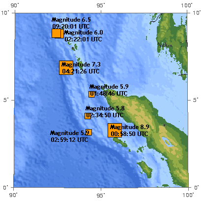
- Lines of longitude (meridians) are not parallel; they converge going north of the equator. Tverbeek 22:54, 28 Dec 2004 (UTC)
- I have the same problem: In firefox it looks good, but in konqueror it is "warped" (the upper side of the image is pushed one full image length to the left) - This is a screenshot: http://bill.infidyne.com/~magnus/warped_image.jpg -- 83.253.29.164 15:55, 30 Dec 2004 (UTC)
- There is a tsunami photoarchive with thousands of photos and Aid Organisation references here at www.photoduck.com/pollyfodder
Some of these images appear to be edited/fake. http://www.waveofdestruction.org/photos
- Could you please be more specific in indicating which photo had been altered? -- Andylkl 07:13, Dec 30, 2004 (UTC)
- I read on another website that at least of the photos is of a previous tsunami on the coast of China. BanyanTree 07:17, 30 Dec 2004 (UTC)
- Geoff here, (webmaster of WOD) it's time to clear these pictures up once and for all, the pictures in question are: http://www.waveofdestruction.org/photos/gagreflex.html
I recieved those pictures via email a a couple days after the site launched and I put them online, the next day I was informed by many of my readers that the images are from a tidal surge in China (or the surrounding areas).
Straight away I relabeled all the images to reflect this discovery, the only reason they are still in the gallery is to let ppls know of the error.
Hope that clears it up.
http://www.digitalglobe.com/tsunami_gallery.html - Include these?

Has anyone else noticed that there are some strange things about the flash animation of the tsunami's path, the one we got from NOAA. That would be one. If you look at it carefully, the tsunami originates from where the 2 6-magnitude earthquakes are, north of the epicenter by quite a bit, just off the islands. The damage done in Aceh by a tsunami originating there should have been significantly smaller than it was, and the damage done in Bangladesh should have been significantly larger. Also, the tsunami seems to stop just off the coast of Bangladesh and wait for the rest of it to hit Sri_Lanka, which is odd since there's no evidence that I can find of significant coral reefs there to slow down the wave. In all, this looks like a very badly done creation, or at least like there's a huge disconnect between the animation and the story.
- There's nothing unusual about this. The epicenter of the quake was just north of Simeulue, but this quake very soon caused a full 1200 km of faultline to slip, in an arc running northwards along the Nicobar and Andaman Islands. So the tsunamis were generated along this entire arc, not from a point source at the epicenter. Also, tsunamis move extremely rapidly in deep ocean water but slow down considerably in shallower water... and they also rise considerably in height when they reach shallow water.
I have created a blank map from de:Bild:Indischer Ozean Beben2004.png. It's a good map. Anyone cared to finish this job? I have to do my own job now. -- Toytoy 08:20, Dec 27, 2004 (UTC)
I have removed the image gallery from my website and uploaded the photos to the commons at commons:2004 Indian Ocean earthquake, all under GFDL. Please use any of those images if you prefer. Matthewmayer 13:10, 27 Dec 2004 (UTC)
There is a massive photoarchive of the tsunami Disaster here at www.photoduck.com/pollyfodder
Has anyone seen video of this Tsuanmi on the web? If so please leave the link. I have been unsucesful in finding any.
Thanks
- Reportedly, there is a video of the tsunami from a camera from a hotel in Malaysia. From what I have heard, this has aired on several Indian news channels. I do not know if it has aired on any US channels. Fadetoblack 23:30, 28 Dec 2004 (UTC)
- I think the Malaysian videa that Fadetoblack is referring to available here (along with several others): http://www.nbc10.com/news/4026938/detail.html Jpo 23:46, Dec 28, 2004 (UTC)
- I saw a movie on CNN's Anderson Cooper 360 of the tsunami from the POV of a tourist in (I believe) Thailand in a hotel, with the water rising and two tourists being swept away. Goodralph 05:02, 29 Dec 2004 (UTC)
- Numerous 2004 Tsunami Videos on P2P networks, like eMule, Gnutella. I've got 10+ at hand. But I don't have the bandwidth to serve it to Wikipedia's visitors, considering its enormous traffic. Leave me msg if you want them. I'll either show you how to obtain them, or send it to you.
- I also don't want to upload them onto Wikipedia's server too, it will overload everything if Wikipedia serves videos (2 - 30MB each) -- Godric 20:14, Dec 30, 2004 (UTC)
-
seems warped on the page (using
Konqueror) but not on this link or the image page. Anybody else noticed anything? -
Skysmith 10:19, 28 Dec 2004 (UTC)
- Lines of longitude (meridians) are not parallel; they converge going north of the equator. Tverbeek 22:54, 28 Dec 2004 (UTC)
- I have the same problem: In firefox it looks good, but in konqueror it is "warped" (the upper side of the image is pushed one full image length to the left) - This is a screenshot: http://bill.infidyne.com/~magnus/warped_image.jpg -- 83.253.29.164 15:55, 30 Dec 2004 (UTC)
- There is a tsunami photoarchive with thousands of photos and Aid Organisation references here at www.photoduck.com/pollyfodder
Some of these images appear to be edited/fake. http://www.waveofdestruction.org/photos
- Could you please be more specific in indicating which photo had been altered? -- Andylkl 07:13, Dec 30, 2004 (UTC)
- I read on another website that at least of the photos is of a previous tsunami on the coast of China. BanyanTree 07:17, 30 Dec 2004 (UTC)
- Geoff here, (webmaster of WOD) it's time to clear these pictures up once and for all, the pictures in question are: http://www.waveofdestruction.org/photos/gagreflex.html
I recieved those pictures via email a a couple days after the site launched and I put them online, the next day I was informed by many of my readers that the images are from a tidal surge in China (or the surrounding areas).
Straight away I relabeled all the images to reflect this discovery, the only reason they are still in the gallery is to let ppls know of the error.
Hope that clears it up.
http://www.digitalglobe.com/tsunami_gallery.html - Include these?
Has anyone else noticed that there are some strange things about the flash animation of the tsunami's path, the one we got from NOAA. That would be one. If you look at it carefully, the tsunami originates from where the 2 6-magnitude earthquakes are, north of the epicenter by quite a bit, just off the islands. The damage done in Aceh by a tsunami originating there should have been significantly smaller than it was, and the damage done in Bangladesh should have been significantly larger. Also, the tsunami seems to stop just off the coast of Bangladesh and wait for the rest of it to hit Sri_Lanka, which is odd since there's no evidence that I can find of significant coral reefs there to slow down the wave. In all, this looks like a very badly done creation, or at least like there's a huge disconnect between the animation and the story.
- There's nothing unusual about this. The epicenter of the quake was just north of Simeulue, but this quake very soon caused a full 1200 km of faultline to slip, in an arc running northwards along the Nicobar and Andaman Islands. So the tsunamis were generated along this entire arc, not from a point source at the epicenter. Also, tsunamis move extremely rapidly in deep ocean water but slow down considerably in shallower water... and they also rise considerably in height when they reach shallow water.