Photos • Location
Tahier | |
|---|---|
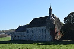
 Tahier, 17th-century fortified farm | |
| Coordinates: 50°25′37″N 05°13′17″E / 50.42694°N 5.22139°E | |
| Country | |
| Region | |
| Province | |
| Municipality | |
Tahier is a hamlet of the village of Évelette, Wallonia located in the municipality of Ohey, province of Namur, Belgium.
The village contains a chapel dedicated to Saint Servais from the 11th century, restored in the 18th century. There is also a fortified farm complex from the first half of the 17th century in the village. [1]
- ^ Menne, Gilbert, ed. (2014). Le grand guide de Wallonie et de Bruxelles. Brussels: Racine. p. 826. ISBN 978-94-014-1418-0.
-
 Media related to
Tahier at Wikimedia Commons
Tahier | |
|---|---|
 Tahier, 17th-century fortified farm | |
| Coordinates: 50°25′37″N 05°13′17″E / 50.42694°N 5.22139°E | |
| Country | |
| Region | |
| Province | |
| Municipality | |
Tahier is a hamlet of the village of Évelette, Wallonia located in the municipality of Ohey, province of Namur, Belgium.
The village contains a chapel dedicated to Saint Servais from the 11th century, restored in the 18th century. There is also a fortified farm complex from the first half of the 17th century in the village. [1]
- ^ Menne, Gilbert, ed. (2014). Le grand guide de Wallonie et de Bruxelles. Brussels: Racine. p. 826. ISBN 978-94-014-1418-0.
-
 Media related to
Tahier at Wikimedia Commons

