Photos • Location
| Tabasara River | |
|---|---|
 | |
| Native name | Rio Tabasara ( Spanish) |
| Location | |
| Country | Panama |
| Physical characteristics | |
| Mouth | |
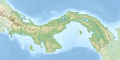
• coordinates | 8°01′43″N 81°42′02″W / 8.0286°N 81.7006°W |
The Tabasara River is a river of Panama. The Barro Blanco dam, a gravity dam, was built on the Tabasara river. It began generating in 2017.
- Rand McNally, The New International Atlas, 1993.
- CIA map, 1995
| Tabasara River | |
|---|---|
 | |
| Native name | Rio Tabasara ( Spanish) |
| Location | |
| Country | Panama |
| Physical characteristics | |
| Mouth | |
• coordinates | 8°01′43″N 81°42′02″W / 8.0286°N 81.7006°W |
The Tabasara River is a river of Panama. The Barro Blanco dam, a gravity dam, was built on the Tabasara river. It began generating in 2017.
- Rand McNally, The New International Atlas, 1993.
- CIA map, 1995
