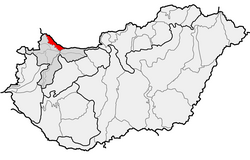

The Szigetköz (literally "island alley"; German: Kleine Schüttinsel, lit. 'Little Schütt Island'; Slovak: Malý Žitný ostrov, lit. 'Little Rye Island') is an island on the Danube in Western Hungary, part of the Little Hungarian Plain. It is the largest island in Hungary, with an area of 375 square kilometres (145 square miles). [1] The territory's elevation varies between 110 and 125 metres (361 and 410 feet) above sea level.[ citation needed]
See also
References
- ^ Fitch, Chris (2017). "Down the Danube: Pack riding". Geographical. 89 (11): 57–60.
- . Collier's New Encyclopedia. 1921.
- . New International Encyclopedia. 1905.
47°51′N 17°27′E / 47.85°N 17.45°E
