Sveti Rok | |
|---|---|
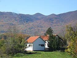
 A farm near Sveti Rok and Velebit Mountain. | |
| Coordinates: 44°21′41″N 15°39′13″E / 44.361368°N 15.653636°E | |
| Country | |
| County | |
| Municipality | Lovinac |
| Area | |
| • Total | 102.8 km2 (39.7 sq mi) |
| Population (2021)
[2] | |
| • Total | 250 |
| • Density | 2.4/km2 (6.3/sq mi) |
| Time zone | UTC+1 Central European Time |
Sveti Rok is a village in the Lovinac municipality, in Lika–Senj County, Croatia.
Today it is best known as the eponym of the Sveti Rok Tunnel, whose northern entrance is south of the village.
In the 2011 census, Sveti Rok had a population of 292, and the majority were Croats.
History
Until 1918, Sveti Rok (named Sanct Roch before 1850) was part of the Austrian monarchy ( Kingdom of Croatia-Slavonia after the compromise of 1867), in the Croatian Military Frontier, Likaner Regiment N°I. [3] The village named after Saint Roch.
Notable people
- Mile Budak, Ustaše ideologist
References
- ^ Register of spatial units of the State Geodetic Administration of the Republic of Croatia. Wikidata Q119585703.
- ^ "Population by Age and Sex, by Settlements, 2021 Census". Census of Population, Households and Dwellings in 2021. Zagreb: Croatian Bureau of Statistics. 2022.
- ^ Handbook of Austria and Lombardy-Venetia Cancellations on the Postage Stamp Issues 1850-1864, by Edwin MUELLER, 1961.
Sveti Rok | |
|---|---|
 A farm near Sveti Rok and Velebit Mountain. | |
| Coordinates: 44°21′41″N 15°39′13″E / 44.361368°N 15.653636°E | |
| Country | |
| County | |
| Municipality | Lovinac |
| Area | |
| • Total | 102.8 km2 (39.7 sq mi) |
| Population (2021)
[2] | |
| • Total | 250 |
| • Density | 2.4/km2 (6.3/sq mi) |
| Time zone | UTC+1 Central European Time |
Sveti Rok is a village in the Lovinac municipality, in Lika–Senj County, Croatia.
Today it is best known as the eponym of the Sveti Rok Tunnel, whose northern entrance is south of the village.
In the 2011 census, Sveti Rok had a population of 292, and the majority were Croats.
History
Until 1918, Sveti Rok (named Sanct Roch before 1850) was part of the Austrian monarchy ( Kingdom of Croatia-Slavonia after the compromise of 1867), in the Croatian Military Frontier, Likaner Regiment N°I. [3] The village named after Saint Roch.
Notable people
- Mile Budak, Ustaše ideologist
References
- ^ Register of spatial units of the State Geodetic Administration of the Republic of Croatia. Wikidata Q119585703.
- ^ "Population by Age and Sex, by Settlements, 2021 Census". Census of Population, Households and Dwellings in 2021. Zagreb: Croatian Bureau of Statistics. 2022.
- ^ Handbook of Austria and Lombardy-Venetia Cancellations on the Postage Stamp Issues 1850-1864, by Edwin MUELLER, 1961.
