Sučany | |
|---|---|
Village | |
 Protestant church | |
 Coat of arms | |
 Sučany Location of Sučany in Slovakia | |
| Coordinates: 49°06′00″N 18°59′30″E / 49.10000°N 18.99167°E | |
| Country | Slovakia |
| Region | Žilina |
| District | Martin |
| First mentioned | 1258 |
| Area | |
| • Total | 33.26 [2] km2 (12.84 [2] sq mi) |
| Elevation | 392 [3] m (1,286 [3] ft) |
| Population (
2021) | |
| • Total | 4,758 [1] |
| Postal code | 038 52
[3] |
| Area code | +421 43 [3] |
| Car plate | MT |
| Website | www.sucany.sk |
Sučany ( Hungarian: Szucsány, (til 1895) Szucsán) is a village and municipality in Martin District in the Žilina Region of northern Slovakia. It is located around 5 km northeast of Martin, in the Váh river valley.
History
In historical records the village was first mentioned in 1258. Before the establishment of independent Czechoslovakia in 1918, it was part of Turóc County within the Kingdom of Hungary. From 1939 to 1945, it was part of the Slovak Republic.
Geography
The municipality lies at an altitude of 393 metres and covers an area of 33.264 km². It has a population of about 4,644 people. 9 kilometres (5.6 mi) to the north is the 1,509.3-metre (4,952 ft) high peak of Stratenec, part of the Krivánska Malá Fatra mountain range.
Notable people
Natives
- Lőrinc Nyáry [ hu], Hungarian: bedeghi Nyáry Lőrinc ( c.1517–1558/59), castle captain, Governor of the Hont County, Crown guardian
- Daniel Sinapius-Horčička [ sk], Hungarian: (Sinapius, Synapius) Horcsicska Dániel (1640–1688), baroque writer, poet, dramatist, composer of hymns and evangelical Protestant preacher
- (Juraj) "Ďurko" Langsfeld [ sk] (1825–1849), a volunteer officer, participant in the Revolution of 1848–49, executed in Körmöcbánya
- Milan Hodža [ sk], Hungarian: Hodzsa Milán (1878–1944), Slovak politician, statesman and publicist, Prime Minister of Czechoslovakia (1935–1938)
- Jozef Turanec [ sk] (1892–1957), General of the Slovak Army during the Second World War
- Vojtech Wick [ sk] (1908–1985), lawyer and music composer
- (s) Rudolf Petrák (1917–1972), opera singer (tenor)
- Ján Siakeľ [ sk] (1920–1945), editor and Resistance member
- Rudo Moric [ sk] (1921–1985), novelist and journalist
- Peter Rusnák (architect) [ sk] (* 1948), architect and development planner
- (s) Martin Ďurík (* 1990), music producer
Active here
- Augustín Doležal [ sk] (1737, Szakolca ( Skalica)–1802), poet, Protestant priest and teacher
- Ondrej Hodža [ sk] (1819, Raksa (Kisraksa, Rakša)–1888), Protestant priest, national cultural worker, and church dignitary
- Jozef Juraj Styk [ sk] (1897, Alsókubin (Dolný Kubín)–1965), politician and economic worker
- Dušan Jamriška [ sk] (1903, Mossóc (Moschitz, Mošovce)–1979), officer and Resistance member
Twin towns — sister cities
-
 Fulnek, Czech Republic
Gallery
-
 Assumption of Virgin Mary Church
 -
 Protestant church
 -
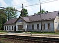 Train station
 -
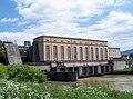 Hydroelectric power plant


References
- ^ "Počet obyvateľov podľa pohlavia - obce (ročne)". www.statistics.sk (in Slovak). Statistical Office of the Slovak Republic. 2022-03-31. Retrieved 2022-03-31.
- ^ a b "Hustota obyvateľstva - obce [om7014rr_ukaz: Rozloha (Štvorcový meter)]". www.statistics.sk (in Slovak). Statistical Office of the Slovak Republic. 2022-03-31. Retrieved 2022-03-31.
- ^ a b c d "Základná charakteristika". www.statistics.sk (in Slovak). Statistical Office of the Slovak Republic. 2015-04-17. Retrieved 2022-03-31.
- ^ a b "Hustota obyvateľstva - obce". www.statistics.sk (in Slovak). Statistical Office of the Slovak Republic. 2022-03-31. Retrieved 2022-03-31.
- ^ "Spoločenské organizácie". sucany.sk (in Slovak). Sučany. Retrieved 2019-09-09.
External links
- Official website (in Slovak)
| Authority control databases: National |
|---|
|
| This Žilina Region geography article is a stub. You can help Wikipedia by expanding it. |
Sučany | |
|---|---|
Village | |
|
Protestant church | |
|
Coat of arms | |
Sučany Location of Sučany in Slovakia | |
| Coordinates: 49°06′00″N 18°59′30″E / 49.10000°N 18.99167°E | |
| Country | Slovakia |
| Region | Žilina |
| District | Martin |
| First mentioned | 1258 |
| Area | |
| • Total | 33.26 [2] km2 (12.84 [2] sq mi) |
| Elevation | 392 [3] m (1,286 [3] ft) |
| Population (
2021) | |
| • Total | 4,758 [1] |
| Postal code | 038 52
[3] |
| Area code | +421 43 [3] |
| Car plate | MT |
| Website | www.sucany.sk |
Sučany ( Hungarian: Szucsány, (til 1895) Szucsán) is a village and municipality in Martin District in the Žilina Region of northern Slovakia. It is located around 5 km northeast of Martin, in the Váh river valley.
History
In historical records the village was first mentioned in 1258. Before the establishment of independent Czechoslovakia in 1918, it was part of Turóc County within the Kingdom of Hungary. From 1939 to 1945, it was part of the Slovak Republic.
Geography
The municipality lies at an altitude of 393 metres and covers an area of 33.264 km². It has a population of about 4,644 people. 9 kilometres (5.6 mi) to the north is the 1,509.3-metre (4,952 ft) high peak of Stratenec, part of the Krivánska Malá Fatra mountain range.
Notable people
Natives
- Lőrinc Nyáry [ hu], Hungarian: bedeghi Nyáry Lőrinc ( c.1517–1558/59), castle captain, Governor of the Hont County, Crown guardian
- Daniel Sinapius-Horčička [ sk], Hungarian: (Sinapius, Synapius) Horcsicska Dániel (1640–1688), baroque writer, poet, dramatist, composer of hymns and evangelical Protestant preacher
- (Juraj) "Ďurko" Langsfeld [ sk] (1825–1849), a volunteer officer, participant in the Revolution of 1848–49, executed in Körmöcbánya
- Milan Hodža [ sk], Hungarian: Hodzsa Milán (1878–1944), Slovak politician, statesman and publicist, Prime Minister of Czechoslovakia (1935–1938)
- Jozef Turanec [ sk] (1892–1957), General of the Slovak Army during the Second World War
- Vojtech Wick [ sk] (1908–1985), lawyer and music composer
- (s) Rudolf Petrák (1917–1972), opera singer (tenor)
- Ján Siakeľ [ sk] (1920–1945), editor and Resistance member
- Rudo Moric [ sk] (1921–1985), novelist and journalist
- Peter Rusnák (architect) [ sk] (* 1948), architect and development planner
- (s) Martin Ďurík (* 1990), music producer
Active here
- Augustín Doležal [ sk] (1737, Szakolca ( Skalica)–1802), poet, Protestant priest and teacher
- Ondrej Hodža [ sk] (1819, Raksa (Kisraksa, Rakša)–1888), Protestant priest, national cultural worker, and church dignitary
- Jozef Juraj Styk [ sk] (1897, Alsókubin (Dolný Kubín)–1965), politician and economic worker
- Dušan Jamriška [ sk] (1903, Mossóc (Moschitz, Mošovce)–1979), officer and Resistance member
Twin towns — sister cities
-
Fulnek, Czech Republic
Gallery
-
Assumption of Virgin Mary Church
-
Protestant church
-
Train station
-
Hydroelectric power plant
References
- ^ "Počet obyvateľov podľa pohlavia - obce (ročne)". www.statistics.sk (in Slovak). Statistical Office of the Slovak Republic. 2022-03-31. Retrieved 2022-03-31.
- ^ a b "Hustota obyvateľstva - obce [om7014rr_ukaz: Rozloha (Štvorcový meter)]". www.statistics.sk (in Slovak). Statistical Office of the Slovak Republic. 2022-03-31. Retrieved 2022-03-31.
- ^ a b c d "Základná charakteristika". www.statistics.sk (in Slovak). Statistical Office of the Slovak Republic. 2015-04-17. Retrieved 2022-03-31.
- ^ a b "Hustota obyvateľstva - obce". www.statistics.sk (in Slovak). Statistical Office of the Slovak Republic. 2022-03-31. Retrieved 2022-03-31.
- ^ "Spoločenské organizácie". sucany.sk (in Slovak). Sučany. Retrieved 2019-09-09.
External links
- Official website (in Slovak)
| Authority control databases: National |
|---|
|
| This Žilina Region geography article is a stub. You can help Wikipedia by expanding it. |