-
 Stitched panorama showing all four Strawberry Islands
 -
 Boys building kayaks at Adventure Island Camp. Adventure Island is also known as Big Strawberry Island.
 -
 Jack Island, diagram drawn after a visit by airplane in 1976
 -
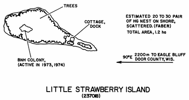 Little Strawberry Island, diagram drawn from observations made in 1975 or shortly before
Photos • Location

 Strawberry Islands from mainland | |
 Strawberry Islands  Strawberry Islands | |
| Geography | |
|---|---|
| Location | Door County, Wisconsin |
| Coordinates | 45°10′16″N 87°16′06″W / 45.17111°N 87.26833°W |
| Adjacent to | Lake Michigan |
| Highest elevation | 581 ft (177.1 m) |
| Administration | |
| State | Wisconsin |
| County | Door |
| Town | Gibraltar |
The Strawberry Islands are a small chain of four islands located on the Wisconsin side of Green Bay between Chambers Island and Peninsula State Park. [1] The islands are part of the Town of Gibraltar, Wisconsin.
The islands were likely occupied for thousands of years by indigenous peoples. Gradually the historic Ojibwe people moved into the area around the Great Lakes, where they competed with the existing Sioux (Lakota). They pushed the Sioux west into the Great Plains, with their last battle occurring in 1745.
The islands and the adjacent Strawberry Channel were part of a border dispute between Wisconsin and Michigan that was eventually resolved in the 1926 United States Supreme Court case Michigan v. Wisconsin. [2]
The northernmost island of the chain is Pirate Island, which at high water levels is little more than a reef awash. The next island to the south is Jack Island, and the next to the south is Little Strawberry Island. The largest island at the very southern tip of the chain is named Adventure Island. Today, all but Pirate Island are privately owned. [3]
Climate
| ||||||||||||||||||||||||||||||||||||||||||||||||||||||||||||||||||||||||||||||||||||||||||||||||||||||||||||||||||||||||||||
Gallery


References
- ^ "Strawberry Islands". Geographic Names Information System. United States Geological Survey, United States Department of the Interior. Retrieved 2011-05-14.
-
^ Martin, Lawrence (1965).
The physical geography of Wisconsin (3 ed.). University of Wisconsin Press. p.
423.
ISBN
0-299-03475-5.
strawberry islands wisconsin.
- ^ "Strawberry Islands", Door County, Wisconsin
- ^ "NASA EarthData Search". NASA. Retrieved 30 January 2016.
External links
- Adventure Island, Web-Map of Door County, Wisconsin
- Little Strawberry Island, Web-Map of Door County, Wisconsin
- Jack Island, Web-Map of Door County, Wisconsin
- Pirate Island, Web-Map of Door County, Wisconsin
Lake Michigan Islands | ||||
|---|---|---|---|---|
| Michigan |
|  | ||
| Wisconsin |
| |||
|
Strawberry Islands from mainland | |
Strawberry Islands Strawberry Islands | |
| Geography | |
|---|---|
| Location | Door County, Wisconsin |
| Coordinates | 45°10′16″N 87°16′06″W / 45.17111°N 87.26833°W |
| Adjacent to | Lake Michigan |
| Highest elevation | 581 ft (177.1 m) |
| Administration | |
| State | Wisconsin |
| County | Door |
| Town | Gibraltar |
The Strawberry Islands are a small chain of four islands located on the Wisconsin side of Green Bay between Chambers Island and Peninsula State Park. [1] The islands are part of the Town of Gibraltar, Wisconsin.
The islands were likely occupied for thousands of years by indigenous peoples. Gradually the historic Ojibwe people moved into the area around the Great Lakes, where they competed with the existing Sioux (Lakota). They pushed the Sioux west into the Great Plains, with their last battle occurring in 1745.
The islands and the adjacent Strawberry Channel were part of a border dispute between Wisconsin and Michigan that was eventually resolved in the 1926 United States Supreme Court case Michigan v. Wisconsin. [2]
The northernmost island of the chain is Pirate Island, which at high water levels is little more than a reef awash. The next island to the south is Jack Island, and the next to the south is Little Strawberry Island. The largest island at the very southern tip of the chain is named Adventure Island. Today, all but Pirate Island are privately owned. [3]
Climate
| ||||||||||||||||||||||||||||||||||||||||||||||||||||||||||||||||||||||||||||||||||||||||||||||||||||||||||||||||||||||||||||
Gallery
-
Stitched panorama showing all four Strawberry Islands
-
Boys building kayaks at Adventure Island Camp. Adventure Island is also known as Big Strawberry Island.
-
Jack Island, diagram drawn after a visit by airplane in 1976
-
Little Strawberry Island, diagram drawn from observations made in 1975 or shortly before
References
- ^ "Strawberry Islands". Geographic Names Information System. United States Geological Survey, United States Department of the Interior. Retrieved 2011-05-14.
-
^ Martin, Lawrence (1965).
The physical geography of Wisconsin (3 ed.). University of Wisconsin Press. p.
423.
ISBN
0-299-03475-5.
strawberry islands wisconsin.
- ^ "Strawberry Islands", Door County, Wisconsin
- ^ "NASA EarthData Search". NASA. Retrieved 30 January 2016.
External links
- Adventure Island, Web-Map of Door County, Wisconsin
- Little Strawberry Island, Web-Map of Door County, Wisconsin
- Jack Island, Web-Map of Door County, Wisconsin
- Pirate Island, Web-Map of Door County, Wisconsin
Lake Michigan Islands | ||||
|---|---|---|---|---|
| Michigan |
| | ||
| Wisconsin |
| |||