Photos • Location
(Redirected from
Storhorn)
| Storehorn | |
|---|---|
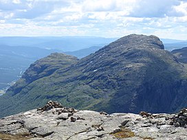
 Storehorn (right summit) in the summer as seen from
Totten. | |
| Highest point | |
| Elevation | 1,482 m (4,862 ft) |
| Coordinates | 60°49′1″N 8°35′36″E / 60.81694°N 8.59333°E |
| Geography | |
| Location | Hemsedal ( Buskerud) |
| Topo map | 1616 IV Hemsedal |
Storehorn, also written Storehødn, is a mountain located in the Hemsedal municipality. It is a part of Hemsedal Top 20.
(Redirected from
Storhorn)
| Storehorn | |
|---|---|
 Storehorn (right summit) in the summer as seen from
Totten. | |
| Highest point | |
| Elevation | 1,482 m (4,862 ft) |
| Coordinates | 60°49′1″N 8°35′36″E / 60.81694°N 8.59333°E |
| Geography | |
| Location | Hemsedal ( Buskerud) |
| Topo map | 1616 IV Hemsedal |
Storehorn, also written Storehødn, is a mountain located in the Hemsedal municipality. It is a part of Hemsedal Top 20.