Stompetoren | |
|---|---|
Village | |
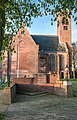
 Church with stubby tower | |
 Stompetoren Location in the Netherlands  Stompetoren Location in the province of North Holland in the Netherlands | |
| Coordinates: 52°37′N 4°49′E / 52.617°N 4.817°E | |
| Country | Netherlands |
| Province | North Holland |
| Municipality | Alkmaar |
| Area | |
| • Total | 11.15 km2 (4.31 sq mi) |
| Elevation | −3.2 m (−10.5 ft) |
| Population (2021)
[1] | |
| • Total | 2,025 |
| • Density | 180/km2 (470/sq mi) |
| Time zone | UTC+1 ( CET) |
| • Summer ( DST) | UTC+2 ( CEST) |
| Postal code | 1841
[1] |
| Dialing code | 072 |
Stompetoren is a village in the Dutch province of North Holland. It is a part of the municipality of Alkmaar, and lies about 6 km southeast of the city of Alkmaar.
History
The village was first mentioned in 1680 as Kerck. The current name means "stubby tower" after the shape of the Dutch Reformed church tower. [3] Stompetoren developed after the Schermer was poldered in 1635 on the intersection of the Noordervaart with the Oterlekerweg. [4]
The Dutch Reformed church is a single aisled church with a baluster on top of the tower, but without a spire. The church was built between 1662 and 1663. Wittenburg is an estate in Renaissance Revival style and surrounded by a moat. It was constructed in 1889 and replaces a farm. Between 1986 and 1987, it was converted to serve as town hall. [4]
Stompetoren was home to 123 people in 1840. [5]
Gallery
-
 Farm in Stompetoren
 -
 War monument in front the church
 -
 Polder mill


References
- ^ a b c "Kerncijfers wijken en buurten 2021". Central Bureau of Statistics. Retrieved 28 April 2022.
- ^ "Postcodetool for 1841EA". Actueel Hoogtebestand Nederland (in Dutch). Het Waterschapshuis. Retrieved 28 April 2022.
- ^ "Stompetoren - (geografische naam)". Etymologiebank (in Dutch). Retrieved 28 April 2022.
- ^ a b Ronald Stenvert & Saskia van Ginkel-Meester (2006). "Stompetoren" (in Dutch). Zwolle: Waanders. Retrieved 28 April 2022.
- ^ "Stompetoren". Plaatsengids (in Dutch). Retrieved 28 April 2022.
|
| This North Holland location article is a stub. You can help Wikipedia by expanding it. |
Stompetoren | |
|---|---|
Village | |
|
Church with stubby tower | |
Stompetoren Location in the Netherlands Stompetoren Location in the province of North Holland in the Netherlands | |
| Coordinates: 52°37′N 4°49′E / 52.617°N 4.817°E | |
| Country | Netherlands |
| Province | North Holland |
| Municipality | Alkmaar |
| Area | |
| • Total | 11.15 km2 (4.31 sq mi) |
| Elevation | −3.2 m (−10.5 ft) |
| Population (2021)
[1] | |
| • Total | 2,025 |
| • Density | 180/km2 (470/sq mi) |
| Time zone | UTC+1 ( CET) |
| • Summer ( DST) | UTC+2 ( CEST) |
| Postal code | 1841
[1] |
| Dialing code | 072 |
Stompetoren is a village in the Dutch province of North Holland. It is a part of the municipality of Alkmaar, and lies about 6 km southeast of the city of Alkmaar.
History
The village was first mentioned in 1680 as Kerck. The current name means "stubby tower" after the shape of the Dutch Reformed church tower. [3] Stompetoren developed after the Schermer was poldered in 1635 on the intersection of the Noordervaart with the Oterlekerweg. [4]
The Dutch Reformed church is a single aisled church with a baluster on top of the tower, but without a spire. The church was built between 1662 and 1663. Wittenburg is an estate in Renaissance Revival style and surrounded by a moat. It was constructed in 1889 and replaces a farm. Between 1986 and 1987, it was converted to serve as town hall. [4]
Stompetoren was home to 123 people in 1840. [5]
Gallery
-
Farm in Stompetoren
-
War monument in front the church
-
Polder mill
References
- ^ a b c "Kerncijfers wijken en buurten 2021". Central Bureau of Statistics. Retrieved 28 April 2022.
- ^ "Postcodetool for 1841EA". Actueel Hoogtebestand Nederland (in Dutch). Het Waterschapshuis. Retrieved 28 April 2022.
- ^ "Stompetoren - (geografische naam)". Etymologiebank (in Dutch). Retrieved 28 April 2022.
- ^ a b Ronald Stenvert & Saskia van Ginkel-Meester (2006). "Stompetoren" (in Dutch). Zwolle: Waanders. Retrieved 28 April 2022.
- ^ "Stompetoren". Plaatsengids (in Dutch). Retrieved 28 April 2022.
|
| This North Holland location article is a stub. You can help Wikipedia by expanding it. |