| Stożek Wielki | |
|---|---|
-09_2005.jpg) Stożek Wielki | |
| Highest point | |
| Elevation | 978 m (3,209 ft) [1] |
| Listing | Mountains of Poland |
| Coordinates | 49°36′20″N 18°49′23″E / 49.605556°N 18.823056°E |
| Geography | |
 Stożek Wielki Location of Stożek Wielki in Poland, on the Czech border  Stożek Wielki Stożek Wielki (Czech Republic) | |
| Location | Poland / Czech Republic |
| Parent range | Silesian Beskids |
| Climbing | |
| Easiest route | Hike |
Stożek Wielki ( Czech: Velký Stožek; literally "big cone") is a mountain on the border of Poland and the Czech Republic, in the Silesian Beskids mountain range. It reaches a height of 978 metres (3,209 ft).
The peak of the mountain has a characteristic conical shape and on its slopes grow beech and coniferous trees. It used to host a border crossing, which was eliminated in 2007 due to both countries entering the Schengen Area.
The mountain hut, located around 140 metres (460 ft) from the peak, [1] was built from the initiative of Polskie Towarzystwo Turystyczne "Beskid" (Polish Touristic Society "Beskid"). It was opened on 9 July 1922, with over four thousand visitors, national and regional government representatives, and hiking clubs in attendance. [2] [3]
Stożek Wielki can be accessed by hiking trails from the nearby municipalities from both sides of the border. There is also a ski resort on the mountain, which skiers can reach using the chairlift. [4]
Through a number of hiking routes it is possible to reach other summits such as Kubalonka, Czantoria Wielka, Soszów Wielki and towns, down into Wisła, Wisła-Głębce, Istebna, Jaworzynka and Jablunkov.
The Main Beskid Trail ( Polish: Główny Szlak Beskidzki), the major long distance hiking trail in the region, also crosses the peak. [5]
-
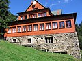 Mountain hut on Stożek

See also
References
- ^ a b "Stożek Wielki (Beskid Śląski)". Onet Podróże (in Polish). 2018-09-04. Archived from the original on 2022-11-28. Retrieved 2023-05-05.
- ^ Cicha, Irena (2007). Beskidzkie gronie nad Olzą i Wisłą (in Polish). Český Těšín: Regio. p. 111. ISBN 978-80-254-0261-0.
- ^ "Nasza historia – PTTK Oddział „Beskid Śląski" w Cieszynie" (in Polish). Archived from the original on 2021-06-30. Retrieved 2023-05-05.
- ^ "Trasy i wyciągi". stozekwisla.pl. Archived from the original on 2023-01-28. Retrieved 2023-05-05.
- ^ "Główny Szlak Beskidzki – Regionalny Serwis Turystyczny BeskidSlaski.pl" (in Polish). Archived from the original on 2023-02-05. Retrieved 2023-05-05.
| Stożek Wielki | |
|---|---|
|
Stożek Wielki | |
| Highest point | |
| Elevation | 978 m (3,209 ft) [1] |
| Listing | Mountains of Poland |
| Coordinates | 49°36′20″N 18°49′23″E / 49.605556°N 18.823056°E |
| Geography | |
Stożek Wielki Location of Stożek Wielki in Poland, on the Czech border Stożek Wielki Stożek Wielki (Czech Republic) | |
| Location | Poland / Czech Republic |
| Parent range | Silesian Beskids |
| Climbing | |
| Easiest route | Hike |
Stożek Wielki ( Czech: Velký Stožek; literally "big cone") is a mountain on the border of Poland and the Czech Republic, in the Silesian Beskids mountain range. It reaches a height of 978 metres (3,209 ft).
The peak of the mountain has a characteristic conical shape and on its slopes grow beech and coniferous trees. It used to host a border crossing, which was eliminated in 2007 due to both countries entering the Schengen Area.
The mountain hut, located around 140 metres (460 ft) from the peak, [1] was built from the initiative of Polskie Towarzystwo Turystyczne "Beskid" (Polish Touristic Society "Beskid"). It was opened on 9 July 1922, with over four thousand visitors, national and regional government representatives, and hiking clubs in attendance. [2] [3]
Stożek Wielki can be accessed by hiking trails from the nearby municipalities from both sides of the border. There is also a ski resort on the mountain, which skiers can reach using the chairlift. [4]
Through a number of hiking routes it is possible to reach other summits such as Kubalonka, Czantoria Wielka, Soszów Wielki and towns, down into Wisła, Wisła-Głębce, Istebna, Jaworzynka and Jablunkov.
The Main Beskid Trail ( Polish: Główny Szlak Beskidzki), the major long distance hiking trail in the region, also crosses the peak. [5]
-
Mountain hut on Stożek
See also
References
- ^ a b "Stożek Wielki (Beskid Śląski)". Onet Podróże (in Polish). 2018-09-04. Archived from the original on 2022-11-28. Retrieved 2023-05-05.
- ^ Cicha, Irena (2007). Beskidzkie gronie nad Olzą i Wisłą (in Polish). Český Těšín: Regio. p. 111. ISBN 978-80-254-0261-0.
- ^ "Nasza historia – PTTK Oddział „Beskid Śląski" w Cieszynie" (in Polish). Archived from the original on 2021-06-30. Retrieved 2023-05-05.
- ^ "Trasy i wyciągi". stozekwisla.pl. Archived from the original on 2023-01-28. Retrieved 2023-05-05.
- ^ "Główny Szlak Beskidzki – Regionalny Serwis Turystyczny BeskidSlaski.pl" (in Polish). Archived from the original on 2023-02-05. Retrieved 2023-05-05.