Stammheim | |
|---|---|
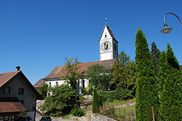
 Village church in Unterstammheim | |
| Coordinates: 47°38′N 8°47′E / 47.633°N 8.783°E | |
| Country | Switzerland |
| Canton | Zurich |
| District | Andelfingen |
| Area | |
| • Total | 2,393 km2 (924 sq mi) |
| Population (2017) | |
| • Total | 2,746 |
| • Density | 1.1/km2 (3.0/sq mi) |
| Time zone | UTC+01:00 ( Central European Time) |
| • Summer ( DST) | UTC+02:00 ( Central European Summer Time) |
| Postal code(s) | 8476, 77, 68 |
| SFOS number | 0292 |
| ISO 3166 code | CH-ZH |
| Surrounded by | Basadingen-Schlattingen (TG), Diessenhofen (TG), Wagenhausen (TG) |
| Website |
www SFSO statistics |
Stammheim is a municipality in the district of Andelfingen in the canton of Zürich in Switzerland. On 1 January 2019 the former municipalities of Oberstammheim, Unterstammheim and Waltalingen merged into the new municipality of Stammheim. [1]
History
Oberstammheim
In 2009, archaeologists announced the discovery of an Iron Age (late Hallstatt or early La Tène) tumulus burial, apparently of a Celtic nobleman. While there are comparable finds in Germany, the site is unique in Switzerland. [2]
Oberstammheim is first mentioned in 761 as Stamhaim. In 1212 it was mentioned as in Stamehein superiori. [3]
Geography
After the merger, Stammheim has an area, as of 2009 [update], of 23.95 km2 (9.25 sq mi). [4]
Demographics
The new municipality has a population (as of December 2020 [update]) of 2,859. [5]

Historic Population
The historical population is given in the following chart: [6]

References
- ^ "Amtliches Gemeindeverzeichnis der Schweiz". www.bfs.admin.ch (in German). Bundesamt für Statistik. Retrieved 3 January 2019.
- ^ Fürstengrab in Oberstammheim gefunden NZZ 21 August 2009.
- ^ Oberstammheim in German, French and Italian in the online Historical Dictionary of Switzerland.
- ^ Arealstatistik Standard - Gemeindedaten nach 4 Hauptbereichen
- ^ "Ständige und nichtständige Wohnbevölkerung nach institutionellen Gliederungen, Geburtsort und Staatsangehörigkeit". bfs.admin.ch (in German). Swiss Federal Statistical Office - STAT-TAB. 31 December 2020. Retrieved 21 September 2021.
- ^ Swiss Federal Statistical Office STAT-TAB Bevölkerungsentwicklung nach institutionellen Gliederungen, 1850-2000 (in German) accessed 27 April 2016
External links
Stammheim | |
|---|---|
 Village church in Unterstammheim | |
| Coordinates: 47°38′N 8°47′E / 47.633°N 8.783°E | |
| Country | Switzerland |
| Canton | Zurich |
| District | Andelfingen |
| Area | |
| • Total | 2,393 km2 (924 sq mi) |
| Population (2017) | |
| • Total | 2,746 |
| • Density | 1.1/km2 (3.0/sq mi) |
| Time zone | UTC+01:00 ( Central European Time) |
| • Summer ( DST) | UTC+02:00 ( Central European Summer Time) |
| Postal code(s) | 8476, 77, 68 |
| SFOS number | 0292 |
| ISO 3166 code | CH-ZH |
| Surrounded by | Basadingen-Schlattingen (TG), Diessenhofen (TG), Wagenhausen (TG) |
| Website |
www SFSO statistics |
Stammheim is a municipality in the district of Andelfingen in the canton of Zürich in Switzerland. On 1 January 2019 the former municipalities of Oberstammheim, Unterstammheim and Waltalingen merged into the new municipality of Stammheim. [1]
History
Oberstammheim
In 2009, archaeologists announced the discovery of an Iron Age (late Hallstatt or early La Tène) tumulus burial, apparently of a Celtic nobleman. While there are comparable finds in Germany, the site is unique in Switzerland. [2]
Oberstammheim is first mentioned in 761 as Stamhaim. In 1212 it was mentioned as in Stamehein superiori. [3]
Geography
After the merger, Stammheim has an area, as of 2009 [update], of 23.95 km2 (9.25 sq mi). [4]
Demographics
The new municipality has a population (as of December 2020 [update]) of 2,859. [5]

Historic Population
The historical population is given in the following chart: [6]

References
- ^ "Amtliches Gemeindeverzeichnis der Schweiz". www.bfs.admin.ch (in German). Bundesamt für Statistik. Retrieved 3 January 2019.
- ^ Fürstengrab in Oberstammheim gefunden NZZ 21 August 2009.
- ^ Oberstammheim in German, French and Italian in the online Historical Dictionary of Switzerland.
- ^ Arealstatistik Standard - Gemeindedaten nach 4 Hauptbereichen
- ^ "Ständige und nichtständige Wohnbevölkerung nach institutionellen Gliederungen, Geburtsort und Staatsangehörigkeit". bfs.admin.ch (in German). Swiss Federal Statistical Office - STAT-TAB. 31 December 2020. Retrieved 21 September 2021.
- ^ Swiss Federal Statistical Office STAT-TAB Bevölkerungsentwicklung nach institutionellen Gliederungen, 1850-2000 (in German) accessed 27 April 2016


