Photos • Location

Heath landscape near Sparkær, Jutland. Painting by
Gotfred Rode, 1891.

Sparkær | |
|---|---|
Railway town | |
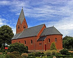
 Sparkær Church | |
| Coordinates: 56°28′43″N 9°13′45″E / 56.47861°N 9.22917°E | |
| Country | Denmark |
| Region | Central Denmark Region |
| Municipality | Viborg Municipality |
| Population (2024)
[1] | 616 |

Sparkær is a small railway town in Viborg Municipality in central Jutland, Denmark. It is located 15 kilometres (9.3 mi) west of Viborg. As of 1 January 2024, Sparkær has a population of 616. [1] Sparkær is located at the Langå-Struer railway line and is served by Sparkær railway station. [2]
- ^ a b BY3: Population 1. January, by urban areas The Mobile Statbank from Statistics Denmark
- ^ "Sparkær Station" (in Danish). GoCollective. Retrieved 20 April 2024.
Wikimedia Commons has media related to
Sparkær.
- Sparkær local website (in Danish)
56°28′33″N 9°13′41″E / 56.4758°N 9.2281°E
Sparkær | |
|---|---|
Railway town | |
 Sparkær Church | |
| Coordinates: 56°28′43″N 9°13′45″E / 56.47861°N 9.22917°E | |
| Country | Denmark |
| Region | Central Denmark Region |
| Municipality | Viborg Municipality |
| Population (2024)
[1] | 616 |

Sparkær is a small railway town in Viborg Municipality in central Jutland, Denmark. It is located 15 kilometres (9.3 mi) west of Viborg. As of 1 January 2024, Sparkær has a population of 616. [1] Sparkær is located at the Langå-Struer railway line and is served by Sparkær railway station. [2]
- ^ a b BY3: Population 1. January, by urban areas The Mobile Statbank from Statistics Denmark
- ^ "Sparkær Station" (in Danish). GoCollective. Retrieved 20 April 2024.
Wikimedia Commons has media related to
Sparkær.
- Sparkær local website (in Danish)
56°28′33″N 9°13′41″E / 56.4758°N 9.2281°E


