South Aylesbury Halt | |
|---|---|
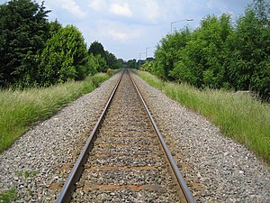
 Station site in 2006. | |
| General information | |
| Location |
Aylesbury,
District of Aylesbury Vale England |
| Grid reference | SP8213312477 |
| Platforms | 1 |
| Other information | |
| Status | Disused |
| History | |
| Original company | Great Western and Great Central Joint Railway |
| Post-grouping |
Great Western and Great Central Joint Railway Western Region of British Railways |
| Key dates | |
| 1933 | Opened |
| 1967 | Closed |
South Aylesbury Halt was a railway station which was opened in 1933 and was closed in 1967. It was located on the Aylesbury–Princes Risborough line. [1]
History
The station was opened by the Great Western Railway on 13 February 1933 to serve factories in the locality, as well as the Southcourt housing estate. [2] It was situated on a foot crossing between Mandeville Road and Old Stoke Road. In 1966, British Rail proposed the closure of the station which was queried by the East Midlands Transport Users Consultative Committee (TUCC) as usage figures showed that receipts were £130 per year while direct costs were only £26. [3] British Rail subsequently justified the closure on the basis of anticipated renewal costs of £2,500 and the TUCC approved the closure, as there would be no hardship caused. [4] The station closed on 5 June 1967. [5]
| Preceding station | Historical railways | Following station | ||
|---|---|---|---|---|
|
Aylesbury Line and station open |
Western Region of British Railways Aylesbury–Princes Risborough line |
Little Kimble Line and station open | ||
Present day
The station was demolished after closure and no trace remains. Pedestrian access across the railway was maintained at the station site until a fatality in November 2016 when a cyclist was killed. [6] The crossing has since been closed. [7]
References
- ^ "Pastscape - Detailed Result: SOUTH AYLESBURY HALT". Pastscape.org.uk. Retrieved 19 July 2018.
- ^ Maggs, Colin (2010). The Branch Lines of Buckinghamshire. Stroud, Gloucestershire: Amberley Publishing. ISBN 978-1848683426.
- ^ Gourvish, Terry (2011). British Railways 1948-73: A Business History. Cambridge: Cambridge University Press. p. 455. ISBN 978-0521188838.
- ^ Gourvish 2011, p. 455
- ^ Quick, Michael (2009) [2001]. Railway passenger stations in Great Britain: a chronology (4th ed.). Oxford: Railway & Canal Historical Society. p. 370. ISBN 978-0-901461-57-5. OCLC 612226077.
- ^ Marshall-Bell, Chris (9 November 2016). "Cyclist dies in Stoke Mandeville after being hit by train". Cycling Weekly. Archived from the original on 31 October 2020. Retrieved 26 May 2020.
- ^ "Network Rail closes two level crossings after tragic death and two near-misses". Bucks Herald. 16 January 2017. Retrieved 26 May 2020.
51°48′30.8″N 0°48′36.4″W / 51.808556°N 0.810111°W
South Aylesbury Halt | |
|---|---|
 Station site in 2006. | |
| General information | |
| Location |
Aylesbury,
District of Aylesbury Vale England |
| Grid reference | SP8213312477 |
| Platforms | 1 |
| Other information | |
| Status | Disused |
| History | |
| Original company | Great Western and Great Central Joint Railway |
| Post-grouping |
Great Western and Great Central Joint Railway Western Region of British Railways |
| Key dates | |
| 1933 | Opened |
| 1967 | Closed |
South Aylesbury Halt was a railway station which was opened in 1933 and was closed in 1967. It was located on the Aylesbury–Princes Risborough line. [1]
History
The station was opened by the Great Western Railway on 13 February 1933 to serve factories in the locality, as well as the Southcourt housing estate. [2] It was situated on a foot crossing between Mandeville Road and Old Stoke Road. In 1966, British Rail proposed the closure of the station which was queried by the East Midlands Transport Users Consultative Committee (TUCC) as usage figures showed that receipts were £130 per year while direct costs were only £26. [3] British Rail subsequently justified the closure on the basis of anticipated renewal costs of £2,500 and the TUCC approved the closure, as there would be no hardship caused. [4] The station closed on 5 June 1967. [5]
| Preceding station | Historical railways | Following station | ||
|---|---|---|---|---|
|
Aylesbury Line and station open |
Western Region of British Railways Aylesbury–Princes Risborough line |
Little Kimble Line and station open | ||
Present day
The station was demolished after closure and no trace remains. Pedestrian access across the railway was maintained at the station site until a fatality in November 2016 when a cyclist was killed. [6] The crossing has since been closed. [7]
References
- ^ "Pastscape - Detailed Result: SOUTH AYLESBURY HALT". Pastscape.org.uk. Retrieved 19 July 2018.
- ^ Maggs, Colin (2010). The Branch Lines of Buckinghamshire. Stroud, Gloucestershire: Amberley Publishing. ISBN 978-1848683426.
- ^ Gourvish, Terry (2011). British Railways 1948-73: A Business History. Cambridge: Cambridge University Press. p. 455. ISBN 978-0521188838.
- ^ Gourvish 2011, p. 455
- ^ Quick, Michael (2009) [2001]. Railway passenger stations in Great Britain: a chronology (4th ed.). Oxford: Railway & Canal Historical Society. p. 370. ISBN 978-0-901461-57-5. OCLC 612226077.
- ^ Marshall-Bell, Chris (9 November 2016). "Cyclist dies in Stoke Mandeville after being hit by train". Cycling Weekly. Archived from the original on 31 October 2020. Retrieved 26 May 2020.
- ^ "Network Rail closes two level crossings after tragic death and two near-misses". Bucks Herald. 16 January 2017. Retrieved 26 May 2020.
51°48′30.8″N 0°48′36.4″W / 51.808556°N 0.810111°W