You can help expand this article with text translated from
the corresponding article in Spanish. (July 2012) Click [show] for important translation instructions.
View a machine-translated version of the Spanish article.
Machine translation, like
DeepL or
Google Translate, is a useful starting point for translations, but translators must revise errors as necessary and confirm that the translation is accurate, rather than simply copy-pasting machine-translated text into the English Wikipedia.
Consider adding a topic to this template: there are already 5,023 articles in the
main category, and specifying|topic= will aid in categorization.
Do not translate text that appears unreliable or low-quality. If possible, verify the text with references provided in the foreign-language article.
You must provide
copyright attribution in the
edit summary accompanying your translation by providing an
interlanguage link to the source of your translation. A model attribution edit summary is Content in this edit is translated from the existing Spanish Wikipedia article at [[:es:Sotuta (cacicazgo)]]; see its history for attribution.
You may also add the template {{Translated|es|Sotuta (cacicazgo)}} to the
talk page.
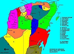
Sotuta is a small town and municipality of the Mexican state of
Yucatán, and also was the name of a Mayan chiefdom of the northern central
Yucatán Peninsula, before the arrival of the Spanish conquistadors in the sixteenth century.[1]
You can help expand this article with text translated from
the corresponding article in Spanish. (July 2012) Click [show] for important translation instructions.
View a machine-translated version of the Spanish article.
Machine translation, like
DeepL or
Google Translate, is a useful starting point for translations, but translators must revise errors as necessary and confirm that the translation is accurate, rather than simply copy-pasting machine-translated text into the English Wikipedia.
Consider adding a topic to this template: there are already 5,023 articles in the
main category, and specifying|topic= will aid in categorization.
Do not translate text that appears unreliable or low-quality. If possible, verify the text with references provided in the foreign-language article.
You must provide
copyright attribution in the
edit summary accompanying your translation by providing an
interlanguage link to the source of your translation. A model attribution edit summary is Content in this edit is translated from the existing Spanish Wikipedia article at [[:es:Sotuta (cacicazgo)]]; see its history for attribution.
You may also add the template {{Translated|es|Sotuta (cacicazgo)}} to the
talk page.
Sotuta is a small town and municipality of the Mexican state of
Yucatán, and also was the name of a Mayan chiefdom of the northern central
Yucatán Peninsula, before the arrival of the Spanish conquistadors in the sixteenth century.[1]