Photos • Location
| Soopoolitse | |||||||
|---|---|---|---|---|---|---|---|
| county of Ancient Estonia | |||||||
| 1224 | |||||||
 Ancient Estonian counties | |||||||
| Area | |||||||
| • Coordinates | 58°36′36″N 27°06′48″E / 58.61°N 27.1133°E | ||||||
| |||||||
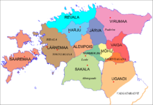
Soopoolitse was a small landlocked ancient Estonian county in the eastern part of the territory of Estonia.
See also
References
External links
| Soopoolitse | |||||||
|---|---|---|---|---|---|---|---|
| county of Ancient Estonia | |||||||
| 1224 | |||||||
 Ancient Estonian counties | |||||||
| Area | |||||||
| • Coordinates | 58°36′36″N 27°06′48″E / 58.61°N 27.1133°E | ||||||
| |||||||
Soopoolitse was a small landlocked ancient Estonian county in the eastern part of the territory of Estonia.