Photos • Location
| Sokobaru dam | |
|---|---|
 | |
| Location | Ishigaki, Okinawa, Japan |
| Coordinates | 24°25′21″N 124°13′18″E / 24.4225°N 124.2218°E |
| Status | Operational |
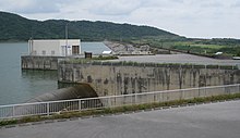
Sokubara dam (Japanese:底原ダム) is a man-made dam located in Ishigaki Island, Okinawa prefecture of southern Japan. [1] The dam is used to collect water for drinking purpose. [2] The dam lies in the catchment of Miyara River. [3] The dam came in operation in 1992 and has a capacity of 130Mm3. [4]
References
- ^ "底原ダム/沖縄県". Retrieved 2021-09-04.
- ^ "Southern Odyssey - Ishigaki Island". Retrieved 2021-09-04.
-
^ Banzai, Kenji; Nakamura, Ken. "Red Soil Runoff from the Miyara River, and an Environmental Problem on Ishigaki Island".
{{
cite journal}}
: Cite journal requires|journal=( help) - ^ "底原ダム[沖縄県] - ダム便覧". Retrieved 2021-09-04.
| Sokobaru dam | |
|---|---|
 | |
| Location | Ishigaki, Okinawa, Japan |
| Coordinates | 24°25′21″N 124°13′18″E / 24.4225°N 124.2218°E |
| Status | Operational |
Sokubara dam (Japanese:底原ダム) is a man-made dam located in Ishigaki Island, Okinawa prefecture of southern Japan. [1] The dam is used to collect water for drinking purpose. [2] The dam lies in the catchment of Miyara River. [3] The dam came in operation in 1992 and has a capacity of 130Mm3. [4]
References
- ^ "底原ダム/沖縄県". Retrieved 2021-09-04.
- ^ "Southern Odyssey - Ishigaki Island". Retrieved 2021-09-04.
-
^ Banzai, Kenji; Nakamura, Ken. "Red Soil Runoff from the Miyara River, and an Environmental Problem on Ishigaki Island".
{{
cite journal}}
: Cite journal requires|journal=( help) - ^ "底原ダム[沖縄県] - ダム便覧". Retrieved 2021-09-04.