Skreia | |
|---|---|
Village | |
.JPG) View of the village | |
 Skreia Location of the village  Skreia Skreia (Norway) | |
| Coordinates: 60°39′09″N 10°56′08″E / 60.65257°N 10.93564°E | |
| Country | Norway |
| Region | Eastern Norway |
| County | Innlandet |
| District | Toten |
| Municipality | Østre Toten Municipality |
| Area | |
| • Total | 1.02 km2 (0.39 sq mi) |
| Elevation | 153 m (502 ft) |
| Population (2021)
[1] | |
| • Total | 922 |
| • Density | 905/km2 (2,340/sq mi) |
| Time zone | UTC+01:00 ( CET) |
| • Summer ( DST) | UTC+02:00 ( CEST) |
| Post Code | 2848 Skreia |
Skreia is a village in Østre Toten Municipality in Innlandet county, Norway. The village is located on the western shore of the large lake Mjøsa, about 7 kilometres (4.3 mi) southeast of the village of Lena and about 8 kilometres (5.0 mi) to the south of the village of Kapp. In the summers, there is a ferry from Skreia across the lake to the town of Hamar. [3]
The 1.02-square-kilometre (250-acre) village has a population (2021) of 922 and a population density of 905 inhabitants per square kilometre (2,340/sq mi). [1]
Skreia was the terminus of Skreiabanen railway line. The now-abandoned railway line once ran between Reinsvoll and Skreia. The single track rail was a branch line from the main Gjøvik Line and it closed in 1987. [4]
Skreia is located along County Road 33 which runs between Bjørgo in Nord-Aurdal and Minnesund in Eidsvoll. The Ostre Toten Cultural Center (Østre Toten kulturhus) is located in Skreia. [5] The principal local industry is food production and the processing of potatoes and vegetables. [3]
Notable residents
- Alv Gjestvang, speed skater
- Inger Lise Rypdal, singer
- Maj Britt Andersen, singer
Media gallery
-
 Skreia Bridge
 -
 Skreia Main Street
 -
 Center of Skreia
 -
 Skreia Railway Station
 -
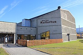 Østre Toten Cultural Center


References
- ^ a b c Statistisk sentralbyrå (1 January 2021). "Urban settlements. Population and area, by municipality".
- ^ "Skreia, Østre Toten". yr.no. Retrieved 20 October 2022.
- ^ a b Mæhlum, Lars, ed. (29 March 2022). "Skreia (tettsted)". Store norske leksikon (in Norwegian). Kunnskapsforlaget. Retrieved 20 October 2022.
- ^ Mæhlum, Lars, ed. (14 June 2018). "Skreiabanen". Store norske leksikon (in Norwegian). Kunnskapsforlaget. Retrieved 20 October 2022.
- ^ "Østre Toten kulturhus". Østre Toten kommune. Retrieved 1 October 2016.
|
| This Innlandet location article is a stub. You can help Wikipedia by expanding it. |
Skreia | |
|---|---|
Village | |
|
View of the village | |
Skreia Location of the village Skreia Skreia (Norway) | |
| Coordinates: 60°39′09″N 10°56′08″E / 60.65257°N 10.93564°E | |
| Country | Norway |
| Region | Eastern Norway |
| County | Innlandet |
| District | Toten |
| Municipality | Østre Toten Municipality |
| Area | |
| • Total | 1.02 km2 (0.39 sq mi) |
| Elevation | 153 m (502 ft) |
| Population (2021)
[1] | |
| • Total | 922 |
| • Density | 905/km2 (2,340/sq mi) |
| Time zone | UTC+01:00 ( CET) |
| • Summer ( DST) | UTC+02:00 ( CEST) |
| Post Code | 2848 Skreia |
Skreia is a village in Østre Toten Municipality in Innlandet county, Norway. The village is located on the western shore of the large lake Mjøsa, about 7 kilometres (4.3 mi) southeast of the village of Lena and about 8 kilometres (5.0 mi) to the south of the village of Kapp. In the summers, there is a ferry from Skreia across the lake to the town of Hamar. [3]
The 1.02-square-kilometre (250-acre) village has a population (2021) of 922 and a population density of 905 inhabitants per square kilometre (2,340/sq mi). [1]
Skreia was the terminus of Skreiabanen railway line. The now-abandoned railway line once ran between Reinsvoll and Skreia. The single track rail was a branch line from the main Gjøvik Line and it closed in 1987. [4]
Skreia is located along County Road 33 which runs between Bjørgo in Nord-Aurdal and Minnesund in Eidsvoll. The Ostre Toten Cultural Center (Østre Toten kulturhus) is located in Skreia. [5] The principal local industry is food production and the processing of potatoes and vegetables. [3]
Notable residents
- Alv Gjestvang, speed skater
- Inger Lise Rypdal, singer
- Maj Britt Andersen, singer
Media gallery
-
Skreia Bridge
-
Skreia Main Street
-
Center of Skreia
-
Skreia Railway Station
-
Østre Toten Cultural Center
References
- ^ a b c Statistisk sentralbyrå (1 January 2021). "Urban settlements. Population and area, by municipality".
- ^ "Skreia, Østre Toten". yr.no. Retrieved 20 October 2022.
- ^ a b Mæhlum, Lars, ed. (29 March 2022). "Skreia (tettsted)". Store norske leksikon (in Norwegian). Kunnskapsforlaget. Retrieved 20 October 2022.
- ^ Mæhlum, Lars, ed. (14 June 2018). "Skreiabanen". Store norske leksikon (in Norwegian). Kunnskapsforlaget. Retrieved 20 October 2022.
- ^ "Østre Toten kulturhus". Østre Toten kommune. Retrieved 1 October 2016.
|
| This Innlandet location article is a stub. You can help Wikipedia by expanding it. |